
 Country
North America
Guatemala
Guatemala is a country in Central America with tall volcanoes and old Maya cities. Many Maya people live there today. Its national bird is the shiny green quetzal.
Guatemala lies between Mexico and the rest of Central America. A row of 27 volcanoes crosses its south, and the great Maya city of Tikal rises from the rainforest of the north. About two-fifths of its people are Maya, more than 20 Mayan languages are spoken, and colorful handwoven clothes are still worn in many villages.
Guatemala is distinguished from its Central American neighbors by the strength of Maya culture in its highlands. Independent from Spain since 1821, it lived through long periods of authoritarian rule and a 36-year civil war that ended with peace accords in 1996. The 2018 census, adjusted by the national statistics office to count people who were missed, gives 16,346,950 people (14,901,286 were counted directly).
Photo: Mundo Maya, CC BY-SA 4.0, via Wikimedia Commons
Discover Guatemala
Guatemala is a country in Central America.
It has volcanoes, lakes and rainforest. Many Maya people live there. The capital is Guatemala City.
Guatemala is just south of Mexico, with Belize, Honduras and El Salvador as its other neighbors. It has a short coast on the Caribbean and a long one on the Pacific. Spanish is the official language, but more than 20 Mayan languages are spoken too.
Guatemala City, the capital, is the country's biggest city and its center of government and business. The 2018 census, adjusted by the national statistics office to count people who were missed, gives about 16.3 million people.
Britannica notes that the name Guatemala is Indigenous but of undetermined meaning: perhaps Quauhtemallan, 'land of trees', or Guhatezmalha, 'mountain of vomiting water', a reference to volcanic eruptions. Guatemala came under democratic rule in 1985, and elections have been held regularly since the 1996 peace accords.
The 2018 census, adjusted by the National Statistics Institute (INE) to count people who were missed, gives 16,346,950 people: INE presented a direct count of 14,901,286 in September 2019, then published the adjusted total, reflecting an estimated 9% of people missed (census omission).
Tikal, Antigua and Guatemala City
Tikal is a very old Maya city in the jungle.
It has tall stone temples. Antigua is a pretty old town with a yellow arch. Guatemala City is big and busy.
In the rainforest of the Petén region stands Tikal, one of the great cities of the Maya, lived in from about 600 BCE to about 900 CE. Its temples and palaces rise above the trees. It is a World Heritage Site.
Antigua Guatemala was the colonial capital until an earthquake destroyed much of it in 1773. Its ruins and old streets are a World Heritage Site too; the photo shows its Santa Catalina Arch. The capital then moved to Guatemala City, founded in 1776, which today is the country's center of government, business and transport.
UNESCO describes Tikal as one of the major sites of Maya civilization, inhabited from the 6th century BCE to the 10th century CE, with a ceremonial center of temples, palaces and plazas reached by ramps and dwellings scattered through the surrounding forest. Quiriguá, another Maya site, is also inscribed.
Antigua, capital of the Captaincy-General of Guatemala from the early 16th century, was built on a Renaissance-inspired grid at 1,500 m; an earthquake largely destroyed it in 1773, but its principal monuments survive as ruins. Guatemala City replaced it in 1776, was largely rebuilt after the 1917–18 earthquakes, and lies at 1,493 m in a highland valley. Quetzaltenango is the main city of the western highlands.

Volcanoes, highlands and rainforest
A long line of volcanoes stands in the south.
Some of them still puff smoke. In the north is a huge, flat rainforest. Lake Atitlán sits among volcanoes.
Guatemala has four main kinds of land. In the south, 27 volcanoes stretch about 300 kilometers from Mexico to El Salvador; Fuego, Pacaya and Santiaguito are always active. Below them, a fertile plain slopes to the Pacific. In the middle are high mountains and valleys, and in the north is the low, flat Petén, covered in rainforest.
The highest point is the volcano Tajumulco, about 4,220 meters. Temperatures depend on height: warm in the lowlands and cool in the mountains. Most places are dry from November to April.
Britannica describes four regions: a 300-km chain of 27 volcanoes, from Tacaná (4,093 m) on the Mexican border through Tajumulco (4,220 m, the highest), with three continuously active volcanoes, Santiaguito on Santa María's flank, Fuego (3,835 m) and Pacaya (2,552 m); the fertile Pacific coastal plain; the central sierras and valleys; and the Petén, a limestone lowland on the Yucatán Peninsula. Three-fourths of the population lives in the volcanic region and Pacific slope, where eruptions and earthquakes have repeatedly caused heavy losses.
Temperatures average 21–27 °C below 900 m and 10–16 °C between 1,500 and 2,700 m. The Motagua valley is nearly desert, while windward slopes exceed 3,800 mm of rain a year. Rainforest and savanna cover the Petén, oak and pine the sierras.

The quetzal and the rainforest
The quetzal is Guatemala's national bird.
It has bright green feathers and a long tail. Jaguars, monkeys and tapirs live in the rainforest.
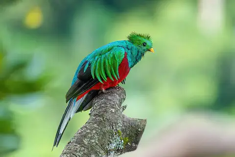
The resplendent quetzal, with glittering green feathers and a very long tail, is Guatemala's national bird, and the country's money is even named after it. A reserve for quetzals has been set aside in the mountains near Cobán.
The lowland forests have the richest wildlife: deer, monkeys, peccaries, tapirs, ocelots and jaguars, though many are becoming rare. Crocodiles, iguanas and many snakes live here too. The quetzal in the photo was photographed in Costa Rica.
Britannica notes that the richest animal life is in the lowland forests, though deer, monkeys, peccaries, tapirs, ocelots and jaguars are increasingly rare; reptiles include many snakes, crocodiles and iguanas. The rainforest birdlife is exuberant, led by the quetzal (Pharomachrus), the national bird, for which a reserve has been set aside in the sierras near Cobán; the currency, the quetzal, shares its name.
In the volcanic highlands, pine, fir and oak forest has largely been destroyed except on the highest slopes, and the Pacific plain has mostly been cleared. The quetzal photo is from Los Quetzales National Park, Costa Rica, and the other animal photos are from elsewhere.
Maya peoples and woven colors
About two in five people in Guatemala are Maya.
Many women wear colorful woven blouses called huipils. Cooks make corn tamales and stuffed peppers.
About two-fifths of Guatemalans are Maya, from groups such as the Mam, K'iche', Kaqchikel and Q'eqchi'. Most others are Ladinos, with both Spanish and Maya ancestors, and there are smaller Xinca and Garifuna communities. Spanish is official, and the 1996 peace agreement was translated into more than 20 Mayan languages.
In many villages, people still wear colorful handwoven clothes; each community has its own patterns. Food mixes Maya and Spanish traditions, from tamales of fresh corn to stuffed peppers. Independence Day, September 15, is celebrated with fireworks, parades and football.
Britannica divides the population culturally into Ladinos (mixed Hispanic-Maya, one-half to three-fifths) and Maya (about two-fifths), with smaller Xinca and Garífuna groups. The largest Maya groups are the Mam in the west, the K'iche' north and west of Lake Atitlán, the Kaqchikel from Atitlán to Guatemala City and the Q'eqchi' near Lake Izabal. Since the late 20th century there has been a strong push to promote Maya identity and languages.
Handwoven textiles and costumes unique to each community are the best-known crafts, and huipils are sold at fairs. Miguel Ángel Asturias won the 1967 Nobel Prize for Literature, and the K'iche' activist Rigoberta Menchú the 1992 Nobel Peace Prize. Cultural institutions include the Ixchel Museum of Indian Attire in Guatemala City.
From the Maya to the peace accords
Long ago, the Maya built great stone cities.
Later, Spain ruled the land. In 1821 Guatemala became free from Spain.
The Maya built cities such as Tikal and Quiriguá more than a thousand years ago, carving stone monuments like the one in the photo. In the 1500s Spain conquered the region, and Antigua became the capital of a large Spanish territory.
Guatemala became independent from Spain in 1821. For much of the 1900s, military governments ruled, and a long civil war lasted from the 1960s until peace agreements were signed in 1996. Since then, Guatemalans have voted in regular elections.
Tikal was inhabited from the 6th century BCE to the 10th century CE. Spain conquered the region in the 16th century and ruled from Antigua, capital of the Captaincy-General of Guatemala, until the 1773 earthquake moved the capital to the new Guatemala City. Independence from Spain came in 1821; September 15 is the national day.
Britannica describes a long history of authoritarian and military rule until democratic government in 1985. From the early 1960s, governments faced guerrilla opposition in a civil war that lasted 36 years, during which Indigenous communities suffered greatly, until peace accords were signed in December 1996. Rigoberta Menchú's 1992 Nobel Peace Prize drew world attention to those struggles. Elections have been held regularly since.

Guatemala on the map
Find Guatemala on the globe.
Look below Mexico, where North America gets thin. Guatemala is the country next to Mexico.
Guatemala is in Central America. Mexico is to the north and west, Belize to the northeast, Honduras to the east and El Salvador to the southeast. The Pacific Ocean is to the south, and a short coast faces the Caribbean's Gulf of Honduras.
The Petén, in the north, pokes up into the Yucatán Peninsula, shared with Mexico and Belize.
Britannica bounds Guatemala by Mexico (north and west), Belize and the Gulf of Honduras (northeast), Honduras (east), El Salvador (southeast) and the Pacific (south). Wikidata gives an area of 108,889 km².
Guatemala has a long-standing claim to Belizean territory, which remains unresolved; PlayOwl's globe follows Natural Earth's de facto border.
- Volcanoes in the southern chain
- 27, over about 300 km
- Highest point
- Tajumulco, about 4,220 m
- Maya share of the population
- about two-fifths
- People (2018 census, adjusted by INE)
- 16,346,950
Amazing facts
-
Guatemala's money is named after a bird.
Guatemala's money is called the quetzal, the same name as its national bird.
The quetzal (Pharomachrus) is Guatemala's national bird, and the currency bears its name.
-
Three of Guatemala's volcanoes are always active.
Fuego, Pacaya and Santiaguito are active all the time.
Britannica lists three continuously active volcanoes: Santiaguito, Fuego (3,835 m) and Pacaya (2,552 m).
-
People lived in Tikal for more than 1,500 years.
The Maya city of Tikal was lived in from about 600 BCE to about 900 CE.
UNESCO dates Tikal's occupation from the 6th century BCE to the 10th century CE.
-
An earthquake made Guatemala move its capital.
After an earthquake destroyed Antigua in 1773, Guatemala City was founded as the new capital in 1776.
Antigua was largely destroyed by the 1773 earthquake; Guatemala City replaced it as capital in 1776.
Words to know
- volcano
- an opening in Earth's crust where melted rock, ash and gas come out
- huipil
- a colorful embroidered blouse worn by many Maya women
- Ladino
- in Guatemala, a person of mixed Spanish and Maya origin who follows Spanish-speaking ways
- census
- an official count of all the people in a country
- plaza
- a large open square in a town or city
- peace accord
- an agreement that ends a war
Discovery challenge
-
Which ancient people built Tikal?
Which civilization built the great city of Tikal?
Tikal is one of the major sites of which civilization?
- The Maya
- The Romans
- The Vikings
Show the answer
The Maya
The Maya built Tikal.
The Maya, whose descendants still live in Guatemala.
Maya civilization; Tikal was inhabited from the 6th century BCE to the 10th century CE.
-
What is Guatemala's national bird?
Which shiny green bird is Guatemala's national bird?
Which bird, Pharomachrus, gives its name to Guatemala's currency?
- The quetzal
- The penguin
- The ostrich
Show the answer
The quetzal
The quetzal is the national bird.
The resplendent quetzal, which also names Guatemala's money.
The quetzal.
-
How many volcanoes stand in a row in southern Guatemala?
How many volcanoes make up the chain across southern Guatemala?
According to Britannica, how many volcanoes form the 300-km southern chain?
- 3
- 27
- 200
Show the answer
27
There are 27 volcanoes in the row.
27 volcanoes, three of them always active.
27, from Tacaná on the Mexican border into El Salvador.
-
Why did Guatemala get a new capital long ago?
Why was Guatemala City founded in 1776?
What led to the founding of Guatemala City as capital in 1776?
- A flood
- An earthquake destroyed Antigua
- A big snowstorm
Show the answer
An earthquake destroyed Antigua
An earthquake broke the old capital.
An earthquake destroyed much of Antigua in 1773.
The 1773 earthquake that largely destroyed Antigua.
Places to discover in Guatemala
-
 Watch
City
Guatemala City
Guatemala City is the capital of Guatemala, in Central America. It was founded in 1776 in a basin among the mountains, about 1,500 meters above sea level, after earthquakes damaged the old capital. Today it is the country's most important city, and its census count in 2018 was 923,392 people.
-
Watch
Landmark
Quiriguá
Quiriguá is the ruin of a Maya city in eastern Guatemala, near the Motagua River. People lived there from about 200 to 900 CE. It is known for its tall carved stones, called stelae, and large carved boulders, most of them made in the 8th century.
-
Watch
Landmark
Tikal
Tikal was one of the great cities of the ancient Maya, in the forests of northern Guatemala. People lived here for well over a thousand years, until about the year 900, and built steep temple pyramids, palaces and wide plazas. Today it is a national park, protected for both its ruins and its wildlife.
Animals of Guatemala
-
Watch
Animal
Resplendent quetzal
The resplendent quetzal is a glittering green and red bird of the cloud forests of southern Mexico and Central America. Males grow long, flowing plumes, up to about 90 centimeters. Quetzals eat mostly small fruits related to avocados, and the bird is the national emblem of Guatemala.
-
 Watch
Animal
Geoffroy's spider monkey
Geoffroy's spider monkey is a big, long-limbed monkey of the forests of southern Mexico and Central America. Its arms are so long that it looks like a spider, and its tail can grip a branch like an extra hand. It eats mostly ripe fruit and lives in a big group that splits up and comes back together.
Explore next
-
Watch
City
Guatemala City
Guatemala City is the capital of Guatemala, in Central America. It was founded in 1776 in a basin among the mountains, about 1,500 meters above sea level, after earthquakes damaged the old capital. Today it is the country's most important city, and its census count in 2018 was 923,392 people.
-
Watch
Landmark
Tikal
Tikal was one of the great cities of the ancient Maya, in the forests of northern Guatemala. People lived here for well over a thousand years, until about the year 900, and built steep temple pyramids, palaces and wide plazas. Today it is a national park, protected for both its ruins and its wildlife.
-
Watch
Landmark
Quiriguá
Quiriguá is the ruin of a Maya city in eastern Guatemala, near the Motagua River. People lived there from about 200 to 900 CE. It is known for its tall carved stones, called stelae, and large carved boulders, most of them made in the 8th century.
-
 Watch
 Country
Mexico
Mexico is a large country in southern North America, between the Pacific Ocean and the Gulf of Mexico. It has smoking volcanoes, ancient cities built by the Maya and other peoples, and about 132 million people, many of them in and around Mexico City.
-
 Watch
 Country
Belize
Belize is on the Caribbean coast of Central America, south of Mexico. Along its shore runs a huge barrier reef, the largest in the Northern Hemisphere, and forests cover about three-fifths of the land. Maya cities once stood here, and today English is the official language. The 2022 census counted about 397,000 people.
-
Watch
Animal
Resplendent quetzal
The resplendent quetzal is a glittering green and red bird of the cloud forests of southern Mexico and Central America. Males grow long, flowing plumes, up to about 90 centimeters. Quetzals eat mostly small fruits related to avocados, and the bird is the national emblem of Guatemala.
-
Watch
Animal
Geoffroy's spider monkey
Geoffroy's spider monkey is a big, long-limbed monkey of the forests of southern Mexico and Central America. Its arms are so long that it looks like a spider, and its tail can grip a branch like an extra hand. It eats mostly ripe fruit and lives in a big group that splits up and comes back together.
-
 Watch
 Country
Honduras
Honduras is a mountainous country in Central America, with the Caribbean Sea to the north and a short Pacific coast to the south. Its forests are home to jaguars and macaws, the Maya city of Copán stands in the west, and about 10.2 million people live there (official 2026 estimate).
For parents & teachers
What children will learn
- Locate Guatemala and describe its volcanic south, central highlands and Petén lowlands.
- Describe Maya heritage in Guatemala, from Tikal to living languages and weaving.
- Explain why a census can miss people and how statisticians adjust for it.
- Outline Guatemala's history from the Maya and Spanish rule to independence and the 1996 peace accords.
Recommended ages: 3 to 17 · About 15 minutes
Talk about it
- Why might a family keep weaving patterns that belong to their own village?
- What could make it hard to count every person in a country?
- Why do you think so many people live near volcanoes in Guatemala?
Try at home or in class
- Weave strips of colored paper into a small mat and invent a pattern that could belong to your family, like a Maya village design.
- Count everyone in your class or family twice on different days, and talk about why the two counts might differ.
Key vocabulary: volcano, huipil, Ladino, census, plaza, peace accord
Where these facts come from
- Wikidata , Wikimedia Foundation (CC0 1.0)
- Natural Earth vector data , Natural Earth (NACIS) (Public domain)
- UNESCO World Heritage List , UNESCO World Heritage Centre (Linked as a reference; site facts come from Wikidata)
- Guatemala (introduction, name, land, relief) , Encyclopaedia Britannica
- Guatemala: Climate (plant and animal life, ethnic groups, languages) , Encyclopaedia Britannica
- Guatemala: Daily life and social customs (food, arts, institutions) , Encyclopaedia Britannica
- Archaeological Park and Ruins of Quirigua , UNESCO World Heritage Centre
- Tikal National Park , UNESCO World Heritage Centre
- Antigua Guatemala , UNESCO World Heritage Centre
- Según INE, somos 14 millones 901 mil 286 guatemaltecos (2018 census results) , La Hora
- INE actualiza Censo 2018: somos 16.3 millones de habitantes , Emisoras Unidas
- PlayOwl region table, version 1 , PlayOwl (PlayOwl original data)
- flag-icons 7.5.0 , Panayiotis Lipiridis and contributors (MIT)
- Wikimedia Commons , Wikimedia Foundation (Per file (public domain, CC0, CC BY or CC BY-SA); see each media record)
Checked, not yet human-reviewed. Last updated November 1, 2026. Spotted a mistake? Tell us.
Picture credits
- Photo: Mundo Maya, CC BY-SA 4.0, via Wikimedia Commons · source · license
- Photo: Chad Davis, CC BY-SA 2.0, via Wikimedia Commons · source · license
- Photo: Bruno Rijsman, CC BY-SA 2.0, via Wikimedia Commons · source · license
- Photo: Giles Laurent, CC BY-SA 4.0, via Wikimedia Commons · source · license
- Photo: S2RD2, CC BY 2.0, via Wikimedia Commons · source · license
- Photo: Simon Burchell, CC BY-SA 4.0, via Wikimedia Commons · source · license
- Photo: Thiagomarcelcampi, CC BY-SA 4.0, via Wikimedia Commons · source · license
- Photo: Charles J. Sharp, CC BY-SA 4.0, via Wikimedia Commons · source · license