
 Country
North America
Mexico
Mexico is a country in North America. It has tall volcanoes, old stone pyramids, deserts and orange monarch butterflies.
Mexico is a large country in southern North America, between the Pacific Ocean and the Gulf of Mexico. It has smoking volcanoes, ancient cities built by the Maya and other peoples, and about 132 million people, many of them in and around Mexico City.
Mexico, officially the United Mexican States, is a federal republic of 31 states and Mexico City on the western edge of the North American Plate, part of the Pacific Ring of Fire. Its 2020 census counted 126,014,024 people, more than half of them in the center of the country, and about 7.4 million people speak one of 68 Indigenous languages.
Photo: Jakub Hejtmánek at Czech Wikipedia, CC BY-SA 3.0, via Wikimedia Commons
Discover Mexico
Mexico is a big country in North America.
The United States is to the north. The sea is on both sides. Mexico has tall volcanoes and dry deserts. The capital city is Mexico City.
Mexico is a country in southern North America. The United States lies along its whole northern border, the Pacific Ocean is to the west and south, and the Gulf of Mexico and the Caribbean Sea are to the east. Guatemala and Belize are its neighbors to the southeast.
Mexico is made of 31 states plus Mexico City, its capital. The land has high plateaus, long mountain ranges, volcanoes, dry deserts in the north and a warm, tropical south. About 132 million people lived there in 2025, and Mexico has more Spanish speakers than any other country.
Mexico is the third-largest country in Latin America, after Brazil and Argentina, covering about 1,964,375 square kilometers. Roughly triangular, it stretches more than 3,000 km from northwest to southeast; its width shrinks to less than 217 km at the Isthmus of Tehuantepec and exceeds 1,900 km in the north. Britannica divides it into nine physiographic regions, from the arid Baja California peninsula to the limestone Yucatán Peninsula.
The country's 2020 census counted 126,014,024 residents, and the World Bank estimates 131.9 million for 2025. More than half of the people live in the center of the country, while large parts of the dry north and the tropical south are thinly settled; nearly four-fifths live in urban areas. Mexico has the world's largest population of Spanish speakers, about two and a half times that of Spain or Colombia.
Cities and ancient places
Mexico City is the biggest city in Mexico.
Long ago, it was a city on islands in a lake. Chichén Itzá has a tall stone pyramid with steps. Teotihuacan has two giant pyramids.
Mexico City is the capital, and about 9.2 million people lived there in 2020. It was built by the Spanish in the 1500s on the ruins of Tenochtitlan, the old Aztec capital, which had stood on islands in Lake Texcoco. South of the center, at Xochimilco, canals and farming islands still show how the Aztec people built on the lake.
About 50 kilometers away is Teotihuacan, a city built between the 1st and 7th centuries with the huge Pyramids of the Sun and the Moon. In the Yucatán, Chichén Itzá was a great Maya city for nearly 1,000 years; its stepped pyramid is called El Castillo.
Tenochtitlan was founded about 1325 on two small islands in the marshes of Lake Texcoco and grew, through artificial islands, to more than 13 km² linked to the shore by causeways; Britannica estimates its 1519 population at about 400,000. It was destroyed by Spanish forces under Hernán Cortés in 1521, and Mexico City was built on its ruins. UNESCO's listing of the historic center and Xochimilco (1987) notes five identified Aztec temple ruins, a cathedral that is the largest on the continent, and Xochimilco's canals and artificial islands, 28 km south.
Teotihuacan, about 50 km northeast of Mexico City, was built between the 1st and 7th centuries AD and laid out on geometric principles; its influence spread across Mesoamerica. Chichén Itzá (inscribed 1988) was one of the greatest Maya centers of the Yucatán over a history of nearly 1,000 years, combining Maya building techniques with elements from central Mexico; El Castillo, the Warriors' Temple and the round observatory El Caracol survive. At Monte Albán, near Oaxaca, Olmecs, Zapotecs and Mixtecs lived over some 1,500 years.

Volcanoes, mountains and deserts
Mexico has many volcanoes.
Popocatépetl is a big one near Mexico City. Its top is often white with snow. One volcano grew out of an open field! Mexico also has dry deserts in the north.
Mexico sits on the edge of the North American Plate, where it meets other plates, so it has many earthquakes and volcanoes. It is part of the Ring of Fire around the Pacific Ocean. Its highest peak, the volcano Citlaltépetl (also called Pico de Orizaba), is more than 5,500 meters tall. Popocatépetl, an active volcano southeast of Mexico City, is 5,465 meters high, and its name means "Smoking Mountain" in Nahuatl.
In 1943, the ground in an open field in Michoacán began to erupt. The eruption lasted nine years and built a new volcano, Paricutín. In the northwest, the Baja California peninsula is a long strip of very dry land.
Mexico lies on the western, leading edge of the North American Plate; its interaction with the Pacific, Cocos and Caribbean plates causes frequent severe earthquakes and built much of the rugged south. Its volcanoes, part of the circum-Pacific Ring of Fire, are geologically young, from the Paleogene and Neogene periods. Popocatépetl, a symmetrical, snowcapped cone on the border of the states of México and Puebla, rises to 5,465 m, second only to Pico de Orizaba (Citlaltépetl), which Britannica gives as 5,610 m.
Paricutín, in western Michoacán, formed during a nine-year eruption that began on February 20, 1943, in an open field after weeks of earthquakes and ended in 1952; Britannica calls it one of the youngest volcanoes on Earth. The Baja California peninsula, nearly 1,300 km long and seldom more than 160 km wide, is extremely arid, and the Sonoran and Chihuahuan deserts spread across the north.

Animals of Mexico
The axolotl lives in the water near Mexico City.
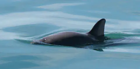
It has frilly gills on its head. Every autumn, millions of orange butterflies fly to Mexico's mountain forests. A small porpoise called the vaquita lives in the sea in the northwest.
The axolotl is a salamander that stays like a youngster all its life. It keeps its feathery gills, its tail and its fin, and lives its whole life in water. Wild axolotls now live only in a few spots in the south of Mexico City, and they are critically endangered.
Every autumn, millions of monarch butterflies from many parts of North America fly to forests in the mountains about 100 kilometers northwest of Mexico City. They cluster so thickly that tree branches bend under their weight. In the northern Gulf of California lives the vaquita, a small, shy porpoise. Only 7 to 10 were seen in 2025.
The axolotl (Ambystoma mexicanum) is neotenic: it keeps larval traits such as external gills, a tail fin and no movable eyelids into adulthood and stays aquatic, even though it develops working lungs. Native to Lakes Xochimilco and Chalco in the Basin of Mexico, it now survives in just three isolated sites in southern Mexico City and is Critically Endangered by pollution, habitat loss and non-native species.
The Monarch Butterfly Biosphere Reserve, 56,259 hectares of forested mountains about 100 km northwest of Mexico City, was inscribed by UNESCO in 2008. Each autumn millions, perhaps a billion, monarchs gather there; in spring they begin a migration to eastern Canada and back over four generations. The vaquita (Phocoena sinus), the most endangered marine mammal, lives only in the northern Gulf of California. NOAA says entanglement in illegal gillnets is driving it toward extinction, and 2025 surveys by the Mexican government and Sea Shepherd reported sightings of between 7 and 10 individuals, including new calves.

People, languages and food
About 132 million people live in Mexico.
Most people speak Spanish. Millions of people also speak Indigenous languages, such as Nahuatl and Maya. Corn tortillas are part of many meals.
Most people in Mexico speak Spanish, and Mexico has more Spanish speakers than any other country. More than 7 million people also speak one of 68 Indigenous languages. The most common are Nahuatl, Maya and Tseltal. Most people live in cities, and more than half live in the middle of the country.
Traditional Mexican cooking is built on corn, beans and chili, with tomatoes, squash, avocados, cocoa and vanilla. Corn is cooked with lime, a method called nixtamalization, and made into everyday tortillas and tamales. UNESCO lists this cooking tradition as Intangible Cultural Heritage, a living tradition worth protecting.
The 2020 census counted 126,014,024 people (51.2 percent women), with a median age of 29. Spanish is the official language. That year 7,364,645 people aged three and over, 6.1 percent of the population, spoke an Indigenous language; INEGI counts 68 Indigenous languages, led by Nahuatl (22.4 percent of speakers), Maya (10.5) and Tseltal (8.0), and about 12 in 100 speakers do not speak Spanish. Another 2 percent of people (2,576,213) identified as Afro-Mexican or of African descent.
UNESCO inscribed traditional Mexican cuisine on its Intangible Cultural Heritage list in 2010, using Michoacán's community cooks as its example. It rests on corn, beans and chili; farming methods such as the milpa and chinampas (built-up farming islands in lakes); and nixtamalization, cooking maize with lime, which raises its nutritional value. Tortillas and tamales are everyday foods and part of Day of the Dead offerings.

Ancient cities and a new nation
People have lived in Mexico for a very, very long time.
Long ago, they built big cities with stone pyramids. Later, people from Spain ruled for 300 years. Then Mexico became its own country.
Many peoples built great cities in Mexico long ago. Teotihuacan was built between the 1st and 7th centuries. Maya cities such as Chichén Itzá grew in the south. Around 1325, the Aztec people founded Tenochtitlan on islands in a lake.
In 1521, Spanish soldiers led by Hernán Cortés destroyed Tenochtitlan, and Spain ruled Mexico for about 300 years. On September 16, 1810, a priest named Miguel Hidalgo called for an end to Spanish rule; the date is now Mexico's Independence Day. Mexico became independent in 1821.
Mexico's past includes a long succession of civilizations: at Monte Albán, Olmecs, Zapotecs and Mixtecs lived over 1,500 years; Teotihuacan flourished from the 1st to 7th centuries AD; and Chichén Itzá was a major Maya center for nearly a millennium. The Aztec capital Tenochtitlan, founded around 1325, was the Aztec seat by the late 15th century and, with about 400,000 people in 1519, the largest residential concentration in Mesoamerican history.
Spanish forces under Hernán Cortés destroyed it in 1521, and Spain built Mexico City on its ruins. On September 16, 1810, now celebrated as Independence Day, Miguel Hidalgo y Costilla issued the Grito de Dolores, calling for an end to Spanish rule, racial equality and land redistribution, which launched the War of Independence. Separation from Spain is dated to August 24, 1821. Britannica describes the Mexican Revolution of 1910–20 as a long struggle among shifting factions that ended a 30-year dictatorship and established a constitutional republic; the constitution of 1917, drafted during it and amended several times since, is still the country's fundamental law. Today Mexico is a federal republic with a two-house legislature.

Mexico on the map
Find Mexico on the globe.
It is south of the United States. The Pacific Ocean is on one side. The Gulf of Mexico is on the other side. Mexico gets thinner toward the south.
Mexico is shaped a bit like a triangle, wide in the north and narrow in the south. It shares its whole northern border with the United States, and Guatemala and Belize are to the southeast.
The Pacific Ocean washes its west and south coasts. On the east are the Gulf of Mexico and the Caribbean Sea. Two peninsulas stick out from the mainland: long, thin Baja California in the northwest and the flat Yucatán Peninsula in the southeast.
Mexico shares a border with the United States along its entire northern extent and is bounded by the Pacific Ocean to the west and south, by the Gulf of Mexico and the Caribbean Sea to the east, and by Guatemala and Belize to the southeast. It also administers islands such as the Tres Marías in the Pacific and Cozumel and Mujeres off the Yucatán coast.
Including these islands, the roughly triangular country covers about three times the area of Texas. It runs more than 3,000 km from northwest to southeast, narrowing to less than 217 km at the Isthmus of Tehuantepec. The Baja California peninsula, nearly 1,300 km long, is separated from the mainland by the Gulf of California, also called the Sea of Cortez.
- Length, northwest to southeast
- more than 3,000 km
- Narrowest point
- less than 217 km, at the Isthmus of Tehuantepec
- Area
- 1,964,375 km²
- Land neighbors
- United States, Guatemala and Belize
Amazing facts
-
A volcano in Mexico grew out of an open field.
In 1943, an open field in Michoacán started to erupt, and over nine years it built a brand-new volcano, Paricutín.
Paricutín formed in an eruption from February 20, 1943, to 1952 that began in an open field; Britannica calls it one of the youngest volcanoes on Earth.
-
So many butterflies land on the trees that the branches bend.
Each autumn, millions of monarch butterflies cluster in Mexico's mountain forests, so thick that branches bend under their weight.
UNESCO says millions, perhaps a billion, monarchs return each autumn to the 56,259-hectare biosphere reserve, and four generations are born and die during the round trip to eastern Canada.
-
Popocatépetl's name means Smoking Mountain.
The volcano Popocatépetl gets its name from the Nahuatl language. It means "Smoking Mountain."
Popocatépetl, Nahuatl for "Smoking Mountain," is a 5,465 m snowcapped cone 72 km southeast of Mexico City.
-
Mexico City is built where an old city stood on islands in a lake.
The Aztec capital Tenochtitlan stood on islands in Lake Texcoco, and Mexico City was built on its ruins.
Tenochtitlan began on two small islands in Lake Texcoco and grew to more than 13 km² through artificial islands linked to the shore by causeways.
-
Axolotls keep their baby gills when they grow up.
Unlike most salamanders, axolotls keep their feathery gills and live in water all their lives.
Axolotls are neotenic: they keep external gills, a tail fin and other larval traits into adulthood, though they also develop working lungs.
Words to know
- volcano
- an opening in Earth's crust where melted rock, ash and gas come out
- tectonic plate
- one of the giant, slowly moving pieces of Earth's outer shell
- peninsula
- a piece of land with water on three sides
- pyramid
- a large building with a wide base and sides that slope up to a point or a flat top
- Indigenous
- describes the first peoples known to have lived in a place
- migration
- a long journey animals make at the same time each year
- nixtamalization
- a way of cooking corn with lime that makes it more nourishing
Discovery challenge
-
What is the capital city of Mexico?
Which city is the capital of Mexico?
Which capital was built in the 16th century on the ruins of Tenochtitlan?
- Cancún
- Mexico City
- Guadalajara
Show the answer
Mexico City
Mexico City is the capital.
Mexico City is the capital. It was built on the ruins of the Aztec city Tenochtitlan.
The Spanish built Mexico City in the 16th century on the ruins of Tenochtitlan, destroyed in 1521.
-
What are tortillas made from?
Traditional Mexican cooking is built on beans, chili and which other plant?
UNESCO says traditional Mexican cuisine is founded on beans, chili and which crop, prepared by nixtamalization?
- Corn
- Wheat
- Potatoes
Show the answer
Corn
Tortillas are made from corn.
Corn, beans and chili are the base of traditional Mexican cooking, and tortillas are made of corn.
Corn (maize), beans and chili form the base; nixtamalization, cooking maize with lime, raises its nutritional value.
-
Which volcano grew out of an open field?
Which volcano began erupting in an open field in 1943?
Which Michoacán volcano formed in a nine-year eruption, 1943 to 1952?
- Popocatépetl
- Citlaltépetl
- Paricutín
Show the answer
Paricutín
Paricutín grew out of a field.
Paricutín began in an open field in 1943 and kept erupting for nine years.
Paricutín began erupting on February 20, 1943, after weeks of earthquakes and stopped in 1952; it is one of the youngest volcanoes on Earth.
-
Where do monarch butterflies go in Mexico in the autumn?
Where in Mexico do millions of monarch butterflies spend the winter?
Where is the UNESCO-listed site where monarchs from wide areas of North America overwinter?
- Forests in the mountains
- Deserts of Baja California
- Beaches of Cancún
Show the answer
Forests in the mountains
They go to forests in the mountains.
They gather in mountain forests about 100 kilometers northwest of Mexico City.
The Monarch Butterfly Biosphere Reserve covers 56,259 ha of rugged forested mountains about 100 km northwest of Mexico City.
-
Which animal keeps its frilly gills all its life?
Which Mexican animal keeps its feathery gills and lives in water all its life?
Which neotenic salamander survives in only three sites in southern Mexico City?
- Vaquita
- Axolotl
- Monarch butterfly
Show the answer
Axolotl
The axolotl keeps its frilly gills.
The axolotl stays like a youngster, with gills, a tail and a fin, all its life.
Ambystoma mexicanum keeps larval traits into adulthood and is Critically Endangered in its last wild sites.
Places to discover in Mexico
-
 Watch
City
Mexico City
Mexico City, the capital of Mexico, sits 2,240 meters high in the Valley of Mexico. It was founded in 1521 on the ruins of Tenochtitlan, the Aztec capital that stood on an island in a lake. About 9.2 million people lived there in 2020, and more than 23 million in the wider metropolitan area.
-
Watch
Landmark
Chichén Itzá
Chichén Itzá is the ruin of a great Maya city on the Yucatán Peninsula in Mexico. Its people built pyramids, a huge ball court and a round building for watching the sky. Its most famous pyramid, El Castillo, has 365 steps, as many as the days in a year.
-
 Watch
Landmark
Teotihuacan
Teotihuacan, about 50 kilometers northeast of Mexico City, was a huge city almost 2,000 years ago. A long, straight avenue runs through it, lined by giant pyramids, including the Pyramid of the Sun and the Pyramid of the Moon. Around 500 CE, it was one of the largest cities in the world.
Animals of Mexico
-
Watch
3D
Animal
Axolotl
The axolotl is a salamander from the canals and lakes of Mexico City. Unlike most amphibians, it keeps its baby features, such as feathery gills and a fin, its whole life. It can regrow lost legs and even parts of its heart, but in the wild it is critically endangered.
-
 Watch
3D
Animal
Monarch butterfly
The monarch butterfly is famous for its bright orange wings and its amazing journey. Each fall, monarchs from eastern North America fly up to 3,000 miles to mountain forests in Mexico, where they spend the winter clustered together on fir trees. Their caterpillars eat only milkweed, which makes them taste bad to predators.
-
 Watch
Animal
Vaquita
The vaquita is one of the smallest members of the whale, dolphin and porpoise family, and the most endangered marine mammal in the world. It lives only in the northern Gulf of California in Mexico. In 2025, survey teams saw between 7 and 10 different vaquitas and at least one new calf, and many people are working to keep them safe from fishing nets.
-
 Watch
Animal
Western diamondback rattlesnake
The western diamondback rattlesnake is a heavy-bodied snake of the deserts and dry grasslands of the southwestern United States and Mexico. It has diamond patterns, a black-and-white striped tail and a rattle that buzzes as a warning. It is venomous, so it is a snake to admire from far away, but it would much rather hide or slip away than meet a person.
-
 Watch
Animal
Ocelot
The ocelot is a medium-sized wild cat of the Americas, from southern Texas to northern Argentina. Its golden coat has chains of dark-edged spots, and no two ocelots look alike. It hunts mostly at night, catching mice, rats, lizards and birds, and it needs thick plants to hide in.
-
 Watch
3D
Animal
Great white shark
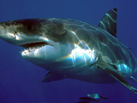
The great white shark is the largest of the mackerel sharks: a strong, torpedo-shaped fish with a gray back and a white belly. It hunts fish, seals and sea lions, and it is partly warm-blooded, which helps it stay active in cool water.
-
 Watch
3D
Animal
Spotted eagle ray
The spotted eagle ray is a ray that 'flies' through warm Atlantic waters by flapping its wide, wing-like fins. Its dark back is covered in white spots, its tail is long and whip-like, and its snout looks a bit like a duck's bill, which it uses to dig for clams and other shellfish.
-
 Watch
Animal
Gray whale
The gray whale is a baleen whale of the North Pacific Ocean. It sucks up mud from the seafloor to catch tiny animals, and it makes one of the longest yearly journeys of any mammal: about 16,000 kilometers there and back between Arctic feeding seas and shallow lagoons in Mexico.
-
 Watch
Animal
Northern mockingbird
The northern mockingbird is a slim gray songbird famous for copying sounds. It sings long strings of phrases, many borrowed from other birds, and sometimes sings all night. It lives in towns, farms and brushy places across the United States, Mexico and the Caribbean.
-
 Watch
3D
Animal
Keel-billed toucan
The keel-billed toucan lives in the forests of southern Mexico, Central America and northern South America. Its huge, colorful bill can be a third of its whole length, yet it is light, and the bird uses it to pick fruit from thin branches.
-
 Watch
Animal
Common blue morpho
The common blue morpho is a large butterfly of the forests of Mexico, Central America and South America. The tops of its wings flash bright blue, but the undersides are brown with big eyespots, which camouflage it when it lands with its wings closed. Adults sip juice from rotting fruit instead of nectar.
-
 Watch
3D
Animal
Eastern box turtle
The eastern box turtle is a small land turtle of eastern North America with a high, domed shell splashed with yellow and orange. A hinge on the bottom shell lets it close up almost completely, like a box with a lid. It eats mushrooms, berries, worms and slugs and can live for decades.
Explore next
-
Watch
City
Mexico City
Mexico City, the capital of Mexico, sits 2,240 meters high in the Valley of Mexico. It was founded in 1521 on the ruins of Tenochtitlan, the Aztec capital that stood on an island in a lake. About 9.2 million people lived there in 2020, and more than 23 million in the wider metropolitan area.
-
Watch
Landmark
Chichén Itzá
Chichén Itzá is the ruin of a great Maya city on the Yucatán Peninsula in Mexico. Its people built pyramids, a huge ball court and a round building for watching the sky. Its most famous pyramid, El Castillo, has 365 steps, as many as the days in a year.
-
Watch
Landmark
Teotihuacan
Teotihuacan, about 50 kilometers northeast of Mexico City, was a huge city almost 2,000 years ago. A long, straight avenue runs through it, lined by giant pyramids, including the Pyramid of the Sun and the Pyramid of the Moon. Around 500 CE, it was one of the largest cities in the world.
-
Watch
3D
Animal
Axolotl
The axolotl is a salamander from the canals and lakes of Mexico City. Unlike most amphibians, it keeps its baby features, such as feathery gills and a fin, its whole life. It can regrow lost legs and even parts of its heart, but in the wild it is critically endangered.
-
Watch
3D
Animal
Monarch butterfly
The monarch butterfly is famous for its bright orange wings and its amazing journey. Each fall, monarchs from eastern North America fly up to 3,000 miles to mountain forests in Mexico, where they spend the winter clustered together on fir trees. Their caterpillars eat only milkweed, which makes them taste bad to predators.
-
Watch
Animal
Vaquita
The vaquita is one of the smallest members of the whale, dolphin and porpoise family, and the most endangered marine mammal in the world. It lives only in the northern Gulf of California in Mexico. In 2025, survey teams saw between 7 and 10 different vaquitas and at least one new calf, and many people are working to keep them safe from fishing nets.
-
Watch
Life around the world
Floating gardens of Xochimilco, Mexico City
Xochimilco, in the south of Mexico City, still has chinampas: long garden islands built up from lake mud, branches and plants, edged with willow trees and surrounded by canals. Farmers have worked them since Aztec times. UNESCO lists Xochimilco as World Heritage, and FAO named the chinampa system an agricultural heritage site in 2017.
-
Watch
Animal
Western diamondback rattlesnake
The western diamondback rattlesnake is a heavy-bodied snake of the deserts and dry grasslands of the southwestern United States and Mexico. It has diamond patterns, a black-and-white striped tail and a rattle that buzzes as a warning. It is venomous, so it is a snake to admire from far away, but it would much rather hide or slip away than meet a person.
For parents & teachers
What children will learn
- Locate Mexico, its neighbors, its two oceans and its two big peninsulas.
- Explain how meeting tectonic plates give Mexico its volcanoes and earthquakes.
- Describe the many languages, peoples and food traditions of Mexico without treating them as one culture.
- Outline Mexico's history from Teotihuacan and Tenochtitlan to independence in 1821.
Recommended ages: 3 to 17 · About 15 minutes
Talk about it
- Why do you think more than half of Mexico's people live in the center of the country?
- How might people protect an animal like the axolotl that lives in only a few places?
- What foods does your family make from corn, beans or other plants?
Try at home or in class
- On a map, trace the monarch butterflies' trip from eastern Canada to the mountains northwest of Mexico City.
- Use a lump of clay on a tray and push it up slowly from underneath to see how a cone can grow out of flat ground, like Paricutín.
Key vocabulary: volcano, tectonic plate, peninsula, pyramid, Indigenous, migration, nixtamalization
Where these facts come from
- Wikidata , Wikimedia Foundation (CC0 1.0)
- Natural Earth vector data , Natural Earth (NACIS) (Public domain)
- UNESCO World Heritage List , UNESCO World Heritage Centre (Linked as a reference; site facts come from Wikidata)
- En México somos 126 014 024 habitantes: Censo de Población y Vivienda 2020 (Comunicado de prensa 24/21) , INEGI (Instituto Nacional de Estadística y Geografía)
- Estadísticas a propósito del Día Internacional de los Pueblos Indígenas (Comunicado de prensa 430/22) , INEGI (Instituto Nacional de Estadística y Geografía)
- Population, total (SP.POP.TOTL), Mexico , World Bank
- Mexico , Encyclopaedia Britannica
- Mexico: Independence , Encyclopaedia Britannica
- Mexican Revolution , Encyclopaedia Britannica
- Constitution of 1917 , Encyclopaedia Britannica
- Miguel Hidalgo y Costilla , Encyclopaedia Britannica
- Tenochtitlán , Encyclopaedia Britannica
- Popocatépetl , Encyclopaedia Britannica
- Paricutín , Encyclopaedia Britannica
- Historic Centre of Mexico City and Xochimilco , UNESCO World Heritage Centre
- Pre-Hispanic City of Teotihuacan , UNESCO World Heritage Centre
- Pre-Hispanic City of Chichen-Itza , UNESCO World Heritage Centre
- Historic Centre of Oaxaca and Archaeological Site of Monte Albán , UNESCO World Heritage Centre
- Monarch Butterfly Biosphere Reserve , UNESCO World Heritage Centre
- Traditional Mexican cuisine: ancestral, ongoing community culture, the Michoacán paradigm (inscribed 2010) , UNESCO Intangible Cultural Heritage
- Axolotl , San Diego Zoo Wildlife Alliance
- Vaquita , NOAA Fisheries
- Results of the 2025 Vaquita Monitoring Effort (joint release of SEMARNAT, SEMAR, CONANP and Sea Shepherd) , Sea Shepherd Conservation Society
- PlayOwl region table, version 1 , PlayOwl (PlayOwl original data)
- flag-icons 7.5.0 , Panayiotis Lipiridis and contributors (MIT)
- Wikimedia Commons , Wikimedia Foundation (Per file (public domain, CC0, CC BY or CC BY-SA); see each media record)
Checked, not yet human-reviewed. Last updated October 24, 2026. Spotted a mistake? Tell us.
Picture credits
- Photo: Jakub Hejtmánek at Czech Wikipedia, CC BY-SA 3.0, via Wikimedia Commons · source · license
- Photo: Daniel Schwen, CC BY-SA 4.0, via Wikimedia Commons · source · license
- Photo: Karla Yannín Alcázar Quintero (photographer), CC BY 2.0, via Wikimedia Commons · source · license
- Photo: Scazon, CC BY 2.0, via Wikimedia Commons · source · license
- Photo: Apsu09, CC BY 3.0, via Wikimedia Commons · source · license
- Photo: Burkhard Mücke, CC BY-SA 4.0, via Wikimedia Commons · source · license
- Photo: Rhododendrites, CC BY-SA 4.0, via Wikimedia Commons · source · license
- Photo: Paula Olson, NOAA, public domain, via Wikimedia Commons · source
- Photo: Mike Peel, CC BY-SA 4.0, via Wikimedia Commons · source · license
- Photo: Gobierno CDMX, CC0 1.0, via Wikimedia Commons · source · license