
 Country
Asia
Iran
Iran is a big country in Asia with high mountains and dry deserts. Long ago, kings built a city of palaces called Persepolis there.
Iran is a country in southwestern Asia. A high, dry plateau fills its middle, with mountain ranges all around it, and about 92 million people (2025) live there. Long ago it was called Persia, and its capital today is Tehran.
Iran is a mountainous, arid and ethnically diverse country of southwestern Asia, built around a high interior plateau ringed by the Alborz and Zagros mountains. Traditionally known as Persia, it traces a continuous culture to the Achaemenian period, which began in 550 BCE. About 92.4 million people lived there in 2025 (World Bank), most of them around the edges of the plateau.
Photo: Mshayati, CC BY-SA 4.0, via Wikimedia Commons
Discover Iran
Iran is a big country in Asia.
It has tall mountains and dry, sandy deserts. A big sea lies to the north. More sea water lies to the south. The capital city is called Tehran.
Iran is a country in southwestern Asia. Its middle is a high, dry plateau, a wide area of flat land raised far above the sea, and huge mountain ranges stand all around it. Most people live around the edges of this plateau, where there is more water.
For a very long time the land was called Persia, and many old palaces, gardens and bazaars still stand there. About 92 million people lived in Iran in 2025. Its capital is Tehran, a huge city at the foot of the Alborz Mountains.
Iran covers about 1,648,000 square kilometers of southwestern Asia. Britannica describes it as mountainous, arid and ethnically diverse: a central desert plateau, ringed on all sides by high ranges that are crossed only through high passes, with most of the population living on the plateau's edges. Most of the country lies above 460 meters, and one-sixth of it is higher than 1,980 meters.
The region was traditionally known as Persia, with a distinctive culture dating to the Achaemenian period, which began in 550 BCE. The World Bank estimated its population at 92,417,681 in 2025. The capital, Tehran, is a sprawling city at the southern foot of the Alborz Mountains, and Isfahan and Shiraz combine modern buildings with landmarks from the past.
Cities and famous places
Tehran is the biggest city in Iran.
Snowy mountains rise behind it. Isfahan has a giant square with gardens and blue domes. Old palaces and a busy covered market are famous too.
Tehran is Iran's capital and largest city. It became the capital more than 200 years ago and grew from a small city into a giant one, with about 8.7 million people in the city in 2016. Isfahan, about 400 kilometers to the south, is famous for its buildings.
In Isfahan, Naqsh-e Jahan Square was built in the early 1600s, with two-story arcades on every side and mosques with tiled domes. In Tabriz, in the northwest, a huge covered bazaar made of brick buildings was already famous more than 700 years ago, and UNESCO calls it one of the most important trading centers on the Silk Road.
Tehran, the capital since Āghā Moḥammad Khān established it there more than 200 years ago, had 8,693,706 people in the city in 2016 and sits in an urban region of about 14 million (Britannica). Isfahan, about 400 km south, is the second most important city and is famed for its architecture.
Naqsh-e Jahan Square in Isfahan was built by Shah Abbas I at the start of the 17th century and inscribed by UNESCO in 1979; two-story arcades link the Royal Mosque, the Mosque of Sheykh Lotfollah, the Qaysariyyeh portico and a 15th-century Timurid palace. Tabriz's historic bazaar, a World Heritage Site since 2010, is a series of interconnected, covered brick structures; UNESCO calls it one of the most important commercial centers on the Silk Road. The desert city of Yazd, 270 km southeast of Isfahan, keeps its earthen houses, bazaars and bathhouses, and water reaches it through a qanat system (inscribed 2017).

Mountains, deserts and seas
Iran has very high mountains.
The tallest one is called Damavand. Its top is covered in snow. In the middle of Iran there are big, dry deserts. Near the northern sea, it is green and rainy.
Two great mountain ranges shape Iran. The Alborz Mountains run along the Caspian Sea in the north, and the Zagros Mountains stretch from the northwest to the Strait of Hormuz in the south. The highest peak, snowy Mount Damavand, is an old volcano more than 5,600 meters tall that last erupted about 7,300 years ago.
Inside the mountain ring lie two big deserts, the Dasht-e Kavir and the Dasht-e Lut, where low basins dry out into salt flats. On the narrow coast by the Caspian Sea, the mountains catch the rain, and forests, swamps and rice fields grow. Earthquakes happen often in Iran.
Massive, eroded ranges surround Iran's high interior basin: the Alborz along the south shore of the Caspian and the Zagros, a band of parallel ridges up to 200 km wide that runs northwest to southeast toward the Strait of Hormuz. Mount Damavand, an extinct volcano about 68 km northeast of Tehran, is the highest point; Britannica gives estimates from about 5,610 to 5,670 m and dates its latest eruption to about 7,300 years ago. Earthquakes are frequent and violent; in 2003 one leveled the old town of Bam.
The plateau's floor holds the Dasht-e Kavir and Dasht-e Lut, where evaporation leaves salt wastes called kavirs. UNESCO inscribed the Lut Desert in 2016 for its yardangs, massive corrugated ridges carved by strong winds between June and October. Rainfall ranges from under 50 mm a year in the southeast to about 1,980 mm by the Caspian, averaging about 400 mm; average summer daytime temperatures in Abadan top 43 °C, while winter highs in Tabriz barely reach freezing.

Animals of Iran
Leopards and brown bears live in Iran's green forests.
Wild goats called ibex live in the mountains. A few cheetahs live in Iran too. Fish called sturgeon swim in the Caspian Sea.
Iran's wooded mountains are home to leopards, bears, wild boars, wild goats called ibex, and gazelles. Wild asses live in the salty deserts, and partridges live in most parts of the country.
In the old forests along the Caspian Sea, scientists have recorded 180 kinds of birds and 58 kinds of mammals, including leopards, wolves and brown bears. Cheetahs are almost gone from Asia, and the biggest group known there, just a few dozen, lives in northeastern Iran. In the Caspian Sea swim sturgeon, fish whose eggs are made into caviar.
Britannica lists leopards, bears, hyenas, wild boars, ibex, gazelles and mouflons in Iran's wooded mountains, wild asses in the kavirs, and jackals and rabbits in the interior; tigers once lived in the Caspian forests but are now extinct there. Cheetahs are almost extinct in Asia, and the largest confirmed population there, a few dozen animals, lives in northeastern Iran.
The Hyrcanian Forests, a broad-leaved forest belt along the Caspian shared with Azerbaijan, were inscribed by UNESCO in 2019. Their history goes back 25 to 50 million years; they hold more than 3,200 vascular plant species, 180 bird species and 58 mammal species, with full ecosystems that include leopard, wolf and brown bear. Sturgeon are one of 30 fish species in the Caspian and an important export as caviar, and some 200 kinds of fish live in the Persian Gulf. Golestan National Park and the Touran Protected Area are among the country's sanctuaries.

People, languages and food
About 92 million people live in Iran.
Many people speak Persian. Many other languages are spoken too. Rice is a main food. The new year, called Nowruz, begins on the first day of spring.
About 92 million people lived in Iran in 2025. By the 2000s, about three out of four lived in towns and cities. Persian, also called Farsi, is the official language. Many people speak other languages too, such as Azerbaijani, Kurdish, Luri, Arabic and Armenian.
Rice is a main food, simple dishes such as stews called khoresh and kebabs are common, and saffron, mint, lime and pomegranates add flavor. Nowruz, the Persian New Year, falls on the first day of spring, usually March 21. A weeklong holiday follows, and on the 13th day of the new year many people go for a picnic in the countryside. Football is the most popular sport.
The World Bank estimated Iran's population at 92,417,681 in 2025; Britannica notes that after rapid urbanization from the 1960s into the 2000s, about three-fourths of people lived in urban areas, against one-third in the 1950s. Persian (Farsi) is the official language. Roughly three-fourths of Iranians speak an Indo-European language: slightly more than half a dialect of Persian, under one-tenth Kurdish, others Luri or Armenian. Turkic languages, mostly Azerbaijani, are spoken by about one-fourth, and Arabic is the native tongue of a small share.
The vast majority of Iranians are Twelver Shi'i Muslims, the official state religion; Kurds and Turkmen are mostly Sunni, and small Christian, Jewish and Zoroastrian communities live across the country. Persian cooking centers on rice, lamb, vegetables and yogurt, in khoresh stews and kebabs, with saffron as its most distinctive spice. Nowruz, the Persian New Year, runs from the last Wednesday of the old year to a 13th-day countryside picnic. Britannica notes that most towns are supplied by qanats, tunnels that carry water from an underground mountain source down to the town, sometimes for 80 km.

A long history
People have lived in Iran for a very long time.
Long ago, it was called Persia. Kings built palaces of stone. Later, people built big squares, gardens and markets. Many old places still stand today.
About 2,500 years ago, the Achaemenid kings ruled a huge empire from the land that is now Iran. Cyrus the Great built the first capital, Pasargadae, where his stone tomb still stands. In 518 BCE, Darius I began Persepolis, a city of palaces on a giant stone terrace.
In the 600s, Arab armies brought Islam, and later Persian writing grew strong again. In the early 1500s the Safavid rulers came to power, and they built the grand square in Isfahan. In 1925 the Pahlavi family began to rule. In 1979 a revolution ended the rule of the shah, and Iran became an Islamic republic.
Cyrus II the Great founded Pasargadae, the first dynastic capital of the Achaemenid Empire, in the 6th century BCE; UNESCO describes it as the capital of the first great multicultural empire in western Asia, stretching from the eastern Mediterranean and Egypt to the Indus. Darius I began the terrace of Persepolis about 518 BCE. Seleucids, Parthians and Sasanids followed, and the Arab Muslim conquest of the 7th century CE left the most lasting influence. A literary renaissance from the late 8th century revived Persian, now written in Arabic script.
The Safavids made Twelver Shi'ism the official faith in the early 16th century; the Qajars ruled from 1796 and the Pahlavis from 1925. The revolution of 1978–79 ended the monarchy, and after a referendum Iran was declared an Islamic republic on April 1, 1979. In September 1980 Iraq invaded Iran's southwestern province of Khuzestan, and the Iran-Iraq War lasted until a UN cease-fire in August 1988. Under the 1979 constitution, a senior cleric called the leader (rahbar), chosen by the 88-member Assembly of Experts, heads the state; an elected president runs the executive, the 290-member Majles makes laws, and the 12-member Council of Guardians reviews legislation and approves candidates.

Iran on the map
Find Iran on the globe.
It is in Asia, between two seas. One big sea is to the north. A gulf of the ocean is to the south. Seven countries are its neighbors.
Iran is in southwestern Asia. To the north are Azerbaijan, Armenia, Turkmenistan and the Caspian Sea. To the east are Pakistan and Afghanistan, and to the west are Turkey and Iraq.
In the south, Iran's coast runs along the Persian Gulf and the Gulf of Oman. About one-third of Iran's whole border is seacoast, and Iran also has about a dozen islands in the Persian Gulf.
Iran is bounded to the north by Azerbaijan, Armenia, Turkmenistan and the Caspian Sea, to the east by Pakistan and Afghanistan, to the south by the Persian Gulf and the Gulf of Oman, and to the west by Turkey and Iraq. Of its 7,680-km boundary, about one-third is seacoast, and it controls about a dozen islands in the Persian Gulf.
The Caspian, which Britannica calls the world's largest inland body of water, lies about 27 m below sea level; Iran's Caspian strip is about 650 km long and never more than 115 km wide. In the south, the land drops from a 600-meter plateau, backed by a rugged escarpment, to the gulf coasts. The Zagros reach the Strait of Hormuz, and the interior plateau extends into Central Asia.
- Area
- about 1,648,000 km²
- Length of its boundary
- about 7,680 km, about one-third of it seacoast
- Neighbors by land
- 7: Turkey, Armenia, Azerbaijan, Turkmenistan, Afghanistan, Pakistan and Iraq
- Highest point
- Mount Damavand, estimates from about 5,610 to 5,670 m
Amazing facts
-
Some towns in Iran get water through long tunnels under the ground.
Qanats are tunnels that carry water from under the mountains down to towns, and some are as long as 80 kilometers.
A qanat taps an underground mountain water source and channels it through tunnels, sometimes 80 km long, down to the town; towns therefore often sit a short distance from the foot of a mountain.
-
Strong winds carved giant ridges in an Iranian desert.
In the Lut Desert, strong summer winds carry sand that carves huge ridges called yardangs.
Between June and October, strong winds sweep the Lut Desert and erode it on a colossal scale, leaving some of the most spectacular aeolian yardangs on Earth (UNESCO, 2016).
-
Iran's northern forests are very, very old.
The Hyrcanian Forests along the Caspian Sea have a history that goes back 25 to 50 million years.
UNESCO dates the Hyrcanian Forests' history to 25 to 50 million years ago, when such broad-leaved forests covered most of the region; their oldest trees are 300 to 400 years old, some possibly up to 500.
-
At New Year, many people in Iran go on a picnic.
The Persian New Year, Nowruz, ends on its 13th day, when many people picnic in the countryside.
Nowruz begins on the last Wednesday of the old year, includes a weeklong holiday, and continues until the 13th day of the new year, a day for picnicking in the countryside.
-
The Caspian Sea is called a sea, but it is really the biggest salty lake in the world.
The Caspian Sea, on Iran's north coast, is the largest inland body of water in the world.
The Caspian, the world's largest inland body of water, covers about 386,400 km² and lies some 27 m below sea level; about 11 million years ago it was still linked to the world ocean.
Words to know
- plateau
- a wide area of fairly flat land raised high above the land or sea around it
- qanat
- an underground tunnel that carries water by gravity from a mountain source to fields and towns
- bazaar
- a market of many small shops, often under a long covered roof
- yardang
- a long ridge of rock or hardened sand carved by the wind
- dynasty
- a line of rulers from the same family
- republic
- a country whose head of state is not a king or queen
- World Heritage Site
- a place UNESCO lists as important to all people, to be protected
Discovery challenge
-
What is the capital city of Iran?
Which city is the capital of Iran?
Which city, at the southern foot of the Alborz Mountains, is Iran's capital?
- Tehran
- Isfahan
- Shiraz
Show the answer
Tehran
Tehran is the capital of Iran.
Tehran is the capital and largest city. Isfahan, about 400 kilometers to the south, is famous for its buildings.
Tehran became the capital more than 200 years ago under Āghā Moḥammad Khān and had 8,693,706 people in the city in 2016.
-
Which language is spoken most in Iran?
Which language is the official language of Iran?
Which language is Iran's official language, spoken in some dialect by slightly more than half the population?
- Turkish
- Persian
- Arabic
Show the answer
Persian
Many people in Iran speak Persian.
Persian, also called Farsi, is the official language, and many people speak other languages too.
Persian (Farsi) is official; about one-fourth speak Turkic languages, mostly Azerbaijani, and Arabic is the native tongue of only a small share.
-
Long ago, what did kings build at Persepolis?
What was Persepolis?
Founded by Darius I in 518 BCE, what was Persepolis?
- A sports stadium
- A harbor for ships
- A capital with palaces
Show the answer
A capital with palaces
Kings built big stone palaces at Persepolis.
Persepolis was a capital of the Achaemenid Empire, with palaces on a huge stone terrace.
UNESCO describes Persepolis as the capital of the Achaemenid Empire, a palace complex on a half-natural, half-artificial terrace inspired by Mesopotamian models.
-
Which big sea is to the north of Iran?
Which body of water lies along Iran's northern coast?
Which body of water, the world's largest inland one, borders Iran to the north?
- The Caspian Sea
- The Red Sea
- The Black Sea
Show the answer
The Caspian Sea
The Caspian Sea is to the north of Iran.
The Caspian Sea is to the north, and the Persian Gulf and the Gulf of Oman are to the south.
The Caspian lies north of the Alborz; Britannica calls it the world's largest inland body of water, about 27 m below sea level.
-
What is a qanat?
In Iran's dry lands, what is a qanat?
What is a qanat, the system that supplied water to many Iranian towns?
- A kind of stew
- A tunnel that carries water
- A mountain goat
Show the answer
A tunnel that carries water
A qanat is a tunnel that brings water under the ground.
A qanat carries water from under the mountains through tunnels down to towns and fields.
Qanats tap underground water at the heads of valleys and carry it along tunnels by gravity, often over many kilometers (UNESCO, inscribed 2016).
Places to discover in Iran
-
Watch
City
Tehran
Tehran, the capital of Iran, spreads up the slopes of the Alborz Mountains, with snowy peaks to the north and desert to the south. Once a small village, and later a market town known for its pomegranates, it became the capital in 1786. Today it is a huge, modern city with an old roofed bazaar, a palace that is a World Heritage Site and the 435-meter Milad Tower.
-
Watch
Landmark
Persepolis
Persepolis was a royal city of the Persian kings. King Darius I began it around 518 BCE on a huge terrace at the foot of a mountain in southwestern Iran. Its palaces had very tall, slender columns and walls carved with long parades of people bringing gifts. It is a UNESCO World Heritage Site.
-
 Watch
Landmark
Susa
Susa, in southwest Iran, is one of the most ancient places where towns first grew. People built there from more than 6,000 years ago until about 800 years ago, one town on top of another. It was the capital of the Elamites and later of the Persian king Darius I, whose great palace still lies in ruins there.
-
 Watch
Natural wonder
Mount Ararat
Mount Ararat is a huge volcanic mountain in the far east of Türkiye, close to where Türkiye, Iran and Armenia meet. It has two peaks: Great Ararat, about 5,165 meters high and the tallest mountain in Türkiye, and the smaller, cone-shaped Little Ararat. Snow covers the top all year, and a glacier clings to its north side.
Animals of Iran
-
 Watch
3D
Animal
Cheetah
The cheetah is the fastest land animal. It can go from standing still to 72 kilometers per hour in about two and a half seconds, and its top speed is around 100 kilometers per hour, as fast as a car on a highway. Cheetahs live mostly in Africa, with a very small group in Iran.
-
 Watch
3D
Animal
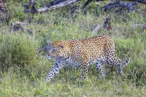
Leopard
The leopard is a strong, spotted big cat and the best climber of them all. It can carry its food high up into a tree, away from lions and hyenas. Leopards live in more kinds of places than any other big cat, from deserts to rainforests, across Africa and Asia.
Explore next
-
Watch
Landmark
Persepolis
Persepolis was a royal city of the Persian kings. King Darius I began it around 518 BCE on a huge terrace at the foot of a mountain in southwestern Iran. Its palaces had very tall, slender columns and walls carved with long parades of people bringing gifts. It is a UNESCO World Heritage Site.
-
Watch
City
Tehran
Tehran, the capital of Iran, spreads up the slopes of the Alborz Mountains, with snowy peaks to the north and desert to the south. Once a small village, and later a market town known for its pomegranates, it became the capital in 1786. Today it is a huge, modern city with an old roofed bazaar, a palace that is a World Heritage Site and the 435-meter Milad Tower.
-
Watch
3D
Animal
Cheetah
The cheetah is the fastest land animal. It can go from standing still to 72 kilometers per hour in about two and a half seconds, and its top speed is around 100 kilometers per hour, as fast as a car on a highway. Cheetahs live mostly in Africa, with a very small group in Iran.
-
Watch
3D
Animal
Leopard
The leopard is a strong, spotted big cat and the best climber of them all. It can carry its food high up into a tree, away from lions and hyenas. Leopards live in more kinds of places than any other big cat, from deserts to rainforests, across Africa and Asia.
-
Watch
Natural wonder
Mount Ararat
Mount Ararat is a huge volcanic mountain in the far east of Türkiye, close to where Türkiye, Iran and Armenia meet. It has two peaks: Great Ararat, about 5,165 meters high and the tallest mountain in Türkiye, and the smaller, cone-shaped Little Ararat. Snow covers the top all year, and a glacier clings to its north side.
-
Watch
Landmark
Susa
Susa, in southwest Iran, is one of the most ancient places where towns first grew. People built there from more than 6,000 years ago until about 800 years ago, one town on top of another. It was the capital of the Elamites and later of the Persian king Darius I, whose great palace still lies in ruins there.
-
 Watch
 Country
Turkmenistan
Turkmenistan is a country in Central Asia, and nine-tenths of it is desert. The huge Karakum sand desert fills its middle, while people live mostly in green oases along rivers and mountains. Ancient Silk Road cities such as Merv stand here, and the 2022 national census counted about 7.1 million people.
-
 Watch
 Country
Afghanistan
Afghanistan is a landlocked country in south-central Asia. The high Hindu Kush mountains run across its middle, sandy deserts lie in the southwest, and the capital, Kabul, sits in a valley about 1,800 meters above sea level.
For parents & teachers
What children will learn
- Locate Iran and name its neighbors and the seas on its north and south.
- Describe how a high, dry plateau ringed by mountains shapes where people live and how they find water.
- Name some of Iran's historic places, from Persepolis to Isfahan, and roughly when they were built.
- Describe the many languages, foods and celebrations in Iran without treating them as one single culture.
Recommended ages: 3 to 17 · About 15 minutes
Talk about it
- Why do you think most people in Iran live around the edges of the plateau?
- How might a town in a desert get water if there is no river nearby?
- What old building or market near you do people still use today, like the bazaar in Tabriz?
Try at home or in class
- Fill a tray with damp sand, slope it, and poke a covered straw tunnel from the high end to the low end; pour water at the top to see how a qanat carries water by gravity.
- On a map, trace a ring around Iran's central plateau and mark where Tehran, Isfahan and Shiraz sit.
Key vocabulary: plateau, qanat, bazaar, yardang, dynasty, republic, World Heritage Site
Where these facts come from
- Wikidata , Wikimedia Foundation (CC0 1.0)
- Natural Earth vector data , Natural Earth (NACIS) (Public domain)
- UNESCO World Heritage List , UNESCO World Heritage Centre (Linked as a reference; site facts come from Wikidata)
- Iran (introduction) , Encyclopaedia Britannica
- Iran: Relief , Encyclopaedia Britannica
- Iran: Soils and climate , Encyclopaedia Britannica
- Iran: Plant and animal life , Encyclopaedia Britannica
- Iran: Languages , Encyclopaedia Britannica
- Iran: Religion , Encyclopaedia Britannica
- Iran: Settlement patterns , Encyclopaedia Britannica
- Iran: Daily life and social customs , Encyclopaedia Britannica
- Nowruz , Encyclopaedia Britannica
- Iran: Sports and recreation , Encyclopaedia Britannica
- Iran: Government and society , Encyclopaedia Britannica
- Iran: The Islamic republic , Encyclopaedia Britannica
- Tehran , Encyclopaedia Britannica
- Mount Damavand , Encyclopaedia Britannica
- Caspian Sea , Encyclopaedia Britannica
- Cheetah , Encyclopaedia Britannica
- Population, total: Iran, Islamic Rep. , World Bank
- Persepolis , UNESCO World Heritage Centre
- Pasargadae , UNESCO World Heritage Centre
- Meidan Emam, Esfahan , UNESCO World Heritage Centre
- Bam and its Cultural Landscape , UNESCO World Heritage Centre
- Tabriz Historic Bazaar Complex , UNESCO World Heritage Centre
- Historic City of Yazd , UNESCO World Heritage Centre
- The Persian Qanat , UNESCO World Heritage Centre
- Lut Desert , UNESCO World Heritage Centre
- Hyrcanian Forests , UNESCO World Heritage Centre
- PlayOwl region table, version 1 , PlayOwl (PlayOwl original data)
- flag-icons 7.5.0 , Panayiotis Lipiridis and contributors (MIT)
- Wikimedia Commons , Wikimedia Foundation (Per file (public domain, CC0, CC BY or CC BY-SA); see each media record)
Checked, not yet human-reviewed. Last updated October 28, 2026. Spotted a mistake? Tell us.
Picture credits
- Photo: Mshayati, CC BY-SA 4.0, via Wikimedia Commons · source · license
- Photo: Arad Mojtahedi, CC BY-SA 3.0, via Wikimedia Commons · source · license
- Photo: Amir Pashaei, CC BY-SA 4.0, via Wikimedia Commons · source · license
- Photo: Asif Masimov (masimovasif.net), CC BY-SA 4.0, via Wikimedia Commons · source · license
- Photo: Valen1988, CC BY-SA 4.0, via Wikimedia Commons · source · license
- Photo: Bernd81, CC BY-SA 4.0, via Wikimedia Commons · source · license
- Photo: Arad Mojtahedi, CC BY-SA 3.0, via Wikimedia Commons · source · license
- Photo: Pedram forouzanfar, CC BY-SA 4.0, via Wikimedia Commons · source · license