
 Country
Asia
Pakistan
Pakistan is a big country in South Asia. It has some of the tallest mountains on Earth, the long Indus River and very old cities.
Pakistan is a country in South Asia that stretches from icy mountain peaks in the north down the fertile valley of the Indus River to the Arabian Sea. It has busy cities such as Karachi and Lahore, its capital is Islamabad, and its 2023 census counted 241.49 million people.
Pakistan runs from the Pamirs and the Karakoram down the Indus plain to the Arabian Sea; about three-fifths of its land is mountain and plateau. Home of Mohenjo-daro, one of the cradles of civilization, it became independent in 1947, and the Pakistan Bureau of Statistics' 2023 digital census counted 241.49 million people.
Photo: Muhammad Ashar, CC BY-SA 4.0, via Wikimedia Commons
Discover Pakistan
Pakistan is a country in South Asia.
Very tall, snowy mountains stand in the north. A long river called the Indus flows to the sea. The south has a coast, and there are deserts too. The capital city is called Islamabad.
Pakistan is a country in South Asia. Its neighbors are Iran to the west, Afghanistan to the northwest and north, China to the northeast and India to the east and southeast. The Arabian Sea forms its southern edge.
About three-fifths of Pakistan is mountains and high plateaus, and the rest is wide, flat plain along the Indus River. The capital, Islamabad, is in the foothills in the north, and the largest city, Karachi, is on the coast in the south. Pakistan's 2023 census counted 241.49 million people.
Britannica describes Pakistan as a populous multiethnic country associated historically and culturally with Iran, Afghanistan and India. It is bounded by Iran to the west, Afghanistan to the northwest and north, China to the northeast, India to the east and southeast and the Arabian Sea to the south, and lies at the western end of the Indo-Gangetic Plain. About three-fifths of the land is rough mountain and plateau, and two-fifths level plain, in five major regions: the Himalayan and Karakoram ranges, the Hindu Kush and western mountains, the Balochistan plateau, the submontane Potwar Plateau and Salt Range, and the Indus plain.
The Pakistan Bureau of Statistics' first digital census, begun on March 1, 2023, counted 241.49 million people, up from 207.68 million in 2017, an average growth rate of 2.55 percent a year; 61.18 percent of people lived in rural areas. The World Bank estimated 255,219,554 for 2025.
Cities and famous places
Karachi is the biggest city in Pakistan.
It is by the sea. Lahore has a big old fort with palaces inside. Very long ago, people built a city of bricks called Mohenjo-daro. Its ruins are still there.
Karachi, on the Arabian Sea, is Pakistan's largest city. Lahore, in the Punjab, is another big city, and the capital, Islamabad, is next to Rawalpindi in the northern foothills. Other big cities include Faisalabad, Peshawar, Multan and Hyderabad.
Pakistan has several World Heritage Sites. Mohenjo-daro, by the Indus, was a huge city built entirely of unbaked brick about 4,500 years ago, with a lower town laid out to strict rules. In Lahore, the Fort's marble palaces and the Shalimar Gardens, with terraces, waterfalls and ponds, come from the Mughal era. Rohtas Fort, built after 1541, has walls more than 4 kilometers long.
Karachi, on the Arabian Sea coast, is the largest city; Islamabad, the capital, lies in the Himalayan foothills beside Rawalpindi, amid the Shiwalik hills. UNESCO inscribed the ruins of Mohenjo-daro in 1980: a huge city of unbaked brick from the 3rd millennium BCE whose acropolis on high embankments, ramparts and strictly planned lower town show an early system of town planning. Taxila (1980) traces a city from a Neolithic mound through Sirkap (2nd century BCE) and Sirsukh (1st century CE), influenced by Persia, Greece and Central Asia and, from the 5th century BCE to the 2nd century CE, a center of learning.
The Fort and Shalimar Gardens in Lahore (1981) date from the height of Mughal civilization under Shah Jahan, with marble palaces decorated with mosaics and gilt, and gardens on three terraces with lodges, waterfalls and ornamental ponds. Rohtas Fort (1997), built by Sher Shah Suri after his 1541 defeat of the Mughal emperor Humayun, was never taken by storm; its walls extend for more than 4 km, with bastions and monumental gateways.

Mountains, rivers and deserts
Pakistan's mountains are some of the tallest in the world.
The highest is called K2. Snow and ice melt and run down into rivers. The Indus River runs from the mountains to the sea. Thorny bushes grow in the dry deserts.
In the far north, the western Himalayas and the Karakoram Range rise to more than 6,000 meters, and four peaks there are over 8,000 meters. K2, in the Karakoram, is 8,611 meters tall, and Nanga Parbat is 8,126 meters. Melting snow and glaciers feed the rivers, including the Indus.
The Indus flows south through a huge, flat plain to the Arabian Sea. In the Punjab, five rivers join it; the name Punjab comes from the Persian for "five waters." The northern mountains stand in the way of rain-bearing monsoon winds from the south, which shapes where rain falls. The Karakoram Highway, finished in 1970, crosses the mountains to China.
The western Himalayas occupy the whole northern end of the country, splitting into the Pir Panjal, Zanskar and Ladakh ranges, with the separate Karakoram system farther north; elevations run from about 4,000 m to more than 6,000 m, and four peaks exceed 8,000 m, including Nanga Parbat (8,126 m) and K2 (8,611 m). The Hindu Kush branches southwest from the Pamir Knot, with Tirich Mir at 7,690 m. The northern barrier intercepts monsoon winds, and snowmelt and glacier meltwater feed the rivers; Britannica notes that Karakoram glaciers are among the few in the world to have grown since the late 20th century. The north and west are seismically active, as a geologically young mountain system.
The Indus plain covers about 518,000 km² and slopes no more than about 1 m per 5 km from the Himalayan piedmont to the Arabian Sea. In the upper plain the Jhelum, Chenab, Ravi, Beas and Sutlej form the doabs of Punjab ("five waters"); in the lower plain the Indus becomes a single river with no significant tributaries. Drought-resistant acacia scrub covers the deserts, while fir, deodar, blue pine and spruce grow in the wetter northern mountains.

Animals of Pakistan
Snow leopards live high in the mountains.
Wild goats called markhor live in the mountains too. A special dolphin swims in the Indus River. Sea turtles lay their eggs on the beaches.
The northern mountains are home to brown bears, Himalayan black bears, leopards, rare snow leopards, ibex and wild sheep and goats such as the markhor and the Marco Polo sheep. Chinkara gazelles are found widely, and jackals, foxes, lynx, caracals and jungle cats live across the country.
The Indus River has its own freshwater dolphin, the Indus river dolphin, which is endangered. Crocodiles, gharials and pythons live in the Indus delta, and Manchhar Lake in Sindh has many water birds, such as ducks, geese and spoonbills. Green and olive ridley sea turtles nest on the Makran coast. National parks and game reserves have been set up since the 1970s.
Britannica notes that habitat destruction and excessive hunting have reduced the range of animal life, though wildlife is still abundant in some areas. Large mammals of the northern mountains include brown bears, Asiatic black bears (Ursus thibetanus), leopards, rare snow leopards, Siberian ibex and wild sheep and goats such as markhors, Marco Polo sheep (Ovis ammon polii) and Chiltan wild goats. Nilgais, chinkaras (Gazella gazella bennetti) and muntjacs occur, and jackals, foxes, Eurasian lynxes, caracals, fishing cats and jungle cats range widely; the Asiatic cheetah is probably extinct in Pakistan.
The Indus river dolphin's habitat has been severely stressed by hunting, pollution, dams and barrages. Crocodiles, gavials, pythons and wild boars inhabit the Indus delta, Manchhar Lake holds mallards, teals, shovelers, spoonbills, geese and pochards, and at least two sea turtles, the green and olive ridley, nest on the Makran coast. National parks and game preserves date from the 1970s, and the Indus river dolphin, snow leopard and gavial have been declared endangered.

People, languages and food
Pakistan's census counted 241.49 million people.
People speak many languages, such as Punjabi, Pashto, Sindhi and Urdu. Wheat bread, such as chapati, is the main food. Many people drink hot tea, called chai.
The 2023 census counted 241.49 million people. Pakistan has many peoples: Punjabis are the largest group, more than a third of the population, followed by Pashtuns, Sindhis, Saraikis, Balochs and others. Urdu is the only official language and is taught in schools along with regional languages, and English is still used in government.
Pakistani food has much in common with Indian food. Curries, lentils and vegetables such as potatoes, eggplant and okra are common, flavored with a mix of spices called masala. Wheat bread is the national staple, chapati and naan are the most common kinds, and many people drink a lot of hot tea. Most people are Muslims and celebrate Eid al-Fitr and Eid al-Adha.
The 2023 census counted 241.49 million people. Britannica describes five major ethnic groups: Punjabis (more than a third), Pashtuns (nearly a fifth), Sindhis and Saraikis, and the muhajirs (Muslims who came after partition in 1947) and Balochs, plus many smaller groups such as the Brahuis. No single language is common to the whole population; mother tongues include Punjabi, Pashto, Sindhi, Saraiki, Urdu, Balochi and Brahui. Urdu, which originated in the Mughal period and is the mother tongue of only a small share, is the official national language taught in schools, while English remains the lingua franca of government, the intelligentsia and the military. The population is overwhelmingly Muslim.
Cuisine has affinities with India's: curries, vegetables, regional masalas, yogurt, chicken, mutton and lamb, lentils and wheat bread (chapati and naan) as the national staple, with chai and lassi. The shalwar-kamiz is the most common traditional dress. Holidays include Eid al-Fitr and Eid al-Adha, Independence Day (August 14) and Pakistan Day (March 23), marking the Lahore Resolution of 1940.

From the Indus cities to today
Long, long ago, people built cities by the Indus River.
The cities were carefully planned. Much later, rulers built forts and gardens. In 1947 Pakistan became its own country.
By about 4,600 years ago, a civilization of well-planned cities had grown up in the Indus valley, centered on Mohenjo-daro and Harappa. Later, Gandhara in the northwest joined a network of trade and ideas that stretched from the Mediterranean to the heart of Asia, and Taxila, shaped by Persia, Greece and Central Asia, was a center of learning.
Centuries later, the Mughal emperors built forts, palaces and gardens, such as those in Lahore. The region became part of British India. On August 14, 1947, Pakistan became an independent country. Pakistan's constitution was adopted in 1973.
Britannica dates the Early Harappan period from about 5000 to 2600 BCE; by 2600 BCE a complex urban civilization had emerged in the Indus valley, centered on Mohenjo-daro and Harappa. From about the 6th century BCE, Gandhara in the northwest was drawn into a Persian network of exchange stretching from the Mediterranean to the heart of Asia, and Alexander the Great entered it by 327 BCE; Taxila, influenced by Persia, Greece and Central Asia, was a center of learning from the 5th century BCE to the 2nd century CE. Sher Shah Suri built Rohtas after 1541, and Mughal civilization reached its height under Shah Jahan, when Lahore's Fort and Shalimar Gardens took shape.
Pakistan was created at the partition of British India and became independent on August 14, 1947; Britannica records that about 8 million Muslim refugees moved to West Pakistan as a similar number of Hindus and Sikhs moved to India. East Pakistan became the independent country of Bangladesh in 1971. Since 1947, Britannica notes, the Kashmir region along the western Himalayas has been disputed, with Pakistan, India and China each controlling sections, and K2 and Nanga Parbat lie in the Pakistani-administered part. The constitution adopted in April 1973 was suspended in 1977; a process to reinstate it began in 1985.

Pakistan on the map
Find Pakistan on the globe.
It is in South Asia. The sea is at the bottom. Big mountains are at the top. Four countries are its neighbors.
Pakistan is in South Asia. Iran is to the west, Afghanistan to the northwest and north, China to the northeast and India to the east and southeast. The Arabian Sea is to the south.
The Indus River runs from the mountains in the north all the way to the sea in the south. In the far north, a narrow strip of Afghanistan called the Wakhan Corridor is all that separates Pakistan from Tajikistan. Mountain passes such as the Khyber Pass link Pakistan with Afghanistan.
Pakistan is bounded by Iran to the west, Afghanistan to the northwest and north, China to the northeast and India to the east and southeast, with the Arabian Sea coast as its southern border. Britannica notes that since 1947 the Kashmir region has been disputed, with Pakistan, India and China each controlling sections; Pakistani-administered Kashmir comprises Azad Kashmir and Gilgit-Baltistan.
Beyond the Karakoram lies Xinjiang, China, linked since 1970 by the Karakoram Highway from Gilgit to Kashgar, and to the northwest only the Wakhan Corridor separates Pakistan from Tajikistan. Passes south of the Kabul River, from north to south the Khyber, Kurram, Tochi, Gomal and Bolan, cross the western mountains. The Sulaiman and Kīrthar ranges separate the Balochistan plateau from the Indus plain. The map follows Natural Earth's land borders and does not show disputed lines as settled.
- Neighbors
- Iran, Afghanistan, China, India
- Coast
- Arabian Sea, in the south
- Highest peak
- K2, 8,611 m, in the Karakoram
- Indus plain
- about 518,000 km²
Amazing facts
-
Punjab means five waters.
The name Punjab comes from the Persian words for "five waters," after the five rivers that join the Indus there.
Punjab (Persian panj āb, "five waters") refers to the Jhelum, Chenab, Ravi, Beas and Sutlej, whose interfluves (doabs) form the upper Indus plain.
-
Some glaciers in Pakistan have grown bigger.
Many glaciers in the Karakoram are among the few in the world that have grown since the late 1900s.
Britannica notes that many Karakoram glaciers are among the few in the world to have grown in size since the late 20th century.
-
Mohenjo-daro was built with bricks a very long time ago.
Mohenjo-daro was built entirely of unbaked brick about 4,500 years ago, with a planned layout of streets.
UNESCO describes Mohenjo-daro as a huge city built entirely of unbaked brick in the 3rd millennium BCE, with evidence of an early system of town planning.
-
The Indus River has its own dolphin.
The Indus river dolphin is a freshwater dolphin, and it is endangered.
The Indus river dolphin's habitat has been severely stressed by hunting, pollution, dams and barrages, and it has been declared endangered.
-
Rohtas Fort has very long walls.
Rohtas Fort's walls stretch for more than 4 kilometers, and the fort was never captured by storm.
UNESCO calls Rohtas Fort, built by Sher Shah Suri after 1541, an exceptional example of early Muslim military architecture in Central and South Asia; it was never taken by storm.
Words to know
- plain
- a large area of flat land
- glacier
- a huge, slow-moving mass of ice that builds up from snow over many years
- civilization
- a large, organized society with cities, government and its own ways of life
- census
- an official count of all the people in a country
- monsoon
- a seasonal wind that brings a rainy season
- fort
- a strong building or group of buildings with thick walls, built for defense
- World Heritage Site
- a place UNESCO lists as important to all people, to be protected
Discovery challenge
-
What is the capital city of Pakistan?
Which city is the capital of Pakistan?
Which city, in the Himalayan foothills beside Rawalpindi, is Pakistan's capital?
- Islamabad
- Karachi
- Kabul
Show the answer
Islamabad
Islamabad is the capital. It is in the north.
Islamabad is the capital. Karachi is the largest city, and Kabul is the capital of Afghanistan.
Islamabad lies in the northern foothills; Karachi, on the Arabian Sea, is the largest city; Kabul is in Afghanistan.
-
Which long river flows through Pakistan?
Which river flows from Pakistan's northern mountains all the way to the Arabian Sea?
Which river, joined in Punjab by five tributaries, drains Pakistan's great plain to the Arabian Sea?
- The Nile
- The Indus
- The Mekong
Show the answer
The Indus
The Indus River flows through Pakistan to the sea.
The Indus flows south through Pakistan to the Arabian Sea. The Nile is in Africa and the Mekong is in Southeast Asia.
The Indus receives the Jhelum, Chenab, Ravi, Beas and Sutlej in the upper plain and flows as a single river through the lower plain.
-
What was the old city of Mohenjo-daro built from?
What material was Mohenjo-daro built from, about 4,500 years ago?
UNESCO describes Mohenjo-daro as built entirely of what material?
- Glass
- Steel
- Bricks
Show the answer
Bricks
It was built from bricks made of mud.
Mohenjo-daro was built entirely of unbaked brick.
The city was built entirely of unbaked brick in the 3rd millennium BCE, with an acropolis, ramparts and a planned lower town.
-
Which animal swims in the Indus River?
Which endangered animal lives in the fresh water of the Indus River?
Which endangered mammal's Indus habitat has been stressed by hunting, pollution, dams and barrages?
- A river dolphin
- A polar bear
- A kangaroo
Show the answer
A river dolphin
A dolphin! It lives in the river, not the sea.
The Indus river dolphin is a freshwater dolphin, and it is endangered.
The Indus river dolphin has been declared endangered, along with the snow leopard and the gavial.
-
Which breads do many people in Pakistan eat?
Which wheat breads are the most common in Pakistan?
Pakistan's national staple is wheat bread. Which two breads does Britannica name as the most common?
- Croissants
- Chapati and naan
- Bagels
Show the answer
Chapati and naan
Chapati and naan are flat breads made from wheat.
Chapati, an unleavened flat bread, and naan, slightly leavened, are the most common breads.
Wheat bread is the national staple; chapati (unleavened) and naan (slightly leavened) are the most common.
Places to discover in Pakistan
-
Watch
Landmark
Mohenjo-daro
Mohenjo-daro was the largest city of the Indus civilization, which UNESCO calls one of the world's three great ancient civilizations. Built of baked brick and flourishing by about 2500 BCE beside the Indus River, it had streets in a neat grid, houses with bathrooms and covered drains. Its ruins were found in 1922.
-
 Watch
Natural wonder
Himalayas
The Himalayas are a giant wall of mountains in Asia, between the high Plateau of Tibet and the plains of India. They hold the highest mountains in the world, including Mount Everest. They rose when the land carrying India crashed into Asia, and their snow and ice feed great rivers such as the Ganges and the Indus.
-
Watch
Natural wonder
K2
K2 is the world's second highest mountain, 8,611 meters tall, in the Karakoram Range of Asia. It got its short name in 1856, when a surveyor marked it as the second peak he measured in the Karakoram. It is one of the hardest mountains to climb, and its summit was first reached in 1954.
Animals of Pakistan
-
 Watch
Animal
Snow leopard
The snow leopard lives high in the mountains of Central Asia, where it is freezing cold and the ground is steep and rocky. Thick fur, huge furry paws and a tail almost as long as its body help it survive. It is so hard to spot that people call it the ghost cat of the mountains.
-
 Watch
Animal
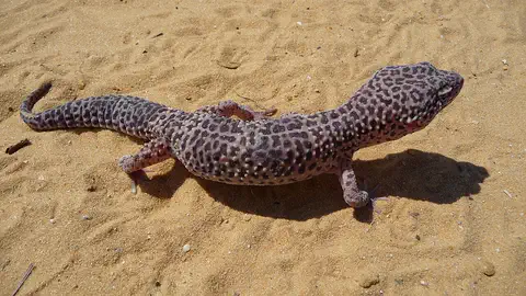
Leopard gecko
The leopard gecko is a spotted lizard from the rocky deserts and dry grasslands of Pakistan, Afghanistan, northwestern India and Nepal. It hunts insects and scorpions at night, stores fat in its thick tail, and has real eyelids. It is also one of the most popular pet lizards in the world.
-
 Watch
Animal
Indian cobra
The Indian cobra, or spectacled cobra, lives across South Asia, from Pakistan to Sri Lanka. It raises its head and spreads a hood marked with a pattern like a pair of glasses, it eats lots of rats and mice, and it is venomous, so it is an animal to admire from far away.
Explore next
-
Watch
Landmark
Mohenjo-daro
Mohenjo-daro was the largest city of the Indus civilization, which UNESCO calls one of the world's three great ancient civilizations. Built of baked brick and flourishing by about 2500 BCE beside the Indus River, it had streets in a neat grid, houses with bathrooms and covered drains. Its ruins were found in 1922.
-
Watch
Natural wonder
K2
K2 is the world's second highest mountain, 8,611 meters tall, in the Karakoram Range of Asia. It got its short name in 1856, when a surveyor marked it as the second peak he measured in the Karakoram. It is one of the hardest mountains to climb, and its summit was first reached in 1954.
-
Watch
Animal
Snow leopard
The snow leopard lives high in the mountains of Central Asia, where it is freezing cold and the ground is steep and rocky. Thick fur, huge furry paws and a tail almost as long as its body help it survive. It is so hard to spot that people call it the ghost cat of the mountains.
-
Watch
Animal
Leopard gecko
The leopard gecko is a spotted lizard from the rocky deserts and dry grasslands of Pakistan, Afghanistan, northwestern India and Nepal. It hunts insects and scorpions at night, stores fat in its thick tail, and has real eyelids. It is also one of the most popular pet lizards in the world.
-
Watch
Natural wonder
Himalayas
The Himalayas are a giant wall of mountains in Asia, between the high Plateau of Tibet and the plains of India. They hold the highest mountains in the world, including Mount Everest. They rose when the land carrying India crashed into Asia, and their snow and ice feed great rivers such as the Ganges and the Indus.
-
Watch
Animal
Indian cobra
The Indian cobra, or spectacled cobra, lives across South Asia, from Pakistan to Sri Lanka. It raises its head and spreads a hood marked with a pattern like a pair of glasses, it eats lots of rats and mice, and it is venomous, so it is an animal to admire from far away.
-
 Watch
 Country
Afghanistan
Afghanistan is a landlocked country in south-central Asia. The high Hindu Kush mountains run across its middle, sandy deserts lie in the southwest, and the capital, Kabul, sits in a valley about 1,800 meters above sea level.
-
 Watch
 Country
Azerbaijan
Azerbaijan is a country on the southern side of the Caucasus Mountains, along the western shore of the Caspian Sea. It has high mountains, wide lowlands and forests, its capital is Baku, and about 10.3 million people lived there in mid-2026.
For parents & teachers
What children will learn
- Locate Pakistan, name its neighbors and trace the Indus from the mountains to the Arabian Sea.
- Describe Pakistan's mountains, glaciers and great river plain, and how mountains affect its rainfall.
- Describe some of Pakistan's peoples, languages, foods and wildlife without treating them as one single culture.
- Outline Pakistan's history from the Indus civilization to independence in 1947.
Recommended ages: 3 to 17 · About 15 minutes
Talk about it
- Why do you think the first great cities in this region grew up beside the Indus River?
- How can mountains far to the north change how much rain falls in the south?
- Pakistan has many languages. What helps people who speak different languages understand each other?
Try at home or in class
- On a map, follow the five rivers of the Punjab until they join the Indus, then follow the Indus to the Arabian Sea.
- Build a small town plan from building blocks with straight streets in a grid, like the planned lower town of Mohenjo-daro.
Key vocabulary: plain, glacier, civilization, census, monsoon, fort, World Heritage Site
Where these facts come from
- Wikidata , Wikimedia Foundation (CC0 1.0)
- Natural Earth vector data , Natural Earth (NACIS) (Public domain)
- UNESCO World Heritage List , UNESCO World Heritage Centre (Linked as a reference; site facts come from Wikidata)
- Pakistan (introduction and Land) , Encyclopaedia Britannica
- Pakistan: The Himalayan and Karakoram ranges , Encyclopaedia Britannica
- Pakistan: The Indus River plain , Encyclopaedia Britannica
- Pakistan: Plant and animal life , Encyclopaedia Britannica
- Pakistan: People (ethnic groups, languages) , Encyclopaedia Britannica
- Pakistan: Daily life and social customs , Encyclopaedia Britannica
- Pakistan: History , Encyclopaedia Britannica
- Pakistan: Constitutional framework , Encyclopaedia Britannica
- Announcement of results of 7th Population and Housing Census-2023 , Pakistan Bureau of Statistics
- Population, total: Pakistan , World Bank
- Archaeological Ruins at Moenjodaro , UNESCO World Heritage Centre
- Fort and Shalamar Gardens in Lahore , UNESCO World Heritage Centre
- Rohtas Fort , UNESCO World Heritage Centre
- Taxila , UNESCO World Heritage Centre
- PlayOwl region table, version 1 , PlayOwl (PlayOwl original data)
- flag-icons 7.5.0 , Panayiotis Lipiridis and contributors (MIT)
- Wikimedia Commons , Wikimedia Foundation (Per file (public domain, CC0, CC BY or CC BY-SA); see each media record)
Checked, not yet human-reviewed. Last updated October 24, 2026. Spotted a mistake? Tell us.
Picture credits
- Photo: Muhammad Ashar, CC BY-SA 4.0, via Wikimedia Commons · source · license
- Photo: Rohaan Bhatti, CC BY-SA 3.0, via Wikimedia Commons · source · license
- Photo: Zacharie Grossen, CC BY-SA 4.0, via Wikimedia Commons · source · license
- Photo: Proudpakistani11, CC BY-SA 4.0, via Wikimedia Commons · source · license
- Photo: Bilalhassan88, CC BY-SA 3.0, via Wikimedia Commons · source · license
- Photo: Saqib Qayyum, CC BY-SA 3.0, via Wikimedia Commons · source · license
- Photo: Hussain Khalid, CC BY-SA 4.0, via Wikimedia Commons · source · license
- Photo: Farhan from Karachi, Pakistan, CC BY 2.0, via Wikimedia Commons · source · license