
City Africa
São Tomé
São Tomé is the capital of São Tomé and Príncipe. It is a city on an island near the equator.
São Tomé is the capital of São Tomé and Príncipe, a small country of volcanic islands in the Atlantic Ocean, just north of the equator. The city curves around Ana Chaves Bay. In the 2024 census, 80,647 people were counted in its district, Água Grande.
São Tomé, capital of the archipelago state of São Tomé and Príncipe, lies on Ana Chaves Bay on the island of São Tomé, about 220 km northwest of Gabon. Its district, Água Grande, counted 80,647 people in the census of 15 November 2024; the city itself had 66,888 in 2012.
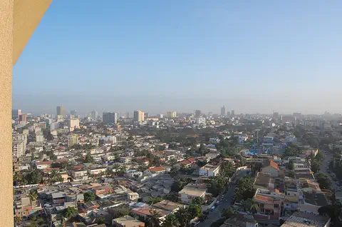
Photo: wsrolim, CC BY-SA 4.0, via Wikimedia Commons
Discover São Tomé
São Tomé is the capital city of a small island country. The country is called São Tomé and Príncipe.
The city is by the sea, very close to the equator.
São Tomé is the capital of São Tomé and Príncipe, which Universalis calls Africa's smallest state. The country is made of two main islands in the Atlantic, about 220 kilometers northwest of Gabon, just north of the equator. The capital is on the bigger island, also called São Tomé.
In the census of November 2024, 80,647 people were counted in Água Grande, the district whose capital is São Tomé. In the 2012 census the city itself had 66,888 people, far more than any other town in the country.
Universalis: the Democratic Republic of São Tomé and Príncipe is the smallest African state, an archipelago of two islands (São Tomé, 859 km2, capital São Tomé; Príncipe, 142 km2, capital Santo António) and a few islets about 220 km northwest of Gabon; in 2010 the capital held more than a third of the country's 175,800 people.
Instituto Nacional de Estatística (via City Population): Água Grande district (16.5 km2; capital São Tomé) 32,375 (1981), 42,331 (1991), 51,886 (2001), 69,772 (2012) and 80,647 (15 November 2024); the urban area of São Tomé 51,246 (2001) and 66,888 (2012), rank 1, ahead of Neves (8,391) and Santana (7,445).
- Country
- São Tomé and Príncipe (the capital)
- People in Água Grande district, the capital's district (census 2024)
- 80,647
- People in the city of São Tomé (census 2012)
- 66,888
- Where
- on Ana Chaves Bay, island of São Tomé, just north of the equator
Roofs, trees and a curving bay
Look at the big blue bay! Boats float on the water. Red roofs and green trees fill the town.
This photo shows São Tomé from the air on 19 February 2020. The photographer labeled it Ana Chaves Bay. The bay curves around in a wide arc, with small boats and a few ships on the calm water and long piers reaching out from the shore.
In front, wide roads meet at roundabouts between red-roofed houses, white buildings and many green trees. Far away, low hills rise on the left, and two small islands sit on the horizon at the right.
Commons: own work by wsrolim, 19 February 2020, CC BY-SA 4.0, with the photographer's Portuguese caption 'Baía de Ana Chaves' and camera coordinates; the file name is a camera-style serial name.
In the picture: the arc of Ana Chaves Bay with small boats, a few larger vessels and piers; the town's red and orange roofs, white buildings and dense tropical trees; several roundabouts joined by broad avenues; a hazy line of hills at upper left and two islets at upper right. Universalis: the islands are of volcanic origin, mountainous, with narrow coastal plains.
- Photo
- Ana Chaves Bay and São Tomé from the air, 19 February 2020
- Ana Chaves Bay
- a bay about 1.5 km north-northeast of the city's Wikidata point
- Islands
- volcanic and mountainous, with narrow coastal plains (Universalis)
A Portuguese town that became a capital
Long ago, people from Portugal ruled these islands. In 1975 the country became independent.
Universalis describes São Tomé and Príncipe as former Portuguese colonies that became independent in 1975. Part of the islands' land, once covered in forest, was used for big plantation farms, called roças.
At independence, Universalis says, nearly all of the two thousand Portuguese settlers left. Today Portuguese is the official language, and many people speak forro, a creole language based on Portuguese.
Universalis: two small African islands in the Gulf of Guinea, former Portuguese colonies, independent since 1975; land originally covered in forest was partly used for plantation agriculture (roças), and deforestation and overuse have worn out and eroded soils. Society is described in groups whose boundaries are blurred: Filhos da terra (long-free, mixed-descent families), Angolares (descendants of Angolan workers), Serviçais (former contract workers from Africa) and Tongas (African immigrants); the two thousand Portuguese settlers almost all left at independence. Official language Portuguese; the spoken language is forro, a Portuguese creole.
- Past
- the islands are former Portuguese colonies (Universalis)
- 1975
- independence
- Plantations
- part of the once-forested land was used for plantation farms, called roças
A bay for boats and an airport nearby
Boats sail in the bay. Planes fly in to an airport close to the city.
São Tomé sits on Ana Chaves Bay, and Wikidata places São Tomé International Airport about 4.9 kilometers north-northwest of the city's center point.
The country's second island, Príncipe, is much smaller, at 142 square kilometers, and its capital is Santo António. The mainland of Africa is about 220 kilometers away: Gabon lies to the southeast.
Universalis: São Tomé island 859 km2 (capital São Tomé); Príncipe 142 km2 (capital Santo António, about 5,000 inhabitants); a few isolated islets; the group lies 220 km northwest of Gabon. Wikidata (from the city point Q3932): Ana Chaves Bay (Q4750333) 1.50 km NNE; São Tomé International Airport (Q1418267, 39 ft elevation) 4.85 km NNW; Pico de São Tomé (Q1471391, 2,024 m) 23.07 km WSW.
- São Tomé International Airport
- about 4.9 km north-northwest of the city's Wikidata point
- Príncipe
- the second island, 142 km2, capital Santo António
- Distance to Africa
- about 220 km northwest of Gabon
Hot, wet and very green
São Tomé is warm and wet. It has a short dry time from June to September.
Because the islands lie just north of the equator, Universalis says, they have a humid tropical climate, with a short dry season from June to September. It gets cooler higher up the mountains.
The southern mountains get the most rain: their peaks, often wrapped in clouds, receive 4,000 millimeters or more a year. The highest is Pico de São Tomé, 2,024 meters high.
Universalis: just north of the equator, the archipelago has a humid tropical climate with a short dry season from June to September; temperature falls with altitude; rainfall is abundant on the southern heights, whose often cloud-capped summits receive 4,000 mm or more a year; the islands rise to 2,024 m at Pico de São Tomé.
- Climate
- humid tropical, with a short dry season from June to September (Universalis)
- Rain on the southern heights
- 4,000 mm or more a year (Universalis)
- Highest point
- Pico de São Tomé, 2,024 m
Forest, plantations and a shared language
People in São Tomé speak Portuguese and a language called forro. Rainforest with special birds covers the mountains.
In São Tomé people speak Portuguese, the official language, and forro, a creole language that grew out of Portuguese, Universalis says.
On the mountain slopes, the rainforest that was never cut down is home to plants and animals found nowhere else, especially birds. Elsewhere, part of the land was turned into plantations, and Universalis says cutting the forest and overusing the land have worn out and washed away the soil in places.
Universalis: on the slopes, the tropical forest that has not been exploited shelters a unique flora and fauna (birds); elsewhere the originally forested land was partly used for plantation agriculture (roças), and deforestation and overexploitation have favored soil exhaustion and erosion. Population 240,254 (2025) for the country; official language Portuguese; spoken language forro, a Portuguese creole.
City Population (census 2024): the country had 209,607 people, of whom 140,801 were counted as urban.
- Languages
- Portuguese (official); forro, a Portuguese creole, is spoken
- Forest
- untouched rainforest on the slopes has unique plants and birds (Universalis)
- Country (estimate 2025, Universalis)
- 240,254 people
São Tomé on the map
Find Africa on the globe. Look at the sea on its west side, near the equator. São Tomé is on a small island there.
São Tomé lies at about 0.3° north and 6.7° east, only a short way north of the equator, in the Atlantic Ocean.
Measured from the city's center point on Wikidata, Ana Chaves Bay is about 1.5 kilometers north-northeast, the international airport about 4.9 kilometers north-northwest and Pico de São Tomé about 23 kilometers west-southwest.
São Tomé lies at about 0.33° N and 6.73° E (Natural Earth point, 0.72 km SE of the Wikidata point). From the Wikidata point (Q3932; 6.7283° E, 0.3375° N): Ana Chaves Bay 1.50 km NNE; São Tomé International Airport 4.85 km NNW; Pico de São Tomé 23.07 km WSW.
- Latitude
- about 0.3° north
- Longitude
- about 6.7° east
- Neighbor
- about 220 km northwest of Gabon
Amazing facts
-
São Tomé is very close to the equator, the line around the middle of the Earth.
São Tomé and Príncipe lies just north of the equator, Universalis says; the capital is at about 0.3° north.
Universalis: the archipelago lies just north of the equator; Natural Earth places São Tomé at about 0.33° N.
-
São Tomé and Príncipe is the smallest country in Africa.
Universalis calls São Tomé and Príncipe the smallest state in Africa.
Universalis: 'le plus petit État africain', made of São Tomé (859 km2) and Príncipe (142 km2) and a few islets.
-
The mountain tops on São Tomé often wear a hat of clouds.
The summits of the southern mountains are often capped with clouds and get 4,000 millimeters of rain or more a year, Universalis says.
Universalis: rainfall is abundant on the southern heights, whose often cloud-capped summits receive 4,000 mm or more annually.
-
Special birds live in the rainforest on São Tomé's mountains.
Universalis says the untouched rainforest on the slopes is home to unique plants and animals, especially birds.
Universalis: on the slopes, the tropical forest that has not been exploited shelters a unique flora and fauna (birds).
Words to know
- equator
- the imaginary line around the middle of the Earth, halfway between the North and South Poles
- archipelago
- a group of islands
- bay
- a part of the sea that curves into the land
- creole
- a language that grew from a mix of languages and became people's everyday language
- plantation
- a large farm where one crop is grown, often for selling abroad
- district
- an area of a country with its own local government
Discovery challenge
-
São Tomé is the capital of which country?
São Tomé is the capital of which island country?
São Tomé is the capital of which state, described by Universalis as Africa's smallest?
- São Tomé and Príncipe
- Iceland
- Sri Lanka
Show the answer
São Tomé and Príncipe
São Tomé and Príncipe!
São Tomé and Príncipe.
São Tomé and Príncipe.
-
Which line is São Tomé very close to?
São Tomé lies just north of which line around the Earth?
At about 0.3° N, São Tomé is just north of which line of latitude?
- The equator
- The Arctic Circle
- The Tropic of Capricorn
Show the answer
The equator
The equator!
The equator.
The equator (0°).
-
What is the name of the bay by the city?
Which bay does the photographer name in the photo of São Tomé?
The photographer's caption 'Baía de Ana Chaves' names which bay?
- Ana Chaves Bay
- Hudson Bay
- Bay of Biscay
Show the answer
Ana Chaves Bay
Ana Chaves Bay!
Ana Chaves Bay.
Ana Chaves Bay.
-
When is the dry time in São Tomé?
Universalis says the short dry season lasts from June to which month?
The humid tropical climate has a short dry season from June to which month?
- September
- December
- March
Show the answer
September
From June to September!
September.
September.
-
Which language is spoken in São Tomé, besides Portuguese?
Besides Portuguese, which creole language does Universalis say is spoken?
Which Portuguese creole does Universalis name as the spoken language?
- Forro
- Swahili
- Maori
Show the answer
Forro
Forro!
Forro.
Forro.
Nearby places
-
 Watch
City
Douala
Douala is the main port of Cameroon, on the estuary of the Wouri River near the Gulf of Guinea. The encyclopedia Larousse calls it the country's economic capital, a center of trade and industry. Cameroon's 2005 census counted 1,906,962 people in the city.
-
 Watch
City
Yaoundé
Yaoundé is the capital of Cameroon, in Central Africa. Cameroon's official projection gives the city 3,762,900 people at the start of 2025, the second-most in the country after Douala. It grew from a German military post of the late 19th century, among hills 700 to 1,100 meters high.
-
 Watch
City
Cotonou
Cotonou is the largest city in Benin, on a strip of land between the Atlantic Ocean and Lake Nokoué, Universalis says. It is not the official capital, which is Porto-Novo, but it grew with its port. Benin's 2013 census counted 679,012 people in Cotonou.
-
 Watch
City
Lomé
Lomé is the capital of Togo, on the Atlantic coast of West Africa, right at the border with Ghana. Togo's 2022 census counted 2,188,376 people in Lomé, more than ten times Kara, the next city. A monument in the city marks Togo's independence on 27 April 1960.
-
 Watch
Natural wonder
River Congo
The Congo is Africa's second-longest river, about 4,700 kilometers long. It curves in a giant arc through the rainforests of central Africa and empties into the Atlantic Ocean. Rain falls in its basin all year, so it carries a huge amount of water, and its wild lower rapids are home to about 320 kinds of fish, about 90 of them found nowhere else.
-
 Watch
City
Accra
Accra is the capital of Ghana, on the coast of West Africa. It began as a small village of the Ga people beside the Korle Lagoon. Three old forts built by European traders still stand by the sea. More than 5.4 million people lived in the Greater Accra Region at the 2021 census.
-
 Watch
City
Abuja
Abuja is the capital of Nigeria, in the middle of the country. It was planned from the start: in 1976 the government decided to build a new capital on the savanna, and in 1991 it moved there from Lagos. Planners set aside land for parks and green spaces, and the huge Aso Rock rises at the city's edge.
-
 Watch
City
Brazzaville
Brazzaville, capital of the Republic of the Congo, lies on the Pool Malebo, a lake on the Congo River, facing Kinshasa across the water. It began as a small post in October 1880. The 2023 census counted 2,138,236 people in the commune of Brazzaville (preliminary figures).
Explore next
-
Watch
 Country
São Tomé and Príncipe
São Tomé and Príncipe is an island country in the Gulf of Guinea, right on the Equator off the west coast of Central Africa. Its two main islands are old volcanoes covered in rainforest, home to plants and animals found nowhere else. Portugal ruled the islands for about 500 years, until independence in 1975. The 2024 census counted 209,607 people.
-
 Watch
City
Luanda
Luanda is the capital of Angola, on the Atlantic coast of Africa. It began in 1575 as a Portuguese fort and trading post beside a bay, and it is now Angola's largest city: the 2024 census counted 8,642,051 people there.
-
Watch
City
Accra
Accra is the capital of Ghana, on the coast of West Africa. It began as a small village of the Ga people beside the Korle Lagoon. Three old forts built by European traders still stand by the sea. More than 5.4 million people lived in the Greater Accra Region at the 2021 census.
-
 Watch
City
Abidjan
Abidjan is the largest city of Côte d'Ivoire, with 5,616,633 people at the 2021 census. Spread around the Ébrié Lagoon, it grew from a colonial port: a canal finished in 1950 opened the lagoon to ships, and its Plateau district is a cluster of office towers, banks and government buildings.
-
Watch
City
Abuja
Abuja is the capital of Nigeria, in the middle of the country. It was planned from the start: in 1976 the government decided to build a new capital on the savanna, and in 1991 it moved there from Lagos. Planners set aside land for parks and green spaces, and the huge Aso Rock rises at the city's edge.
-
 Watch
City
Addis Ababa
Addis Ababa is the capital of Ethiopia, high in the hills of East Africa at about 2,355 meters. It was founded in the 1880s, and its name means 'new flower' in Amharic. Electric light-rail trains cross the city, and its National Museum shows a copy of Lucy, a famous fossil 3.2 million years old.
-
 Watch
City
Alexandria
Alexandria is Egypt's second-largest city, a port on the Mediterranean Sea west of the Nile delta. Alexander the Great founded it in 331 BC; a fort now stands on the ruins of its ancient lighthouse, and a new library on the site of its ancient one. About 5.36 million people lived there in 2023.
-
 Watch
City
Algiers
Algiers is the capital of Algeria, in North Africa, around a half-moon-shaped bay of the Mediterranean Sea. Its old town, the Kasbah, is a maze of narrow lanes and houses climbing a hill above the port, and it is a UNESCO World Heritage Site. The 2008 census counted about 2.4 million people in the city.
For parents & teachers
What children will learn
- Locate São Tomé just north of the equator, off the west coast of Africa.
- Explain what a creole language is.
- Describe how plantations changed the islands' forests.
- Explain why mountain slopes facing the rain can be much wetter than the coast.
Recommended ages: 3 to 17 · About 15 minutes
Talk about it
- What might be different about living in a capital on a small island?
- Why do mountain tops often have clouds around them?
- Why is untouched forest important for birds found nowhere else?
Try at home or in class
- Equator line: put a globe or map on the table and trace the equator, then find São Tomé just above it.
- Island map: draw two islands, mark the capital, a bay and a mountain, and add a scale.
- Census bars: draw bars for Água Grande in 1981, 2001 and 2024 and compare them.
Key vocabulary: equator, archipelago, bay, creole, plantation, district
Where these facts come from
- Wikidata , Wikimedia Foundation (CC0 1.0)
- Natural Earth vector data , Natural Earth (NACIS) (Public domain)
- São Tomé-et-Príncipe , Encyclopaedia Universalis
- São Tomé and Príncipe: Districts and Places , City Population (Thomas Brinkhoff), from the Instituto Nacional de Estatística
- File:Org 4cd8129a56d8fa1d 1582100284000.jpg (wsrolim, 19 February 2020) , Wikimedia Commons
- Wikimedia Commons , Wikimedia Foundation (Per file (public domain, CC0, CC BY or CC BY-SA); see each media record)
Checked, not yet human-reviewed. Last updated November 1, 2026. Spotted a mistake? Tell us.