
 Country
Africa
São Tomé and Príncipe
São Tomé and Príncipe is a small country made of islands. It sits on the Equator, off the coast of Africa. Green rainforest covers its mountains.
São Tomé and Príncipe is an island country in the Gulf of Guinea, right on the Equator off the west coast of Central Africa. Its two main islands are old volcanoes covered in rainforest, home to plants and animals found nowhere else. Portugal ruled the islands for about 500 years, until independence in 1975. The 2024 census counted 209,607 people.
São Tomé and Príncipe, two volcanic islands and several rocky islets in the Gulf of Guinea, was uninhabited when Portuguese navigators arrived about 1470. Its history runs from sugar plantations worked by enslaved Africans to a cacao economy that in some years of the early 20th century led the world, then independence on July 12, 1975, and a multiparty democracy since 1990. The 2024 census counted 209,607 residents.
Photo: wsrolim, CC BY-SA 4.0, via Wikimedia Commons
Discover São Tomé and Príncipe
São Tomé and Príncipe has two main islands.
The big one is São Tomé. The small one is Príncipe. People speak Portuguese there.
São Tomé and Príncipe is an island country in the Gulf of Guinea, a part of the Atlantic Ocean off the west coast of Central Africa. It sits right on the Equator. Its closest neighbors are Gabon and Equatorial Guinea on the mainland.
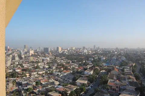
The country has two main islands and several small rocky islets. São Tomé is the larger, oval-shaped island; Príncipe lies about 145 kilometers to its northeast. Portuguese is the official language, and the 2024 census counted 209,607 people. The photo shows São Tomé city beside Ana Chaves Bay.
Britannica describes an island country of Central Africa on the Equator in the Gulf of Guinea: the oval island of São Tomé, the smaller Príncipe about 145 km to its northeast, and rocky islets including Rôlas south of São Tomé and Caroço, Pedras and Tinhosas south of Príncipe. The total area is 1,001 km².
The National Institute of Statistics' fifth general census (November to December 2024) counted 209,607 residents, up from 178,739 in 2012; 95.3% live on São Tomé island and 4.7% on Príncipe. Standard Portuguese is official and understood by virtually everyone, and the currency is the dobra, pegged to the euro since 2010. The photo shows São Tomé city on Ana Chaves Bay.
São Tomé city and Santo António
São Tomé city is the capital.
It is by a bay on the big island. Santo António is the main town on Príncipe.
The capital, São Tomé city, stands on a bay in the northeast of São Tomé island, where the land is flatter and drier. About a third of the people live in the city and around it.
On Príncipe, the main town is Santo António. It was once the capital: in 1753 the Portuguese moved the capital there, and it moved back to São Tomé city in 1852. Many homes on the islands are built of wooden planks and raised up off the ground, alongside concrete buildings in the old Portuguese style.
People cluster in the drier, flatter northeast of both islands. Britannica notes that a third of the population lives in São Tomé city and its outskirts; in the 2024 census Água Grande, the capital's district, held 80,647 people (38.5%), while Príncipe, an autonomous region, had 9,830. Almost three-quarters of the population is urban, and many people live in dispersed settlements called lucháns.
Because of political unrest on São Tomé, the capital moved in 1753 to Santo António on Príncipe, whose harbor was busy; it returned to São Tomé city in 1852, when coffee and cacao shifted the economy back. Typical houses are of wooden planks raised above the ground, beside colonial-style concrete buildings and barrack-like housing on some plantations.
Volcanic peaks and heavy rain
The islands were made by volcanoes long ago.
Tall mountains drop down to the sea. It rains a lot on one side. It is warm all year.
High volcanic mountains rise in the south and west of both islands and drop steeply to the sea, but no volcano has erupted there for centuries. São Tomé Peak, the highest point, is 2,024 meters tall. Fast, rocky streams rush down to the coast in every direction.
Wet winds from the southwest hit the mountains, so the southwest of São Tomé gets more than 7,000 millimeters of rain a year, while the far northeast gets less than 760. The coast is warm and humid all year. High in the mountains the nights are cold and misty rain falls almost all the time, but there is never frost or snow.
In the south and west of both islands volcanic mountains fall precipitously to the sea, though neither island has seen volcanic activity in recent centuries; they descend gradually to small plains in the northeast. São Tomé Peak reaches 2,024 m and Príncipe Peak 948 m. Stream erosion has deeply dissected the uplands, and isolated volcanic plugs, such as João Dias Pai and João Dias Filho on Príncipe's west coast, stand out as landmarks.
The climate is maritime and tropical, with many microclimates. Moist southwesterlies give the southwest of São Tomé more than 7,000 mm of rain a year against under 760 mm in the far northeast, where the dry season, the gravana, lasts from June to September. Coastal temperatures average in the upper 20s °C with humidity near 80%; nights fall below 10 °C at about 700 m, and above 1,000 m misty rain is almost continuous.
Found nowhere else
Rainforest grows on the mountains.
Many plants and animals here live nowhere else. Sea turtles lay eggs on the beaches.
The islands were once covered in thick rainforest. Some forest remains, mostly in the south and west. Because the islands are so isolated, many of their plants and animals are endemic: found nowhere else in the world. Birds include ibises, shrikes and grosbeaks.
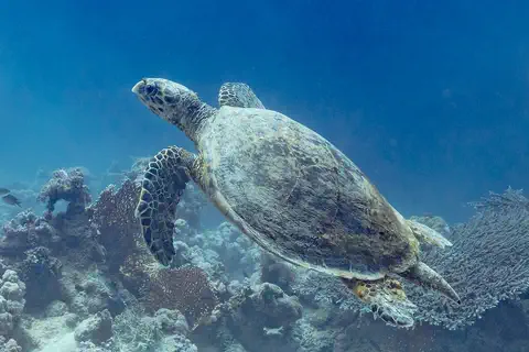
Scientists from the California Academy of Sciences say almost every expedition has found new species on the islands. Sea turtles lay their eggs on the beaches; São Tomé has important nesting areas for hawksbill turtles. The hawksbill in the photo was photographed in Egypt.
The original cover was luxuriant tropical rainforest grading from lowland to mist forest; what survives, mainly in the south and west, is largely secondary growth on abandoned plantations. Long isolation and varied environments produced many rare and endemic species, and Britannica warns that many plants, birds, reptiles and small mammals are threatened by pressure on the remaining forest.
UNESCO, which made Príncipe a biosphere reserve in 2012, notes high endemism in vascular plants, molluscs, insects, birds, reptiles and bats, and the island's importance for breeding sea turtles, seabirds and cetaceans. São Tomé has important nesting and foraging areas for the critically endangered eastern Atlantic hawksbill subpopulation; in 2015 Programa Tatô surveyed 140 km of coast with local fishers to find more. The hawksbill photo was taken in Ras Muhammad National Park, Egypt.
Creole languages, Tchiloli and football
Most people speak Portuguese.
Many also speak a local language. Football is the favorite sport. Cacao trees grow on the farms.
Most São Toméans are Forros, whose ancestors were Europeans and enslaved Africans; forro means 'free man' in Portuguese. The Angolares are descended from Angolans shipwrecked on São Tomé about 1540. Besides Portuguese, three local creole languages are spoken, and the culture blends Portuguese and African ways.
Tchiloli, a play based on a Portuguese drama from the 1500s, is performed on São Tomé. Football (soccer) is the most popular sport. Cacao trees, whose seeds become chocolate, cover a little less than two-thirds of the farmland, and cocoa is the main export.
The population is mainly Forros (from forro, 'free man'), descendants of immigrant Europeans and enslaved Africans, plus the Angolares, descended from formerly enslaved Angolans shipwrecked about 1540, who lived apart in the south until the late 19th century. Cabo Verdeans are the largest group of resident foreigners. Three Portuguese-based creoles are spoken: Sãotomense, Angolar and Principense, the last by only a few hundred people. The Roman Catholic Church is the largest faith.
The creole culture blends Portuguese and African elements: Tchiloli on São Tomé and Auto da Floripes on Príncipe are both based on 16th-century Portuguese dramas. Football has been the most popular sport since a first association in 1931. About two-fifths of the land is cultivated, cacao covering a little less than two-thirds of it, and cocoa earns almost all merchandise export income.
From empty islands to independence
Long ago, nobody lived on these islands.
Portuguese sailors came about 550 years ago. In 1975 the islands became their own country.
No one lived on the islands when Portuguese sailors arrived about 1470. The Portuguese sent settlers and brought enslaved Africans to grow sugarcane, and for a short time in the 1500s São Tomé produced more sugar than anywhere else.
Later, coffee and then cacao became the main crops; in some years of the early 1900s the islands grew more cocoa than any other country. Slavery was abolished in 1875, but plantation workers were often treated harshly. The islands became independent on July 12, 1975, and have held free, multiparty elections since the early 1990s.
Portuguese navigators found the islands uninhabited about 1470 and brought settlers, including convicts, and enslaved Africans to grow sugar. São Tomé was briefly the world's largest sugar producer in the 16th century, until Brazilian competition and poor-quality sugar ruined the industry; Amador, who led enslaved people in a rising that nearly overran the island in 1595, is regarded by many as a national hero. The colony then served as an entrepôt for the slave trade to Brazil.
Coffee and cacao arrived in the 19th century; cacao replaced coffee in the 1890s. Slavery was legally abolished in 1875, but contract labor on absentee-owned plantations remained harsh, and the 1953 Batepá Massacre became a rallying point for independence. After Portugal's 1974 coup, power passed to the MLSTP; independence came on July 12, 1975. Liberalization from 1985 led to multiparty democracy in 1990 and the first free elections in 1991.
São Tomé and Príncipe on the map
Find Africa on the globe.
Look at the bend in its west coast. Follow the Equator out to sea. Two little islands sit there.
Find the place where Africa's west coast bends, the Gulf of Guinea. Follow the Equator, the imaginary line around the middle of Earth, out into the gulf: São Tomé and Príncipe sits on it.
The country has no land borders. Its nearest neighbors are Gabon and Equatorial Guinea, on the coast of the mainland to the east.
The archipelago lies on the Equator in the Gulf of Guinea; Príncipe is about 145 km northeast of São Tomé, and Rôlas islet lies off São Tomé's southern tip. Gabon and Equatorial Guinea are the nearest countries.
In 2001 the country and Nigeria agreed to oversee together the exploration of possible deepwater oil in a zone where their sea boundaries overlap, an area that had drawn foreign investors in the late 1990s and early 2000s.
- Total area
- 1,001 km²
- Distance from São Tomé to Príncipe
- about 145 km
- São Tomé Peak
- 2,024 m
- People (2024 census)
- 209,607
Amazing facts
-
Nobody lived on these islands until about 550 years ago.
When Portuguese sailors arrived about 1470, no people lived on the islands at all.
São Tomé and Príncipe were uninhabited when Portuguese navigators discovered them about 1470.
-
One side of São Tomé gets more than nine times as much rain as the other.
The southwest of São Tomé gets more than 7,000 millimeters of rain a year, while the far northeast gets less than 760.
Mountains intercepting moist southwesterly winds give the southwest of São Tomé over 7,000 mm of rain a year, against under 760 mm in the far northeast.
-
Scientists keep finding new kinds of living things here.
Scientists from the California Academy of Sciences say almost every one of their expeditions has found new species on the islands.
California Academy of Sciences researchers report that virtually every expedition has turned up new, undescribed species on both islands, which remain incompletely known.
-
Once, Príncipe's town was the capital.
From 1753 to 1852 the capital was Santo António, the main town on the small island of Príncipe.
Political unrest on São Tomé led the Portuguese to move the capital to Santo António on Príncipe in 1753; São Tomé city became the capital again in 1852.
Words to know
- endemic
- found naturally in one place and nowhere else in the world
- archipelago
- a group of islands
- creole language
- a language that grew from a mix of languages and became people's own everyday language
- cacao
- a tropical tree whose seeds, cocoa beans, are used to make chocolate
- biosphere reserve
- a place named by UNESCO where people try to protect nature while living and working there
- volcanic plug
- a tower of hard rock left behind when the softer rock of an old volcano wears away
Discovery challenge
-
Which imaginary line goes through São Tomé and Príncipe?
São Tomé and Príncipe sits right on which imaginary line around the middle of Earth?
Which line of latitude does the archipelago of São Tomé and Príncipe straddle?
- The Arctic Circle
- The Equator
- The Tropic of Cancer
Show the answer
The Equator
The Equator goes through the country.
The Equator, in the Gulf of Guinea.
The Equator (0°), in the Gulf of Guinea off Central Africa.
-
Which crop grows on most farms here?
Which crop, whose seeds are made into chocolate, is the main export?
Which crop covers a little less than two-thirds of the cultivated land and earns almost all merchandise export income?
- Wheat
- Cacao
- Apples
Show the answer
Cacao
Cacao trees grow here. Their seeds make chocolate.
Cacao: its seeds are cocoa beans.
Cacao, which replaced coffee as the main cash crop in the 1890s.
-
Who lived on the islands before the Portuguese came?
Who was living on the islands when Portuguese sailors arrived about 1470?
What did Portuguese navigators find living on the islands about 1470?
- Nobody
- Farmers from Gabon
- Fishers from Brazil
Show the answer
Nobody
Nobody lived there.
No one: the islands were uninhabited.
The islands were uninhabited.
-
What does endemic mean?
Many plants and animals here are endemic. What does that mean?
UNESCO notes high endemism on Príncipe. What makes a species endemic?
- It lives in many countries
- It lives only in zoos
- It is found nowhere else
Show the answer
It is found nowhere else
Endemic means it lives only there.
It is found in that one place and nowhere else.
It occurs naturally in one place only, often after long isolation, as on these islands.
Places to discover in São Tomé and Príncipe
Animals of São Tomé and Príncipe
Explore next
-
Watch
City
São Tomé
São Tomé is the capital of São Tomé and Príncipe, a small country of volcanic islands in the Atlantic Ocean, just north of the equator. The city curves around Ana Chaves Bay. In the 2024 census, 80,647 people were counted in its district, Água Grande.
-
 Watch
 Country
Gabon
Gabon is a country on the Atlantic coast of Africa, right on the equator. About three-fourths of it is covered by dense rainforest, home to forest elephants, gorillas and mandrills. Most people live in towns and cities, and the 2026 census counted about 3.5 million people.
-
 Watch
 Country
Equatorial Guinea
Equatorial Guinea has two parts: Río Muni, a piece of the African mainland covered in rainforest, and five islands, the biggest of which is Bioko, an island of old volcanoes. It was a colony of Spain, so Spanish is an official language and the main language people share. The national statistics office estimated 1,668,768 people in 2024; the last census, in 2015, counted 1,225,377.
-
 Watch
 Country
Cabo Verde
Cabo Verde is a country made of ten islands in the Atlantic Ocean, about 620 kilometers off the coast of West Africa. Some islands are flat and sandy, others are steep and volcanic, and rain is rare. Its people are famous for their music, and the 2021 census counted about 491,000 people living there.
-
 Watch
 Country
Angola
Angola is a large country in southwestern Africa, on the Atlantic Ocean. A narrow coast rises steeply to high plateaus, rivers such as the Cuanza run to the sea, and the Namib Desert reaches its far southwest. Its national statistics institute projects about 38.8 million people for 2026.
-
Watch
3D
Animal
Hawksbill sea turtle
The hawksbill sea turtle lives in warm seas around the world, mostly near coral reefs. Its pointed, hawk-like beak reaches into cracks in the reef to find sponges, its favorite food. Its beautiful patterned shell once made it a target for hunters, and today it is critically endangered.
-
 Watch
 Country
Democratic Republic of the Congo
The Democratic Republic of the Congo, or DR Congo, is the second-largest country in Africa. The mighty Congo River curves through its rainforests, volcanoes rise in the east, and its capital, Kinshasa, is a center of music, fashion and popular culture.
-
 Watch
 Country
Ethiopia
Ethiopia is a country on the Horn of Africa with no coast. Much of it is high, rugged land cut by the Great Rift Valley, it is one of the world's oldest countries, and more than 110 million people live there.
For parents & teachers
What children will learn
- Locate São Tomé and Príncipe on the Equator in the Gulf of Guinea.
- Explain why the southwest of São Tomé is much wetter than the northeast.
- Describe why isolated islands have many endemic species.
- Outline the history from uninhabited islands to sugar and cacao plantations and independence in 1975.
Recommended ages: 3 to 17 · About 15 minutes
Talk about it
- Why might islands far out at sea have animals found nowhere else?
- How could a mountain make one side of an island much rainier than the other?
- Chocolate starts as cacao seeds. What other foods come from far away?
Try at home or in class
- Lay a sheet over a pile of books to make a 'mountain', blow a fine mist from a spray bottle toward one side and see which side gets wetter.
- Look at a chocolate wrapper together and find where the cocoa came from on a map.
Key vocabulary: endemic, archipelago, creole language, cacao, biosphere reserve, volcanic plug
Where these facts come from
- Wikidata , Wikimedia Foundation (CC0 1.0)
- Natural Earth vector data , Natural Earth (NACIS) (Public domain)
- Sao Tome and Principe (introduction, land, climate, plant and animal life, people) , Encyclopaedia Britannica
- Sao Tome and Principe: Economy , Encyclopaedia Britannica
- Sao Tome and Principe: Government and society (education, cultural life, sports) , Encyclopaedia Britannica
- Sao Tome and Principe: History , Encyclopaedia Britannica
- Sao Tome and Principe: After independence , Encyclopaedia Britannica
- Resultados do V Recenseamento Geral da População e Habitação 2024 , Instituto Nacional de Estatística de São Tomé e Príncipe
- Island of Príncipe Biosphere Reserve , UNESCO
- The Race: Principe Island, a new World Biosphere Reserve , California Academy of Sciences
- Programa Tatô, ATM/MARAPA: São Tomé and Príncipe (2015) , State of the World's Sea Turtles (SWOT)
- PlayOwl region table, version 1 , PlayOwl (PlayOwl original data)
- flag-icons 7.5.0 , Panayiotis Lipiridis and contributors (MIT)
- Wikimedia Commons , Wikimedia Foundation (Per file (public domain, CC0, CC BY or CC BY-SA); see each media record)
Checked, not yet human-reviewed. Last updated November 1, 2026. Spotted a mistake? Tell us.