City Africa
Luanda
Luanda is the capital of Angola, a country in Africa. It is a big city by the Atlantic Ocean.
Luanda is the capital of Angola, on the Atlantic coast of Africa. It began in 1575 as a Portuguese fort and trading post beside a bay, and it is now Angola's largest city: the 2024 census counted 8,642,051 people there.
Founded in 1575 as a Portuguese fortified trading post, Luanda grew slowly for more than three and a half centuries, then quickly after 1945. Today it is the capital of Angola, a former Portuguese colony that became independent in 1975. Angola's 2024 census counted 8,642,051 people in the city, up from 6,759,313 in 2014.
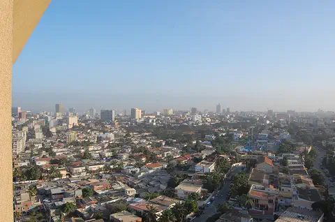
Photo: Lars Rohwer, CC BY-SA 3.0, via Wikimedia Commons
Discover Luanda
Luanda is the capital city of Angola. It is on the coast, by the Atlantic Ocean.
More than eight million people live there. That is more than in any other city in Angola!
Luanda is the capital of Angola, a country on the Atlantic coast of southern Africa. It is by far the country's largest city.
Angola's census of September 2024 counted 8,642,051 people in the city of Luanda. The next biggest city, Lubango, had 805,272, so Luanda is more than ten times bigger.
City Population's tables give Luanda 475,328 people in the 1970 census and, from Angola's National Statistics Institute (INE), 6,759,313 in 2014 and 8,642,051 in the census of 19 September 2024. The wider urban area counted 10,203,336.
Luanda Province, from which the new province of Icolo e Bengo was split, had 8,665,510 people in 2024. Angola as a whole counted 36,604,681.
- Country
- Angola (its capital)
- People in Luanda (2024 census)
- 8,642,051
- People in the 2014 census
- 6,759,313
- Founded
- 1575
A low town and a high town
Part of Luanda is down low, beside the bay. Another part is up high, on flat land above a steep slope.
Long ago, the city started as a fort.
Luanda began as a fortified trading post, the Fortress of São Miguel. Today the encyclopedia Universalis describes the city in parts. The lower town, called the baixa, lies on a narrow plain along the bay; it is home to the city's main business and banking, much of it in skyscrapers. A boulevard runs along the seafront.
The upper town spreads over a plateau above a steep slope. It is more residential, with low houses and tall buildings side by side.
Universalis (Pierre Vennetier) describes three kinds of townscape. The baixa, or lower town, occupies a narrow coastal plain along the bay; its business and financial life depends on the port, and skyscrapers have replaced older low, heavy buildings. A seafront boulevard follows the coast.
The upper town stands on a plateau that overlooks the baixa from a steep, gullied slope; many of its buildings have arcades at street level with shops. Around the city runs a belt of muceques, neighborhoods of small, mostly wooden houses, pushed ever farther out as the upper town spreads; Universalis notes that the belt is broken only by a military camp and the airport.
- Fortress of São Miguel
- the fortified trading post the city began as
- Lower town (baixa)
- a narrow coastal plain along the bay
- Upper town
- on a plateau above a steep slope
From fort to capital
Long ago, people from Portugal built a fort at Luanda.
The town grew and grew. Now it is the capital of Angola.
Luanda was founded by the Portuguese in 1575, as a base on the coast guarding the trail toward the Congo basin. It was first called São Paulo de Loanda. It began as a fortified trading post and later became a port from which enslaved people were shipped away.
The city grew slowly at first: Universalis says it had only about 50,000 people in 1930. Angola became independent in 1975, and Luanda is its capital. Universalis notes that the civil wars of 1975 to 2002 disrupted the economy.
Universalis says Luanda was founded in 1575 as a coastal base protecting the trail toward the Congo basin, and calls it the oldest town of European origin in tropical Africa. It was first a fortified trading post, the fort of São Miguel, and then a port where enslaved people were put on ships.
Growth came late: about 50,000 people in 1930 and 225,000 in 1960 (Universalis), then 475,328 at the 1970 census. Angola, a former Portuguese colony, became independent on 11 November 1975; Universalis adds that the civil wars of 1975–2002 disorganized the economy.
- Old names
- São Paulo de Loanda, or Loanda
- Universalis calls it
- the oldest town of European origin in tropical Africa
- Angola independent
- 11 November 1975
Ships, trains and planes
Ships come to Luanda's port.
A train line goes from Luanda east to another city, and planes fly to other countries.
Luanda's port lies on the bay, and Universalis says the prosperity of the lower town's businesses is tied to it. A railway starts in the city and runs east toward the town of Malanje.
The city also has an international airport, so people can fly from Luanda to other countries.
Universalis notes that the baixa's prosperity is tied to the port, that a large industrial zone lies east of the city behind the port, and that coffee, cotton and iron ore are the main exports passing through it.
Luanda is the head of a railway line running east toward Malanje, and it has an international airport (Universalis).
- Port
- on the bay; Universalis names coffee, cotton and iron ore as its main exports
- Railway
- starts in Luanda and runs east toward Malanje
- Airport
- international
Warm all year
Luanda is warm all through the year.
It is hottest from February to April and cooler in July and August.
Luanda is warm all year. The World Meteorological Organization's averages for 1961 to 1990 show daytime highs of about 31 °C in March, the warmest month, and about 24 °C in July and August, the coolest.
Nights stay mild all year: the lowest monthly average is about 19 °C, in July.
The WMO's climate table for Luanda, supplied by Angola's national weather service, gives average daily highs and lows for 1961–1990: highs from 30.2 to 30.7 °C in February to April and 23.9 °C in July and August, and lows from 24.7 °C in February down to 18.7 °C in July. The gap between the warmest and coolest month's highs is under 7 °C.
The WMO table lists no precipitation figures for Luanda, so none are given here.
- March, average high (WMO, 1961–1990)
- 30.7 °C
- July, average high (same period)
- 23.9 °C
- July, average low (same period)
- 18.7 °C
Offices, factories and the port
Luanda has offices, factories and a port.
Many offices are in tall buildings near the bay.
Universalis calls Luanda the main center of Angola's economy. Many businesses and banks have their offices in skyscrapers in the lower town.
Factories are spread across the city, with a large area set aside for them east of the port. They make foods, textiles and other everyday goods, and there is also an oil refinery.
Universalis describes industry spread across the city, with a large zone reserved for it east of the city, behind the port, and a fairly varied mix of food, textile, consumer-goods, small metalworking and oil-refining firms. Coffee, cotton and iron ore are named as the main exports passing through the port.
Universalis also notes that many of the muceque neighborhoods grew up on their own, without planning, and so have no shared public facilities.
- Economy
- the country's main economic center
- Industry
- a large zone east of the city, behind the port
- Firms
- food, textiles, consumer goods, small metalworking and an oil refinery
Luanda on the map
Find Africa on the globe. Look at its west coast, south of the equator. Luanda is right by the ocean!
The country around it is Angola.
Luanda lies on the Atlantic coast of northern Angola, at about 9° south of the equator. Part of the city lies on a narrow coastal plain along the bay, and part on a plateau above it.
Off the shore lies the Ilha de Luanda, a spit of land. Measured from the Fortress of São Miguel, Wikidata's point for Luanda Bay is about 5 kilometers to the northeast.
Luanda lies at about 8.8° S and 13.2° E on the Atlantic coast. Measured from the Fortress of São Miguel (Wikidata points), the point for the Ilha de Luanda spit is about 4.0 km northeast, the point for Luanda Bay about 5.0 km northeast, and Wikidata's point for the city about 3.6 km south-southeast.
The hero photo has no recorded camera position; the photographer took it from a high window (the building's edge shows at the left) on 4 February 2009, at 08:41 by the camera's clock.
- Latitude
- about 8.8° south
- Longitude
- about 13.2° east
- Fortress of São Miguel to Luanda Bay
- about 5 km northeast (Wikidata points)
Amazing facts
-
In 1930, only about fifty thousand people lived in Luanda. Now there are millions!
Luanda had about 50,000 people in 1930 and 8,642,051 in the 2024 census.
Universalis puts Luanda at only about 50,000 people in 1930; Angola's 2024 census counted 8,642,051, more than 170 times as many.
-
Luanda is more than ten times bigger than the next biggest city in Angola!
In the 2024 census Luanda had 8,642,051 people and Lubango, the next biggest city, 805,272.
Angola's 2024 census gives Luanda 8,642,051 people and Lubango 805,272, so the capital is more than ten times the size of the second city.
-
Luanda's old name was São Paulo de Loanda.
Luanda was once called São Paulo de Loanda, or just Loanda.
Universalis records the city's former names as São Paulo de Loanda and Loanda.
-
A train line starts in Luanda and goes east.
A railway starts in Luanda and runs east toward the town of Malanje.
Universalis describes Luanda as the head of a railway line running east toward Malanje.
Words to know
- capital
- the city where a country's government is based
- census
- an official count of all the people in a country
- fortress
- a strong building with thick walls, built to protect a place
- plateau
- a large area of high, flat land
- spit
- a long, narrow strip of land that sticks out into the sea
- refinery
- a factory where crude oil is turned into fuels such as gasoline
Discovery challenge
-
Luanda is the capital of which country?
Luanda is the capital of which country?
Luanda is the capital of which country, independent since 1975?
- Angola
- Namibia
- Zambia
Show the answer
Angola
Angola!
Angola, on the Atlantic coast of Africa.
Angola, independent from Portugal since 1975.
-
Which ocean is next to Luanda?
Luanda lies on the coast of which ocean?
On which ocean's coast does Luanda stand, beside its bay?
- The Indian Ocean
- The Pacific Ocean
- The Atlantic Ocean
Show the answer
The Atlantic Ocean
The Atlantic Ocean!
The Atlantic, on Africa's west coast.
The Atlantic Ocean, on the coast of northern Angola.
-
How did Luanda begin, long ago?
What did Luanda begin as in the 1570s?
According to Universalis, what was Luanda first, before it became a port and capital?
- A fort and trading post
- A farm
- A mountain village
Show the answer
A fort and trading post
A fort!
A fortified trading post, the Fortress of São Miguel.
A fortified trading post (the fort of São Miguel) on the coast.
-
About how many people did Angola's 2024 count find in Luanda?
About how many people did the 2024 census count in Luanda?
Which figure is closest to Luanda's population in the census of September 2024?
- About 800,000
- About 8.6 million
- About 86 million
Show the answer
About 8.6 million
More than eight million!
8,642,051 people.
8,642,051 (up from 6,759,313 in 2014).
-
Which month is the hottest in Luanda?
Which month has Luanda's highest average daytime temperature?
In the WMO's 1961–1990 table, which month has Luanda's highest average high (30.7 °C)?
- July
- March
- October
Show the answer
March
March!
March, at about 31 °C. July is the coolest.
March (30.7 °C); July and August are the coolest (23.9 °C).
Nearby places
-
 Watch
Natural wonder
River Congo
The Congo is Africa's second-longest river, about 4,700 kilometers long. It curves in a giant arc through the rainforests of central Africa and empties into the Atlantic Ocean. Rain falls in its basin all year, so it carries a huge amount of water, and its wild lower rapids are home to about 320 kinds of fish, about 90 of them found nowhere else.
-
 Watch
City
Kinshasa
Kinshasa is the capital and largest city of the Democratic Republic of the Congo. It stands on the south bank of the Congo River, about 515 kilometers from the Atlantic Ocean, facing the city of Brazzaville across the water. It grew from fishing and trading villages and was called Léopoldville until 1966.
-
 Watch
City
Brazzaville
Brazzaville, capital of the Republic of the Congo, lies on the Pool Malebo, a lake on the Congo River, facing Kinshasa across the water. It began as a small post in October 1880. The 2023 census counted 2,138,236 people in the commune of Brazzaville (preliminary figures).
-
 Watch
City
São Tomé
São Tomé is the capital of São Tomé and Príncipe, a small country of volcanic islands in the Atlantic Ocean, just north of the equator. The city curves around Ana Chaves Bay. In the 2024 census, 80,647 people were counted in its district, Água Grande.
-
 Watch
City
Yaoundé
Yaoundé is the capital of Cameroon, in Central Africa. Cameroon's official projection gives the city 3,762,900 people at the start of 2025, the second-most in the country after Douala. It grew from a German military post of the late 19th century, among hills 700 to 1,100 meters high.
-
 Watch
Landmark
Tsodilo
Tsodilo is a small group of rocky hills in the Kalahari Desert of Botswana. With more than 4,500 rock paintings in an area of only 10 square kilometers, it has been called the 'Louvre of the Desert'. People have used these hills for at least 100,000 years.
-
 Watch
City
Douala
Douala is the main port of Cameroon, on the estuary of the Wouri River near the Gulf of Guinea. The encyclopedia Larousse calls it the country's economic capital, a center of trade and industry. Cameroon's 2005 census counted 1,906,962 people in the city.
-
 Watch
Natural wonder
Okavango Delta
The Okavango Delta, in northwestern Botswana, is a huge wetland in the middle of a dry land. The Okavango River flows in from Angola, spreads out into channels, lagoons and grassy plains, and then soaks away into the sands of the Kalahari instead of reaching the sea. Its flood arrives in the dry season, drawing elephants, buffalo, zebras and many other animals.
Explore next
-
Watch
 Country
Angola
Angola is a large country in southwestern Africa, on the Atlantic Ocean. A narrow coast rises steeply to high plateaus, rivers such as the Cuanza run to the sea, and the Namib Desert reaches its far southwest. Its national statistics institute projects about 38.8 million people for 2026.
-
Watch
City
Kinshasa
Kinshasa is the capital and largest city of the Democratic Republic of the Congo. It stands on the south bank of the Congo River, about 515 kilometers from the Atlantic Ocean, facing the city of Brazzaville across the water. It grew from fishing and trading villages and was called Léopoldville until 1966.
-
 Watch
City
Cape Town
Cape Town, South Africa's oldest city, sits between Table Bay and Table Mountain. It is one of the country's three capitals, the seat of Parliament. The 2022 census counted 4,772,846 people in the City of Cape Town, and the mountains around it are part of one of the richest plant regions on Earth.
- Watch Geography Capital cities A capital is the city where a country's government is based. Many capitals grew up over hundreds of years beside rivers and trade routes. A few, like Brasília and Canberra, were built from scratch, and some countries share out their capital's jobs among two or three cities.
-
 Watch
City
Windhoek
Windhoek is the capital of Namibia. It lies about 1,700 meters above the sea in a dry, hilly land. Namibia's 2023 census counted 486,186 people in Windhoek, about four times as many as in Rundu, the next-largest town.
-
Watch
City
Brazzaville
Brazzaville, capital of the Republic of the Congo, lies on the Pool Malebo, a lake on the Congo River, facing Kinshasa across the water. It began as a small post in October 1880. The 2023 census counted 2,138,236 people in the commune of Brazzaville (preliminary figures).
-
Watch
City
São Tomé
São Tomé is the capital of São Tomé and Príncipe, a small country of volcanic islands in the Atlantic Ocean, just north of the equator. The city curves around Ana Chaves Bay. In the 2024 census, 80,647 people were counted in its district, Água Grande.
-
 Watch
City
Abidjan
Abidjan is the largest city of Côte d'Ivoire, with 5,616,633 people at the 2021 census. Spread around the Ébrié Lagoon, it grew from a colonial port: a canal finished in 1950 opened the lagoon to ships, and its Plateau district is a cluster of office towers, banks and government buildings.
For parents & teachers
What children will learn
- Locate Luanda and Angola on the Atlantic coast of southern Africa.
- Describe how a coastal fort grew into a capital city of millions.
- Compare census figures from 1970, 2014 and 2024 to see how fast a city can grow.
- Read average monthly high and low temperatures for a tropical coastal city.
Recommended ages: 3 to 17 · About 15 minutes
Talk about it
- Luanda had about 50,000 people in 1930 and more than 8 million in 2024. What does a city need when it grows that fast?
- Luanda has a lower town by the bay and an upper town on a plateau. Why might shops and offices be near the port?
- Luanda began as a fort and trading post beside a bay. Why might people build a trading post beside a bay?
Try at home or in class
- Growth chart: draw bars for Luanda's population in 1930, 1960, 1970, 2014 and 2024.
- Two-level town: build a low town and a high plateau from boxes and put the port, shops and homes where Universalis describes them.
- Map trace: draw Angola's coast and mark Luanda, the bay and the Ilha de Luanda spit.
Key vocabulary: capital, census, fortress, plateau, spit, refinery
Where these facts come from
- Wikidata , Wikimedia Foundation (CC0 1.0)
- Natural Earth vector data , Natural Earth (NACIS) (Public domain)
- Angola: provinces, major cities and urban localities (censuses 1970, 2014, 2024) , City Population (Thomas Brinkhoff), from the Instituto Nacional de Estatística, Angola
- Angola: administrative division (provinces and municipalities, censuses 2014 and 2024) , City Population (Thomas Brinkhoff), from the Instituto Nacional de Estatística, Angola
- Luanda , Encyclopaedia Universalis (Pierre Vennetier)
- World Weather Information Service: Luanda climatological information , World Meteorological Organization (Instituto Nacional de Hidrometeorologia e Geofísica, Angola)
- File:Luanda feb09 ost01.jpg (Lars Rohwer, 4 February 2009) , Wikimedia Commons
- Wikimedia Commons , Wikimedia Foundation (Per file (public domain, CC0, CC BY or CC BY-SA); see each media record)
Checked, not yet human-reviewed. Last updated November 1, 2026. Spotted a mistake? Tell us.