
City Africa
Brazzaville
Brazzaville is the capital city of the Republic of the Congo. It is beside the huge Congo River, and another big city, Kinshasa, is on the other side.
Brazzaville, capital of the Republic of the Congo, lies on the Pool Malebo, a lake on the Congo River, facing Kinshasa across the water. It began as a small post in October 1880. The 2023 census counted 2,138,236 people in the commune of Brazzaville (preliminary figures).
Founded in October 1880 as the post of Mfoa, Brazzaville stands on the Pool Malebo just upstream of the Kintambo rapids, where boats on the Congo must stop. It shares that crossroads of river, rail and road with Kinshasa on the opposite bank. Preliminary 2023 census figures give the commune 2,138,236 residents.
Photo: Prével EPOTA, CC BY-SA 4.0, via Wikimedia Commons
Discover Brazzaville
Brazzaville is the capital of the Republic of the Congo, in Africa. It is beside the wide Congo River.
On the other side of the river is another big city, Kinshasa.
Brazzaville is the capital of the Republic of the Congo. Universalis says it lies on the edge of the Pool Malebo, a lake on the Congo River, and that Kinshasa stands on the opposite bank; it calls the two twin cities.
The 2023 census counted 2,138,236 people in the commune of Brazzaville, according to the preliminary figures of the national statistics institute (INS) listed by City Population.
The preliminary 2023 census results (17 May 2023, INS, via City Population) give the commune of Brazzaville 2,138,236 residents: 1,057,605 men and 1,080,631 women. Talangaï (390,459) and Mfilou (387,730) were the most populous of its nine arrondissements; Poto-Poto (84,299) and Bacongo (84,353) the least.
Universalis (2022 figures) puts the wider urban area near 2 million and Pointe-Noire's near 1 million: together, half of the Congo's 6 million people, a country with two big urban poles.
- Country
- Republic of the Congo (capital)
- People in the commune (census, 17 May 2023, preliminary)
- 2,138,236
- Area (calculated by City Population)
- about 389 km²
- Across the river
- Kinshasa
A green city from the air
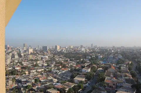
This photo was taken from high above Brazzaville. You can see many houses with white and red roofs, and lots of green trees.
A wide road with cars runs along the left side.
The photo looks down on Quartier OCH, a neighborhood of Brazzaville, from high above. A wide, divided road with cars and minibuses runs along the left side. Tall apartment blocks stand in front, low houses with white and red roofs spread out between leafy trees, and a few taller buildings, some yellow, rise farther away under a dark blue sky.
The photo was entered in Wiki Loves Africa 2022 under the theme 'Home + Habitat in Africa'.
The Commons file 'Quartier OCH' (Prével EPOTA, 29 April 2022) records its camera point at 4.2647° S, 15.2610° E, about 1.7 km south-southeast of Maya-Maya Airport by Wikidata's point. In it: a multi-lane road at the left, a parking lot and apartment towers in the foreground, a dense mix of low houses and trees, and a flat skyline with a few towers at the horizon.
Wikidata lists the Pool Malebo as a lake on the lower Congo River, and Universalis says the city sits on its edge.
- Photo
- Quartier OCH, 29 April 2022
- Pool Malebo
- lake on the lower Congo River
- Maya-Maya Airport
- about 1.7 km north-northwest of the photo's camera point
From the post of Mfoa to a capital
In 1880 an explorer named Pierre Savorgnan de Brazza set up a small post here. Later the town was named Brazzaville, after him.
Universalis dates the city's birth to October 1880, when the explorer Pierre Savorgnan de Brazza founded the post of Mfoa, following a treaty signed with Makoko, king of the Batéké. On 1 July 1881 the Société de géographie de Paris proposed naming the little post Brazzaville.
In 1903 it took over from Libreville as the chief town of French Congo, and then of French Equatorial Africa.
Universalis (2022-era text) says that for its 100th anniversary the Congolese authorities chose to keep the name of its founder, whose image is seen in a positive light. The modest colonial post's position won it the role of chief town of French Congo from Libreville in 1903, and then of French Equatorial Africa.
For a long time its trade with the outside world went through the Belgian Congo, by the Matadi–Kinshasa railway finished in 1898. Brazzaville gained its own route to the Atlantic only in 1934, when the Congo–Ocean railway and the port of Pointe-Noire were completed.
- Post of Mfoa founded
- October 1880
- Name Brazzaville proposed
- 1 July 1881, by the Société de géographie de Paris
- Chief town of French Congo
- from 1903 (taking over from Libreville)
Where the river meets the railway
Boats sail on the river to Brazzaville. A railway goes from Brazzaville all the way to the sea. And planes land at Maya-Maya Airport.
Universalis says Brazzaville sits just upstream of the Kintambo rapids, the first of a series of falls and rapids that stop boats on the lower Congo River. That makes Brazzaville and Kinshasa the place where goods move between river boats and the railways and roads.
Wikidata lists the Gare de Brazzaville as the eastern end of the Congo–Ocean Railway, opened on 10 July 1934, and Maya-Maya Airport as an airport in the Republic of the Congo.
Universalis describes Brazzaville and Kinshasa as sharing a strategic position at the break of bulk between the navigable network of the Congo and its tributaries and the railways and roads built to open up the twin cities and their hinterland.
Since the early 2000s, it says, the city has spread northeast toward Kintélé, a new town linked by an expressway, the Corniche nord, along the Pool. A Corniche sud along the river gives a fast road between the Plateau, the central district, and the southern neighborhoods; its cable-stayed bridge is lit up at night.
- Kintambo rapids
- just downstream; boats cannot go farther
- Gare de Brazzaville
- eastern end of the Congo–Ocean Railway, opened 10 July 1934
- Maya-Maya Airport
- an airport in the Republic of the Congo
A long rainy season and a dry season
Brazzaville is warm all year. It rains a lot for most of the year, but from June to August it is very dry.
The Japan Meteorological Agency's normals for the Brazzaville station show warm weather all year. The average temperature stays between about 23.5 °C in July and 27 °C in March and April.
About 1,534 millimeters of precipitation fall in an average year. November is the wettest month, with about 259 millimeters, while June, July and August together get only about 8.
The JMA's monthly normals for Brazzaville (station at 4.25° S, 15.25° E, 319 m) give mean temperatures from 23.5 °C in July to 27.0 °C in March and April, with an average of about 25.8 °C across the twelve months.
The monthly precipitation normals add up to 1,533.8 mm. October to May bring 1,482.3 mm; June to August only 8.3 mm, with July at 0.4 mm. November (259.3 mm) and December (240.6 mm) are the wettest months.
- Warmest months, average temperature (JMA normals)
- March and April, 27.0 °C
- Coolest month, average temperature (same table)
- July, 23.5 °C
- Precipitation in a year (sum of the monthly normals)
- about 1,534 mm
A growing capital
Brazzaville keeps growing. A new town with a sports center is growing to the northeast, linked by a new road.
Universalis says people from all over the Republic of the Congo have come to live in the capital, which sits where the country's northern and southern regions meet. The central district, the Plateau, holds the main government and business offices.
Since the early 2000s the city has grown toward the northeast. At Kintélé, a new town has a sports complex opened for the 2015 African Games and an international conference center.
The 2023 census table shows big differences between the nine arrondissements: Talangaï had 390,459 residents, Mfilou 387,730 and Djiri 307,848, while Poto-Poto and Bacongo had about 84,000 each.
Universalis describes newcomers settling in neighborhoods called 'villages' or 'cités' on both sides of the central Plateau, and the new Corniche roads along the Pool and the river reshaping the city's riverside.
- Most populous arrondissement (2023)
- Talangaï, 390,459
- New town to the northeast
- Kintélé
- Sports complex at Kintélé
- opened for the 2015 African Games
Brazzaville on the map
Find Africa on the globe. Near the middle, find the great Congo River. Brazzaville is on one bank, and Kinshasa is on the other!
Brazzaville lies at about 4.3° south, just south of the equator, on the Congo River. Kinshasa stands on the opposite bank.
Measured from the photo's camera point, Maya-Maya Airport is about 1.7 kilometers to the north-northwest, the Gare de Brazzaville about 3.1 kilometers to the east and Kintélé about 17 kilometers to the northeast.
Brazzaville lies at about 4.26° S and 15.28° E. Measured from the photo's camera point (Commons) to Wikidata points: Maya-Maya Airport 1.70 km north-northwest, Gare de Brazzaville 3.08 km east, Kintélé 17.35 km northeast; Wikidata's point for the middle of the Pool Malebo lies 25.31 km east.
Universalis places the capital at the hinge between the northern and southern regions of the Republic of the Congo.
- Latitude
- about 4.3° south
- Longitude
- about 15.3° east
- Camera point to the Gare de Brazzaville
- about 3.1 km east
Amazing facts
-
Two big cities face each other across the Congo River: Brazzaville and Kinshasa.
Universalis calls Brazzaville and Kinshasa twin cities: they stand on opposite banks of the Congo River, at the Pool Malebo.
Universalis says Brazzaville and Kinshasa share a strategic position where goods pass between the Congo's river boats and the railways and roads; the two cities face each other across the river.
-
In July, Brazzaville gets almost no rain.
In the Japan Meteorological Agency's normals for Brazzaville, July gets only 0.4 millimeters of precipitation, while November gets about 259.
JMA Brazzaville normals: June 3.6 mm, July 0.4 mm and August 4.3 mm, against 259.3 mm in November.
-
Brazzaville is named after an explorer.
The city is named after the explorer Pierre Savorgnan de Brazza, who founded the post of Mfoa in 1880.
The Société de géographie de Paris proposed the name Brazzaville on 1 July 1881; for the city's centenary, Universalis says, the Congolese authorities decided to keep it.
-
Boats coming down the river must stop at Brazzaville because of rapids.
Just downstream of Brazzaville, the Kintambo rapids begin a series of falls and rapids that boats cannot pass on the lower Congo River.
Universalis says the lower Congo cannot be navigated below the Kintambo rapids, and that Brazzaville long relied on the Matadi–Kinshasa railway (1898) for its trade until the Congo–Ocean line opened its own route to the sea in 1934.
Words to know
- capital
- the city where a country's government meets
- rapids
- a part of a river where the water flows fast over rocks
- twin cities
- two cities that stand close together, like on opposite banks of a river
- arrondissement
- a district of a city, with its own local office
- census
- an official count of all the people in a country
- precipitation
- water that falls from the sky as rain, snow, sleet or hail
Discovery challenge
-
Which city is across the river from Brazzaville?
Which city stands on the opposite bank of the Congo River from Brazzaville?
Universalis calls Brazzaville and which city 'twin cities' on the Pool Malebo?
- Kinshasa
- Luanda
- Nairobi
Show the answer
Kinshasa
Kinshasa!
Kinshasa.
Kinshasa, on the opposite bank.
-
Which big river is Brazzaville beside?
Brazzaville lies on the Pool Malebo, a lake on which river?
The Pool Malebo, on whose edge Brazzaville lies, is a lake on which river?
- The Nile
- The Congo
- The Niger
Show the answer
The Congo
The Congo River!
The Congo River.
The lower Congo River.
-
Who is Brazzaville named after?
Brazzaville is named after which explorer?
Which explorer founded the post of Mfoa in October 1880?
- Pierre Savorgnan de Brazza
- Henry Morton Stanley
- Ferdinand Magellan
Show the answer
Pierre Savorgnan de Brazza
Pierre Savorgnan de Brazza!
Pierre Savorgnan de Brazza.
Pierre Savorgnan de Brazza; the name Brazzaville was proposed in 1881.
-
When is Brazzaville very dry?
In which months does Brazzaville get almost no rain?
In the JMA's normals, which three months bring only 8.3 mm of precipitation together?
- June to August
- November to January
- March to May
Show the answer
June to August
June to August!
June to August.
June to August; November is the wettest month.
-
What stops boats on the river just past Brazzaville?
What stops boats from sailing farther down the Congo River past Brazzaville?
Brazzaville lies just upstream of which feature, the first of a series of falls and rapids on the lower Congo?
- Rapids
- A wall
- Ice
Show the answer
Rapids
Fast, rocky rapids!
The Kintambo rapids.
The Kintambo rapids.
Nearby places
-
 Watch
City
Kinshasa
Kinshasa is the capital and largest city of the Democratic Republic of the Congo. It stands on the south bank of the Congo River, about 515 kilometers from the Atlantic Ocean, facing the city of Brazzaville across the water. It grew from fishing and trading villages and was called Léopoldville until 1966.
-
 Watch
Natural wonder
River Congo
The Congo is Africa's second-longest river, about 4,700 kilometers long. It curves in a giant arc through the rainforests of central Africa and empties into the Atlantic Ocean. Rain falls in its basin all year, so it carries a huge amount of water, and its wild lower rapids are home to about 320 kinds of fish, about 90 of them found nowhere else.
-
 Watch
City
Luanda
Luanda is the capital of Angola, on the Atlantic coast of Africa. It began in 1575 as a Portuguese fort and trading post beside a bay, and it is now Angola's largest city: the 2024 census counted 8,642,051 people there.
-
 Watch
City
Yaoundé
Yaoundé is the capital of Cameroon, in Central Africa. Cameroon's official projection gives the city 3,762,900 people at the start of 2025, the second-most in the country after Douala. It grew from a German military post of the late 19th century, among hills 700 to 1,100 meters high.
-
 Watch
City
São Tomé
São Tomé is the capital of São Tomé and Príncipe, a small country of volcanic islands in the Atlantic Ocean, just north of the equator. The city curves around Ana Chaves Bay. In the 2024 census, 80,647 people were counted in its district, Água Grande.
-
 Watch
City
Douala
Douala is the main port of Cameroon, on the estuary of the Wouri River near the Gulf of Guinea. The encyclopedia Larousse calls it the country's economic capital, a center of trade and industry. Cameroon's 2005 census counted 1,906,962 people in the city.
-
 Watch
Natural wonder
Mount Nyiragongo
Mount Nyiragongo is a steep volcano in the Virunga Mountains of the Democratic Republic of the Congo, near the border with Rwanda and just north of Lake Kivu. It is 3,470 meters high, and its deep summit crater often holds a lake of bubbling lava. Its lava is very runny, and eruptions in 1977, 2002 and 2021 sent lava flowing down its sides toward the city of Goma.
-
 Watch
Natural wonder
Lake Tanganyika
Lake Tanganyika lies in a deep crack in Africa called a rift valley. Britannica calls it the longest freshwater lake in the world, and only Lake Baikal, in Russia, is deeper. Four countries share it: Tanzania, the Democratic Republic of the Congo, Burundi and Zambia. Its water is home to about 250 kinds of cichlid fish found nowhere else.
Explore next
-
 Watch
 Country
Republic of the Congo
The Republic of the Congo lies on the equator in west-central Africa. Thick rainforests cover much of it, the mighty Congo River forms its eastern border, and it has a short coast on the Atlantic Ocean. Forest elephants and gorillas live in its parks. About 6.5 million people lived there in 2025, most of them in two cities.
-
Watch
City
Kinshasa
Kinshasa is the capital and largest city of the Democratic Republic of the Congo. It stands on the south bank of the Congo River, about 515 kilometers from the Atlantic Ocean, facing the city of Brazzaville across the water. It grew from fishing and trading villages and was called Léopoldville until 1966.
-
Watch
City
Luanda
Luanda is the capital of Angola, on the Atlantic coast of Africa. It began in 1575 as a Portuguese fort and trading post beside a bay, and it is now Angola's largest city: the 2024 census counted 8,642,051 people there.
-
Watch
Natural wonder
River Congo
The Congo is Africa's second-longest river, about 4,700 kilometers long. It curves in a giant arc through the rainforests of central Africa and empties into the Atlantic Ocean. Rain falls in its basin all year, so it carries a huge amount of water, and its wild lower rapids are home to about 320 kinds of fish, about 90 of them found nowhere else.
-
Watch
City
Yaoundé
Yaoundé is the capital of Cameroon, in Central Africa. Cameroon's official projection gives the city 3,762,900 people at the start of 2025, the second-most in the country after Douala. It grew from a German military post of the late 19th century, among hills 700 to 1,100 meters high.
-
 Watch
City
Abidjan
Abidjan is the largest city of Côte d'Ivoire, with 5,616,633 people at the 2021 census. Spread around the Ébrié Lagoon, it grew from a colonial port: a canal finished in 1950 opened the lagoon to ships, and its Plateau district is a cluster of office towers, banks and government buildings.
-
 Watch
City
Abuja
Abuja is the capital of Nigeria, in the middle of the country. It was planned from the start: in 1976 the government decided to build a new capital on the savanna, and in 1991 it moved there from Lagos. Planners set aside land for parks and green spaces, and the huge Aso Rock rises at the city's edge.
-
 Watch
City
Accra
Accra is the capital of Ghana, on the coast of West Africa. It began as a small village of the Ga people beside the Korle Lagoon. Three old forts built by European traders still stand by the sea. More than 5.4 million people lived in the Greater Accra Region at the 2021 census.
For parents & teachers
What children will learn
- Locate Brazzaville and Kinshasa on opposite banks of the Congo River.
- Explain why rapids make a place where goods change from boats to trains.
- Read a climate with a long rainy season and a short dry season.
- Compare district populations from a census table.
Recommended ages: 3 to 17 · About 15 minutes
Talk about it
- Brazzaville and Kinshasa face each other across a river. What might it be like to live in a city where another capital is in sight?
- Boats cannot pass the rapids below Brazzaville. How do rivers, rapids and railways decide where cities grow?
- Almost no rain falls from June to August. How might people, farms and rivers change between the wet and dry seasons?
Try at home or in class
- Rain chart: plot Brazzaville's monthly precipitation and color the dry months.
- District bars: draw a bar chart of the nine arrondissements' populations from the 2023 census.
- River map: draw the Congo River, the Pool Malebo, Brazzaville and Kinshasa, and mark where the rapids begin.
Key vocabulary: capital, rapids, twin cities, arrondissement, census, precipitation
Where these facts come from
- Wikidata , Wikimedia Foundation (CC0 1.0)
- Natural Earth vector data , Natural Earth (NACIS) (Public domain)
- Brazzaville: Arrondissements (2023 census, preliminary) , City Population (Thomas Brinkhoff), from the Institut National de la Statistique
- Brazzaville , Encyclopaedia Universalis
- Normals: Brazzaville, Congo (Rep.) , Japan Meteorological Agency
- File:Quartier OCH.jpg (Prével EPOTA, 29 April 2022) , Wikimedia Commons
- Wikimedia Commons , Wikimedia Foundation (Per file (public domain, CC0, CC BY or CC BY-SA); see each media record)
Checked, not yet human-reviewed. Last updated November 1, 2026. Spotted a mistake? Tell us.