
Natural wonder Africa
River Congo
The Congo is a huge river in Africa. It flows through a giant rainforest. It carries lots and lots of water to the ocean.
The Congo is Africa's second-longest river, about 4,700 kilometers long. It curves in a giant arc through the rainforests of central Africa and empties into the Atlantic Ocean. Rain falls in its basin all year, so it carries a huge amount of water, and its wild lower rapids are home to about 320 kinds of fish, about 90 of them found nowhere else.
The Congo drains about 3.46 million km² of central Africa and discharges about 41,000 m³/s, far less than the Amazon but still enormous. Thirty-two cataracts below Malebo Pool block navigation to the sea, and in that turbulent lower river scientists measured depths of about 220 m, which they say may make it the world's deepest river, and counted some 320 fish species.
Photo: Bsm15, CC BY-SA 3.0, via Wikimedia Commons
Discover the Congo
The Congo is a giant river in the middle of Africa.
It flows through a huge, green rainforest. It makes a big curve before it reaches the ocean. Two big cities sit across the river from each other.
The Congo River is the second-longest river in Africa, after the Nile, at about 4,700 kilometers. Its farthest source is the Chambeshi River in the highlands of northeastern Zambia. From there it flows in a giant counterclockwise arc, first northwest, then west, then southwest, until it reaches the Atlantic Ocean.
Its basin, all the land that drains into it, covers about 3.46 million square kilometers, almost all of the Democratic Republic of the Congo and much of the Republic of the Congo, the Central African Republic, Zambia and Angola. The basin holds the world's second-largest rainforest. Two capital cities, Kinshasa and Brazzaville, face each other across a wide part of the river called Malebo Pool.
Britannica gives the Congo a length of about 4,700 km and a basin of some 3,457,000 km², taking in almost all of the Democratic Republic of the Congo, most of the Republic of the Congo and the Central African Republic, eastern Zambia, northern Angola and parts of Cameroon and Tanzania. The Chambeshi, rising at 1,760 m between Lakes Tanganyika and Nyasa, is the remotest source, but the Lualaba carries the most water, so either can be called the original main stream.
The Congo and the Amazon are the world's two great rivers flowing out of equatorial zones with rain in almost every month. Upstream of Malebo Pool the basin receives about 1,500 mm of rain a year, more than a quarter of which reaches the Atlantic. The basin is about half the size of the Amazon's, and the Congo's flow of about 41,000 m³/s at its mouth is far less than the Amazon's. With its tributaries it forms Africa's largest network of navigable waterways, about 14,000 km within the DR Congo alone.
- Length
- about 4,700 km
- Basin area
- about 3,457,000 km²
- Flow at the mouth
- about 41,000 m³/s
- Source (farthest)
- Chambeshi River, highlands of northeastern Zambia
- Mouth
- Atlantic Ocean, at Banana (DR Congo)
A giant bowl, waterfalls and rapids
The middle of the Congo's land is shaped like a giant, shallow bowl.
Rivers flow down into the bowl from all sides. The Congo rushes over waterfalls, then flows slowly and widely. Near the sea it crashes through wild rapids.
The center of the Congo basin is a huge, shallow depression, like a saucer. For hundreds of millions of years, mud and sand have washed into it from the higher land all around. Rivers flow down its slopes from every side, like the ribs of a fan, and meet in the Congo.
The river has three parts. In the upper Congo, rivers join, widen into lakes and tumble over rapids, such as Boyoma Falls near Kisangani. In the middle Congo, the river flows calmly for more than 1,600 kilometers, sometimes 8 to 13 kilometers wide, dotted with islands. Below Malebo Pool, the lower Congo races through 32 cataracts and rapids before it reaches the sea.
Britannica describes the central cuvette (saucer) as an immense depression of Quaternary alluvium over thick continental sands and sandstones; boreholes show sediment accumulating since at least 570 million years ago, evidence of persistent subsidence, with uplift on the eastern rim influenced by the Western Rift Valley. Tributaries descend concentric slopes of 275 to 460 m toward the center.
The upper Congo is a series of confluences, lakes (Upemba, Bangweulu, Mweru, Tanganyika) and rapids. Below Boyoma Falls, seven cataracts ending at Kisangani, the navigable middle Congo runs more than 1,600 km, splitting into arms between islands and widening to 8 to 11 km, once 13 km, before narrowing through the Chenal, cut hundreds of meters into the sandstone of the Batéké Plateau. The Ubangi, Sangha and Kwa raise the flow from under 7,000 m³/s at Kisangani to nearly the maximum at Kinshasa. Below Malebo Pool, 32 cataracts, including Inga Falls, drop the river from about 275 m to near sea level; the 134 km estuary from Matadi forms the Angola-DR Congo border, and offshore the river continues as a submarine canyon about 200 km long. Fed by rain on both sides of the Equator, its flow is unusually regular.

Fish found nowhere else
Hundreds of kinds of fish live in the Congo.
Some live only here and nowhere else. Some are white and blind. Forest elephants, bonobos and lots of birds live in the forest beside the river.
The Congo is full of fish. Scientists from the American Museum of Natural History have found about 320 kinds in just the last 350 kilometers of the river, and about 90 of them live nowhere else. Scientists think the wild rapids act like walls that keep groups of fish apart, so new species can form. One strange fish is white and blind and is thought to live deep in the river.
More than 265 kinds of forest birds have been recorded in the Congo region, and hippos live in the river. In the northwest of the basin, UNESCO protects forests with large numbers of forest elephants. The river also separates two kinds of apes: chimpanzees live north of it, and bonobos live only south of it.
Britannica notes more than 230 fish species in Malebo Pool and its inflows alone, lungfish that survive dry spells in mucus cocoons in drying swamps, and black catfish matching tea-colored marsh water. The American Museum of Natural History reports about 320 species in the lower Congo's 350 km, 90 of them endemic, compared with about 115 in the much longer Upper Nile. Its researchers propose that the rapids isolate fish populations, speeding speciation: two populations of Teleogramma brichardi from opposite banks look alike yet differ by about 5 percent in a DNA section. The blind, colorless Lamprologus lethops is always found dead or dying at the surface; one that died in Stiassny's hand had gas bubbles in its skin and gills, which led the team to suspect it lives at great depth.
The river shapes other animals' ranges too: AMNH notes that common chimpanzees live only north of the Congo and bonobos only south of it, a split biologists suspect began at least 800,000 years ago. Britannica records more than 265 equatorial-forest bird species, migrants from Europe, and rare aquatic mammals: hippopotamus, two otter species and the manatee, confirmed only on the Sangha. In the northwestern basin, the Sangha Trinational World Heritage site (which includes Nouabalé-Ndoki National Park) protects large populations of forest elephants.

Fishing, boats and power
Many people along the Congo catch fish.
They use traps, nets and boats. They grow cassava on land beside the river. Big boats carry goods up and down the river, because there are few roads.
Almost all the peoples living along the Congo fish. At Boyoma Falls, the Enya people tie fish traps to poles set right in the rapids. In the marshes, the Ngombe, whose name means water people, fish in the flooded forest. People also build dikes, banks of earth, to grow cassava on land safe from floods.
The river is also a road. Few roads and bridges cross the region, so boats carry farm goods, wood and fuel between towns. Railways built in 1898 and 1934 carry goods around the rapids to the sea. Europeans once called the river the Zaire, from a local word meaning simply river; its modern name comes from the old Kingdom of Kongo.
Britannica describes three river environments, narrow sections, island-studded reaches and floodplain marshes, each with its own fishing: the Enya (Wagenia) at Boyoma Falls and the Manyanga below Malebo Pool attach traps to stakes in the rapids, while marsh peoples such as the Ngombe fish the flooded forests. Cultivators raise dikes, sometimes of monumental size, to grow cassava, sweet potatoes, bananas and yams, and the growth of Kinshasa and Brazzaville has tied fishing to a cash economy.
The DR Congo has some 14,000 km of navigable waterway, but traffic is modest and has declined since independence in 1960; the Ilebo-Kinshasa route still carries Katanga's copper toward the coast. The Matadi-Kinshasa railway (1898) and the Congo-Ocean line from Brazzaville to Pointe-Noire (1934) bypass the cataracts. Europeans who reached the river at the end of the 15th century called it the Zaire, a corruption of a local word for river; the name Congo, from the Kingdom of Kongo, came into use in the early 18th century. Britannica estimates the basin's hydroelectric potential at about one-sixth of the world's known resources, with more than 30,000 MW at Inga alone, where Inga I and II have been built.

Visiting safely
Parts of the Congo are very fast and wild.
Big whirlpools can tip over small boats. Stay close to a grown-up and wear a life jacket. Never drink river water.
Much of the Congo flows calmly, but below Malebo Pool its rapids are, in the words of the American Museum of Natural History, the world's most extreme. The museum describes huge whirlpools and water bursting up from the depths that can easily tip over small boats.
Anyone in a boat, even on calm stretches, should wear a life jacket; the US Centers for Disease Control and Prevention (CDC) says it lowers the risk of drowning for every age and swimming level. Around the river, children need their own life jacket and an adult keeping a close eye on them. The CDC also warns that river water can look clean but still make people sick, so travelers drink only sealed bottled water or water that has been properly treated.
The American Museum of Natural History describes the lower Congo below Malebo Pool as spilling about 50,000 m³/s down a steep gorge into what it calls the world's most extreme rapids, with large whirlpools and upwellings that easily capsize small boats; during the 2008 survey a whirlpool fully submerged a 2.7 m kayak. Britannica notes the 32 cataracts make that stretch unnavigable.
Elsewhere on the river the CDC's general advice holds: currents may be hidden, a life jacket lowers drowning risk for any boater, children near natural water need one and constant adult supervision, and inflatable toys offer no real protection. The CDC Yellow Book adds that water contaminated by sewage or runoff can appear clear and that swallowing even small amounts can cause illness; where tap water could be unsafe, use only factory-sealed bottled or properly disinfected water.
Amazing facts
-
A blind white fish lives deep in the Congo.
A small, white, blind fish from the lower Congo is almost always found dead, floating at the surface. Scientists think it lives very deep down.
Lamprologus lethops, blind and colorless, is always found dead or dying at the surface; one that died in a researcher's hand had gas bubbles in its skin and gills, which led AMNH scientists to suspect it lives at great depth.
-
The name Zaire just means river.
Early European visitors called the Congo the Zaire, from a local word that simply means river.
Zaire comes from a local word variously given as nzari, nzali, njali, nzaddi or niadi, meaning river; Rio Congo, after the Kingdom of Kongo, came into use in the early 18th century.
-
Some fish in the Congo sleep through dry times in a cozy cocoon.
When the swamps beside the Congo dry up, lungfish bury themselves and survive inside a cocoon of slime until the water returns.
Britannica describes lungfish in the riverine swamps surviving dry periods buried and encysted in cocoons of mucus.
-
The Congo keeps flowing out under the sea.
Past its mouth, the Congo continues under the ocean as a deep underwater canyon about 200 kilometers long.
Beyond the estuary, the Congo's course continues offshore as a deep submarine canyon extending about 200 km.
Words to know
- basin
- all the land whose rain and streams drain into one river
- rapids
- a part of a river where the water flows very fast over rocks
- cataract
- a large waterfall or a steep stretch of rapids
- estuary
- the wide mouth of a river, where fresh water meets the sea
- endemic
- found in one place and nowhere else in the world
- rainforest
- a thick forest with rain in almost every month of the year
- speciation
- the slow process by which one kind of living thing becomes two
Discovery challenge
-
Into which ocean does the Congo flow?
Which ocean does the Congo River empty into?
Into which ocean does the Congo discharge at Banana?
- The Atlantic Ocean
- The Indian Ocean
- The Arctic Ocean
Show the answer
The Atlantic Ocean
The Atlantic Ocean, on Africa's west side.
The Congo flows in a big arc and empties into the Atlantic Ocean.
The Atlantic; offshore its course continues as a submarine canyon about 200 km long.
-
Which African river is longer than the Congo?
The Congo is Africa's second-longest river. Which river is longer?
Which river is the only one in Africa longer than the Congo, according to Britannica?
- The Nile
- The Niger
- The Zambezi
Show the answer
The Nile
The Nile is longer.
The Nile is Africa's longest river; the Congo, about 4,700 kilometers, is second.
The Nile; Britannica ranks the Congo, at about 4,700 km, second in Africa.
-
Which ape lives only south of the Congo River?
Which ape lives only on the south side of the Congo River?
Which ape species does AMNH say lives only south of the Congo?
- The bonobo
- The gorilla
- The orangutan
Show the answer
The bonobo
The bonobo! Chimpanzees live on the north side.
Bonobos live only south of the river, and chimpanzees only north of it.
The bonobo (Pan paniscus); the common chimpanzee lives only to the north.
-
What keeps the Congo full of water all year?
Why does the Congo have such a steady flow all year?
What gives the Congo its unusually regular flow regime?
- Rain falls in its basin all year
- Snow melts in the mountains
- Sea water flows in
Show the answer
Rain falls in its basin all year
Rain! It rains there all year.
Rain falls on both sides of the Equator in its basin, so some part of the river is always being filled.
Year-round rains over a basin spanning both sides of the Equator; the tributaries' floods arrive at different times.
-
What can the big whirlpools in the lower Congo do?
What danger do the whirlpools of the lower Congo pose to boats?
According to the American Museum of Natural History, what can the lower Congo's whirlpools and upwellings do?
- Tip over small boats
- Make the water warm
- Stop the river from flowing
Show the answer
Tip over small boats
They can tip over small boats. Stay safe with a grown-up and a life jacket.
Huge whirlpools and water bursting up from below can easily capsize small boats.
They easily capsize small boats; in 2008 a whirlpool fully submerged a 2.7 m kayak during the survey.
Nearby places
-
 Watch
Natural wonder
Okavango Delta
The Okavango Delta, in northwestern Botswana, is a huge wetland in the middle of a dry land. The Okavango River flows in from Angola, spreads out into channels, lagoons and grassy plains, and then soaks away into the sands of the Kalahari instead of reaching the sea. Its flood arrives in the dry season, drawing elephants, buffalo, zebras and many other animals.
-
 Watch
Natural wonder
Lake Tanganyika
Lake Tanganyika lies in a deep crack in Africa called a rift valley. Britannica calls it the longest freshwater lake in the world, and only Lake Baikal, in Russia, is deeper. Four countries share it: Tanzania, the Democratic Republic of the Congo, Burundi and Zambia. Its water is home to about 250 kinds of cichlid fish found nowhere else.
-
 Watch
Natural wonder
Namib
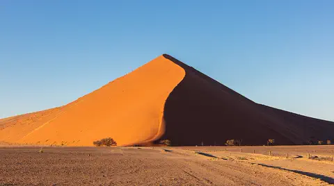
The Namib is a cool desert that runs for about 1,900 kilometers along Africa's Atlantic coast, from Angola through Namibia into South Africa. It gets almost no rain, but cold ocean water makes thick fog that drifts inland. UNESCO says its Namib Sand Sea is the only coastal desert in the world with huge dune fields influenced by fog.
-
 Watch
Natural wonder
Mount Nyiragongo
Mount Nyiragongo is a steep volcano in the Virunga Mountains of the Democratic Republic of the Congo, near the border with Rwanda and just north of Lake Kivu. It is 3,470 meters high, and its deep summit crater often holds a lake of bubbling lava. Its lava is very runny, and eruptions in 1977, 2002 and 2021 sent lava flowing down its sides toward the city of Goma.
-
 Watch
Natural wonder
Victoria Falls
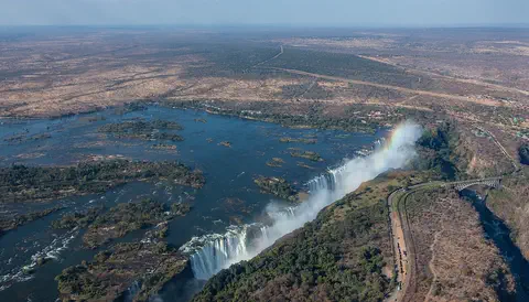
Victoria Falls, on the Zambezi River between Zambia and Zimbabwe, is about 1,708 meters wide and up to 108 meters deep. UNESCO calls it the largest curtain of falling water in the world, and its spray can be seen from tens of kilometers away.
-
 Watch
Natural wonder
Virunga National Park
Virunga National Park, in the east of the Democratic Republic of the Congo, was founded in 1925; the park describes itself as Africa's first national park. It stretches from active volcanoes in the south to the snowy Rwenzori Mountains in the north. About one third of the world's mountain gorillas live in its forests, along with elephants, hippos, chimpanzees and hundreds of kinds of birds.
-
 Watch
Natural wonder
Kalahari Desert
The Kalahari is a giant sandy plain in southern Africa, covering almost all of Botswana and parts of Namibia and South Africa. It stretches about 1,600 kilometers from north to south. Its southwest is a true desert, with long red dunes, while its north is green with woodlands and even has a huge swamp, the Okavango Delta.
-
 Watch
Natural wonder
Lake Victoria
Lake Victoria is the largest lake in Africa, and Britannica says only Lake Superior, in North America, is a bigger freshwater lake. It is shared by Kenya, Tanzania and Uganda. The lake is wide but shallow, its only outlet is the Nile, and it is home to hundreds of kinds of colorful fish called cichlids.
Experiments to try
Explore next
-
Watch
 Country
Democratic Republic of the Congo
The Democratic Republic of the Congo, or DR Congo, is the second-largest country in Africa. The mighty Congo River curves through its rainforests, volcanoes rise in the east, and its capital, Kinshasa, is a center of music, fashion and popular culture.
-
Watch
 Country
Republic of the Congo
The Republic of the Congo lies on the equator in west-central Africa. Thick rainforests cover much of it, the mighty Congo River forms its eastern border, and it has a short coast on the Atlantic Ocean. Forest elephants and gorillas live in its parks. About 6.5 million people lived there in 2025, most of them in two cities.
-
Watch
 Country
Zambia
Zambia is a landlocked country on a high plateau in south-central Africa, named after the Zambezi River. On its southern border the Zambezi thunders over Victoria Falls. About 22 million people live there, and its copper mines have long made it one of Africa's great copper producers.
-
 Watch
 Country
Angola
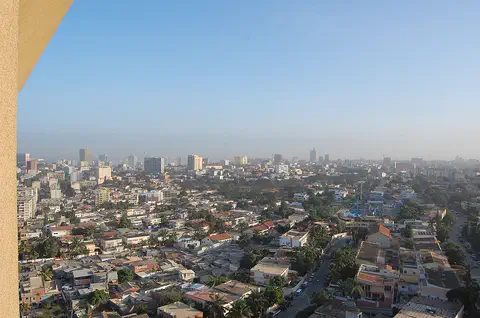
Angola is a large country in southwestern Africa, on the Atlantic Ocean. A narrow coast rises steeply to high plateaus, rivers such as the Cuanza run to the sea, and the Namib Desert reaches its far southwest. Its national statistics institute projects about 38.8 million people for 2026.
-
Watch
Natural wonder
Lake Tanganyika
Lake Tanganyika lies in a deep crack in Africa called a rift valley. Britannica calls it the longest freshwater lake in the world, and only Lake Baikal, in Russia, is deeper. Four countries share it: Tanzania, the Democratic Republic of the Congo, Burundi and Zambia. Its water is home to about 250 kinds of cichlid fish found nowhere else.
-
 Watch
Natural wonder
Amazon River
The Amazon River flows from tiny streams in the Andes Mountains of Peru across Colombia and Brazil to the Atlantic Ocean. NASA calls it the largest river in the world: about 219,000 cubic meters of water pour into the ocean every second, nearly a fifth of all the water that rivers carry to the oceans.
-
 Watch
Natural wonder
Nile
The Nile flows north through northeastern Africa to the Mediterranean Sea, and its basin is shared by 11 countries. Its length is usually given as about 6,650 kilometers. Two great branches, the White Nile and the Blue Nile, meet at Khartoum in Sudan, and the green strip of farmland along its banks made it the lifeline of ancient Egypt.
-
 Watch
Animal
Bonobo
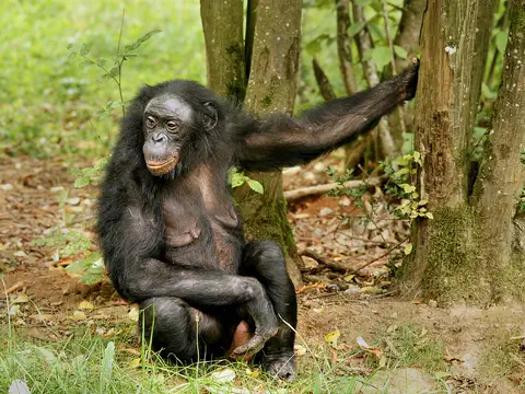
The bonobo is a great ape that looks a lot like a chimpanzee but is more slender, with a rounder head. It lives only in the rainforests south of the Congo River, in groups where females take the lead and squabbles rarely turn into fights.
For parents & teachers
What children will learn
- Trace the Congo's arc from Zambia through central Africa to the Atlantic.
- Explain why an equatorial river has a steady flow all year.
- Describe how rapids can separate fish populations and help new species form.
- Describe how people along the river fish, farm and travel.
Recommended ages: 3 to 17 · About 15 minutes
Talk about it
- How could a river keep two groups of apes apart for hundreds of thousands of years?
- Why might a river be more useful than roads for travel in a rainforest?
- The Congo could make a lot of electricity. What might be good and what might be hard about building big dams there?
Try at home or in class
- Put a few pebbles in a stream of water from a tap into a tray and watch how fast water swirls around them, like the Congo's rapids.
- On a map of Africa, trace the Congo's curve with a string and measure it against the scale bar.
Key vocabulary: basin, rapids, cataract, estuary, endemic, rainforest, speciation
Where these facts come from
- Wikidata , Wikimedia Foundation (CC0 1.0)
- Natural Earth vector data , Natural Earth (NACIS) (Public domain)
- Congo River , Encyclopaedia Britannica
- Congo River: Physical features , Encyclopaedia Britannica
- Congo River: Hydrology , Encyclopaedia Britannica
- Congo River: Plant life , Encyclopaedia Britannica
- Congo River: Animal life , Encyclopaedia Britannica
- Congo River: The people and the economy , Encyclopaedia Britannica
- Evolution in Action: Isolation and Speciation in the Lower Congo River , American Museum of Natural History
- A Field Trip to the Congo: Hydroacoustic measurements in 'the river that swallows all rivers' (public lecture) , U.S. Geological Survey
- Sangha Trinational , UNESCO World Heritage Centre
- Preventing Drowning , US Centers for Disease Control and Prevention
- Food and Water Precautions for Travelers (CDC Yellow Book) , US Centers for Disease Control and Prevention
- Wikimedia Commons , Wikimedia Foundation (Per file (public domain, CC0, CC BY or CC BY-SA); see each media record)
Checked, not yet human-reviewed. Last updated October 27, 2026. Spotted a mistake? Tell us.
Picture credits
- Photo: Bsm15, CC BY-SA 3.0, via Wikimedia Commons · source · license
- Photo: Ad Meskens, CC BY-SA 3.0, via Wikimedia Commons · source · license
- Photo: Thomas Breuer, CC BY 2.5, via Wikimedia Commons · source · license
- Photo: Marc Vick, CC BY-SA 4.0, via Wikimedia Commons · source · license
- Photo: © Giles Laurent, gileslaurent.com, License CC BY-SA, CC BY-SA 4.0, via Wikimedia Commons · source · license
- Photo: © Hans Hillewaert, CC BY-SA 4.0, via Wikimedia Commons · source · license