
 Country
Africa
Algeria
Algeria is the biggest country in Africa. Most of it is the sandy Sahara Desert, and most people live by the sea in the north.
Algeria is a country in North Africa and the largest country on the whole continent. More than four-fifths of it is the Sahara Desert, so most of its 47 million people (2025) live in the greener north, along the Mediterranean Sea. Its capital is Algiers.
Algeria, the largest country in Africa and the 10th largest in the world, runs from the Mediterranean coast deep into the Sahara, which covers more than four-fifths of its area. Most of its 47.4 million people (2025, World Bank) live in the Tell, the coastal and mountain belt of the north. It has a sizable Amazigh (Berber) population, Roman cities inscribed by UNESCO, and has been independent since 1962.
Photo: Xiaotong Gao, CC BY-SA 3.0, via Wikimedia Commons
Discover Algeria
Algeria is a big country in Africa.
In the north, it is next to the sea. In the south, there is a huge desert called the Sahara. The capital city is Algiers. It sits by the sea.
Algeria is in North Africa, on the coast of the Mediterranean Sea. It is the largest country in Africa. The north, called the Tell, has mountains, plains and a mild climate, and that is where most people live.
South of the mountains begins the Sahara, the great desert, which covers more than four-fifths of the country. About 47 million people lived in Algeria in 2025. Its capital, Algiers, is a busy port city on the sea.
Algeria covers about 2,381,700 square kilometers, which makes it the largest country in Africa and the 10th largest in the world. Britannica divides it into two regions. The Tell in the north, moderated by the Mediterranean, is mostly the Atlas Mountains and holds most of the population. The south, almost entirely desert, is part of the western Sahara, which covers more than four-fifths of the country and hides rich deposits of oil and natural gas.
The World Bank estimated the population at 47,435,312 in 2025. History, language and an Islamic heritage tie Algeria to the Maghreb and the wider Arab world, while a sizable Amazigh (Berber) population keeps its own cultural traditions. The capital is Algiers, a crowded seaside city whose historic core is ringed by tall buildings.
Cities and famous places
Algiers is the biggest city in Algeria.
Its white buildings climb the hills above the sea. Oran is another big city by the sea. Constantine has bridges over a deep, rocky valley.
Algiers, the capital, climbs up hills along a bay, with white buildings looking down on the harbor. Its old quarter, the Kasbah, has narrow streets, old mosques and palaces, and is a World Heritage Site. Oran, in the west, is the country's second largest port.
Constantine, in the northeast, sits on a rocky plateau with a deep gorge almost all the way around it, so people cross into the city on bridges. Algeria also has ruined Roman towns, such as Timgad and Djemila, with stone streets, arches and columns that still stand.
Algiers stretches about 16 km along the Bay of Algiers on the slopes of the Sahel Hills, an amphitheater of white buildings above the harbor; the city had 2,364,230 people in 2008 (Britannica). Its name means "the islands" in Arabic. The Kasbah, inscribed by UNESCO in 1992, overlooks islets where a Carthaginian trading post stood in the 4th century BCE and keeps a citadel, old mosques and Ottoman-style palaces. Oran, founded in the early 10th century by Andalusian merchants, is the second largest port.
Constantine occupies a diamond-shaped rock plateau 650 m above sea level, ringed except to the southwest by the Rhumel gorge, whose cliffs are as little as 4.5 m apart; the 130-meter el-Kantara Bridge crosses it. As Cirta, it was one of the main towns of Numidia by the 3rd century BCE. In the M'Zab valley, five fortified towns built from the 10th century by the Ibadites survive as a World Heritage Site (1982).

Mountains, desert and coast
Algeria has mountains in the north.
Rain falls there in winter. South of the mountains is the giant Sahara Desert. It has huge hills of sand called dunes. Some places get no rain for years.
Two lines of the Atlas Mountains run across the north of Algeria, the Tell Atlas and the Saharan Atlas, with a high plateau between them. The coast has warm, dry summers and mild, rainy winters. Algiers gets most of its rain from October to March.
The Sahara begins where the Saharan Atlas ends, and there less than 100 millimeters of rain falls in a year. Its huge seas of sand dunes are called ergs. In the far south rise the Ahaggar Mountains, where Mount Tahat, about 2,900 meters high, is the tallest peak in Algeria. On the Ahaggar plateau, as many as five years can pass without rain.
The collision of the African and Eurasian plates along the Mediterranean margin produced Algeria's two regions. In the Tell, the young Tell Atlas and Saharan Atlas run roughly east to west, separated by the High Plateau with its salt-crusted lake beds (sabkhahs); Mount Chelia, 2,328 m in the Aurès, is the highest peak in the north. Only the northern Tell, along the plate boundary, has much seismic activity. The south is an ancient, flat platform of basement rock.
The Sahara proper starts south of the Saharan Atlas, where yearly rainfall drops below 100 mm. Two vast sand seas, the Great Eastern and Great Western Ergs, are separated by the M'zab rise, and the Ahaggar plateau, of black volcanic necks over pink granite, culminates in Mount Tahat, Algeria's highest peak, given as 2,918 m by Britannica and 2,908 m by France's space agency CNES. Algiers has July afternoons of about 28 °C and 760 mm of rain a year, four-fifths of it from October to March, while three years can pass without rain in the Tademaït and five on the Ahaggar. The timing and strength of the sirocco, a dry wind from the Sahara, are among the main things farming depends on.

Animals of Algeria
A little fox with very big ears lives in the desert.
It is called a fennec. Monkeys called Barbary macaques live in the northern mountains. Storks and flamingos fly through Algeria too.
In the Sahara live gazelles, hyenas, jackals, gerbils, desert hares and the fennec, a small fox with ears 15 centimeters or longer. The fennec rests in its burrow during the heat of the day and comes out mostly at night to eat insects, small animals and fruit.
The northern mountains are home to Barbary macaques, wild boars, wild sheep called mouflons, and Barbary deer. Many birds, such as storks and flamingos, pass through Algeria on their long migrations. Every part of the country has a dry season, plants must survive it, and forests cover only about 2 percent of the land.
Britannica lists wild mouflons, Barbary deer, wild boars and Barbary macaques in the northern mountains, and gazelles, fennecs, hyenas, jackals, gerbils and desert hares in the Sahara. Many migratory birds, including storks and flamingos, pass through. Insects are abundant, most spectacularly in periodic massive swarms of locusts, and scorpions are common in the arid and semiarid regions.
The fennec (Fennecus zerda), with a head and body 36 to 41 cm long, a weight of about 1.5 kg and ears 15 cm or more long, is mainly nocturnal and spends the heat of the day underground. All Algerian vegetation is drought-resistant: forests of holm oak, cork oak and juniper cover only about 2 percent of the land, much of the Tell's former woodland is now maquis scrub of laurel, rosemary and thyme, and farther south esparto-grass steppe gives way to scattered desert grasses, tamarisk and acacia.

People, languages and food
About 47 million people live in Algeria.
Many people speak Arabic. Many others speak Tamazight. Couscous with meat and vegetables is a traditional meal. Many people drink mint tea.
About 47 million people lived in Algeria in 2025, most of them in the north, near the coast. Arabic is an official language, and Tamazight, the Amazigh (Berber) language, became an official language in 2016. About one in five Algerians consider themselves Amazigh, and the French language still has a strong influence.
Couscous, small grains of semolina served with a stew of meat and vegetables, is the traditional main dish, and bread comes with almost every meal. Dates, figs, almonds and honey go into sweets, and mint tea is popular. A style of music called raï began in western Algeria.
The World Bank estimated 47,435,312 people in 2025. Britannica describes more than three-fourths of the country as ethnically Arab, though most Algerians descend from ancient Amazigh groups who mixed with peoples from the Middle East, southern Europe and sub-Saharan Africa; about one-fifth consider themselves Amazigh. The Kabyle, east of Algiers, are the largest Amazigh group, alongside the Shawia of the Aurès, the M'zabites and the Tuareg of the Ahaggar. Arabic became the official national language in 1990; Tamazight became a national language in 2002 and an official one in 2016.
Most Algerians, Arab and Amazigh, are Sunni Muslims of the Maliki rite. Almost three-fourths live in urban areas, mostly along the coast, and density falls steeply southward. Algerian cooking mixes Arab, Amazigh, Turkish and French traditions: couscous with meat and vegetable stew, unleavened breads, brik pastries, merguez sausage, and desserts of figs, dates, almonds and honey. Raï, a music style from the west, was taken to Europe and the United States by singers such as Khaled.

A long history
People have lived in Algeria for a very, very long time.
Long ago, they painted animals on desert rocks. Later, the Romans built towns of stone. In 1962, Algeria became its own free country.
In the Tassili n'Ajjer mountains of the Sahara, people made more than 15,000 rock drawings and engravings, starting about 8,000 years ago. Later, Phoenician traders built ports on the coast, and Romans built towns such as Timgad and Djemila.
From the 700s to the 1500s, Arab and Amazigh dynasties ruled the region, and then it became part of the Ottoman Empire. In 1830 France began to take over the region, and it ruled Algeria for about 130 years. Algeria became independent in 1962. Independence Day is celebrated on July 5.
The rock art of Tassili n'Ajjer, more than 15,000 drawings and engravings inscribed by UNESCO in 1982, records climate change, animal migrations and human life on the edge of the Sahara from 6000 BCE to the first centuries CE. Phoenicians founded the town that became Algiers; Cirta (Constantine) was a leading town of Numidia by the 3rd century BCE; and under Rome the territory became the empire's breadbasket. Emperor Trajan founded Timgad as a military colony in 100 CE.
Arab-Amazigh dynasties ruled from the 8th to the 16th century (the Hammadids founded their capital, Qal'at Bani Hammad, in 1007), and the region then became part of the Ottoman Empire. France launched a war of conquest in 1830, had largely suppressed resistance by 1847, and made Algeria a département in 1848; settlers held privileges extended to few Algerians. The War of Independence, led by the National Liberation Front (FLN), began on the night of October 31, 1954. Negotiations ended it: a referendum in July 1962 recorded some 6,000,000 votes for independence and 16,000 against, Algeria became independent that year, and most Europeans left the country.

Algeria on the map
Find Algeria on the globe.
It is at the top of Africa. The Mediterranean Sea is to the north. Six countries are its neighbors. Algeria is bigger than any other country in Africa.
Algeria is in North Africa. The Mediterranean Sea lies to the north. Tunisia and Libya are to the east, Niger, Mali and Mauritania to the south, and Morocco to the west.
Algeria is so big that it is the largest country in Africa. Its coast faces Europe across the Mediterranean, and the city of Oran is the point where Algeria is closest to Spain. Tamanrasset, an oasis town in the far south, is about 1,900 kilometers from Algiers.
Algeria is bounded by Tunisia and Libya to the east, Niger, Mali and Mauritania to the south, Morocco to the west and the Mediterranean to the north. It also meets Western Sahara for a few miles; Britannica describes that territory's political status as unresolved, with Morocco claiming it and Algeria backing the independence claim of the Sahrawi Arab Democratic Republic.
The five zones of the north (coastal massifs and plains, Tell Atlas, High Plateau and Saharan Atlas) run roughly parallel to the coast. Beyond them the Sahara reaches the Ahaggar, a plateau on the Tropic of Cancer, where the oasis town of Tamanrasset, about 1,900 km south of Algiers, lies on the old caravan route toward Kano in northern Nigeria.
- Area
- about 2,381,700 km²: largest in Africa, 10th largest in the world
- Desert
- the Sahara covers more than four-fifths of the country
- Neighbors by land
- 6 countries: Tunisia, Libya, Niger, Mali, Mauritania and Morocco, plus Western Sahara
- Highest point
- Mount Tahat, about 2,900 m (2,908 m, CNES; 2,918 m, Britannica)
Amazing facts
-
In some parts of the Sahara, it does not rain for years.
On the Ahaggar plateau in the Sahara, as many as five years can pass without any rain.
Britannica notes that three years may pass without precipitation in the Tademaït region of the Algerian Sahara, and as many as five on the Ahaggar plateau.
-
People drew thousands of pictures on desert rocks long ago.
In Tassili n'Ajjer, more than 15,000 rock drawings and engravings show how life on the edge of the Sahara changed over thousands of years.
Tassili n'Ajjer holds more than 15,000 drawings and engravings, from 6000 BCE to the first centuries CE, recording climate change, animal migrations and human life; its eroded sandstones form "forests of rock."
-
The fennec fox has giant ears.
The fennec is a small desert fox with ears 15 centimeters long or more, and it weighs only about 1.5 kilograms.
Fennecus zerda has a head and body of 36 to 41 cm, ears of 15 cm or more and a weight of about 1.5 kg; it is mainly nocturnal and spends the heat of the day in its burrow.
-
The name Algiers means "the islands."
Algiers is named after small islands that used to be in its bay; all but one have been joined to the shore or removed.
Algiers takes its Arabic name, "the islands," from several small islands in the bay; harbor works have joined all but one to the shore or obliterated them.
-
A Roman town in Algeria was built in neat squares, like a grid.
Timgad was built from nothing in the year 100, inside a square wall, with straight streets that cross each other.
Trajan founded Timgad ex nihilo in 100 CE; its square enclosure and orthogonal plan, built on the cardo and decumanus, make it an excellent example of Roman town planning (UNESCO, 1982).
Words to know
- Tell
- the northern part of Algeria, with mountains, plains and a Mediterranean climate
- erg
- a huge area of sand dunes in the desert
- oasis
- a place in a desert where water comes up from underground, so plants and people can live
- sirocco
- a dry wind that blows from the Sahara, often very strongly
- Amazigh
- the people, also called Berbers, who have lived in North Africa since ancient times, and their culture
- independence
- when a country governs itself instead of being ruled by another country
- World Heritage Site
- a place UNESCO lists as important to all people, to be protected
Discovery challenge
-
What is the capital city of Algeria?
Which city is the capital of Algeria?
Which city, on a bay of the Mediterranean, is Algeria's capital and largest city?
- Oran
- Algiers
- Constantine
Show the answer
Algiers
Algiers is the capital. It is by the sea.
Algiers is the capital. Oran is the second largest port, and Constantine stands above a deep gorge.
Algiers, built on the Sahel Hills above the Bay of Algiers, is the capital and by far the largest city.
-
Which huge desert is in Algeria?
Which desert covers most of Algeria?
Which desert covers more than four-fifths of Algeria's area?
- The Sahara
- The Gobi
- The Atacama
Show the answer
The Sahara
The Sahara is in Algeria. It is very big and dry.
The Sahara covers more than four-fifths of Algeria, so most people live in the north.
Algeria's south lies in the western Sahara, an ancient flat platform with vast ergs and the Ahaggar plateau.
-
Which little fox with big ears lives in the desert?
Which small animal of the Sahara has ears 15 centimeters long or more?
Which nocturnal canid of the Algerian Sahara, Fennecus zerda, weighs about 1.5 kg?
- Red fox
- Arctic fox
- Fennec
Show the answer
Fennec
The fennec is a little fox with very big ears.
The fennec rests in its burrow in the heat of the day and comes out mostly at night.
The fennec, 36 to 41 cm long in head and body, spends the heat of the day underground and feeds on insects, small animals and fruit.
-
Who built the old stone town of Timgad?
Who built Timgad in the year 100?
Timgad, founded in 100 CE as a military colony, is an example of whose town planning?
- The Romans
- The Vikings
- The Incas
Show the answer
The Romans
The Romans built Timgad long ago.
The Roman emperor Trajan founded Timgad as a town for soldiers, with straight streets in a grid.
Trajan founded Timgad ex nihilo in 100 CE; UNESCO calls it an excellent example of Roman town planning.
-
In which year did Algeria become its own free country?
In which year did Algeria become independent?
In which year did negotiations end the War of Independence and bring Algeria independence?
- 1830
- 1962
- 2016
Show the answer
1962
Algeria became independent in 1962.
Algeria became independent in 1962, after about 130 years of French rule. Independence Day is July 5.
The war began on October 31, 1954; negotiations led to independence in 1962. 1830 is the French invasion, and 2016 the year Tamazight became official.
Places to discover in Algeria
Animals of Algeria
-
 Watch
Animal
Fennec fox
The fennec fox is the smallest member of the dog family. It lives in the Sahara and other deserts of North Africa, sleeps in cool burrows by day, and uses its enormous ears to hear insects moving under the sand at night.
-
 Watch
Animal
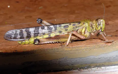
Desert locust
The desert locust is a large grasshopper of the deserts of Africa, the Middle East and Southwest Asia. Most of the time it lives alone. But after good rains, when locusts become crowded, they change their color and behavior and can gather into enormous swarms that fly long distances and eat farmers' crops.
-
 Watch
Animal
Sand cat
The sand cat is a small wild cat of the deserts of North Africa, Arabia and Central Asia. Its sandy coat hides it on the dunes, its big ears hear prey moving under the sand, and thick fur on the soles of its feet protects it from scorching days and freezing nights.
Explore next
-
Watch
Natural wonder
Sahara
The Sahara fills almost all of northern Africa. Britannica calls it the largest hot desert in the world: about 4,800 kilometers from east to west and about 8.6 million square kilometers in all. Only about a quarter of it is sand dunes; the rest is gravel plains, rocky plateaus and mountains.
-
Watch
Animal
Fennec fox
The fennec fox is the smallest member of the dog family. It lives in the Sahara and other deserts of North Africa, sleeps in cool burrows by day, and uses its enormous ears to hear insects moving under the sand at night.
-
Watch
Animal
Desert locust
The desert locust is a large grasshopper of the deserts of Africa, the Middle East and Southwest Asia. Most of the time it lives alone. But after good rains, when locusts become crowded, they change their color and behavior and can gather into enormous swarms that fly long distances and eat farmers' crops.
- Watch Geography What makes a desert? A desert is any place that gets very little rain or snow, usually less than about 250 millimeters a year. Deserts can be hot, like the Sahara, or freezing cold, like Antarctica, the driest continent. They form where winds, mountains or cold ocean currents keep rain away.
-
Watch
Animal
Sand cat
The sand cat is a small wild cat of the deserts of North Africa, Arabia and Central Asia. Its sandy coat hides it on the dunes, its big ears hear prey moving under the sand, and thick fur on the soles of its feet protects it from scorching days and freezing nights.
-
 Watch
 Country
Democratic Republic of the Congo
The Democratic Republic of the Congo, or DR Congo, is the second-largest country in Africa. The mighty Congo River curves through its rainforests, volcanoes rise in the east, and its capital, Kinshasa, is a center of music, fashion and popular culture.
-
 Watch
 Country
Ethiopia
Ethiopia is a country on the Horn of Africa with no coast. Much of it is high, rugged land cut by the Great Rift Valley, it is one of the world's oldest countries, and more than 110 million people live there.
-
 Watch
 Country
Kenya
Kenya is a country in East Africa, crossed by the equator. It has the snow-capped Mount Kenya, the deep Great Rift Valley, Lake Victoria and a long Indian Ocean coast, and about 54 million people live there, many of them speaking Swahili.
For parents & teachers
What children will learn
- Locate Algeria and describe its two main regions, the Tell and the Sahara.
- Explain why most people in Algeria live near the coast.
- Name some of Algeria's heritage sites, from Tassili rock art to Roman Timgad and the Kasbah of Algiers.
- Describe the Arabic and Amazigh languages and some foods of Algeria without treating the country as one single culture.
Recommended ages: 3 to 17 · About 15 minutes
Talk about it
- Why do you think so few people live in the Sahara, and where do they find water?
- How might a fennec's big ears and night-time habits help it in the desert?
- Why might two languages both be official in one country?
Try at home or in class
- On a map of Africa, shade the part of Algeria that is Sahara and the part that is the Tell, and compare their sizes.
- Use a ruler and squared paper to draw a town laid out like Timgad, with two main streets crossing in the middle.
Key vocabulary: Tell, erg, oasis, sirocco, Amazigh, independence, World Heritage Site
Where these facts come from
- Wikidata , Wikimedia Foundation (CC0 1.0)
- Natural Earth vector data , Natural Earth (NACIS) (Public domain)
- UNESCO World Heritage List , UNESCO World Heritage Centre (Linked as a reference; site facts come from Wikidata)
- Algeria (introduction and Land) , Encyclopaedia Britannica
- Algeria: Drainage, soils, climate, plant and animal life, ethnic groups , Encyclopaedia Britannica
- Algeria: Languages, religion, settlement and demographic trends , Encyclopaedia Britannica
- Algeria: Cultural life , Encyclopaedia Britannica
- Algeria: Colonial rule , Encyclopaedia Britannica
- Algérie - Tamanrasset et le massif du Hoggar : un des grands massifs montagneux du Sahara , CNES (French space agency)
- Algeria: The Algerian War of Independence , Encyclopaedia Britannica
- Algeria: Independent Algeria , Encyclopaedia Britannica
- Algiers , Encyclopaedia Britannica
- Oran , Encyclopaedia Britannica
- Constantine , Encyclopaedia Britannica
- Ahaggar , Encyclopaedia Britannica
- Western Sahara , Encyclopaedia Britannica
- Fennec , Encyclopaedia Britannica
- Population, total: Algeria , World Bank
- Timgad , UNESCO World Heritage Centre
- Djémila , UNESCO World Heritage Centre
- Al Qal'a of Beni Hammad , UNESCO World Heritage Centre
- Tassili n'Ajjer , UNESCO World Heritage Centre
- M'Zab Valley , UNESCO World Heritage Centre
- Kasbah of Algiers , UNESCO World Heritage Centre
- PlayOwl region table, version 1 , PlayOwl (PlayOwl original data)
- flag-icons 7.5.0 , Panayiotis Lipiridis and contributors (MIT)
- Wikimedia Commons , Wikimedia Foundation (Per file (public domain, CC0, CC BY or CC BY-SA); see each media record)
Checked, not yet human-reviewed. Last updated October 24, 2026. Spotted a mistake? Tell us.
Picture credits
- Photo: Xiaotong Gao, CC BY-SA 3.0, via Wikimedia Commons · source · license
- Photo: LBM1948, CC BY-SA 4.0, via Wikimedia Commons · source · license
- Photo: Maghnia-algeria, CC BY-SA 4.0, via Wikimedia Commons · source · license
- Photo: Fayeqalnatour, CC BY-SA 4.0, via Wikimedia Commons · source · license
- Photo: Benba.d.mourad, CC BY-SA 4.0, via Wikimedia Commons · source · license
- Photo: Alioueche Mokhtar, CC BY-SA 4.0, via Wikimedia Commons · source · license
- Photo: R hakka, CC BY-SA 4.0, via Wikimedia Commons · source · license