
 Country
Africa
Democratic Republic of the Congo
The Democratic Republic of the Congo is a big country in the middle of Africa. A huge river and thick rainforest cover much of it.
The Democratic Republic of the Congo, or DR Congo, is the second-largest country in Africa. The mighty Congo River curves through its rainforests, volcanoes rise in the east, and its capital, Kinshasa, is a center of music, fashion and popular culture.
The Democratic Republic of the Congo occupies most of the Congo River basin in Central Africa. It is Africa's second-largest country, with only a 40 km Atlantic coastline, equatorial rainforest at its heart and the Western Rift Valley, with its lakes and volcanoes, on its eastern border; the World Bank estimated its population at 112.8 million in 2025.
Photo: Ad Meskens, CC BY-SA 3.0, via Wikimedia Commons
Discover DR Congo
DR Congo is a very big country in Africa.
The Equator runs across it. A huge river called the Congo flows through it. Thick rainforest covers much of the land. The capital city is Kinshasa.
The Democratic Republic of the Congo sits in the middle of Africa, and the Equator runs across it. It is the second-largest country in Africa; only Algeria is bigger. People often call it DR Congo or the DRC, so it is not mixed up with its neighbor, the Republic of the Congo.
Most of the country is a huge, low basin drained by the Congo River, and thick rainforest covers its heart. Its capital, Kinshasa, stands on the Congo River. Its name comes from the river, which Europeans long ago linked with the kingdom of the Kongo people near its mouth.
The Democratic Republic of the Congo (DRC) is the second-largest country in Africa after Algeria, about 2,345,000 square kilometers. Apart from a coastline of about 40 km on the Atlantic it is landlocked. Britannica describes most of it as the central Congo basin, a vast rolling plain averaging about 520 m above sea level, bordered on almost every other side by high plateaus, with mountains along the Western Rift Valley in the east.
The name refers to the Congo River, which drains a basin lying mostly within the country; Europeans of the colonial period linked the river with the kingdom of the Kongo people near its mouth. From 1971 to 1997 the country was officially called Zaire, a variation of a local term meaning "great river." The World Bank estimated the population at 112,832,473 in 2025.
Cities and famous places
Kinshasa is the capital and the biggest city.
It stands beside the Congo River. It is a big center of music. Lubumbashi is a big city in the southeast. Some parks in DR Congo protect rainforests and volcanoes.
Kinshasa, the capital, stands on the Congo River about 515 kilometers from the sea. It is the largest city in central Africa and a center of music, fashion and popular culture. Until 1966 it was called Léopoldville. It grew from about 5,000 people in 1889 to about 4.7 million in the mid-1990s.
Lubumbashi in the southeast is the capital of the copper-mining region, and Mbuji-Mayi is the country's diamond center. Kisangani is as far up the river as boats can travel from Kinshasa. Parks such as Virunga, Salonga and the Okapi Wildlife Reserve are World Heritage Sites.
Kinshasa, on the Congo River about 515 km from its mouth, is the largest city in central Africa and the country's administrative, economic and cultural center. Britannica traces its growth from 5,000 people in 1889 to 250,000 in 1950, 1.5 million in 1971 and about 4.7 million in the mid-1990s, an increase of nearly a thousandfold in little more than a century; Wikidata gives about 14.6 million for 2020. It was called Léopoldville until 1966.
Lubumbashi (formerly Élisabethville) is the industrial capital of the copper-mining zone, Mbuji-Mayi the diamond center, Kisangani the terminal point of navigation upriver from Kinshasa, and Matadi the main port. UNESCO lists several national parks as World Heritage: Virunga (1979; on its List of World Heritage in Danger since 1994), Salonga (1984), the largest protected area of dense rainforest in Africa when both of its sectors are counted, and the Okapi Wildlife Reserve (1996; in danger since 1997).

Rainforest, river and volcanoes
The middle of DR Congo is warm and rainy.
Tall trees grow close together there. The Congo River is the second-longest river in Africa. In the east there are mountains and volcanoes. One volcano has a lake of hot, glowing lava.
Most of DR Congo has an equatorial climate: hot, humid and rainy all year. In the rainforest at the heart of the Congo basin, trees grow 40 to 50 meters tall. The Congo River, 4,700 kilometers long, is Africa's second-longest river after the Nile. It flows in a giant arc, crossing the Equator twice before it reaches the Atlantic Ocean.
In the east, a long valley holds a chain of big lakes, including Lake Kivu and Lake Tanganyika. The snowy Rwenzori Range on the border with Uganda reaches 5,109 meters at Margherita Peak. Farther south rise the Virunga volcanoes. The crater of one of them, Nyiragongo, holds a lake of lava.
Most of the country lies in the equatorial climatic zone within five degrees of the Equator, where average monthly temperatures rarely fall below the low to mid-20s °C and rain falls throughout the year (about 1,800 mm a year at Eala). The rainforest of the central basin has trees 40 to 50 m tall; mangroves dominate the coastal swamps and the river's mouth, and mountain forest, bamboo and Afro-alpine plants grow on the highest peaks. The Congo, Africa's second-longest river at 4,700 km, drains a basin of about 3,460,000 km²; Britannica's river article traces it to the highlands of northeastern Zambia, where it rises as the Chambeshi, and it crosses the Equator twice before emptying into the Atlantic below Matadi.
The Western Rift Valley, the western arm of the East African Rift System, forms the eastern border and holds Lakes Albert, Edward, Kivu, Tanganyika and Mweru. Margherita Peak in the Rwenzori Range (5,109 m) is the highest point. UNESCO notes that Nyiragongo and nearby Nyamuragira are Africa's two most active volcanoes, together responsible for two-fifths of the continent's historic eruptions, and that Nyiragongo's crater holds an almost permanent lava lake.

Animals of DR Congo
The okapi has stripes on its legs.
It is a close cousin of the giraffe. Bonobos and chimpanzees live in the forests. Gorillas live in the mountains in the east. Hippos live in the rivers and lakes.
The okapi has white-and-black striped legs, but it is not a zebra: it is the only close living relative of the giraffe, with big ears and a long, dark tongue for stripping leaves. Wild okapis live only in DR Congo, in the northern forests.
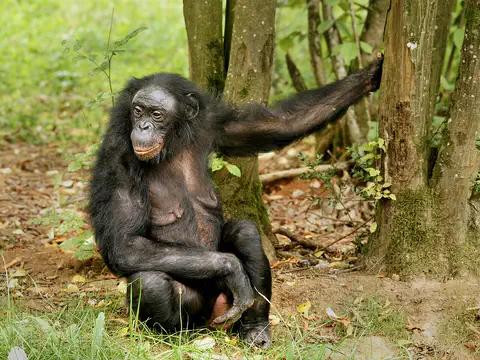
Great apes live here too. Chimpanzees live mostly in the equatorial forest, gorillas in the eastern mountains around Lake Kivu, and bonobos only in the lowland rainforests south of the Congo River. Forest elephants, hippopotamuses and crocodiles live here too, along with hundreds of kinds of butterflies.
Britannica describes rich, diverse wildlife: chimpanzees mostly in the equatorial forest, gorillas in the eastern mountains around Lake Kivu, bonobos only in lowland rainforest along the south bank of the Congo River, and African forest elephants, a smaller, distinct species, limited to the forest. The okapi (Okapia johnstoni), endemic to the country and the giraffe's only close living relative, lives in the primary forests of Uele, Aruwimi and Ituri.
UNESCO's descriptions give a sense of scale. The Okapi Wildlife Reserve protects one-fifth of the Ituri forest, an estimated 5,000 okapis (one-sixth of all okapis) and 17 primate species. Virunga National Park ranges from 680 m to 5,109 m, has recorded 218 mammal and 706 bird species, shelters about a third of the world's mountain gorillas and has Africa's largest concentration of hippopotamuses, along Lake Edward and nearby rivers. Britannica notes that animal life has diminished in spite of efforts to limit hunting.
People, languages and music
Many different groups of people live in DR Congo.
They speak more than 200 languages. French is used in schools and offices. Lingala, Swahili, Kongo and Tshiluba are spoken widely too. Congolese rumba is a kind of music and dance.
More than 200 ethnic groups live in DR Congo, and most belong to the large family of Bantu peoples. People speak more than 200 languages. French is the official language, used in schools, business and government, and four national languages, Swahili, Tshiluba, Lingala and Kongo, help people from different groups talk to each other. Lingala is widely spoken in Kinshasa and in its popular music.
Kinshasa is a center of music, fashion and popular culture. Congolese rumba, usually danced by a couple, was added to UNESCO's heritage lists in 2021. Traditional crafts include pottery, raffia weaving and carving.
More than 200 ethnic groups live in the country; Bantu peoples, who entered the region between the 10th and 14th centuries, form a large majority, with major cultural clusters such as the Mongo, Kongo, Luba, Lunda and Bemba. Forest peoples such as the Mbuti and Twa are thought to have been the earliest inhabitants of the Congo basin. About half the population is rural, and Britannica notes that more than two-fifths are younger than 15.
French is the official language of instruction and administration; Swahili, Tshiluba, Lingala and Kongo are national languages used in regional trade and on the radio. Britannica describes a very sizable Christian population, the largest share Roman Catholic; others follow traditional African beliefs or Islam. In 1950s Kinshasa, musicians forged a style called African jazz, and rumba and soukous became popular in the 1960s; Congolese music's influence is felt especially throughout sub-Saharan Africa. UNESCO inscribed Congolese rumba, shared with the Republic of the Congo, in 2021; its roots lie in an old dance called nkumba ("waist" in Kikongo). In the visual arts, the Kuba are known for ndop statues made in the likeness of their kings, and Luba art for statuettes depicting motherhood.

A long history
People have lived here for a very, very long time.
Long ago, there were kingdoms near the big river. Later, Belgium ruled the land. In 1960 the country became free to rule itself.
Bantu peoples arrived between the 900s and the 1300s. From the 1400s to the 1600s the Kongo kingdom in the west and the Luba and Lunda states in the east grew powerful.
In 1885, King Leopold II of Belgium took the Congo basin as his own personal colony, called the Congo Free State. In 1908 it became a colony of Belgium, the Belgian Congo. The country became independent on June 30, 1960. From 1971 to 1997 it was called Zaire, and then it took back the name Democratic Republic of the Congo.
Bantu peoples entered the region between the 10th and 14th centuries. From the 15th to the 17th century several state systems developed in the southern savanna, chief among them the Kongo kingdom in the west and the Luba-Lunda states in the east, while village communities remained the rule in the rainforest. In the 16th century the Atlantic slave trade created powerful interests among Kongo's provincial chiefs that undermined the kingdom.
After Henry Morton Stanley's journey down the Congo in 1874–77, King Leopold II of the Belgians had the basin recognized at the Berlin Conference (1884–85) as his personal Congo Free State (1885–1908), which Britannica associates with forced labor and atrocities against Congolese people. After international criticism the Belgian Parliament annexed it in 1908 as the Belgian Congo. Independence came on June 30, 1960. Mobutu Sese Seko renamed the country Zaire in 1971; after his overthrow in 1997 the name Democratic Republic of the Congo returned. Britannica records that the country was then plunged into a devastating civil war that officially ended in 2003, although fighting continued in the east.
DR Congo on the map
Find DR Congo in the middle of Africa.
The Equator crosses it. It has only a very short coast on the ocean. Nine countries are its neighbors.
DR Congo is in Central Africa, and the Equator runs across it. It has nine neighbors: the Central African Republic and South Sudan to the north; Uganda, Rwanda, Burundi and Tanzania to the east; Zambia to the southeast; and Angola to the southwest.
In the west, the country reaches the Atlantic Ocean, but its coastline is only about 40 kilometers long. To the west lies the Republic of the Congo; its capital, Brazzaville, faces Kinshasa across a wide part of the Congo River called Malebo Pool.
Britannica gives the boundaries: the Central African Republic and South Sudan to the north; Uganda, Rwanda, Burundi and Tanzania to the east; Zambia to the southeast; Angola to the southwest; and to the west the short Atlantic coastline, Angola's exclave of Cabinda and the Republic of the Congo (Congo-Brazzaville). The Western Rift Valley, with Lakes Albert, Edward, Kivu, Tanganyika and Mweru, forms the eastern border, and Kinshasa and Brazzaville face each other across Malebo Pool, a lakelike widening of the lower Congo.
Most of the country lies within five degrees of the Equator. Lake Mai-Ndombe, at 338 m, is the lowest point of the central basin, which Britannica suggests may once have been an inland sea. Its 40 km of coast make it almost, but not quite, landlocked.
- Area
- about 2,345,000 km²
- Atlantic coastline
- about 40 km
- Highest point
- Margherita Peak, 5,109 m
- Neighboring countries
- 9
Amazing facts
-
The Congo River crosses the Equator two times.
The Congo River flows north and then south in a great arc, so it crosses the Equator twice.
The Congo flows north and then south in a great arc through the country, crossing the Equator twice before reaching the Atlantic below Matadi.
-
One volcano here has a lake of lava inside it.
The crater of Mount Nyiragongo holds a lake of lava that is almost always there.
UNESCO describes Nyiragongo's crater as filled by an almost permanent lava lake, and Nyiragongo and Nyamuragira as responsible for two-fifths of Africa's historic eruptions.
-
The okapi has stripes like a zebra, but it is a giraffe's cousin.
Okapis have striped legs like zebras, but their closest living relative is the giraffe.
The okapi (Okapia johnstoni) belongs to the giraffe family, Giraffidae, and is the giraffe's only close living relative.
-
Kinshasa was once a small town. Now it is a giant city.
Kinshasa had about 5,000 people in 1889 and about 4.7 million by the mid-1990s.
Britannica describes Kinshasa growing nearly a thousandfold in little more than a century, from 5,000 people in 1889 to about 4.7 million in the mid-1990s.
-
Bonobos live only on one side of the Congo River.
Bonobos are found only in the lowland rainforests south of the Congo River.
Bonobos (Pan paniscus) are found only in lowland rainforest along the south bank of the Congo River.
Words to know
- basin
- all the land drained by a river and the streams that flow into it
- Equator
- the imaginary line around the middle of Earth, halfway between the North and South Poles
- rainforest
- a thick forest of tall trees in a place where it rains a lot all year
- rift valley
- a long valley that forms where Earth's crust is being pulled apart
- lava lake
- a pool of melted rock that stays inside a volcano's crater
- endemic
- living naturally in only one place in the world
- national language
- a language a country officially recognizes as one of its own, used widely by its people
Discovery challenge
-
What is the capital city of DR Congo?
Which city is the capital of the Democratic Republic of the Congo?
Which city, about 515 km up the Congo River from its mouth, is the country's capital?
- Kinshasa
- Lubumbashi
- Nairobi
Show the answer
Kinshasa
Kinshasa is the capital. It is beside the Congo River.
Kinshasa, on the Congo River, is the capital and the largest city in central Africa.
Kinshasa, called Léopoldville until 1966, is the capital; Lubumbashi is the copper-mining capital of the southeast, and Nairobi is the capital of Kenya.
-
Which big river flows through DR Congo?
Which river crosses the Equator twice as it flows through the country?
Which river, with a basin of about 3,460,000 km², crosses the Equator twice?
- The Nile
- The Congo
- The Amazon
Show the answer
The Congo
The Congo River flows through the country. The country is named after it.
The Congo River flows north and then south in a great arc, crossing the Equator twice.
The Congo, Africa's second-longest river, drains about 3.46 million km² and crosses the Equator twice before entering the Atlantic below Matadi.
-
The okapi has stripy legs. Which animal is its close cousin?
Which animal is the okapi's only close living relative?
The okapi belongs to the family Giraffidae. Which animal is its only close living relative?
- Zebra
- Horse
- Giraffe
Show the answer
Giraffe
The okapi is a cousin of the giraffe, even with zebra stripes.
Okapis have striped legs, but their big ears, long dark tongue and, in males, bony head bumps are like a giraffe's.
Despite its zebra-like leg stripes, the okapi is a giraffid; like giraffes, males have ossicones and it has a long, prehensile tongue.
-
Which volcano has a lake of hot lava inside?
Which volcano in Virunga National Park has a lava lake in its crater?
Which Virunga volcano's crater holds an almost permanent lava lake?
- Nyiragongo
- Mount Fuji
- Mount Etna
Show the answer
Nyiragongo
Nyiragongo has a lake of glowing lava inside it.
Nyiragongo, in Virunga National Park, has a lava lake in its crater.
UNESCO describes Nyiragongo's crater as filled by an almost permanent lava lake; it and Nyamuragira are Africa's two most active volcanoes.
-
How many languages do people speak in DR Congo?
About how many languages are spoken in DR Congo?
Alongside French and four national languages, how many languages are spoken in the country?
- Just one
- About 10
- More than 200
Show the answer
More than 200
People speak more than 200 languages!
More than 200 languages are spoken. French and four national languages help people from different groups talk together.
More than 200 languages are spoken; French is official, and Swahili, Tshiluba, Lingala and Kongo are national languages.
Places to discover in Democratic Republic of the Congo
-
 Watch
Natural wonder
River Congo
The Congo is Africa's second-longest river, about 4,700 kilometers long. It curves in a giant arc through the rainforests of central Africa and empties into the Atlantic Ocean. Rain falls in its basin all year, so it carries a huge amount of water, and its wild lower rapids are home to about 320 kinds of fish, about 90 of them found nowhere else.
-
 Watch
Natural wonder
Lake Tanganyika
Lake Tanganyika lies in a deep crack in Africa called a rift valley. Britannica calls it the longest freshwater lake in the world, and only Lake Baikal, in Russia, is deeper. Four countries share it: Tanzania, the Democratic Republic of the Congo, Burundi and Zambia. Its water is home to about 250 kinds of cichlid fish found nowhere else.
-
 Watch
Natural wonder
Great Rift Valley
The Great Rift Valley is a huge valley that runs through East Africa, where the continent is slowly being stretched and pulled apart. Long, steep cliffs line its sides, its floor holds lakes full of flamingos, and giant volcanoes such as Kilimanjaro and Mount Kenya rose beside it. Scientists think a new ocean may one day open here.
-
Watch
Natural wonder
Virunga National Park
Virunga National Park, in the east of the Democratic Republic of the Congo, was founded in 1925; the park describes itself as Africa's first national park. It stretches from active volcanoes in the south to the snowy Rwenzori Mountains in the north. About one third of the world's mountain gorillas live in its forests, along with elephants, hippos, chimpanzees and hundreds of kinds of birds.
-
Watch
Natural wonder
Mount Nyiragongo
Mount Nyiragongo is a steep volcano in the Virunga Mountains of the Democratic Republic of the Congo, near the border with Rwanda and just north of Lake Kivu. It is 3,470 meters high, and its deep summit crater often holds a lake of bubbling lava. Its lava is very runny, and eruptions in 1977, 2002 and 2021 sent lava flowing down its sides toward the city of Goma.
Animals of Democratic Republic of the Congo
-
 Watch
Animal
Okapi
The okapi has a velvety reddish-brown coat and zebra-like stripes on its legs, but its closest living relative is the giraffe. It lives only in the rainforests of the Democratic Republic of the Congo, where it browses leaves with a long, dark tongue. It is endangered.
-
 Watch
Animal
Bonobo
The bonobo is a great ape that looks a lot like a chimpanzee but is more slender, with a rounder head. It lives only in the rainforests south of the Congo River, in groups where females take the lead and squabbles rarely turn into fights.
-
 Watch
Animal
Eastern gorilla
The eastern gorilla is the gorilla of the misty mountains and forests of east-central Africa. It has two kinds: the shaggy mountain gorilla, whose numbers are slowly growing, and the big Grauer's gorilla, which has become much rarer.
-
 Watch
Animal
Goliath beetle
The Goliath beetle is one of the largest beetles on Earth, from about 5 to 11 centimeters long. It lives in the rainforests of central and eastern Africa, where the adults drink tree sap. Its huge grubs need protein-rich food to grow, and they may even hunt other small animals.
Explore next
-
Watch
Natural wonder
Virunga National Park
Virunga National Park, in the east of the Democratic Republic of the Congo, was founded in 1925; the park describes itself as Africa's first national park. It stretches from active volcanoes in the south to the snowy Rwenzori Mountains in the north. About one third of the world's mountain gorillas live in its forests, along with elephants, hippos, chimpanzees and hundreds of kinds of birds.
-
Watch
Natural wonder
River Congo
The Congo is Africa's second-longest river, about 4,700 kilometers long. It curves in a giant arc through the rainforests of central Africa and empties into the Atlantic Ocean. Rain falls in its basin all year, so it carries a huge amount of water, and its wild lower rapids are home to about 320 kinds of fish, about 90 of them found nowhere else.
-
Watch
Natural wonder
Mount Nyiragongo
Mount Nyiragongo is a steep volcano in the Virunga Mountains of the Democratic Republic of the Congo, near the border with Rwanda and just north of Lake Kivu. It is 3,470 meters high, and its deep summit crater often holds a lake of bubbling lava. Its lava is very runny, and eruptions in 1977, 2002 and 2021 sent lava flowing down its sides toward the city of Goma.
-
Watch
Animal
Okapi
The okapi has a velvety reddish-brown coat and zebra-like stripes on its legs, but its closest living relative is the giraffe. It lives only in the rainforests of the Democratic Republic of the Congo, where it browses leaves with a long, dark tongue. It is endangered.
-
Watch
Animal
Bonobo
The bonobo is a great ape that looks a lot like a chimpanzee but is more slender, with a rounder head. It lives only in the rainforests south of the Congo River, in groups where females take the lead and squabbles rarely turn into fights.
-
Watch
Animal
Eastern gorilla
The eastern gorilla is the gorilla of the misty mountains and forests of east-central Africa. It has two kinds: the shaggy mountain gorilla, whose numbers are slowly growing, and the big Grauer's gorilla, which has become much rarer.
- Watch Geography The equator The Equator is an imaginary line around Earth's middle, halfway between the North and South Poles, at 0 degrees latitude. It splits Earth into the Northern and Southern Hemispheres. It is about 40,075 kilometers long and crosses countries such as Ecuador, Kenya, Gabon and Indonesia.
-
Watch
Natural wonder
Lake Tanganyika
Lake Tanganyika lies in a deep crack in Africa called a rift valley. Britannica calls it the longest freshwater lake in the world, and only Lake Baikal, in Russia, is deeper. Four countries share it: Tanzania, the Democratic Republic of the Congo, Burundi and Zambia. Its water is home to about 250 kinds of cichlid fish found nowhere else.
For parents & teachers
What children will learn
- Locate the Democratic Republic of the Congo, the Equator and the Congo River on a map.
- Describe the Congo basin rainforest, the Western Rift Valley lakes and the Virunga volcanoes.
- Name some of the country's wildlife, such as okapis, bonobos and gorillas, and where they live.
- Outline the country's history from the Kongo kingdom to independence in 1960.
Recommended ages: 3 to 17 · About 15 minutes
Talk about it
- Why might a river be so important to a country that it gives the country its name?
- How do you think people who speak different languages find ways to understand each other?
- Why do you think protecting large parks helps animals like okapis and gorillas?
Try at home or in class
- On a globe or world map, trace the Congo River's arc with a piece of string and count how many times it crosses the Equator.
- Listen to a recording of Congolese rumba together and clap along to the beat.
Key vocabulary: basin, Equator, rainforest, rift valley, lava lake, endemic, national language
Where these facts come from
- Wikidata , Wikimedia Foundation (CC0 1.0)
- Natural Earth vector data , Natural Earth (NACIS) (Public domain)
- UNESCO World Heritage List , UNESCO World Heritage Centre (Linked as a reference; site facts come from Wikidata)
- Democratic Republic of the Congo (introduction, Land, Relief, Drainage and soils, Climate) , Encyclopaedia Britannica
- Democratic Republic of the Congo: Plant and animal life , Encyclopaedia Britannica
- Democratic Republic of the Congo: People (ethnic groups, languages, religion) , Encyclopaedia Britannica
- Democratic Republic of the Congo: Settlement patterns and demographic trends , Encyclopaedia Britannica
- Democratic Republic of the Congo: The arts, sports and recreation , Encyclopaedia Britannica
- Democratic Republic of the Congo: History (precolonial perspectives, the Congo Free State) , Encyclopaedia Britannica
- Democratic Republic of the Congo: Belgian paternalism and the politics of decolonization , Encyclopaedia Britannica
- Congo River , Encyclopaedia Britannica
- Boyoma Falls , Encyclopaedia Britannica
- Virunga National Park , UNESCO World Heritage Centre
- Okapi Wildlife Reserve , UNESCO World Heritage Centre
- Salonga National Park , UNESCO World Heritage Centre
- Congolese rumba , UNESCO Intangible Cultural Heritage
- Okapi , San Diego Zoo Wildlife Alliance
- Population, total: Congo, Dem. Rep. , World Bank
- Population, Total for the Democratic Republic of the Congo (World Bank series POPTOTCDA647NWDB) , Federal Reserve Bank of St. Louis (FRED)
- PlayOwl region table, version 1 , PlayOwl (PlayOwl original data)
- flag-icons 7.5.0 , Panayiotis Lipiridis and contributors (MIT)
- Wikimedia Commons , Wikimedia Foundation (Per file (public domain, CC0, CC BY or CC BY-SA); see each media record)
Checked, not yet human-reviewed. Last updated October 24, 2026. Spotted a mistake? Tell us.
Picture credits
- Photo: Ad Meskens, CC BY-SA 3.0, via Wikimedia Commons · source · license
- Photo: Marc Vick, CC BY-SA 4.0, via Wikimedia Commons · source · license
- Photo: Cai Tjeenk Willink (Caitjeenk), CC BY-SA 3.0, via Wikimedia Commons · source · license
- Photo: Oasisk., CC BY 2.5, via Wikimedia Commons · source · license
- Photo: Ad Meskens, CC BY-SA 3.0, via Wikimedia Commons · source · license