
 Country
Asia
Armenia
Armenia is a small country high in the mountains. It has no sea coast, and its capital city is Yerevan.
Armenia is a small, landlocked country just south of the Caucasus mountains. Most of it is high mountains and plateaus, its tallest peak is Mount Aragats, and about 3.1 million people lived there in 2025.
Armenia is a landlocked, mountainous country of Transcaucasia with an average elevation of 1,800 m and no lowlands. Its Statistical Committee estimated 3,090,500 permanent residents on 1 October 2025, and the capital, Yerevan, stands near the site of the fortress of Erebuni, built in 783 BCE.
Photo: Սէրուժ Ուրիշեան (Serouj Ourishian), CC BY 4.0, via Wikimedia Commons
Discover Armenia
Armenia is a small country in the mountains.
It has no sea coast. Most of its land is high up. The capital city is called Yerevan.
Armenia is a small, landlocked country, which means it has no coast on any sea or ocean. It lies just south of the great Caucasus mountain range, at the northwestern edge of Asia. Its neighbors are Georgia, Azerbaijan, Iran and Turkey.
Armenia is a land of mountains, high plateaus and deep river valleys. On average the land is about 1,800 meters above sea level, and there are no lowlands at all. The capital is Yerevan. About 3.1 million people lived in Armenia in 2025, and nearly all of them speak Armenian.
Armenia is a landlocked country of Transcaucasia, lying just south of the great Caucasus range and facing the northwestern edge of Asia. Georgia and Azerbaijan border it to the north and east, Iran to the southeast and Turkey to the west, while Naxçıvan, an exclave of Azerbaijan, borders it to the southwest. It covers about 29,700 square kilometers.
Britannica describes the modern state as only a small part of ancient Armenia, which at its height reached from the south-central Black Sea coast to the Caspian Sea. The land is mountainous and geologically unstable: the average elevation is 1,800 m, half the territory lies between about 1,000 and 2,000 m, and only about one-tenth lies below 1,000 m. Armenia's Statistical Committee estimated the permanent population at 3,090,500 on 1 October 2025.
Cities and famous places
Yerevan is the capital city.
Many of its buildings are made of colored stone. A huge snowy mountain rises behind the city. Geghard is an old monastery cut into the rock.
Yerevan, the capital, sits on the Hrazdan River. It is very old: the fortress of Erebuni was built there in 783 BCE, and Yerevan has been the capital since 1920. Many of its buildings are made of local stone in different colors. To the south, across the border in Turkey, Mount Ararat rises behind the city.
About 1.14 million people lived in Yerevan in 2025. Gyumri is Armenia's second-largest city. East of Yerevan, at the entrance to the Azat Valley, the monastery of Geghard has churches and tombs carved right into the cliffs.
Yerevan stands on the Hrazdan River, 23 km from the Turkish border. It is first recorded in 607 CE, but archaeology traces a settlement on the site to the 6th–3rd millennia BCE and the fortress of Erebuni to 783 BCE. Romans, Parthians, Arabs, Mongols, Turks, Persians, Georgians and Russians all ruled it at times; it fell to the Russians in 1827 and became the capital of the independent Armenian republic in 1920. Its university dates from 1919, and the Matenadaran archives (founded 1920) hold ancient Armenian manuscripts such as the Lazarus Gospel of 887. Preliminary figures from the Statistical Committee put its population at 1,144,700 in 2025.
The Monastery of Geghard and the Upper Azat Valley, a World Heritage Site since 2000, has monuments from the 4th to the 13th century. Most of its churches and tombs are cut into the living rock; the first rock-cut church was built before 1250 and the second in 1283. It also held a school, a scriptorium and a library, and UNESCO calls it an exceptionally complete example of medieval Armenian monastic architecture.

Mountains, lakes and weather
Armenia has many tall mountains.
The tallest is Mount Aragats. It is an old volcano that does not erupt now. Lake Sevan is a big lake high up in the mountains. Summers are hot and sunny.
The highest peak, Mount Aragats, is 4,090 meters tall. It is an extinct volcano, and its old crater now holds a glacier. The northwest, where Aragats stands, has high ranges, deep river valleys and lava plateaus dotted with other extinct volcanoes.
In the east, Lake Sevan lies about 1,900 meters above sea level and covers 1,360 square kilometers. Armenia's rivers are short and fast, with many rapids and waterfalls. On the plains, summers are long and hot, about 25 °C on average, while winters are usually not very cold, about −5 °C in January. Armenia also has strong earthquakes.
Mount Aragats (4,090 m), the highest point of both Armenia and the Lesser Caucasus, is a circular, shieldlike mountain of lavas and tufas: a volcanic cone of recent geologic age sits on far older rocks, and its crater has become the cirque of a glacier. The ranges of the Lesser Caucasus cross the north, with volcanic plateaus cut by deep valleys between them. In the southwest, the Aras River divides the Ararat Plain, its northern half in Armenia and its southern half in Turkey and Iran.
Lake Sevan covers 1,360 km² at 1,905 m. It drains through the Hrazdan to the Aras, but loses most of its water to evaporation; hydroelectric plants on the Hrazdan lowered it, so a 49-km tunnel was built in the late 1970s to bring in water from the Arpa. The climate is dry and continental: plain temperatures average 25 °C in June and August and −5 °C in January, and the record low is −46 °C. Mountain slopes get about 800 mm of rain a year, sheltered plains only about 200 to 400 mm. On 7 December 1988 an earthquake destroyed the town of Spitak and badly damaged Gyumri; about 25,000 people were killed.

Plants and animals
Wild goats and wild sheep live high in the mountains.
Bears and lynx live in the forests. Big birds called bearded vultures live high up too. Leopards live in Armenia, but they are very rare.
Armenia is small, but it has more than 3,000 kinds of plants, more than the whole vast Russian Plain. Going up from the dry plains to the peaks, the land changes from semidesert to steppe grassland, then forest, alpine meadow and, at the very top, tundra.
Each zone has its own animals. Wild boar, jackals and wildcats live in the dry semidesert of the lower slopes and plains, where leopards are found only rarely. The forests of the northeast are mostly beech trees, home to the Syrian bear, lynx and squirrels. High in the mountains live the bezoar goat and the mouflon, a wild sheep, and bearded vultures are among the mountain birds.
Armenia's broken relief and its position where several biogeographic regions meet produce a great variety of landscapes. Though small, the country has more than 3,000 plant species, more than the vast Russian Plain, in five altitudinal zones: semidesert, steppe, forest, alpine meadow and high tundra. The semidesert, up to about 1,300–1,400 m, carries sagebrush and drought-resistant plants such as juniper, sloe, dog rose and honeysuckle; boar, wildcat, jackal, adder, the venomous gurza, scorpions and, more rarely, the leopard live there.
Steppe is the most widespread zone. Forest covers nearly one-tenth of the country: largely beech in the northeast and oak in the drier southeast, with hackberry, pistachio and dogwood lower down. Its animals include the Syrian bear, wildcat, lynx and squirrel, and woodcocks, robins, warblers, titmice and woodpeckers are numerous. Above about 2,000 m, alpine meadows give good summer pasture; the mountain turkey, horned lark and bearded vulture live there, and the mountains shelter the bezoar goat and the mouflon.
People, language and food
About three million people live in Armenia.
Most people speak Armenian. Armenian has its own alphabet. A thin bread called lavash is baked in clay ovens.
About 3.1 million people lived in Armenia in 2025, and about two-thirds of people live in towns and cities. Nearly everyone is Armenian and speaks Armenian, a language that forms its own branch of the big Indo-European family. Kurds, Russians and smaller groups, such as Ukrainians and Assyrians, live in Armenia too.
Armenian is written in its own alphabet, created in the 400s and still used today. Lavash is a traditional thin bread, slapped onto the wall of a clay oven to bake and often rolled around cheese, greens or meat. Grapes grow well on the sunny, watered Ararat Plain, and peaches and apricots are the most common orchard fruits.
Armenia's Statistical Committee estimated 3,090,500 permanent residents on 1 October 2025, about 1,144,700 of them in Yerevan (preliminary). Britannica notes that two-thirds of the population is urban, and that emigration waves in the 20th century mean that, by most estimates, at least 5 million Armenians live abroad, more than 1 million of them in the United States. Armenians make up nearly the whole population; Kurds, Russians and small numbers of Ukrainians, Assyrians and others make up the rest. Most believers belong to the Armenian Apostolic Church or the Armenian Catholic Church.
Armenian is a distinct branch of the Indo-European family. Its script of 38 letters (31 consonants and 7 vowels) dates from the 5th century; local tradition says Mesrop Mashtots invented it in 405, and it was probably modeled on the Pahlavi script with Greek influence. Lavash, inscribed by UNESCO in 2014, is usually made by a small group of women working together: thin sheets of wheat dough are stretched over an oval cushion and slapped onto the wall of a conical clay oven, while men make the cushions and build the ovens. Vineyards are the leading branch of farming, and peaches and apricots are the most common orchard crops.
A long history
People have lived in Armenia for a very long time.
Long ago, a fortress was built where Yerevan is now. Armenians made their own alphabet about 1,600 years ago. In 1991, Armenia became an independent country.
Ancient Armenia was one of the world's oldest centers of civilization. Where Yerevan stands now, the fortress of Erebuni was built in 783 BCE. In the 1st century BCE, under King Tigranes the Great, Armenia was for a short time the strongest state in the eastern Roman world. In the early 300s King Tiridates III made Christianity the state religion, and in the 400s the Armenian alphabet was created.
Later, Armenia lost its self-rule. For centuries it was ruled by the Ottoman and Persian empires, and in the 1800s eastern Armenia became part of the Russian Empire. Armenia declared independence in 1918, became a Soviet republic in 1920, and became an independent country again in 1991.
Armenians first appear in history shortly after the end of the 7th century BCE; the region was absorbed into the Median and then the Achaemenian Persian empires (c. 550 BCE). After Rome defeated the Seleucid king Antiochus III in 190–189 BCE, Artaxias founded an independent kingdom with its capital, Artashat, near modern Yerevan, and Tigranes II (95–55 BCE) briefly made Armenia the strongest state of the Roman east. The conversion of Tiridates III and the adoption of Christianity as the state religion (c. 314) shaped much of what followed, and the 5th century, which produced the alphabet and a national literature, was a cultural golden age.
Armenia lost its autonomy in the 14th century and lived for centuries under Ottoman and Persian rule; Russia annexed eastern Armenia in the 19th century. In 1894–96 and 1915 the Ottoman government carried out systematic massacres and forced deportations of Armenians; the deportations and mass killings of 1915–16 are known as the Armenian Genocide. Armenia declared independence on 28 May 1918; after invasion by Turkish and Soviet Russian forces, the Soviet Republic of Armenia was set up on 29 November 1920 and became a Soviet union republic in 1936. It declared sovereignty on 23 August 1990 and independence on 23 September 1991. From 1988 the status of Nagorno-Karabakh, an enclave in southwestern Azerbaijan populated mainly by ethnic Armenians, was the source of conflict between Armenia and Azerbaijan. By the mid-1990s Karabakh Armenian forces held much of southwestern Azerbaijan; after a war in 2020 they had to withdraw from most of that area, and in 2023 Azerbaijan took control of the region, from which more than 100,000 of its roughly 120,000 ethnic Armenians fled.
Armenia on the map
Find Armenia on the globe.
It is south of a long line of big mountains called the Caucasus. It has no sea coast. Four countries are its neighbors.
Armenia is in a region called Transcaucasia, just south of the Caucasus mountains. It has no coastline. Georgia lies to the north, Azerbaijan to the east, Iran to the southeast and Turkey to the west. A separate piece of Azerbaijan, called Naxçıvan, touches Armenia's southwest.
For about 480 kilometers, the Aras River forms a natural border between Armenia and its neighbors Turkey and Iran. Most of Armenia's rivers drain into the Aras, which joins the Kura River on its way to the Caspian Sea.
Armenia lies in Transcaucasia, on the northwestern edge of Asia, south of the Caucasus. It is bounded by Georgia and Azerbaijan to the north and east, Iran to the southeast and Turkey to the west; Naxçıvan, an exclave of Azerbaijan (a piece of a country separated from the rest of it), borders it to the southwest.
Most Armenian rivers belong to the basin of the Aras, a tributary of the Kura in the Caspian Basin, which forms a natural boundary with Turkey and Iran for about 480 km. The Aras splits the Ararat Plain between Armenia to the north and Turkey and Iran to the south. Lake Sevan is fed by dozens of rivers, but only the Hrazdan flows out of it.
- Neighbors
- Georgia, Azerbaijan, Iran and Turkey
- Coastline
- none (landlocked)
- Average elevation
- 1,800 m
- Aras River border
- about 480 km, with Turkey and Iran
Amazing facts
-
Armenia has no low land at all.
Armenia has no lowlands: on average its land is 1,800 meters above sea level.
Armenia's average elevation is 1,800 m; half the territory lies between about 1,000 and 2,000 m, and only about one-tenth lies below 1,000 m.
-
Armenia has more kinds of plants than a much bigger land.
Small Armenia has more than 3,000 kinds of plants, more than the huge Russian Plain.
Britannica notes that Armenia has more than 3,000 plant species, more than the vast Russian Plain, spread over five altitudinal zones.
-
Lavash bread bakes in about one minute.
Lavash bakes on the hot wall of a clay oven in thirty seconds to a minute, and it can keep for up to six months.
UNESCO describes lavash as baked against the wall of a conical clay oven for thirty seconds to a minute; it can be stored for up to six months.
-
The Armenian alphabet has 38 letters.
The Armenian alphabet has 38 letters, 31 consonants and 7 vowels, and it has been used since the 400s.
The Armenian script of 38 letters (31 consonants, 7 vowels) was developed in the 5th century; it writes from left to right and has letters for vowels, which shows Greek influence.
-
Mount Aragats has a glacier in its old crater.
The crater of Mount Aragats, an extinct volcano, has become the bowl of a glacier.
Aragats's crater has become the steep-walled basin, or cirque, of a glacier, and several smaller glaciers lie on the mountain.
Words to know
- landlocked
- having no coast on any sea or ocean
- plateau
- a large area of high, fairly flat land
- extinct volcano
- a volcano that is not expected to erupt again
- exclave
- a piece of a country that is separated from the rest of it
- alphabet
- a set of letters used to write a language
- monastery
- a group of buildings where monks live, work and worship
- World Heritage Site
- a place UNESCO lists as important to all people, to be protected
Discovery challenge
-
What is the capital city of Armenia?
Which city is the capital of Armenia?
Which city, near the site of the fortress of Erebuni (783 BCE), is Armenia's capital?
- Yerevan
- Gyumri
- Tbilisi
Show the answer
Yerevan
Yerevan is the capital of Armenia.
Yerevan has been Armenia's capital since 1920. Gyumri is its second-largest city, and Tbilisi is the capital of Georgia.
Yerevan, on the Hrazdan River, became the capital of the independent Armenian republic in 1920 and stayed the capital through Soviet rule and renewed independence.
-
Armenia has no sea coast. What word means that?
Armenia has no coast on any sea or ocean. What do we call a country like that?
Which term describes Armenia, a country with no coastline?
- Landlocked
- An island
- A peninsula
Show the answer
Landlocked
Landlocked means land all around and no sea.
A landlocked country has no coastline. Armenia is surrounded by Georgia, Azerbaijan, Iran and Turkey.
Armenia is a landlocked country of Transcaucasia; its neighbors are Georgia, Azerbaijan, Iran and Turkey, plus Azerbaijan's exclave of Naxçıvan.
-
What is the tallest mountain in Armenia?
Which mountain is the highest in Armenia?
Which shieldlike volcano, 4,090 m high, is Armenia's highest point?
- Mount Everest
- Mount Aragats
- Mount Fuji
Show the answer
Mount Aragats
Mount Aragats is the tallest. It is an old volcano.
Mount Aragats, 4,090 meters tall, is Armenia's highest peak. Mount Ararat, which can be seen from Yerevan, is across the border in Turkey.
Aragats is the highest point of both Armenia and the Lesser Caucasus; it is built of lavas and tufas, and its crater holds a glacier.
-
What is lavash?
What is lavash, a traditional food in Armenia?
Lavash, added to UNESCO's heritage lists in 2014, is what?
- A thin bread
- A kind of fish
- A mountain lake
Show the answer
A thin bread
Lavash is a thin bread baked in a clay oven.
Lavash is a thin bread slapped onto the wall of a clay oven to bake, then often rolled around cheese, greens or meat.
UNESCO describes lavash as a thin wheat bread stretched over an oval cushion and baked against the wall of a conical clay oven.
-
What do people use to write Armenian?
What is used to write the Armenian language?
Which writing system, dating from the 5th century, is used for Armenian today?
- Chinese characters
- Its own Armenian alphabet
- Japanese kana
Show the answer
Its own Armenian alphabet
Armenian has its very own alphabet.
Armenian is written in its own alphabet of 38 letters, created in the 400s and still used today.
The Armenian alphabet, by tradition invented in 405 by Mesrop Mashtots, has 38 letters and was probably modeled on the Pahlavi script with Greek influence.
Places to discover in Armenia
Animals of Armenia
-
 Watch
Animal
Eurasian lynx
The Eurasian lynx is the largest of the four kinds of lynx. It has black ear tufts, a ruff of fur around its face, a short black-tipped tail and big furry paws for snow. It hides in forests and ambushes deer such as roe deer, and it has returned to parts of Europe where it had disappeared.
-
 Watch
3D
Animal
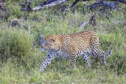
Leopard
The leopard is a strong, spotted big cat and the best climber of them all. It can carry its food high up into a tree, away from lions and hyenas. Leopards live in more kinds of places than any other big cat, from deserts to rainforests, across Africa and Asia.
-
 Watch
3D
Animal
Wild boar
Wild boars are bristly wild pigs that live in forests and fields across Europe, Asia and North Africa. They sniff out food with their powerful snouts, live in family groups called sounders, and are the wild ancestors of farm pigs.
Explore next
-
Watch
Natural wonder
Mount Ararat
Mount Ararat is a huge volcanic mountain in the far east of Türkiye, close to where Türkiye, Iran and Armenia meet. It has two peaks: Great Ararat, about 5,165 meters high and the tallest mountain in Türkiye, and the smaller, cone-shaped Little Ararat. Snow covers the top all year, and a glacier clings to its north side.
-
Watch
Animal
Eurasian lynx
The Eurasian lynx is the largest of the four kinds of lynx. It has black ear tufts, a ruff of fur around its face, a short black-tipped tail and big furry paws for snow. It hides in forests and ambushes deer such as roe deer, and it has returned to parts of Europe where it had disappeared.
-
Watch
3D
Animal
Leopard
The leopard is a strong, spotted big cat and the best climber of them all. It can carry its food high up into a tree, away from lions and hyenas. Leopards live in more kinds of places than any other big cat, from deserts to rainforests, across Africa and Asia.
-
Watch
3D
Animal
Wild boar
Wild boars are bristly wild pigs that live in forests and fields across Europe, Asia and North Africa. They sniff out food with their powerful snouts, live in family groups called sounders, and are the wild ancestors of farm pigs.
-
 Watch
 Country
Afghanistan
Afghanistan is a landlocked country in south-central Asia. The high Hindu Kush mountains run across its middle, sandy deserts lie in the southwest, and the capital, Kabul, sits in a valley about 1,800 meters above sea level.
-
 Watch
 Country
Azerbaijan
Azerbaijan is a country on the southern side of the Caucasus Mountains, along the western shore of the Caspian Sea. It has high mountains, wide lowlands and forests, its capital is Baku, and about 10.3 million people lived there in mid-2026.
-
 Watch
 Country
Indonesia
Indonesia is a country of about 17,500 islands in Southeast Asia, spread across the Equator between the Indian and Pacific oceans. It has more than 100 active volcanoes, rainforests full of wildlife, and about 286 million people (2025).
-
 Watch
 Country
Japan
Japan is an island country in East Asia. Most of its land is steep mountains and forest, Mount Fuji is its tallest peak, and about 124 million people live there, many of them in big cities such as Tokyo.
For parents & teachers
What children will learn
- Locate Armenia, name its four neighbors and explain what landlocked means.
- Describe how Armenia's land and plant life change with height, from semidesert to alpine meadow.
- Describe Armenian language, writing and food, such as lavash, without treating them as one single culture.
- Outline Armenia's history from Erebuni (783 BCE) to independence in 1991.
Recommended ages: 3 to 17 · About 15 minutes
Talk about it
- How might living in a country with no coast change how people travel and trade?
- Why do you think plants and animals change as you go higher up a mountain?
- Armenian has its own alphabet. What other alphabets or writing systems do you know?
Try at home or in class
- On a map, find Armenia and its four neighbors, then find the Black Sea and the Caspian Sea on either side of the Caucasus.
- Draw a tall mountain and divide it into bands for semidesert, steppe, forest, alpine meadow and tundra, then add one animal to each band you have read about.
Key vocabulary: landlocked, plateau, extinct volcano, exclave, alphabet, monastery, World Heritage Site
Where these facts come from
- Wikidata , Wikimedia Foundation (CC0 1.0)
- Natural Earth vector data , Natural Earth (NACIS) (Public domain)
- UNESCO World Heritage List , UNESCO World Heritage Centre (Linked as a reference; site facts come from Wikidata)
- Armenia , Encyclopaedia Britannica
- Armenia: Settlement patterns, demographic trends and economy , Encyclopaedia Britannica
- Armenia: History , Encyclopaedia Britannica
- Yerevan , Encyclopaedia Britannica
- Lake Sevan , Encyclopaedia Britannica
- Mount Aragats , Encyclopaedia Britannica
- Armenian alphabet , Encyclopaedia Britannica
- Armenia's permanent population increases by 14,300 in 2025 (Statistical Committee of Armenia figures) , Armenpress
- Monastery of Geghard and the Upper Azat Valley , UNESCO World Heritage Centre
- Lavash, the preparation, meaning and appearance of traditional bread as an expression of culture in Armenia , UNESCO Intangible Cultural Heritage
- Nagorno-Karabakh , Encyclopaedia Britannica
- Armenian Genocide , Encyclopaedia Britannica
- PlayOwl region table, version 1 , PlayOwl (PlayOwl original data)
- flag-icons 7.5.0 , Panayiotis Lipiridis and contributors (MIT)
- Wikimedia Commons , Wikimedia Foundation (Per file (public domain, CC0, CC BY or CC BY-SA); see each media record)
Checked, not yet human-reviewed. Last updated October 24, 2026. Spotted a mistake? Tell us.