 Country
Asia
Cyprus
Cyprus is a sunny island in the Mediterranean Sea. It has two mountain ranges, warm beaches and very old towns.
Cyprus is the third-largest island in the Mediterranean Sea, after Sicily and Sardinia. It has two mountain ranges with a flat plain between them, hot dry summers and rainy winters, and its first known village was built about 9,000 years ago.
Cyprus lies in the eastern Mediterranean, about 65 km south of Türkiye (Turkey) and 100 km west of Syria. Its Troodos Mountains formed from molten rock beneath an ancient ocean, its Neolithic village at Choirokoitia is a World Heritage Site, and Cyprus's Statistical Service estimated 983,000 people (end of 2024) in the area controlled by the government of the Republic of Cyprus.
Discover Cyprus
Cyprus is an island country.
The warm Mediterranean Sea is all around it. Cyprus has two lines of mountains. Between them is a wide, flat plain. The capital city is called Nicosia.
Cyprus is an island in the eastern Mediterranean Sea. It is the third-largest island in that sea, after Sicily and Sardinia, and it measures about 225 kilometers from its western cape to the tip of its long northeastern peninsula.
On a map, the island looks a little like a saucepan, with the handle pointing northeast. The Kyrenia Mountains run along the north coast and the Troodos Mountains rise in the south and west. Between them lies a flat plain, and in the middle of it stands Nicosia, the capital. About 1.4 million people live in Cyprus (World Bank estimate, 2025). Most speak Greek or Turkish, and many also speak English.
Cyprus lies in the eastern Mediterranean, about 65 km south of Türkiye (Turkey), 100 km west of Syria and 770 km southeast of mainland Greece. Britannica gives its greatest length as 225 km, from Cape Arnauti in the west to Cape Apostolos Andreas at the end of the northeastern peninsula, and its greatest north-south width as 100 km; the coastline runs for roughly 640 km.
Two mountain systems frame the island: the limestone Kyrenia range along the north coast and the igneous Troodos massif in the south and southwest, with the flat Mesaoria Plain between them. Population figures depend on scope. Cyprus's Statistical Service (CYSTAT) estimated 983,000 people at the end of 2024 in the area controlled by the government of the Republic of Cyprus, while the World Bank's estimate for Cyprus was 1,370,754 (2025). Greek and Turkish are the main languages, and English is widely spoken.
Cities and famous places
Nicosia is the capital city.
It has old stone walls around its oldest part. Paphos is a town by the sea. Its old floors are covered with tiny colored stones. These pictures are called mosaics.
Nicosia lies near the middle of the island, beside the Pedieos River on the Mesaoria Plain. It has been the seat of government of Cyprus since the 900s. Its old town is ringed by stone walls that the Venetians rebuilt about 5 kilometers around, and its Cyprus Museum holds many treasures found by archaeologists.
Other towns include Limassol, Larnaca and Paphos. At Paphos, people have found the remains of villas, palaces, theaters and tombs, and floors decorated with mosaics, pictures made of tiny pieces of stone. In the Troodos Mountains, ten churches and monasteries are covered inside with painted walls.
Nicosia, capital of the Republic of Cyprus, lies on the Pedieos River in the center of the Mesaoria Plain. Known in antiquity as Ledra, it has been the island's seat of government since the 10th century. Its fortifications, first raised by the Lusignan kings and later rebuilt by the Venetians around a smaller area about 5 km round, enclose the old town; the Cyprus Museum houses major archaeological collections.
UNESCO lists three sites. Paphos (1980), inhabited since the Neolithic period, has remains of villas, palaces, theaters, fortresses and tombs, and UNESCO counts the mosaics of Nea Paphos among the most beautiful in the world. The Painted Churches in the Troodos Region (1985) are ten churches and monasteries, from small rural buildings to the monastery of St John Lampadistis, whose murals give an overview of Byzantine and post-Byzantine painting in Cyprus. Choirokoitia (1998) is a Neolithic settlement occupied from the 7th to the 4th millennium BCE. Britannica adds that the ancient theater of Kourion has been restored and plays are staged there.
Mountains, plains and weather
Cyprus has two lines of mountains.
The tallest mountain is Mount Olympus. In winter, snow falls on the high mountains. Summers are hot and dry. Most rain falls in winter.
The Kyrenia Mountains stretch for about 160 kilometers along the north coast. They are made mostly of limestone, and one peak has five rocky points, like fingers. The Troodos Mountains in the south are made of a different rock. Geologists think it formed from melted rock beneath a deep ocean that once separated Europe and Asia from Africa and Arabia. Their highest point, Mount Olympus, is 1,951 meters high.
Between the two ranges lies the Mesaoria Plain, whose name means "Between the Mountains." Summers, from June to September, are hot and dry, and winters are rainy. The main rivers start in the Troodos and are fed only by winter rain, so in summer they dry up.
The Kyrenia range, also called the Pentadaktylos in the west for its five-fingered peak, runs 160 km parallel to the north coast. It is built largely of deformed Mesozoic limestone and is the southernmost range of the Alpine-Himalayan chain in the eastern Mediterranean. The Troodos massif is igneous: geologists conclude it formed from molten rock beneath the deep Tethys Ocean that once separated Eurasia and Afro-Arabia. It stretches about 80 km east to Stavrovouni (689 m), and its summit, Mount Olympus (also called Mount Troodos), reaches 1,951 m, the island's highest point.
The climate is intensely Mediterranean: hot, dry summers (June to September) and rainy winters (November to March), with short, changeable autumns and springs. Average precipitation is about 500 mm a year, from 350 mm at Nicosia to 1,050 mm on Mount Olympus. Nicosia's summer days average a maximum of 37 °C, and from December to March the Troodos has weeks of frosty nights and considerable snow. The major rivers, the largest being the Pedieos, rise in the Troodos and run dry in summer. Pine, dwarf oak, cypress and cedar forest cover the Troodos, while olive, carob and citrus trees grow on the narrow northern coastal plain.
Animals of Cyprus
Sea turtles come to the beaches of Cyprus.
They lay their eggs there. A kind of wild sheep lives in a forest in the mountains. Millions of birds fly over Cyprus in spring and autumn.
Green turtles and loggerhead turtles breed on beaches along the coast of Cyprus, and the law protects them. High in the Troodos Mountains, a small forest is home to the agrino, a wild sheep related to the mouflon. It is the only large wild animal left on the island, and it is strictly protected.
Cyprus also lies on major routes that birds use when they migrate. In spring and autumn, millions of birds pass over the island, and many kinds stay there for the winter. Long ago, the island had elephants and hippopotamuses: their fossils have been found near Kyrenia.
Britannica describes the agrino, a subspecies of wild sheep related to the mouflon of the western Mediterranean, as the only large wild animal now surviving on Cyprus; it is under strict protection in a small forested area of the Troodos range. Green and loggerhead turtles, both protected by law, breed on beaches along the coast.
The island lies on major bird migration routes: in spring and autumn millions of birds pass over it, and many species spend the winter, while francolin and chukar partridges are among the resident species. The fossil record shows how different the island once was: remains of elephants and hippopotamuses have been found in the Kyrenia area, and in ancient times deer and wild boar were numerous. Snakes were so common in antiquity that the island was called Ophiussa, "the Abode of Snakes"; Britannica notes they are now relatively rare.
People, languages and food
Many people in Cyprus speak Greek. Others speak Turkish.
Many people speak English too. A cheese called halloumi comes from Cyprus. Meals often have fresh fruit and vegetables.
About 1.4 million people live in Cyprus (2025 estimate), and more than two-thirds of them live in towns and cities. Most people speak Greek, and a smaller group speaks Turkish. A few thousand people speak Arabic or Armenian, and English is widely spoken and understood.
Cypriot cooking mixes traditions from Greece, Anatolia and the lands to the east, but some dishes are found only in Cyprus, such as halloumi cheese and pourgouri, a dish of boiled cracked wheat. Many meals begin with meze, lots of small plates to share. Cyprus is also known for handmade lace, especially from the town of Lefkara, and for silverwork.
Britannica describes two main communities: Greek Cypriots, nearly four-fifths of the population, whose ancestors include early inhabitants and settlers from the Peloponnese from about 1200 BCE; and Turkish Cypriots, roughly one-fifth, descended from Ottoman soldiers who arrived in 1571 and from settlers from Anatolia. Small Arabic-speaking Maronite and Armenian-speaking groups, each of a few thousand people, are mostly bilingual, and English is widely spoken. Greek Cypriots are primarily Eastern Orthodox Christians, and Turkish Cypriots are Sunni Muslims; there are also smaller Maronite, Armenian, Roman Catholic and Anglican communities. More than two-thirds of the population is urban.
In the government-controlled area, CYSTAT reports that 15.2 percent of people were under 15 and 18.3 percent were 65 or older in 2024, compared with 22.3 and 11.3 percent in 2000. The island's food draws on the Levant, Anatolia and Greece, with purely Cypriot dishes such as halloumi cheese and pourgouri; meze often takes the place of a main course. Lefkara lacework and silversmithing are among the best-known crafts of both communities.
A long history
People have lived on Cyprus for a very long time.
Long ago, people built round stone houses there. Many different rulers came over the years. In 1960, Cyprus became its own country.
About 9,000 years ago, people at Khirokitia (also spelled Choirokoitia), near the south coast, lived in round, two-story houses made of stone. Later, Cyprus traded with Crete, Syria and Egypt, and for many centuries it was known for its copper. Settlers from Greece arrived after about 1200 BCE, and Greek has been the main language for about 3,000 years.
Over the centuries the island was ruled by many powers in turn, including the Byzantine Empire, the Lusignan kings, the Republic of Venice, the Ottoman Empire from 1571 and Britain from 1878. In 1960 Cyprus became an independent republic, and in 2004 it joined the European Union.
Artifacts at Aetokremnos on the south coast date to about 12,000 years ago, and the first known settlement, Khirokitia (Choirokoitia), dates from as early as 9,000 years ago. In the Late Bronze Age the island's contacts reached from the Aegean to the Levant and the Nile delta; Greek immigration from the Peloponnese after 1200 BCE led to Greek kingdoms, and a Phoenician colony was founded at Kition about 800 BCE. Cyprus was later part of the Byzantine Empire, was sold by Richard I of England to Guy of Lusignan, whose dynasty ruled from 1192 until Venice took over in 1489, and was conquered by the Ottomans in 1570-71. Britain took over its administration in 1878, annexed it in 1914 and made it a crown colony in 1925.
Cyprus became an independent republic on August 16, 1960, and joined the United Nations, with Britain keeping sovereignty over bases at Akrotiri and Dhekelia. Britannica writes that the long-standing conflict between the Greek Cypriot majority and the Turkish Cypriot minority deepened after independence, and a UN peacekeeping force was sent in 1964. In July 1974 a coup by a National Guard detachment led by officers from mainland Greece was followed by the landing of Turkish forces, and by mid-August Turkey controlled roughly the northern third of the island. Britannica describes the resulting partition as real on the ground but not recognized internationally. Turkish Cypriot leaders proclaimed the Turkish Republic of Northern Cyprus in the north in 1983; only Turkey recognizes it, and the UN Security Council condemned the declaration. Today the Republic of Cyprus, a UN member since 1960, governs the south of the island apart from the British bases, and the north is administered by the Turkish Cypriots; the operating zone of the UN force in Cyprus separates the two, running through Nicosia. The Republic joined the European Union in 2004 and adopted the euro in 2008.
Cyprus on the map
Find Cyprus on the globe.
Look at the far east end of the Mediterranean Sea. Cyprus is an island, so the sea is all around it. Türkiye and Syria are across the water.
Cyprus is in the eastern corner of the Mediterranean Sea. Türkiye (Turkey) is about 65 kilometers to the north and Syria about 100 kilometers to the east, while mainland Greece is about 770 kilometers away to the northwest. Because it is an island, its nearest neighbors are all across the sea.
The island's coast is rocky in many places, with long sandy beaches between the rocks. Its long peninsula points to the northeast.
Cyprus lies in the eastern Mediterranean, 65 km south of Türkiye (Turkey), 100 km west of Syria and 770 km southeast of mainland Greece. It is 225 km long and 100 km wide at most, with an indented, rocky coastline of roughly 640 km and long sandy beaches. The Republic of Cyprus is a member of the European Union.
The Mesaoria Plain stretches across the middle of the island from Morphou Bay in the west to Famagusta Bay in the east. Two areas, Akrotiri and Dhekelia, have remained under British sovereignty as military bases since 1960. Figures for the island depend on scope: CYSTAT's population counts cover only the area controlled by the government of the Republic of Cyprus.
- Greatest length
- 225 km (Cape Arnauti to Cape Apostolos Andreas)
- Greatest width, north to south
- 100 km
- Distance to the nearest mainland
- about 65 km south of Türkiye (Turkey)
- Coastline
- about 640 km
- Highest point
- Mount Olympus, 1,951 m
Amazing facts
-
Long ago, elephants and hippos lived on Cyprus.
Fossils of elephants and hippopotamuses have been found near Kyrenia, on the north coast of Cyprus.
Britannica records fossil remains of elephants and hippopotamuses from the Kyrenia area, and large numbers of deer and boar in ancient times.
-
Long ago, Cyprus had a nickname about snakes.
Snakes were once so common on Cyprus that the island was called Ophiussa, which means "the Abode of Snakes." Today they are fairly rare.
Snakes were widespread in antiquity, giving the island the name Ophiussa, "the Abode of Snakes"; Britannica notes they are now relatively rare.
-
Cyprus was famous for a shiny metal called copper.
Cyprus produced copper for many centuries, and in Greek the name of the island and the name of the metal are the same.
Britannica notes that Cyprus was for many centuries a noted producer of copper and that in Greek the island's name and the metal's are identical; the main mines were around Skouriotissa.
-
The rivers of Cyprus dry up in summer.
The rivers of Cyprus are fed only by winter rain, so in the hot, dry summer they become dry beds.
All the island's major rivers rise in the Troodos and are fed entirely by runoff from winter precipitation; in summer they become dry courses.
-
Old floors in Paphos are covered with tiny stone pictures.
The mosaics of Nea Paphos are counted by UNESCO among the most beautiful in the world.
UNESCO inscribed Paphos in 1980 for its villas, palaces, theaters, fortresses and tombs, describing the mosaics of Nea Paphos as among the most beautiful in the world.
Words to know
- island
- a piece of land with water all around it
- plain
- a wide area of flat, low land
- mosaic
- a picture made by fitting together many tiny pieces of stone, glass or tile
- migration
- a long journey animals make between places at certain times of year
- Neolithic
- the late Stone Age, when people began farming and building villages
- meze
- many small dishes served together to share, often at the start of a meal
- World Heritage Site
- a place UNESCO lists as important to all people, to be protected
Discovery challenge
-
What is the capital city of Cyprus?
Which city is the capital of Cyprus?
Which city, on the Mesaoria Plain, is the capital of the Republic of Cyprus?
- Nicosia
- Paphos
- Limassol
Show the answer
Nicosia
Nicosia is the capital. It is in the middle of the island.
Nicosia, near the middle of the island, has been the seat of government since the 900s.
Nicosia, on the Pedieos River in the center of the Mesaoria Plain, has been the island's seat of government since the 10th century.
-
Which sea is all around Cyprus?
In which sea is Cyprus the third-largest island?
Cyprus is the third-largest island, after Sicily and Sardinia, of which sea?
- Baltic Sea
- Mediterranean Sea
- Caribbean Sea
Show the answer
Mediterranean Sea
The Mediterranean Sea is all around Cyprus.
Cyprus is the third-largest island in the Mediterranean, after Sicily and Sardinia.
It lies in the eastern Mediterranean, 65 km south of Türkiye and 100 km west of Syria.
-
Which animals lay eggs on the beaches of Cyprus?
Which animals come ashore to breed on the beaches of Cyprus?
Which animals, protected by law in Cyprus, breed on its beaches?
- Penguins
- Crocodiles
- Sea turtles
Show the answer
Sea turtles
Sea turtles lay their eggs in the sand.
Green turtles and loggerhead turtles breed on the beaches, and the law protects them.
Green and loggerhead turtles, both protected by law, breed on beaches along the coast of Cyprus.
-
What is the tallest mountain on Cyprus?
Which mountain is the highest point of Cyprus?
Which summit of the Troodos range, 1,951 m high, is the island's highest point?
- Mount Everest
- Mount Olympus
- Mount Kenya
Show the answer
Mount Olympus
Mount Olympus is the tallest. Snow falls there in winter.
Mount Olympus, 1,951 meters high, is the top of the Troodos Mountains.
Mount Olympus, also called Mount Troodos, is the summit of the igneous Troodos massif at 1,951 m.
-
Which cheese comes from Cyprus?
Which cheese is a Cypriot food?
Which cheese is among the island's purely Cypriot dishes?
- Halloumi
- Cheddar
- Parmesan
Show the answer
Halloumi
Halloumi cheese comes from Cyprus.
Halloumi is a cheese from Cyprus, one of the dishes found only on the island.
Britannica lists halloumi, with pourgouri (boiled cracked wheat), among the purely Cypriot dishes in a cuisine that draws on the Levant, Anatolia and Greece.
Animals of Cyprus
-
 Watch
Animal
Loggerhead sea turtle
The loggerhead sea turtle is named for its huge head and powerful jaws, which crush crabs, conchs and other hard-shelled animals. Babies hatch on sandy beaches, ride the open ocean for years and may cross an entire ocean before coming home to nest.
-
 Watch
Animal
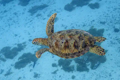
Green sea turtle
The green sea turtle is the largest sea turtle with a hard shell. It lives in warm seas around the world and, unlike other sea turtles, grown-ups eat mostly seagrass and algae. Females swim hundreds or even thousands of kilometers to lay their eggs on the beaches where they hatched long ago.
Explore next
-
Watch
Animal
Loggerhead sea turtle
The loggerhead sea turtle is named for its huge head and powerful jaws, which crush crabs, conchs and other hard-shelled animals. Babies hatch on sandy beaches, ride the open ocean for years and may cross an entire ocean before coming home to nest.
-
Watch
Animal
Green sea turtle
The green sea turtle is the largest sea turtle with a hard shell. It lives in warm seas around the world and, unlike other sea turtles, grown-ups eat mostly seagrass and algae. Females swim hundreds or even thousands of kilometers to lay their eggs on the beaches where they hatched long ago.
- Watch Geography What is a World Heritage Site? World Heritage Sites are places so important that they belong, in a way, to everyone. Under a 1972 agreement, countries nominate their most outstanding places, experts check them, and a UNESCO committee decides. By 2026 the list held 1,273 sites: cultural places like the Taj Mahal, natural places like the Galápagos, and mixed ones like Machu Picchu.
-
 Watch
 Country
Afghanistan
Afghanistan is a landlocked country in south-central Asia. The high Hindu Kush mountains run across its middle, sandy deserts lie in the southwest, and the capital, Kabul, sits in a valley about 1,800 meters above sea level.
-
 Watch
 Country
Azerbaijan
Azerbaijan is a country on the southern side of the Caucasus Mountains, along the western shore of the Caspian Sea. It has high mountains, wide lowlands and forests, its capital is Baku, and about 10.3 million people lived there in mid-2026.
-
 Watch
 Country
Indonesia
Indonesia is a country of about 17,500 islands in Southeast Asia, spread across the Equator between the Indian and Pacific oceans. It has more than 100 active volcanoes, rainforests full of wildlife, and about 286 million people (2025).
-
 Watch
 Country
Japan
Japan is an island country in East Asia. Most of its land is steep mountains and forest, Mount Fuji is its tallest peak, and about 124 million people live there, many of them in big cities such as Tokyo.
-
 Watch
 Country
Kyrgyzstan
Kyrgyzstan is a mountain country in Central Asia, with no coast on the sea. The high Tien Shan mountains cover much of it, and Lake Issyk-Kul, one of the largest high-mountain lakes in the world, lies in the northeast. Its capital is Bishkek.
For parents & teachers
What children will learn
- Locate Cyprus in the eastern Mediterranean and describe its two mountain ranges and central plain.
- Explain that the Troodos Mountains formed from rock that began beneath an ancient ocean.
- Describe the island's wildlife, languages, foods and crafts without treating them as one single culture.
- Outline the island's long history from the first villages to independence in 1960.
Recommended ages: 3 to 17 · About 15 minutes
Talk about it
- Why might the rivers of Cyprus be dry in summer but flowing in winter?
- Why do you think so many birds fly over an island like Cyprus on their journeys?
- UNESCO protects very old villages and painted churches. What old place near you would you want to protect?
Try at home or in class
- Trace the outline of Cyprus from a map and see whether it looks like a saucepan to you. Mark the two mountain ranges and the plain between them.
- Make a paper mosaic: cut colored paper into small squares and glue them into a simple picture, like the floors at Paphos.
Key vocabulary: island, plain, mosaic, migration, Neolithic, meze, World Heritage Site
Where these facts come from
- Wikidata , Wikimedia Foundation (CC0 1.0)
- Natural Earth vector data , Natural Earth (NACIS) (Public domain)
- UNESCO World Heritage List , UNESCO World Heritage Centre (Linked as a reference; site facts come from Wikidata)
- Cyprus (Land: relief, drainage, climate, plant and animal life) , Encyclopaedia Britannica
- Cyprus: People , Encyclopaedia Britannica
- Cyprus: Economy , Encyclopaedia Britannica
- Cyprus: Cultural life , Encyclopaedia Britannica
- Cyprus: History , Encyclopaedia Britannica
- Cyprus: Byzantine Empire , Encyclopaedia Britannica
- Cyprus: Ottoman rule , Encyclopaedia Britannica
- Cyprus: The Republic of Cyprus , Encyclopaedia Britannica
- Nicosia , Encyclopaedia Britannica
- Demographic Statistics 2024 (press release, 19 December 2025) , Statistical Service of the Republic of Cyprus (CYSTAT)
- Population, total - Cyprus , World Bank
- Paphos , UNESCO World Heritage Centre
- Painted Churches in the Troodos Region , UNESCO World Heritage Centre
- Choirokoitia , UNESCO World Heritage Centre
- PlayOwl region table, version 1 , PlayOwl (PlayOwl original data)
- flag-icons 7.5.0 , Panayiotis Lipiridis and contributors (MIT)
Checked, not yet human-reviewed. Last updated October 24, 2026. Spotted a mistake? Tell us.