
 Country
Africa
Eritrea
Eritrea is a country in Africa next to the Red Sea. It has cool highlands, a very hot coast and more than 100 little islands.
Eritrea is a country in the Horn of Africa with a long coast on the Red Sea. Its capital, Asmara, sits high in cool mountains, while the coast below has one of the highest average temperatures in the world. About 3.6 million people live there, and its name comes from the Latin words for the Red Sea.
Eritrea, on the Red Sea in the Horn of Africa, rises from a scorching coastal plain and the below-sea-level Danakil to central highlands over 2,000 m high. A former Italian colony, later federated with and then annexed by Ethiopia, it became independent in 1993; it had about 3.6 million people in 2025 (World Bank estimate).
Photo: I, Sailko, CC BY-SA 3.0, via Wikimedia Commons
Discover Eritrea
Eritrea is a country in Africa.
It is next to the Red Sea. High mountains run down the middle. The capital city is Asmara.
Eritrea is in the Horn of Africa, the part of eastern Africa shaped like a horn. Its coast runs for about 1,000 kilometers along the Red Sea, and its name comes from Mare Erythraeum, the old Latin name for the Red Sea.
A strip of highlands about 2,000 meters high runs down the middle of the country. Asmara, the capital and largest city, is up there. Eritrea became an independent country in 1993. The World Bank estimated about 3.6 million people lived there in 2025.
Eritrea lies in the Horn of Africa on the Red Sea, with a coastline of roughly 1,000 km from Cape Kasar in the north to the Strait of Mandeb, which separates the Red Sea from the Gulf of Aden. Its name is an Italianized form of Mare Erythraeum, Latin for Red Sea; Britannica notes that the Red Sea brought Christianity and Islam to the area and made its ports prizes for Turkey, Egypt and Italy.
The country became sovereign in 1993. Asmara, the capital and largest city, stands on the central highlands. The World Bank's model estimate for 2025 is 3,607,003 people. About two-fifths of the population is under 15, and by the early 21st century about two-fifths was urban.
Cities and old places
Asmara is the capital city.
It sits high up in the mountains. It has many unusual old buildings. Massawa is a hot port town by the sea.
Asmara stands more than 2,000 meters above sea level. Italy ruled Eritrea from 1890, and in the 1930s builders filled Asmara with bold, modern buildings: offices, homes, shops, cinemas and places of worship. Today the city is a World Heritage Site, listed in 2017 as a modernist African city.
Massawa is an old port on the Red Sea with long links to Arabia. High on the Qohaito plateau, at about 2,600 meters, are the ruins of an ancient town that traded through the old port of Adulis about 1,300 to 1,900 years ago.
UNESCO inscribed Asmara: A Modernist African City in 2017. Developed as an Italian military outpost from the 1890s, it was planned in phases between 1893 and 1941; after 1935 a large building program applied the Italian rationalist style to government buildings, homes, shops, cinemas, churches, mosques and synagogues. UNESCO calls it an exceptional example of early modernist urbanism in Africa and notes that the planning also followed principles of racial segregation.
Massawa, an old cosmopolitan port with strong links to Arabia, was greatly expanded under Italy, and Asseb was developed as a new port. Eritrea's tentative World Heritage list includes Qohaito, a 32 km² plateau at 2,600–2,700 m whose town prospered before and during the Aksumite period (about 100–700 CE), astride routes from the ancient Red Sea port of Adulis, and was abandoned around 900 CE.
Highlands, hot coast and the Danakil
The mountains in Eritrea are cool.
The coast by the sea is very hot. In one dry place, the land is lower than the sea! Little coral islands sit in the Red Sea.
In the middle of Eritrea, the highlands rise about 2,000 meters, cut by deep gorges into flat-topped hills called ambas. To the east, the land drops steeply to a hot coastal plain. In the south is the Danakil Plain, where part of the ground is more than 90 meters below sea level and it almost never rains.
Massawa, on the coast, averages about 30 °C, while Asmara, only 65 kilometers away but about 2,300 meters higher, averages about 17 °C. Off the coast lie the Dahlak islands, more than 100 small coral islands.
The central highlands, a narrow north–south strip at about 2,000 m, are the northern end of the Ethiopian Plateau: crystalline basement rock overlain by limestone and sandstone and capped by basalt, dissected into steep-sided, flat-topped ambas. Mount Soira, about 3,013 m by Britannica's figure, is the highest point. Eastward the plateau drops abruptly to a coastal plain 15–80 km wide north of the Gulf of Zula; to the south the Danakil Plain, part of the East African Rift System, includes the northern end of the Kobar Sink, more than 90 m below sea level. The western plain averages 460 m, with savanna. The Gash (Mereb upstream) and Tekezē flow west toward the Atbara and the Nile; the Baraka and Anseba flow north into Sudan.
Elevation drives the climate: Massawa averages about 30 °C, among the highest averages in the world, while Asmara, 65 km away and roughly 2,300 m higher, averages about 17 °C. The plateau gets about 400–500 mm of rain, mainly in summer; the eastern edges and coast get some winter and spring rain, and the interior of the Danakil is practically rainless.

Animals of Eritrea
Gentle dugongs graze on sea grass in the Red Sea.
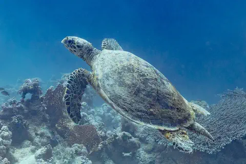
Sea turtles swim over the coral. On land live rare wild donkeys, called wild asses, and leopards.
Eritrea's seas are full of life. About 500 kinds of fish live off its coast, along with five kinds of sea turtles, dolphins and whales, and the dugong, a gentle sea mammal that eats sea grass. There are coral reefs, sea grass beds and mangroves.
On land, scientists have counted 126 kinds of mammals and 557 kinds of birds. Some large animals, such as the African wild ass, the elephant and the greater kudu, have become rare after many years of drought and damage to the land. A report to the Convention on Biological Diversity says that areas closed to woodcutting and grazing have helped some of them, and the leopard, increase in number.
The Convention on Biological Diversity's country profile (a draft prepared by its secretariat) records 126 mammal species, including 9 marine mammals, 557 birds, 90 reptiles and 19 amphibians. The marine and coastal zone in the southern Red Sea holds about 500 fish species, 5 marine turtle species, 8 or more cetaceans and the dugong, with coral reefs, seagrass beds and mangroves; Eritrea is also a center of origin and diversity for sorghum, wheat and barley.
The profile describes severe land degradation after 30 years of armed struggle, drought and neglect, and lists the elephant, wild ass, greater kudu and civet as in danger of national extinction. Eritrea had no formally protected areas, but by 1999 about 192,734 ha had been closed to wood cutting and grazing, and the profile reports rising numbers of African wild ass, African elephant, greater kudu, leopard, sea turtles, dugongs and sharks. Threats at sea include coastal development and destructive trawling.
People, languages and daily life
About 3.6 million people live in Eritrea.
Many people speak Tigrinya or Tigré. Many families farm and keep sheep, goats and camels.
About half the people are Tigrinya, who live mostly in the highlands, and nearly a third are Tigre, in the north and the lowlands. Their two languages are written in the same script, but speakers of one cannot understand the other. The Afar, Saho, Beja, Bilin, Kunama, Nara and Rashaida are other peoples of Eritrea. Arabic and English are widely understood.
About four out of five people make a living from farming or herding. Farmers grow sorghum, millet and a local grain called teff, and herders keep sheep, cattle, goats and camels.
The Tigray (often called Tigrinya in Eritrea) make up about half the population and live mainly on the plateau; the Tigre, nearly one-third, live in the north and the lowlands. Tigrinya and Tigré share a script and descend from ancient Ge'ez but are mutually unintelligible. Other groups include the Bilin, whose language is Cushitic, the Afar, Saho and Beja, the Arabic-speaking Rashaida (the only truly nomadic group), and the Nilotic-speaking Kunama and Nara. Arabic and English are widely understood. About half the population is Christian and about half Muslim.
The plateau, a quarter of the land, holds about half the people, mostly settled farmers; the lowlands support mainly pastoralists, who also grow crops when rain allows. Agriculture supports about four-fifths of people; staples are sorghum, millet and teff, with sheep, cattle, goats and camels. Salt is mined in the Kobar Sink, the Bisha gold mine opened in 2011, and Red Sea fish are a significant export.

Ports, colonies and independence
People have lived in Eritrea for a very long time.
Long ago, ships came to its ports to trade. Later, Italy ruled the land. In 1993, Eritrea became its own country.
Nearly 2,000 years ago, towns in Eritrea's highlands traded through the port of Adulis on the Red Sea. Christianity reached the coast in the 300s, and Islam arrived across the Red Sea from the 600s. For centuries, powers such as the Ottoman Turks and Egypt held ports like Massawa.
On January 1, 1890, Italy declared Eritrea a colony. Britain took over in 1941, and in 1952 Eritrea was joined to Ethiopia. In 1993 Eritreans voted for independence, and Eritrea became a new country.
Qohaito and the port of Adulis flourished before and during the Aksumite period (about 100–700 CE). Christianity was established on the coast in the 4th century; after the 7th century Muslim power spread along the coast and lowlands. The Ottoman Turks held the Dahlak islands and Massawa from the 16th century, and Egypt obtained Massawa in 1865. After the Suez Canal opened in 1869, Italy acquired land around Asseb, landed at Massawa in 1885 and proclaimed the colony of Eritrea on January 1, 1890.
Britain ousted Italy in 1941 and administered the territory until a UN-arranged federation with Ethiopia in 1952. Ethiopia ended the federation in 1962, making Eritrea a province, and an independence war began that lasted nearly three decades, until the Eritrean People's Liberation Front took control in May 1991. In an April 1993 referendum the great majority voted for independence, declared on May 24, 1993, with Isaias Afwerki as president. A border war with Ethiopia followed in 1998–2000; in 2018 the two governments declared the state of war over. Britannica notes that the constitution ratified in 1997 had not been put into effect and that national elections had been postponed indefinitely.
Eritrea on the map
Find Eritrea on the globe.
It is in Africa, next to the long Red Sea. Across the sea is Arabia. Three countries are its neighbors.
Eritrea's long coast faces northeast onto the Red Sea, with Arabia on the other side. Sudan is to the west, Ethiopia to the south and Djibouti to the southeast.
At Eritrea's southern tip is the Strait of Mandeb, the narrow gateway between the Red Sea and the Gulf of Aden. The Dahlak islands lie offshore in the Red Sea.
Eritrea's coastline forms the country's northeastern edge, from Cape Kasar to the Strait of Mandeb. It is bounded by Djibouti to the southeast, Ethiopia to the south and Sudan to the west. On the plateau the Mereb (upper Gash) forms the border with Ethiopia, and in the western lowlands the Tekezē forms part of it.
A border dispute with Ethiopia centered on Badme led to war in 1998–2000; a boundary commission ruled on the line in 2002, and Ethiopia announced in 2018 that it would accept that ruling. The Hanish Islands in the Red Sea, disputed with Yemen in 1995–96, were ultimately recognized as Yemeni.
- Coastline
- about 1,000 km, from Cape Kasar to the Strait of Mandeb
- Neighbors
- Sudan, Ethiopia and Djibouti
- Dahlak Archipelago
- more than 100 small coral islands
- People (2025, estimate)
- 3,607,003
Amazing facts
-
Eritrea's name means the Red Sea.
The name Eritrea comes from Mare Erythraeum, the old Latin name for the Red Sea.
Eritrea is an Italianized version of Mare Erythraeum, Latin for Red Sea, reflecting how central the coast has been to its history.
-
Part of Eritrea is lower than the sea.
In the Danakil Plain, part of the ground in the Kobar Sink is more than 90 meters below sea level, and it almost never rains there.
The northern end of the Kobar Sink, more than 90 m below sea level, extends into Eritrea's Danakil Plain, part of the East African Rift System; its interior is practically rainless.
-
The capital, Asmara, is a World Heritage city.
Asmara, built up with bold modern buildings in the 1930s, became a World Heritage Site in 2017.
UNESCO inscribed Asmara in 2017 as an exceptionally well-preserved colonial planned city, laid out between 1893 and 1941 in an orthogonal grid that later took in radial elements.
-
On a clear day, you can see the sea from an old hilltop town.
From the Qohaito plateau, about 2,600 meters high, the Red Sea can be seen on a clear day.
Eritrea's tentative-list entry for Qohaito notes that the Red Sea is visible from the plateau on a clear day, and that the site was abandoned around 900 CE.
Words to know
- highlands
- an area of high, hilly or mountainous land
- amba
- a steep-sided, flat-topped hill in the highlands of Eritrea and Ethiopia
- archipelago
- a group or chain of islands
- dugong
- a large, gentle sea mammal that grazes on sea grass
- modernist
- a style of building from the early 1900s with simple shapes and new materials such as concrete
- referendum
- a vote in which all the people decide one important question
- World Heritage Site
- a place UNESCO lists as important to all people, to be protected
Discovery challenge
-
Which sea is next to Eritrea?
Eritrea has a long coast on which sea?
Eritrea's name comes from the Latin name of which sea?
- The Black Sea
- The Red Sea
- The North Sea
Show the answer
The Red Sea
The Red Sea is next to Eritrea.
Eritrea's coast runs for about 1,000 kilometers along the Red Sea.
Eritrea comes from Mare Erythraeum, Latin for Red Sea.
-
What is the capital city of Eritrea?
Which city, high in the mountains, is Eritrea's capital?
Which capital did UNESCO list in 2017 as a modernist African city?
- Massawa
- Asmara
- Keren
Show the answer
Asmara
Asmara is the capital of Eritrea.
Asmara stands more than 2,000 meters above sea level.
Asmara: A Modernist African City was inscribed in 2017.
-
Where is it hotter, by the sea or in the mountains?
Which is warmer on average: Massawa on the coast or Asmara in the mountains?
Which Eritrean town has one of the highest average temperatures in the world, about 30 °C?
- Massawa, by the sea
- Asmara, in the mountains
- They are the same
Show the answer
Massawa, by the sea
It is hotter by the sea, at Massawa.
Massawa averages about 30 °C; Asmara, much higher, averages about 17 °C.
Massawa averages about 30 °C; Asmara, 65 km away and about 2,300 m higher, about 17 °C.
-
Which gentle sea animal eats sea grass near Eritrea?
Which sea mammal grazes on sea grass off Eritrea's coast?
Which seagrass-grazing marine mammal is recorded in Eritrea's southern Red Sea waters?
- The dugong
- The polar bear
- The walrus
Show the answer
The dugong
The dugong eats sea grass.
Dugongs live off Eritrea's coast, where there are sea grass beds and coral reefs.
The dugong is listed with five marine turtles and at least eight cetaceans in Eritrea's marine zone.
-
When did Eritrea become its own country?
In which year did Eritrea become independent?
In which year did a referendum lead to Eritrea's independence on May 24?
- 1890
- 1952
- 1993
Show the answer
1993
Eritrea became its own country in 1993.
Eritreans voted for independence in 1993.
The April 1993 referendum was followed by the declaration of independence on May 24, 1993; 1890 was the Italian colony and 1952 the federation with Ethiopia.
Places to discover in Eritrea
Animals of Eritrea
-
Watch
Animal
Dugong
The dugong is a large, slow marine mammal that grazes on seagrass meadows in warm, shallow coastal seas from East Africa to the western Pacific. It is a relative of the manatee and, surprisingly, more closely related to elephants than to cows. It has a whale-like tail, a big bristly snout and very good hearing.
-
Watch
3D
Animal
Hawksbill sea turtle
The hawksbill sea turtle lives in warm seas around the world, mostly near coral reefs. Its pointed, hawk-like beak reaches into cracks in the reef to find sponges, its favorite food. Its beautiful patterned shell once made it a target for hunters, and today it is critically endangered.
-
Watch
3D
Animal
Dromedary camel
The dromedary, or Arabian camel, is the one-humped camel of the deserts of North Africa, the Middle East and India. Its hump stores fat, not water, and its body is full of tricks for saving water. People tamed dromedaries thousands of years ago, and today none live truly wild, except a large feral population in Australia.
Explore next
-
 Watch
Natural wonder
Great Rift Valley
The Great Rift Valley is a huge valley that runs through East Africa, where the continent is slowly being stretched and pulled apart. Long, steep cliffs line its sides, its floor holds lakes full of flamingos, and giant volcanoes such as Kilimanjaro and Mount Kenya rose beside it. Scientists think a new ocean may one day open here.
-
Watch
Animal
Dugong
The dugong is a large, slow marine mammal that grazes on seagrass meadows in warm, shallow coastal seas from East Africa to the western Pacific. It is a relative of the manatee and, surprisingly, more closely related to elephants than to cows. It has a whale-like tail, a big bristly snout and very good hearing.
-
Watch
3D
Animal
Hawksbill sea turtle
The hawksbill sea turtle lives in warm seas around the world, mostly near coral reefs. Its pointed, hawk-like beak reaches into cracks in the reef to find sponges, its favorite food. Its beautiful patterned shell once made it a target for hunters, and today it is critically endangered.
-
Watch
3D
Animal
Dromedary camel
The dromedary, or Arabian camel, is the one-humped camel of the deserts of North Africa, the Middle East and India. Its hump stores fat, not water, and its body is full of tricks for saving water. People tamed dromedaries thousands of years ago, and today none live truly wild, except a large feral population in Australia.
-
 Watch
 Country
Ethiopia
Ethiopia is a country on the Horn of Africa with no coast. Much of it is high, rugged land cut by the Great Rift Valley, it is one of the world's oldest countries, and more than 110 million people live there.
-
 Watch
 Country
Djibouti
Djibouti is a small country in the Horn of Africa, where the Red Sea meets the Gulf of Aden. It is hot and dry, with volcanic rock everywhere, and Lake Assal, 155 meters below sea level, is the lowest point in Africa. About 1.2 million people lived there in 2025, most of them in the capital, also called Djibouti.
-
 Watch
 Country
Democratic Republic of the Congo
The Democratic Republic of the Congo, or DR Congo, is the second-largest country in Africa. The mighty Congo River curves through its rainforests, volcanoes rise in the east, and its capital, Kinshasa, is a center of music, fashion and popular culture.
-
 Watch
 Country
Kenya
Kenya is a country in East Africa, crossed by the equator. It has the snow-capped Mount Kenya, the deep Great Rift Valley, Lake Victoria and a long Indian Ocean coast, and about 54 million people live there, many of them speaking Swahili.
For parents & teachers
What children will learn
- Locate Eritrea, the Red Sea, its three neighbors and the Strait of Mandeb.
- Explain how height above sea level makes Asmara much cooler than Massawa.
- Describe the peoples, languages and ways of life of Eritrea without treating them as one culture.
- Outline Eritrea's history from ancient Red Sea trade to Italian rule and independence in 1993.
Recommended ages: 3 to 17 · About 15 minutes
Talk about it
- Why might a capital city be built high in the mountains instead of on the hot coast?
- What can old buildings, like Asmara's cinemas and offices, tell us about the past?
- How do herders who move with the seasons decide where to go?
Try at home or in class
- With a grown-up, compare the temperature in a sunny spot and a shady spot outside, and talk about why mountain towns are cooler.
- Draw a cross-section of Eritrea from the Red Sea to the highlands: a low coast, a steep slope, and a high plateau with Asmara on top.
Key vocabulary: highlands, amba, archipelago, dugong, modernist, referendum, World Heritage Site
Where these facts come from
- Wikidata , Wikimedia Foundation (CC0 1.0)
- Natural Earth vector data , Natural Earth (NACIS) (Public domain)
- UNESCO World Heritage List , UNESCO World Heritage Centre (Linked as a reference; site facts come from Wikidata)
- Eritrea (introduction, land, relief, drainage, climate, people, languages) , Encyclopaedia Britannica
- Eritrea: Religion (settlement, demographic trends, economy) , Encyclopaedia Britannica
- Eritrea: Contesting for the coastlands and beyond , Encyclopaedia Britannica
- Eritrea: Federation with Ethiopia , Encyclopaedia Britannica
- Eritrea: Independent Eritrea , Encyclopaedia Britannica
- Asmara: A Modernist African City , UNESCO World Heritage Centre
- Qohaito Cultural Landscape (Tentative List) , UNESCO World Heritage Centre
- Eritrea: Country profile (biodiversity facts) , Convention on Biological Diversity
- Population, total: Eritrea , World Bank
- Dugong , Australian Museum
- PlayOwl region table, version 1 , PlayOwl (PlayOwl original data)
- flag-icons 7.5.0 , Panayiotis Lipiridis and contributors (MIT)
- Wikimedia Commons , Wikimedia Foundation (Per file (public domain, CC0, CC BY or CC BY-SA); see each media record)
Checked, not yet human-reviewed. Last updated October 27, 2026. Spotted a mistake? Tell us.