
 Country
North America
Nicaragua
Nicaragua is the biggest country in Central America. It has a chain of volcanoes and a giant lake with islands in it. Jaguars and monkeys live in its forests.
Nicaragua is the largest of the Central American republics, with coasts on both the Pacific Ocean and the Caribbean Sea. A row of about 40 volcanoes runs along its Pacific side, and Lake Nicaragua, the largest lake in Central America, even has volcano islands. Most people live in the west, and the east has wide, rainy lowlands and forests.
Nicaragua, the largest Central American republic, is named for Nicarao, a chief of the people around Lake Nicaragua in the early 16th century. Colonized by Spain in the west and influenced by Britain on the Caribbean Mosquito Coast, it left the Central American federation in 1838. Its western volcanic belt and lake basin hold most people and industry. Its history includes U.S. interventions, the Somoza family's rule from 1936 to 1979, and the Sandinista revolution.
Photo: FurlongWiki, CC BY-SA 4.0, via Wikimedia Commons
Discover Nicaragua
Nicaragua is a country in Central America.
It has two coasts, one on each ocean side. It has volcanoes and big lakes. The capital city is Managua.
Nicaragua is in the middle of Central America, between Honduras and Costa Rica. It is the biggest of the Central American countries. To the west is the Pacific Ocean and to the east the Caribbean Sea.
Nicaragua's name comes from Nicarao, a chief of the people who lived around Lake Nicaragua about 500 years ago. Most people speak Spanish, and the capital, Managua, is the largest city. Almost everyone lives in the western half of the country, near the lakes and volcanoes.
Britannica characterizes Nicaragua by its agricultural economy, its history of autocratic government and its imbalance of regional development: almost all settlement and economic activity are concentrated in the western half. Nicaragua was, Britannica notes, the only Latin American country colonized by both Spain and Britain. Managua, the capital and largest city, holds about one-sixth of the population.
Britannica estimates about 7,019,000 people in 2026. That is an estimate: the last national census, in 2005, counted 5,142,098 people (Wikidata). Nearly three-fifths of people live in towns and cities. Spanish is the official language, with Miskito, Sumo (Mayangna), Rama and Creole English sharing official status on the Caribbean coast under the 1987 constitution.
Managua, León and Granada
Managua is the capital.
It is beside a big lake. León has a huge white cathedral. Granada is an old city on Lake Nicaragua.
Managua sits on the shore of Lake Managua. It became the capital in 1857 as a compromise between two rival old cities, León and Granada, both founded by the Spanish in the 1520s.
León's cathedral, built from 1747 into the early 1800s, is a World Heritage Site, and so are the ruins of León Viejo, one of the oldest Spanish colonial towns in the Americas. Granada lies on Lake Nicaragua. On the Caribbean coast, Bluefields and Puerto Cabezas are the largest towns.
Managua, on the southeastern shore of Lake Managua, was made the capital in 1857 as a compromise between Liberal León and Conservative Granada, rival poles of power since colonial times; Granada traded with Spain via the San Juan River, León with the Pacific colonies. Other urban centers include Masaya and Chinandega in the west, Matagalpa, Estelí, Juigalpa and Jinotega in the central mountains, and Bluefields and Puerto Cabezas (Bilwi) on the Caribbean.
UNESCO's León Cathedral, built between 1747 and the early 19th century to a design by the Guatemalan architect Diego José de Porres Esquivel, marks the transition from Baroque to Neoclassical; it holds a Flemish altarpiece and Antonio Sarria's 14 Stations of the Cross. The ruins of León Viejo, the city's first site, are also a World Heritage Site.

Volcanoes, lakes and Caribbean lowlands
A long line of volcanoes stands near the Pacific.
Lake Nicaragua is so big it has islands. The east is flat, green and very rainy.
A string of about 40 volcanoes, some still active, runs along Nicaragua's Pacific side. Behind them lies a great basin with Lakes Managua and Nicaragua. Lake Nicaragua is the largest lake in Central America, and a chain of volcanoes crossing it forms islands; the biggest is Ometepe, shown in the photo.
The central mountains reach 2,103 meters at Mogotón Peak. The east is a wide, flat plain with rivers, lagoons and rainforest. It rains much more in the east than in the west.
West of the central mountain core, 40 volcanoes, some active, run northwest-southeast in the Cordillera de los Marrabios and the Pueblos Mesas; the highest include San Cristóbal (1,780 m), Concepción (1,610 m) and Momotombo (1,280 m). The mountains peak at Mogotón (2,103 m) in the Cordillera Entre Ríos. Lake Nicaragua (8,157 km²) is the largest lake in Central America; its volcanic chain forms many islands, the largest Ometepe, and with the San Juan River it has long been discussed as a canal route.
The Caribbean lowlands, averaging 100 km wide, are among Central America's widest, with river deltas, lagoons, reefs and cays on the region's widest continental shelf. The Pacific side has a May–November rainy season and about 1,905 mm of rain a year; the Caribbean side gets almost 3,810 mm, with rain for about nine months. Forests cover more than one-third of the country, the largest in Central America.

Jaguars, monkeys and macaws
Jaguars and pumas hunt in the forests.
Monkeys swing through the trees. Bright macaws and big pelicans fly here. Turtles swim along the coasts.
Nicaragua's forests are the largest in Central America. They are home to pumas, jaguars, ocelots, margays, monkeys, deer and peccaries. Birds range from eagles and egrets to macaws and pelicans, and crocodiles, snakes, turtles and lizards live here too.
But cutting down trees for timber and farms is shrinking the forests, and many animals are becoming rarer. The photos on this page were taken in other countries.
Britannica lists pumas, jaguars, ocelots, margays, monkeys, deer and peccaries; birds from eagles to egrets, macaws and pelicans; reptiles including crocodiles, snakes, turtles and lizards; and many amphibians, fishes, mollusks and insects. It notes that this fauna is rapidly being depleted, and that the forests suffer from poorly regulated logging and a growing human footprint.
Forests contain valuable cedar, mahogany and pine, plus quebracho, guaiacum and guapinol. The animal photos here were taken elsewhere and show the species, not Nicaragua itself.

People, baseball and poetry
Most people in Nicaragua speak Spanish.
On the Caribbean coast, some people speak Miskito or English Creole. Baseball is the favorite sport!
Most Nicaraguans are mestizos, with both European and Indigenous ancestors. On the Caribbean coast live Miskito, Mayangna and Rama peoples, Garifuna and English-speaking Creoles, and there their languages are official alongside Spanish. About half of people are Roman Catholic and about a third are Protestant.
Baseball is the most popular sport, with baseball fields all over the country. Nicaragua is proud of the poet Rubén Darío, whose childhood home is now a museum. Farming employs about one-third of workers.
Britannica gives mestizos between three-fifths and two-thirds of the population, whites less than one-fifth, and people of African descent, Indigenous peoples and others nearly one-fourth. On the Pacific side the Monimbó, Subtiava and Matagalpa remain; on the Caribbean coast live the Miskito, Sumo (Mayangna) and Rama, the Garifuna and Creoles, though Spanish-speaking mestizos are the largest group there too. Indigenous languages have vanished in the west, surviving in place-names and nouns.
About half are Roman Catholic and about one-third Evangelical Protestant, with Moravian and Anglican communities on the Caribbean coast. Baseball is the most popular sport, and boxing grew with the success of Alexis Argüello. Rubén Darío's childhood home in Ciudad Darío became a museum in 1943. Agriculture engages about one-third of workers.
From Nicarao to today
Indigenous peoples lived here first.
Then Spanish soldiers came and built towns. In 1821 the land became free from Spain.
Indigenous peoples lived around the lakes long before Europeans came; Nicarao was one of their chiefs. Spanish soldiers founded Granada and León by 1524. The Spanish conquest was a disaster for Indigenous people, many of whom died of new diseases. On the Caribbean coast, Britain made friends with the Miskito people and ruled the Mosquito Coast for a time.
In 1821 the region declared independence from Spain, and Nicaragua left the union of Central American states in 1838. In the 1900s the country saw interventions by the United States, a long period of rule by one family, revolution and conflict.
Francisco Hernández de Córdoba founded Granada and León, and by 1524 permanent Spanish colonization was established. Within three decades the Indigenous population of the Pacific region collapsed, as about half died of diseases brought from the Old World and most others were enslaved and sent to other Spanish colonies. Britain allied with the Miskito and held the Mosquito Coast as a dependency in 1740–86. Independence from Spain came in 1821, and Nicaragua seceded from the Central American federation in 1838. The American William Walker briefly made himself president in 1856; U.S. Marines were present for long periods between 1912 and 1933.
The Somoza family dominated from 1936 until the Sandinista-led insurrection of 1979; the Sandinista government then fought a U.S.-backed insurgency in the 1980s, which ended after elections in 1990 that observers judged free and fair. Daniel Ortega returned to power in 2007; Britannica describes his rule since then as increasingly autocratic.
Nicaragua on the map
Find Nicaragua on the globe.
Look at the thin land between North and South America. Find the big lake. Nicaragua is the big country around it.
Nicaragua is in Central America. Honduras is to the north and Costa Rica to the south. The Pacific Ocean is to the west and the Caribbean Sea to the east.
The Coco River runs along much of the border with Honduras, and the San Juan River flows from Lake Nicaragua to the Caribbean near the border with Costa Rica.
Nicaragua lies between Honduras and Costa Rica, from the Gulf of Fonseca to the Bay of Salinas on the Pacific and along a long Caribbean coast. The 780-km Coco River follows the Honduran border for 475 km; the San Juan flows 200 km from Lake Nicaragua to the Caribbean in the northern corner of Costa Rica.
Wikidata gives an area of 120,340 km². The central mountains form the main watershed: western rivers are short, while eastern rivers such as the Coco, Río Grande de Matagalpa and Prinzapolka are long.
- Volcanoes along the Pacific
- 40
- Lake Nicaragua
- 8,157 km², largest in Central America
- Highest point
- Mogotón Peak, 2,103 m
- People (2026 estimate, Britannica)
- about 7,019,000
Amazing facts
-
Lake Nicaragua is the biggest lake in Central America.
Lake Nicaragua covers 8,157 square kilometers, and volcanoes rising from it form islands.
Lake Nicaragua (8,157 km²) is the largest lake in Central America; a volcanic chain bisects it, forming many islands, the largest being Ometepe.
-
Nicaragua's name comes from a chief named Nicarao.
The country is named after Nicarao, a chief of the people living around Lake Nicaragua about 500 years ago.
The name derives from Nicarao, chief of the Indigenous people around Lake Nicaragua in the late 15th and early 16th centuries.
-
Baseball is the most popular sport in Nicaragua.
Baseball is Nicaragua's favorite sport, and baseball fields can be found all over the country.
Baseball is the most popular sport, with diamonds throughout the country; Nicaragua first competed at the Olympics in 1968.
-
Managua became the capital so two cities would stop arguing.
In 1857 Managua was made the capital as a compromise between the rival cities of León and Granada.
Managua became the capital in 1857 as a compromise between León and Granada, long-standing Liberal and Conservative rivals.
Words to know
- volcano
- an opening in Earth's crust where melted rock, ash and gas come out
- basin
- a large, low area of land, often holding lakes or rivers
- lowlands
- flat land that is not much higher than the sea
- mestizo
- a person with both Indigenous American and European ancestors
- compromise
- an agreement where each side gives up part of what it wants
- watershed
- high land that divides rivers flowing one way from rivers flowing the other way
Discovery challenge
-
Nicaragua is the biggest country in which region?
Nicaragua is the largest of the republics of which region?
Britannica calls Nicaragua the largest republic of which region?
- Central America
- Europe
- Antarctica
Show the answer
Central America
It is the biggest country in Central America.
It is the largest of the Central American republics.
The largest of the Central American republics.
-
What is Ometepe?
What is Ometepe, in Lake Nicaragua?
Ometepe is the largest of what, formed by the volcanic chain across Lake Nicaragua?
- An island
- A desert
- A glacier
Show the answer
An island
Ometepe is an island in a lake.
Ometepe is an island made by volcanoes rising from Lake Nicaragua.
The largest of the lake's volcanic islands.
-
What is the favorite sport in Nicaragua?
Which sport is the most popular in Nicaragua?
According to Britannica, which sport is most popular in Nicaragua?
- Ice hockey
- Baseball
- Skiing
Show the answer
Baseball
Baseball is the favorite sport.
Baseball, with baseball fields all over the country.
Baseball; boxing also grew in popularity.
-
What is the capital city of Nicaragua?
Which city on Lake Managua is the capital of Nicaragua?
Which city became the capital in 1857 as a compromise between León and Granada?
- León
- Managua
- San José
Show the answer
Managua
Managua is the capital.
Managua. León is a historic city, and San José is the capital of Costa Rica.
Managua, chosen in 1857.
Places to discover in Nicaragua
-
Watch
Landmark
León Cathedral
León Cathedral stands in the city of León, in Nicaragua. Building began in 1747 and went on into the early 1800s. It was designed by Diego José de Porres Esquivel, an architect from Guatemala, and it mixes Baroque and Neoclassical styles. It became a UNESCO World Heritage Site in 2011.
-
 Watch
Natural wonder
Caribbean Sea
The US National Hurricane Center counts the Caribbean Sea as part of the Atlantic basin. Along the coast of Belize lies the largest barrier reef in the northern hemisphere, UNESCO says. Far below, in the Cayman Trough, the sea floor is slowly spreading apart, and scientists have found hot springs there almost 5,000 meters down.
-
Watch
Natural wonder
Lake Nicaragua
Lake Nicaragua, also called Lake Cocibolca, is the largest freshwater lake in Central America. Its island of Ometepe is made of two volcanoes, and bull sharks are known to travel between the lake and the Caribbean Sea.
Animals of Nicaragua
-
Watch
3D
Animal
Jaguar
The jaguar is the largest cat in North and South America. It lives near rivers and swamps, swims well, and has such a powerful bite that it can crack a turtle's shell. Most jaguars live in the Amazon rainforest.
-
 Watch
Animal
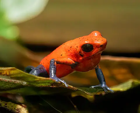
Strawberry poison frog
The strawberry poison frog is a tiny frog of the rainforest floor in Nicaragua, Costa Rica and Panama. Its bright colors warn hunters that its skin is poisonous, and its parents take amazing care of their young: the mother carries each tadpole to its own little pool and feeds it eggs.
-
 Watch
Animal
White-faced capuchin
The white-faced capuchin is a smart, curious monkey from the forests of Central America, with black fur and a cream-white face, throat and shoulders. It eats fruit and hunts insects, lives in close family troops led by an alpha male, and on one island in Panama some capuchins crack open nuts and crabs with stones.
Explore next
-
Watch
Landmark
León Cathedral
León Cathedral stands in the city of León, in Nicaragua. Building began in 1747 and went on into the early 1800s. It was designed by Diego José de Porres Esquivel, an architect from Guatemala, and it mixes Baroque and Neoclassical styles. It became a UNESCO World Heritage Site in 2011.
-
Watch
Natural wonder
Lake Nicaragua
Lake Nicaragua, also called Lake Cocibolca, is the largest freshwater lake in Central America. Its island of Ometepe is made of two volcanoes, and bull sharks are known to travel between the lake and the Caribbean Sea.
-
Watch
Natural wonder
Caribbean Sea
The US National Hurricane Center counts the Caribbean Sea as part of the Atlantic basin. Along the coast of Belize lies the largest barrier reef in the northern hemisphere, UNESCO says. Far below, in the Cayman Trough, the sea floor is slowly spreading apart, and scientists have found hot springs there almost 5,000 meters down.
-
 Watch
 Country
Honduras
Honduras is a mountainous country in Central America, with the Caribbean Sea to the north and a short Pacific coast to the south. Its forests are home to jaguars and macaws, the Maya city of Copán stands in the west, and about 10.2 million people live there (official 2026 estimate).
-
 Watch
 Country
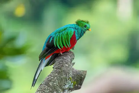
Costa Rica
Costa Rica is a small country in Central America between the Caribbean Sea and the Pacific Ocean. Volcanoes and mountains run down its middle, its forests are full of wildlife, and many national parks protect them. Since 1949 it has had no army. About 5.2 million people lived there in 2025.
-
Watch
3D
Animal
Jaguar
The jaguar is the largest cat in North and South America. It lives near rivers and swamps, swims well, and has such a powerful bite that it can crack a turtle's shell. Most jaguars live in the Amazon rainforest.
-
Watch
Animal
Strawberry poison frog
The strawberry poison frog is a tiny frog of the rainforest floor in Nicaragua, Costa Rica and Panama. Its bright colors warn hunters that its skin is poisonous, and its parents take amazing care of their young: the mother carries each tadpole to its own little pool and feeds it eggs.
-
Watch
Animal
White-faced capuchin
The white-faced capuchin is a smart, curious monkey from the forests of Central America, with black fur and a cream-white face, throat and shoulders. It eats fruit and hunts insects, lives in close family troops led by an alpha male, and on one island in Panama some capuchins crack open nuts and crabs with stones.
For parents & teachers
What children will learn
- Locate Nicaragua and describe its volcanic west, lake basin and Caribbean lowlands.
- Explain why most Nicaraguans live in the west.
- Name some of the peoples and languages of the Caribbean coast.
- Outline Nicaragua's history from Spanish colonization to independence and the founding of Managua as capital.
Recommended ages: 3 to 17 · About 15 minutes
Talk about it
- Why might people choose to live near volcanoes even though they can erupt?
- Why would a country choose a capital between two rival cities?
- What do you think it is like when a country has very different regions, like Nicaragua's west and east?
Try at home or in class
- Fill a baking tray with water and add small clay mounds in a line to make 'volcano islands', like Ometepe in Lake Nicaragua.
- Measure rainfall in a jar outside for a week, then compare it with the Caribbean side's almost 3,810 millimeters a year.
Key vocabulary: volcano, basin, lowlands, mestizo, compromise, watershed
Where these facts come from
- Wikidata , Wikimedia Foundation (CC0 1.0)
- Natural Earth vector data , Natural Earth (NACIS) (Public domain)
- UNESCO World Heritage List , UNESCO World Heritage Centre (Linked as a reference; site facts come from Wikidata)
- Nicaragua (introduction, quick facts, relief, drainage, lakes, soils, climate) , Encyclopaedia Britannica
- Nicaragua: Plant and animal life (people, languages, religion, settlement; early history) , Encyclopaedia Britannica
- Nicaragua: Cultural institutions (sports, media, conquest) , Encyclopaedia Britannica
- Nicaragua: Foreign intervention (1838 to the Somoza era) , Encyclopaedia Britannica
- Nicaragua from 1990 to 2006 , Encyclopaedia Britannica
- León Cathedral , UNESCO World Heritage Centre
- Ruins of León Viejo , UNESCO World Heritage Centre
- PlayOwl region table, version 1 , PlayOwl (PlayOwl original data)
- flag-icons 7.5.0 , Panayiotis Lipiridis and contributors (MIT)
- Wikimedia Commons , Wikimedia Foundation (Per file (public domain, CC0, CC BY or CC BY-SA); see each media record)
Checked, not yet human-reviewed. Last updated November 1, 2026. Spotted a mistake? Tell us.
Picture credits
- Photo: FurlongWiki, CC BY-SA 4.0, via Wikimedia Commons · source · license
- Photo: Guillaume Baviere from Uppsala, Sweden, CC BY-SA 2.0, via Wikimedia Commons · source · license
- Photo: Adam Jones from Kelowna, BC, Canada, CC BY-SA 2.0, via Wikimedia Commons · source · license
- Photo: Thiagomarcelcampi, CC BY-SA 4.0, via Wikimedia Commons · source · license
- Photo: Charles J. Sharp, CC BY-SA 4.0, via Wikimedia Commons · source · license
- Photo: © Frank Schulenburg, CC BY-SA 4.0, via Wikimedia Commons · source · license