 Country
North America
Costa Rica
Costa Rica is a small country with two seas. It has smoking volcanoes and green forests. Bright frogs and colorful birds live there.
Costa Rica is a small country in Central America between the Caribbean Sea and the Pacific Ocean. Volcanoes and mountains run down its middle, its forests are full of wildlife, and many national parks protect them. Since 1949 it has had no army. About 5.2 million people lived there in 2025.
Costa Rica, a Central American republic between Nicaragua and Panama, is built around a volcanic and granite mountain spine whose Valle Central holds more than half the population. Its 1949 constitution abolished the army and gave women the vote, and it is known for a long democratic tradition, high literacy and a strong commitment to conservation, with four UNESCO World Heritage Sites. The World Bank counted 5,152,950 people in 2025.
Photo: Giles Laurent, CC BY-SA 4.0, via Wikimedia Commons
Discover Costa Rica
Costa Rica is a small country.
It has a sea on each side. It has tall volcanoes and green forests. The capital city is San José.
Costa Rica is a small country in Central America. The Caribbean Sea washes its northeast coast and the Pacific Ocean its southwest coast, and at its narrowest point the two are only about 120 kilometers apart. Nicaragua lies to the north and Panama to the southeast.
Mountains and volcanoes run down the middle of the country. The capital, San José, sits in a high valley called the Valle Central, where more than half of all Costa Ricans live. Many people use the phrase pura vida, which means pure life, to say hello or thank you.
Costa Rica stretches northwest to southeast between Nicaragua and Panama, with a Caribbean coastline of about 300 km and a Pacific coastline of about 1,015 km; at its narrowest the two coasts are about 120 km apart. Its heartland is the Valle Central (Meseta Central), an upland basin that has been the center of the country since colonial times, holds more than half the population and is devoted to growing coffee.
Britannica describes it as generally regarded as Central America's most stable and democratic country: the 1949 constitution created a one-house legislature and an independent electoral body, abolished the army and gave women the right to vote, and more than nine-tenths of people can read. Ecotourism and foreign investment shifted the economy from farming to services and technology by the late 20th century. The World Bank counted 5,152,950 people in 2025; Laura Fernández Delgado is president (2026).

Cities and famous places
San José is the biggest city.
It has a beautiful old theater. Long ago, people carved giant stone balls. You can still see them today.
San José, the capital, stands in the Valle Central at about 1,160 meters above sea level, so it is mild, around 21 °C on average. Its most famous building is the National Theatre, dating from 1897, with marble staircases and a painted ceiling. Under the Plaza of Culture, a museum shows gold objects made long ago.
In the south, near the Diquís River delta, people living in chiefdoms between the years 500 and 1500 carved huge stone spheres, some up to 2.57 meters across. UNESCO made four of their villages a World Heritage Site in 2014. Far out in the Pacific, about 530 kilometers away, lies Cocos Island, another World Heritage Site.
San José lies in the Valle Central at 1,160 m, with a mean temperature of 21 °C and more than 1,800 mm of rain a year. Most cultural institutions are there: the Renaissance-style National Theatre (1897) on the Plaza of Culture, with a ceiling fresco and murals of Costa Rican life; the Pre-Columbian Gold Museum beneath the plaza; and the National Museum, with the largest collection of pre-Columbian art. Many of Cartago's older buildings were destroyed by earthquakes.
UNESCO inscribed the precolumbian chiefdom settlements with stone spheres of the Diquís in 2014: four sites (Finca 6, Batambal, El Silencio and Grijalba-2) with mounds, paved areas, burials and spheres up to 2.57 m in diameter still in their original places, from chiefdoms of 500–1500 CE. Cocos Island National Park (1997), 530 km offshore, protects 202,100 ha, including the most diverse coral reefs of the Eastern Tropical Pacific.
Volcanoes, forests and two coasts
Costa Rica has many volcanoes.
Some have roads right up to the top. Thick green forests cover lots of the land. The Caribbean side gets rain almost all year.
Two mountain chains run down Costa Rica. The northern one is full of volcanoes, such as Irazú and Poás, which have paved roads up to their active craters, and Arenal, the country's youngest cone-shaped volcano. The southern chain, the Talamanca range, is made of granite, and it holds the highest mountain, Cerro Chirripó, at 3,819 meters.
Thick evergreen forest covers about one-third of the country. On the Caribbean side, trade winds bring rain all year. On the Pacific side there is a wet season and a dry season, and the northwest has dry forest. Earthquakes are a danger in most of the country.
Two chains form Costa Rica's spine: the volcanically active Cordillera Volcánica in the north (the Guanacaste, Tilarán and Central ranges) and the Cordillera de Talamanca in the south, a massive granite batholith. Irazú (3,432 m) and Poás (2,704 m) have paved roads to their active craters and, with earthquakes, are serious hazards for the Valle Central; Arenal, the youngest stratovolcano, erupted in 1968. Cerro Chirripó, 3,819 m, is the highest point in Costa Rica and in southern Central America; UNESCO notes glacial cirques and lakes on the Talamanca range, found nowhere else in the region.
Caribbean trade winds bring year-round rain, while the Pacific side has a wet season (about May to October in the north, April to December in the south). Broad-leaved evergreen forest covers about one-third of the land. The Área de Conservación Guanacaste (UNESCO, 1999), 147,000 ha, runs about 100 km from the Pacific to Caribbean-basin rainforest and protects the best dry forest from Central America to northern Mexico.

Animals of Costa Rica
Costa Rica has bright red-eyed frogs.
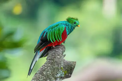
A green and red bird called the quetzal lives in its mountain forests. Jaguars, monkeys and sloths live there too. Caimans rest by the rivers.
Costa Rica's animals come from two continents. Monkeys, anteaters and sloths came from South America, and deer, wild cats, otters, coyotes and foxes came from North America. Tropical birds, snakes, iguanas and frogs are common.
In the Talamanca mountains, about 600 kinds of birds have been recorded, including the shining green resplendent quetzal, and all the wild cats of Central America live there. In the dry northwest, the Guanacaste conservation area protects jaguars, ocelots, tapirs, at least 40 kinds of bats, American crocodiles and spectacled caimans.
Britannica notes that Costa Rica's abundant mammals have major ties to both continents: monkeys, anteaters and sloths are South American in origin, while deer, wild cats, weasels, otters, coyotes and foxes are North American. Its many life zones have long drawn tropical biologists, for example to the research stations of the Organization for Tropical Studies.
UNESCO records about 215 mammal and some 600 bird species in the Talamanca–La Amistad property, among them the resplendent quetzal, every cat species of Central America, the endangered ornate spider monkey and Central American tapir, and the vulnerable black-crowned Central American squirrel monkey. The Área de Conservación Guanacaste holds about 7,000 plant and more than 900 vertebrate species, including jaguar, margay, jaguarundi and ocelot, some 500 birds such as the endangered great green macaw, and the American crocodile and spectacled caiman. Around Cocos Island, UNESCO highlights large ocean predators such as the endangered scalloped hammerhead shark.
People, languages and ways of life
About 5.2 million people live in Costa Rica.
Most people speak Spanish. Farmers grow coffee, bananas and pineapples. Painted oxcarts are a famous folk art.
About 5.2 million people lived in Costa Rica in 2025, and Spanish is the official language. More than half live in the Valle Central. Most people have European ancestors, and many others have mixed Indigenous and European ancestors. In Limón province on the Caribbean coast, many people descend from workers from the West Indies, mostly Jamaica, who came to build a railroad. Indigenous peoples such as the Bribrí and Cabécar live in the Talamanca mountains.
Coffee has been grown in the Valle Central since the 1800s, and bananas and pineapples are grown for export too. Costa Rica is famous for its brightly decorated oxcarts and wood carvings.
Britannica describes a population nearly four-fifths of European descent, with mestizos close to one-fifth. Guanacaste, once part of Nicaragua, blends Spanish, Indigenous and African heritage. Afro-Costa Ricans in Limón descend largely from West Indian, mainly Jamaican, workers brought in the 19th century to build the Atlantic Railroad and work on banana plantations; residence laws long confined them to the Caribbean coast, until in 1949 the government let them travel freely and become citizens. Indigenous peoples include the Bribrí and Cabécar in the Talamanca, the Boruca and Térraba near the Valle del General and the Guatuso in the north.
Spanish is official. Slightly less than three-fourths of people are Roman Catholic, the official religion, though the constitution guarantees freedom of religion. Education is free and compulsory, and about one-fourth of the national budget goes to it. Coffee from small family farms shaped settlement of the Valle Central in the 19th century; Britannica names bananas as the principal export, and by the late 20th century pineapples had passed coffee for second place.
From stone spheres to a land without an army
Long ago, people carved giant stone balls here.
Later, Spain ruled the land. In 1821, Costa Rica was free from Spain. Today it has no army.
Indigenous chiefdoms lived in Costa Rica long before Europeans arrived, and between the years 500 and 1500 people in the south carved huge stone spheres. Spain later ruled the land, and settlers made the Valle Central, around Cartago and San José, the heart of the colony.
In 1821 Costa Rica, with the rest of Central America, left Spanish rule. From the 1840s, oxcarts carried Costa Rican coffee to ports for ships bound for Europe. In 1889 Costa Rica held what is called the first fully free and fair election in Central America. A new constitution in 1949 got rid of the army and gave women the right to vote.
Britannica estimates that about 400,000 Indigenous people lived in what is now Costa Rica before the Spanish conquest, a number drastically reduced by conquest, disease and slave raids; the Diquís chiefdoms (500–1500 CE) left their stone spheres. Under Spain the Valle Central, around Cartago and San José, became the colony's heartland. In 1821 Costa Rica joined the short-lived Mexican Empire with the rest of Central America, in 1823 helped found the United Provinces of Central America, and left the federation in 1838. Coffee exports from the 1840s brought British investment; Guanacaste left Nicaragua for Costa Rica in 1825.
The 1871 constitution lasted, with a brief break, until 1949, and the 1889 election is considered the first entirely free and honest one in Central America. Railways and bananas grew under Minor C. Keith, whose interests joined the United Fruit Company in 1899. After a disputed election, a brief civil war in 1948 brought José Figueres Ferrer to power; the 1949 constitution banned an army, established women's suffrage and abolished institutionalized racism, and the government was handed to the elected president, Otilio Ulate. In 1987 President Óscar Arias Sánchez received the Nobel Peace Prize for his work for lasting peace in Central America.
Costa Rica on the map
Find Costa Rica on the globe.
It is in Central America. One sea is on one side, and a big ocean is on the other side.
Costa Rica sits in Central America, between North and South America. Nicaragua lies to the north and Panama to the southeast. The Caribbean Sea is on its northeast side, and the Pacific Ocean is on its long southwest side.
The Pacific coast is more than three times as long as the Caribbean coast. Cocos Island, about 530 kilometers out in the Pacific, belongs to Costa Rica too.
Costa Rica is bounded by Nicaragua to the north, the Caribbean Sea along its roughly 300-km northeastern coast, Panama to the southeast and the Pacific Ocean along its roughly 1,015-km southwestern coast. The continental divide splits the Valle Central: the Reventazón drains its eastern part to the Caribbean and the Grande de Tárcoles its western part to the Pacific.
The Caribbean lowlands make up about one-fifth of the country, the Pacific lowlands about one-tenth. The Talamanca range continues across the border into Panama, where the two countries share the La Amistad World Heritage property. Cocos Island lies about 530 km offshore in the Eastern Tropical Pacific.
- Caribbean coastline
- about 300 km
- Pacific coastline
- about 1,015 km
- Highest point
- Cerro Chirripó, 3,819 m
- People (2025)
- 5,152,950
Amazing facts
-
Costa Rica has no army.
Costa Rica's constitution of 1949 abolished the army.
The 1949 constitution prohibited establishing or maintaining an army, established women's suffrage and abolished institutionalized racism.
-
Some old stone balls in Costa Rica are taller than a grown-up.
The stone spheres of the Diquís can be up to 2.57 meters across.
UNESCO describes Diquís stone spheres up to 2.57 m in diameter, many still in their original positions within chiefdom settlements of 500–1500 CE.
-
People in Costa Rica say pura vida.
Many Costa Ricans say pura vida, meaning pure life, as a greeting or to say thanks.
The phrase pura vida, pure life, is used in everyday speech as a greeting or to show appreciation.
-
You can drive up to the top of some volcanoes in Costa Rica.
Irazú and Poás volcanoes have paved roads that reach the rims of their active craters.
Two of the highest peaks of the Cordillera Volcánica, Irazú (3,432 m) and Poás (2,704 m), have paved roads to the rims of their active craters.
-
Cocos Island is far out in the ocean.
Cocos Island lies about 530 kilometers off the coast and has the only humid tropical forest on an ocean island in the eastern tropical Pacific.
UNESCO says Isla del Coco supports the only humid tropical forest on an oceanic island in the Eastern Tropical Pacific, and its waters hold the region's most diverse coral reefs.
Words to know
- volcano
- an opening in Earth's crust where melted rock, ash and gas come out
- crater
- a bowl-shaped hole at the top of a volcano
- chiefdom
- a community or group of villages led by a chief
- constitution
- a country's most important set of laws, describing how it is governed
- dry forest
- a tropical forest with a long dry season, where many trees lose their leaves
- World Heritage Site
- a place UNESCO lists as important to all people, to be protected
Discovery challenge
-
Which two waters are on each side of Costa Rica?
Costa Rica lies between which two bodies of water?
Which two bodies of water border Costa Rica's northeastern and southwestern coasts?
- The Caribbean Sea and the Pacific Ocean
- The Red Sea and the Indian Ocean
- The North Sea and the Arctic Ocean
Show the answer
The Caribbean Sea and the Pacific Ocean
The Caribbean Sea is on one side and the Pacific Ocean on the other.
The Caribbean Sea washes the northeast coast and the Pacific Ocean the southwest coast.
The Caribbean coast runs about 300 km and the Pacific coast about 1,015 km.
-
What does Costa Rica not have?
What did Costa Rica's 1949 constitution abolish?
Besides giving women the vote, what did the 1949 constitution prohibit?
- Schools
- An army
- Elections
Show the answer
An army
Costa Rica has no army.
The 1949 constitution got rid of the army and gave women the right to vote.
It prohibited establishing or maintaining an army and strengthened the electoral tribunal.
-
Which bright bird lives in Costa Rica's mountain forests?
Which shining green and red bird lives in the Talamanca mountains?
Which bird does UNESCO name among some 600 species in Talamanca–La Amistad?
- Penguin
- Resplendent quetzal
- Ostrich
Show the answer
Resplendent quetzal
The quetzal is green and red.
The resplendent quetzal lives in Costa Rica's mountain forests.
UNESCO lists the resplendent quetzal among about 600 bird species there.
-
What did people long ago carve in Costa Rica?
What did chiefdoms in southern Costa Rica carve between the years 500 and 1500?
Which objects, up to 2.57 m across, make the Diquís sites a World Heritage Site?
- Stone spheres
- Ice sculptures
- Wooden ships
Show the answer
Stone spheres
They carved big stone balls.
They carved huge stone spheres, some up to 2.57 meters across.
UNESCO inscribed four Diquís settlement sites with their stone spheres in 2014.
-
What is the capital city of Costa Rica?
Which city in the Valle Central is the capital of Costa Rica?
Which capital, at 1,160 m in the Valle Central, is home to the National Theatre (1897)?
- Panama City
- San José
- Managua
Show the answer
San José
San José is the capital.
San José is the capital, in the Valle Central.
San José, at 1,160 m, holds the National Theatre and most cultural institutions.
Animals of Costa Rica
-
Watch
Animal
Resplendent quetzal
The resplendent quetzal is a glittering green and red bird of the cloud forests of southern Mexico and Central America. Males grow long, flowing plumes, up to about 90 centimeters. Quetzals eat mostly small fruits related to avocados, and the bird is the national emblem of Guatemala.
-
Watch
Animal
Red-eyed tree frog
The red-eyed tree frog lives in the rainforests of Central America. By day it sleeps folded up on a leaf, looking plain green. When something disturbs it, it flashes huge red eyes, orange feet and blue-and-yellow sides.
-
 Watch
3D
Animal
Jaguar
The jaguar is the largest cat in North and South America. It lives near rivers and swamps, swims well, and has such a powerful bite that it can crack a turtle's shell. Most jaguars live in the Amazon rainforest.
-
 Watch
Animal
Brown-throated sloth
The brown-throated sloth is a three-toed sloth of the rainforests of Central and South America. It eats leaves, saves energy by moving very slowly, and its shaggy fur can turn green with tiny algae that grow in it.
-
 Watch
Animal
Army ant
Army ants hunt together in giant swarms and never build a permanent nest. This page is about the best-studied kind, Eciton burchellii, of Central and South American forests. Each night of its traveling phase the colony moves, and the workers link their legs to build a living camp around their queen and young.
-
 Watch
Animal
Common blue morpho
The common blue morpho is a large butterfly of the forests of Mexico, Central America and South America. The tops of its wings flash bright blue, but the undersides are brown with big eyespots, which camouflage it when it lands with its wings closed. Adults sip juice from rotting fruit instead of nectar.
-
 Watch
Animal
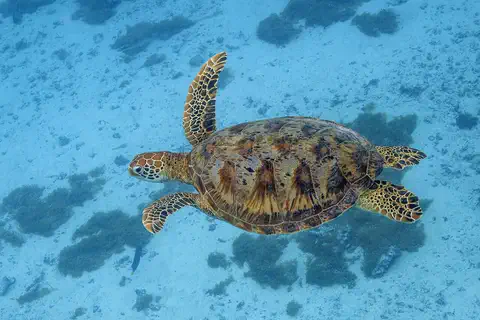
Green sea turtle
The green sea turtle is the largest sea turtle with a hard shell. It lives in warm seas around the world and, unlike other sea turtles, grown-ups eat mostly seagrass and algae. Females swim hundreds or even thousands of kilometers to lay their eggs on the beaches where they hatched long ago.
-
 Watch
Animal
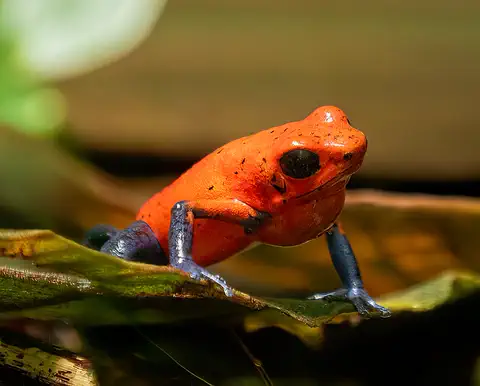
Strawberry poison frog
The strawberry poison frog is a tiny frog of the rainforest floor in Nicaragua, Costa Rica and Panama. Its bright colors warn hunters that its skin is poisonous, and its parents take amazing care of their young: the mother carries each tadpole to its own little pool and feeds it eggs.
-
 Watch
Animal
Common basilisk
The common basilisk is a lizard of riversides and streams from Nicaragua to Venezuela. It climbs trees, swims well and, when it is startled, can sprint upright across the surface of the water on its big back feet before it sinks and swims.
-
 Watch
Animal
Leafcutter ant
Leafcutter ants are farmers. Workers cut pieces of leaves, carry them home along busy trails and use them to grow a fungus garden underground, and the fungus is their food. This page is about one well-known kind, Atta cephalotes, which lives in Central and South America in giant nests of hundreds of thousands to millions of ants.
-
 Watch
Animal
Hercules beetle
The Hercules beetle is one of the largest beetles in the world: the biggest males can reach 18 centimeters, horns included. It lives in rainforests from southern Mexico to Bolivia and on a few Caribbean islands. Its huge grubs spend more than a year eating rotting wood before they turn into beetles.
-
 Watch
Animal
Glasswing butterfly
The glasswing butterfly has wings you can see right through, framed with orange-brown edges. It lives from Mexico to Panama, and its caterpillars eat plants called Cestrum. Scientists study its clear wings because they hardly reflect any light, which could help people design better glass.
Explore next
-
 Watch
 Country
Panama
Panama is a narrow country in Central America that joins North and South America. Since 1914 the Panama Canal has let ships cross from the Atlantic Ocean to the Pacific without sailing around South America. Panama has rainforests, more than 1,600 islands and about 4.6 million people (2025).
-
Watch
Animal
Resplendent quetzal
The resplendent quetzal is a glittering green and red bird of the cloud forests of southern Mexico and Central America. Males grow long, flowing plumes, up to about 90 centimeters. Quetzals eat mostly small fruits related to avocados, and the bird is the national emblem of Guatemala.
-
Watch
Animal
Red-eyed tree frog
The red-eyed tree frog lives in the rainforests of Central America. By day it sleeps folded up on a leaf, looking plain green. When something disturbs it, it flashes huge red eyes, orange feet and blue-and-yellow sides.
-
Watch
3D
Animal
Jaguar
The jaguar is the largest cat in North and South America. It lives near rivers and swamps, swims well, and has such a powerful bite that it can crack a turtle's shell. Most jaguars live in the Amazon rainforest.
-
Watch
Animal
Brown-throated sloth
The brown-throated sloth is a three-toed sloth of the rainforests of Central and South America. It eats leaves, saves energy by moving very slowly, and its shaggy fur can turn green with tiny algae that grow in it.
- Watch Geography Types of volcanoes Volcanoes come in different shapes. Runny lava builds wide, gentle shield volcanoes like Mauna Loa. Sticky lava and ash build tall, steep stratovolcanoes like Mount Fuji. Small cinder cones grow from bits of lava thrown into the air. Whether lava is runny or sticky, and how much gas it holds, decides the shape and how explosive the eruptions are.
-
Watch
Animal
Army ant
Army ants hunt together in giant swarms and never build a permanent nest. This page is about the best-studied kind, Eciton burchellii, of Central and South American forests. Each night of its traveling phase the colony moves, and the workers link their legs to build a living camp around their queen and young.
-
Watch
Animal
Common blue morpho
The common blue morpho is a large butterfly of the forests of Mexico, Central America and South America. The tops of its wings flash bright blue, but the undersides are brown with big eyespots, which camouflage it when it lands with its wings closed. Adults sip juice from rotting fruit instead of nectar.
For parents & teachers
What children will learn
- Locate Costa Rica between Nicaragua and Panama, the Caribbean Sea and the Pacific Ocean.
- Describe how Costa Rica's volcanic mountains and two coasts shape its climate and forests.
- Explain why animals from both North and South America live in Costa Rica.
- Outline Costa Rica's history from the Diquís chiefdoms to the 1949 constitution.
Recommended ages: 3 to 17 · About 15 minutes
Talk about it
- Why might a country decide to have no army? What might it spend that money on instead?
- Why do you think more than half of Costa Ricans live in one high valley?
- How do national parks help both animals and the people who visit them?
Try at home or in class
- Shape a volcano from modeling clay and label the crater, then compare it with a photo of Poás or Irazú.
- Roll a ball of clay into a sphere as round as you can, and think about how hard it would be to carve one 2.5 meters wide from stone.
Key vocabulary: volcano, crater, chiefdom, constitution, dry forest, World Heritage Site
Where these facts come from
- Wikidata , Wikimedia Foundation (CC0 1.0)
- Natural Earth vector data , Natural Earth (NACIS) (Public domain)
- UNESCO World Heritage List , UNESCO World Heritage Centre (Linked as a reference; site facts come from Wikidata)
- Costa Rica (introduction, quick facts, land, relief, climate, plant and animal life) , Encyclopaedia Britannica
- Costa Rica: People (ethnic groups) , Encyclopaedia Britannica
- Costa Rica: Languages (religion, settlement patterns) , Encyclopaedia Britannica
- Costa Rica: Health and welfare (education, cultural life, cultural institutions) , Encyclopaedia Britannica
- Costa Rica: Independence (Costa Rica in the 20th century) , Encyclopaedia Britannica
- Costa Rica: Transition to democracy , Encyclopaedia Britannica
- Talamanca Range-La Amistad Reserves / La Amistad National Park , UNESCO World Heritage Centre
- Area de Conservación Guanacaste , UNESCO World Heritage Centre
- Cocos Island National Park , UNESCO World Heritage Centre
- Precolumbian Chiefdom Settlements with Stone Spheres of the Diquís , UNESCO World Heritage Centre
- Population, total: Costa Rica , World Bank
- Oscar Arias Sánchez: Facts , Nobel Prize Outreach (NobelPrize.org)
- PlayOwl region table, version 1 , PlayOwl (PlayOwl original data)
- flag-icons 7.5.0 , Panayiotis Lipiridis and contributors (MIT)
- Wikimedia Commons , Wikimedia Foundation (Per file (public domain, CC0, CC BY or CC BY-SA); see each media record)
Checked, not yet human-reviewed. Last updated October 27, 2026. Spotted a mistake? Tell us.
Picture credits
- Photo: Giles Laurent, CC BY-SA 4.0, via Wikimedia Commons · source · license
- Photo: Luis Manuel Madrigal Mena, CC BY 2.0, via Wikimedia Commons · source · license
- Photo: Careyjamesbalboa (Carey James Balboa), public domain, via Wikimedia Commons · source
- Photo: Bernard Gagnon, CC0 1.0, via Wikimedia Commons · source · license