How do utility maps show what is underground?
Water, gas, power and phone lines all run under the street. A utility map shows each kind in its own color, so workers know where it is safe to dig.
The big idea: A utility map records every buried pipe and cable as a colored line, one layer for each kind. Before digging, workers check every layer and mark the lines on the ground.
It's like a see-through picture book: each clear page shows one kind of pipe or cable, and when you stack the pages you see everything under the street.
The interactive parts didn't load. The explanations below still work; try reloading the page.
The map of hidden things
- A worker is about to dig a hole for a new street tree. The ground looks empty. But under almost every street there are things you must not hit with a spade.
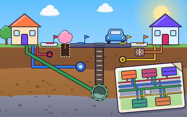
- Here is the street cut open. Water pipes, a big sewer, a gas pipe, electric cables and phone cables all run along it, each at its own depth, with smaller lines branching off to every house.
- A utility map shows the street from above, with every buried line drawn in a color. Blue is drinking water, green is sewer, yellow is gas, red is electricity and orange is phone and internet. Each color is its own layer.
- Maps can be a little bit wrong, so a worker checks with a locator. It senses buried pipes and cables from above. Each line is then marked on the ground with paint and flags in its own color.
- With the marks to guide them, the worker picks a clear spot and digs. The hole stays away from every line, and the tree is planted without breaking anything.
- When a new pipe or cable is laid, it is added to the map straight away. A map only keeps people safe if it shows what is really there.
Look under the street
This street has been sliced open like a cake. Tap each pipe and cable to see what it carries.
- Water main. The water main carries clean drinking water under pressure. A smaller pipe branches off to each house. On maps and on the ground, water is marked in blue.
- Sewer. Used water from sinks, baths and toilets runs down a sloping pipe from each house into the sewer, which carries it away to be cleaned. Sewers are marked in green.
- Gas pipe. The gas pipe brings fuel for stoves and heating. Gas is marked in yellow. It is one of the most important lines to keep away from when digging.
- Electric cable. Thick electric cables carry power under the sidewalk to every building and street lamp. Electricity is marked in red. Never dig near a red mark without checking.
- Phone and internet. Phone and internet cables run inside plastic tubes called ducts, close to the surface. They are marked in orange. One cut cable can leave a whole street with no internet.
- Manhole. A manhole is a shaft with a heavy lid, where workers can climb down to inspect and clean the sewer. The lid in the road is a clue to what lies below.
- Paint marks and flags. Before a dig, each buried line is marked on the ground with paint and flags in its own color: blue for water, green for sewer, yellow for gas, red for electricity, orange for phone.
Layers and a test hole
Switch the map's layers on and off. Drag the white dig box to a spot and dig a test hole. The picture on the right shows the ground under the box.
Experiment: Only the water layer is switched on, and the dig box is not on a blue line. Is it safe to dig there?
- Switch on only the Water layer, then press Move to the next spot.
- The box is not on a blue line. Dig a test hole. What did it find?
- Now switch on every layer, drag the box to a clear spot and dig again.
What we found: A spot that is clear on one layer can have a line on another. The test hole found a gas pipe that only shows on the gas layer. A dig is safe only after every layer has been checked.
Turn on JavaScript to try it yourself.
Plan the digs
Three jobs need a hole: a street tree, a road repair and a mailbox post. For each one, check the layers, drag the dig box to a clear spot inside the white zone and dig.
How utility maps keep diggers safe
Turn on a tap, switch on a light or flush a toilet, and something under the street goes to work. Water pipes, sewers, gas pipes, electric cables and phone cables all run below the road and the sidewalks, with a small branch going to every building. These are called utilities.
Nobody can see them, so they are drawn on a utility map. The map shows the street from above, with a colored line for every pipe and cable. Each kind has its own color and its own layer, a bit like clear pages in a book that can be looked at one at a time or all together.
Before anyone digs, they ask for the map. In many countries there is a free phone number or website for this. Then workers walk over the ground with a locator, a tool that can sense buried lines, and mark each one with paint and little flags in the right color.
Only then does the digging begin, and near a line it is done slowly by hand. The treasure map idea fits well, with one twist: on this map, the marks show where not to dig. And when a new pipe goes in, it is added to the map for the next person.
Key words
- Utility
- A service that reaches buildings through pipes or cables, such as water, sewer, gas, electricity or internet.
- Layer
- One see-through sheet of a map that shows just one kind of thing.
- Main
- A large pipe or cable that runs along the street. Smaller service lines branch from it to each building.
- Locator
- A tool that can sense buried pipes and cables from above the ground.
- Tolerance zone
- The strip of ground close to a marked line, where digging must be slow and careful.
- Excavation
- Digging into the ground, from a small post hole to a long trench.
Check your thinking
-
What does a utility map show?
Show the answer
Where the buried pipes and cables run. A utility map draws every buried pipe and cable as a colored line on a plan of the street.
-
Why must a digger check every layer, not just one?
Show the answer
A spot that is clear on one layer may have a line on another. Each layer shows only one kind of line. A gas pipe will not appear on the water layer.
-
Why are sewers usually the deepest pipes under a street?
Show the answer
The dirty water has to run downhill to flow away. Nothing pushes the water in a sewer along. It simply runs downhill, so the pipe must keep sloping down.
-
The map says a spot is clear. Why do workers still check the ground with a locator?
Show the answer
Maps can be old or a little bit wrong. A line may have been drawn in slightly the wrong place, or laid after the map was made. Checking on site catches that.
-
A cable lies 0.6 m down. A hole 1 m deep is dug half a meter to one side of it, and another 0.4 m deep directly above it. Which statement is right?
Show the answer
Both are close calls: each comes within about half a meter of the cable. Safe distance counts in every direction. One hole is close sideways and the other stops only 0.2 m above the cable.
-
A worker sees yellow paint and yellow flags on the ground. What is buried there?
Show the answer
A gas pipe. Yellow means gas. The colors on the ground match the colors on the map.
You're a Buildings & city systems expert!
You watched, looked inside, tried it, solved the challenge and went deeper. Pick another question below, or switch the age at the top to see this topic another way.
More about buildings & city systems
 #370
Buildings & city systems
How does a stadium open and close its roof?
Coordinate movable roof sections as they travel along their tracks.
#370
Buildings & city systems
How does a stadium open and close its roof?
Coordinate movable roof sections as they travel along their tracks.
 #371
Buildings & city systems
How do buildings use emergency backup power?
Simulate an interruption and watch essential equipment transfer to a backup supply.
#371
Buildings & city systems
How do buildings use emergency backup power?
Simulate an interruption and watch essential equipment transfer to a backup supply.
 #372
Buildings & city systems
How do roofs keep rain out?
Layer materials, add flashing and drainage, and trace raindrops around joints.
#372
Buildings & city systems
How do roofs keep rain out?
Layer materials, add flashing and drainage, and trace raindrops around joints.
 #373
Buildings & city systems
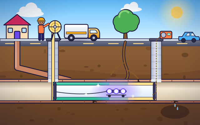
How can underground pipes be repaired without digging up a street?
Insert a virtual lining and watch a repaired passage form inside a damaged pipe.
#373
Buildings & city systems
How can underground pipes be repaired without digging up a street?
Insert a virtual lining and watch a repaired passage form inside a damaged pipe.
Keep exploring
Games to play next
- Route PlannerFind the shortest way around town, dodge closed roads, and measure trips with a scale bar.
- Bridge LabBuild a bridge from beams, brace it with triangles, and stay on budget.
- Area ArchitectDesign rooms that hit the area and perimeter on the blueprint.
Guide for grown-ups
- How to start homeschooling: a step-by-step guide for familiesA guide for parents · 7 min read
Science games by grade
Science worksheets by grade
- Preschool Science Worksheets
- Pre-K Science Worksheets
- Kindergarten Science Worksheets
- 1st Grade Science Worksheets
- 2nd Grade Science Worksheets
- 3rd Grade Science Worksheets
- 4th Grade Science Worksheets
- 5th Grade Science Worksheets
- 6th Grade Science Worksheets
- 7th Grade Science Worksheets
- 8th Grade Science Worksheets