
City Asia
Isfahan
Isfahan is a city in Iran. It has a huge old square with gardens, a long pool and shops all around it.
Isfahan is one of Iran's main cities, in the center of the country. Its great public square, built in the early 1600s, is a UNESCO World Heritage site, with rows of shops in arcades on every side. Iran's 2016 census counted 1,961,260 people in the city.
Isfahan (Esfahan, Ispahan), in central Iran, was the capital of the Safavid dynasty (16th–17th centuries), whose architectural heritage it keeps (Universalis); its public square, Meidan Emam, is on the World Heritage List. Census 2016: 1,961,260.
Photo: Bernard Gagnon, CC BY-SA 4.0, via Wikimedia Commons
Discover Isfahan
Isfahan is a big city in the middle of Iran.
About two million people lived there at the 2016 census.
Universalis says Isfahan is one of Iran's main cities, in the center of the country. Long ago it was the capital of the Safavid rulers, and it still has many of the buildings they left. Today it is a center for industry, for universities and for visitors who come to see its history and art.
Iran's census of 24 September 2016 counted 1,961,260 people in the city.
Universalis: Isfahan (Iṣfahān or Eṣfahān), one of Iran's main cities (1,961,260 at the 2016 census), in the center of the country; capital of the Persian Empire under the Safavid dynasty (16th–17th centuries), whose rich architectural heritage it keeps; a major center of industry, higher education and cultural tourism. Statistical Centre of Iran via City Population: Eṣfahān city, census 24 September 2016: 1,961,260 (2006: 1,689,392; 2011: 1,853,293).
- Country
- Iran (in the center of the country)
- People in the city (census, 24 September 2016)
- 1,961,260
- Known for
- industry, universities and colleges, and visitors who come for its history and art (Universalis)
- World Heritage
- the city's great square, listed by UNESCO as 'Meidan Emam, Esfahan' (UNESCO)
The great square
In this photo, a long pool and green gardens fill a huge square. Rows of arches with shops go all around it. A tiled dome stands on one side.
This photo shows Naqsh-e Jahan Square in Isfahan from above on 29 October 2016. A long pool and gardens with clipped trees fill the middle, and two-story arcades run along the sides, with a tiled dome at the left and a tall gateway with two minarets at the right.
UNESCO says the square is 560 meters long and 160 meters wide, covering almost 9 hectares, and calls it one of the largest city squares in the world. Its other name, Naghsh-e Jahan, means 'Image of the World'.
Commons: 'Naqsh-e Jahan Square, Isfahan, Iran', own work by Bernard Gagnon (uploader Bgag, his account), GFDL and CC BY-SA 4.0, taken 29 October 2016; camera location 32.6572 N, 51.6768 E, heading southeast.
UNESCO: a public urban square in the center of Esfahan, one of the largest city squares in the world; 560 m by 160 m, almost 9 ha (another Universalis article gives 512 m by 159 m); also known as Naghsh-e Jahan ('Image of the World'); bordered by two-story arcades and anchored on its four sides by the Sheikh Lotfallah Mosque (east), the pavilion of Ali Qapu (west), the portico of Qeyssariyeh (north) and the Royal Mosque (south); the elements around it are decorated with enameled ceramic tiles and paintings, mostly of flowers, trees and vases.
- Photo
- Naqsh-e Jahan Square from above, 29 October 2016, by Bernard Gagnon
- Size
- 560 m long and 160 m wide, almost 9 hectares (UNESCO)
- Other name
- Naghsh-e Jahan, 'Image of the World' (UNESCO)
A square at the heart of a capital
About 400 years ago, a ruler of Persia built this square at the heart of his capital. People walked there, played polo and shopped under the arches.
UNESCO says the Safavid ruler Shah Abbas I built the square in the early 1600s, at the heart of his capital. People strolled there, held celebrations and played polo on its sandy ground, and the arcades on every side held hundreds of shops. Above one gateway, musicians played public concerts from a balcony.
The square was later paved with stone. A pond was placed in the middle, and lawns were added in the 1990s.
UNESCO: built by the Safavid shah Abbas I in the early 17th century; the heart of the Safavid capital; a homogeneous ensemble built over a short time to one plan; its sandy esplanade was used for promenades, celebrations and polo; the arcades housed hundreds of shops; above the portico of the Qeyssariyeh bazaar a balcony held musicians giving public concerts; the surface, once sand, is now paved with stone; a pond was placed at the center and lawns installed in the 1990s. Universalis: the two well-known bridges over the Zāyandèroud were built at the beginning and in the middle of the 17th century; the city's present age has respected the setting of Safavid Isfahan.
- Early 17th century
- the square was built by the Safavid shah Abbas I (UNESCO)
- Old uses
- walks, celebrations, polo matches, and hundreds of shops in the arcades (UNESCO)
- 1990s
- the sandy square had been paved with stone; a pond was placed in the middle and lawns were added in the 1990s (UNESCO)
River, bridges and bazaar
A river flows past Isfahan, and old bridges cross it. Near the square, a market called a bazaar stretches for 2 kilometers.
Universalis says Isfahan grew up at the edge of a mountain range, where the Zayandeh River comes down. Through a very old network of channels, the river's water reaches a fertile area dotted with villages. Two well-known bridges cross the river; they were built in the 1600s.
UNESCO says the city lies on the main routes that cross central Iran from north to south and from east to west. From the north side of the square, a gateway leads into the Esfahan Bazaar, 2 kilometers long.
Universalis: like all the large Iranian cities, Isfahan developed at the edge of a mountain massif, from which the Zāyandèroud descends; 'the river that gives life' irrigates, through a complex and very ancient network of channels, a fertile territory dotted with large villages; the two famous bridges over the Zāyandèroud, including the Pol-e Khādjou, date from the beginning and the middle of the 17th century. UNESCO: on the main north-south and east-west routes crossing central Iran; the portico of Qeyssariyeh leads to the 2-km-long Esfahan Bazaar. Wikidata: Khaju Bridge (Q1740490) 1.94 km SSE of the city point; Isfahan Grand Bazaar (Q2754230) 0.91 km N.
- River
- the Zāyandèroud (Zayandeh River), whose water reaches a fertile area through a very old network of channels (Universalis)
- Crossroads
- on the main north-south and east-west routes across central Iran (UNESCO)
- Bazaar
- the portico of Qeyssariyeh leads into the Esfahan Bazaar, 2 km long (UNESCO)
Dry, with hot summers
Isfahan is very dry. Summers are hot, and on average winter nights are below freezing.
The World Meteorological Organization's averages for Isfahan, from 1961 to 1990, show hot summers and cold winter nights: the average daily high is 36.4 °C in July, and the average low is −2.4 °C in January.
Very little rain falls. The twelve months add up to only about 112.5 millimeters, and from June to September there is almost none: 1.5 millimeters in all.
WMO World Weather Information Service, Esfahan (Islamic Republic of Iran Meteorological Organization; period 1961–1990 as given in the data): mean daily maximum 8.8 °C (Jan) to 36.4 °C (Jul); mean daily minimum −2.4 °C (Jan) to 21.5 °C (Jul); below freezing in January, February (−0.2) and December (−0.9). Precipitation 0.0 mm (Sep) to 19.6 mm (Dec); June 0.6, July 0.7, August 0.2; sum of the months 112.5 mm. Mean days with at least 1 mm: 0.0 (Sep) to 4.0 (Jan).
- Average daily highs (WMO, Esfahan, 1961–1990)
- 8.8 °C (January) to 36.4 °C (July)
- Average daily lows (same table)
- −2.4 °C (January) to 21.5 °C (July)
- Rain and snow in a year (twelve months added up)
- about 112.5 mm
Shops, tiles and craft
Around Isfahan's square are rows of shops under arches. The buildings are decorated with tiles and with paintings of flowers and trees.
UNESCO says every building around the square, even the arcades of shops, is decorated with enameled ceramic tiles and paintings, mostly of flowering trees, vases and bouquets.
On the west side stands the pavilion of Ali Qapu. Its high portal, 48 meters tall, carries a covered terrace whose roof rests on 18 thin wooden columns. Universalis says Isfahan today is also a center for industry and higher education.
UNESCO: all the architectural elements around the square, including the arcades of shops, are adorned with enameled ceramic tiles and paintings, where floral ornament dominates (flowering trees, vases, bouquets), alongside figurative scenes in the style of Riza-i Abbasi, head of Isfahan's school of painting; the pavilion of Ali Qapu has apartments decorated with paintings and a high portal (48 m) topped by a terrace (tâlâr) with a roof on 18 thin wooden columns. Universalis: a major center of industry, higher education and cultural tourism.
- Arcades
- two-story arcades of shops line the square (UNESCO)
- Decoration
- enameled ceramic tiles and paintings, mostly of flowering trees, vases and bouquets (UNESCO)
- Ali Qapu
- a pavilion with a high portal, 48 m, and a covered terrace on 18 thin wooden columns (UNESCO)
Isfahan on the map
Find Iran on the globe. Isfahan is near its middle.
Isfahan lies at about 32.7° north and 51.7° east, in the center of Iran.
Measured from the city's center point on Wikidata, Naqsh-e Jahan Square is about 0.7 kilometer north-northeast, the Isfahan Grand Bazaar about 0.9 kilometer north and the Khaju Bridge about 1.9 kilometers south-southeast.
Isfahan lies at about 32.65° N and 51.67° E (Wikidata point Q42053; the Natural Earth/sheet point is 5.92 km NNE of it). From the Wikidata point: Naqsh-e Jahan Square (Q4519) 0.68 km NNE; Isfahan Grand Bazaar (Q2754230) 0.91 km N; Khaju Bridge (Q1740490) 1.94 km SSE.
- Latitude
- about 32.7° north
- Longitude
- about 51.7° east
- Place in Iran
- in the center of the country (Universalis)
Amazing facts
-
One name for Isfahan's square means 'Image of the World'!
UNESCO says Isfahan's great square is also known as Naghsh-e Jahan, which means 'Image of the World'.
UNESCO: Meidan Emam is also known as Naghsh-e Jahan ('Image of the World').
-
Long ago, people played polo in Isfahan's square!
UNESCO says the square's sandy ground was once used for polo, walks and celebrations.
UNESCO: the sandy esplanade was used for promenades, celebrations and polo; the surface is now paved with stone.
-
In Isfahan, September gets no rain at all on average!
In the World Meteorological Organization's averages, Isfahan's September rain is 0.0 millimeters.
WMO normals for Esfahan (1961–1990): September 0.0 mm, 0.0 days with at least 1 mm.
Words to know
- arcade
- a row of arches with a covered walkway behind them
- bazaar
- a market with many shops, often under a roof
- pavilion
- a building that stands by a garden or square, often with an open terrace
- polo
- a game played on horseback, hitting a ball with long mallets
- World Heritage site
- a place UNESCO lists as important for everyone in the world
- census
- an official count of all the people in a country
Discovery challenge
-
Isfahan is a city in which country?
Isfahan is one of the main cities of which country?
Isfahan was the Safavid capital in which present-day country?
- Iran
- India
- Italy
Show the answer
Iran
Iran!
Iran.
Iran.
-
What did people play long ago in Isfahan's square?
UNESCO says which game was once played on the square's sandy ground?
Besides promenades and celebrations, UNESCO says the esplanade was used for which game?
- Polo
- Tennis
- Golf
Show the answer
Polo
Polo!
Polo, a game played on horseback.
Polo.
-
How long is Isfahan's great square?
UNESCO says the square is how many meters long?
UNESCO gives the square's length as how many meters (with a width of 160 m)?
- 560 meters
- 56 meters
- 5,600 meters
Show the answer
560 meters
560 meters!
560 meters.
560 m (almost 9 ha in all).
-
What does one name for the square mean?
The square's other name, Naghsh-e Jahan, means what?
UNESCO translates Naghsh-e Jahan as what?
- Image of the World
- Garden of Water
- Road of Kings
Show the answer
Image of the World
Image of the World!
'Image of the World'.
'Image of the World'.
-
Is Isfahan rainy or dry?
In the World Meteorological Organization's averages, about how much rain does Isfahan get in a year?
WMO normals for Esfahan (1961–1990): what is the sum of the twelve monthly precipitation figures?
- About 112.5 mm: very dry
- About 1,125 mm: rainy
- About 2,500 mm: very wet
Show the answer
About 112.5 mm: very dry
Very dry!
About 112.5 millimeters.
112.5 mm.
Nearby places
-
 Watch
Landmark
Naqsh-e Jahan Square
Naqsh-e Jahan Square in Isfahan, Iran, was built by Shah Abbas I of the Safavid dynasty in the early 1600s. It is 560 meters long and 160 meters wide, with shops in two-story arcades and a grand building on each side. UNESCO listed it as a World Heritage Site in 1979.
-
 Watch
Landmark
Persepolis
Persepolis was a royal city of the Persian kings. King Darius I began it around 518 BCE on a huge terrace at the foot of a mountain in southwestern Iran. Its palaces had very tall, slender columns and walls carved with long parades of people bringing gifts. It is a UNESCO World Heritage Site.
-
 Watch
Landmark
Susa
Susa, in southwest Iran, is one of the most ancient places where towns first grew. People built there from more than 6,000 years ago until about 800 years ago, one town on top of another. It was the capital of the Elamites and later of the Persian king Darius I, whose great palace still lies in ruins there.
-
 Watch
City
Tehran
Tehran, the capital of Iran, spreads up the slopes of the Alborz Mountains, with snowy peaks to the north and desert to the south. Once a small village, and later a market town known for its pomegranates, it became the capital in 1786. Today it is a huge, modern city with an old roofed bazaar, a palace that is a World Heritage Site and the 435-meter Milad Tower.
-
 Watch
City
Karaj
Karaj is a big city in Iran, 36 kilometers west of Tehran, on the southern slopes of the Alborz Mountains. It is the main city of Alborz Province. The 2016 census counted 1,592,492 people in Karaj, and Store norske leksikon calls it the fourth largest city in the country.
-
 Watch
Landmark
Behistun Inscription
The Behistun Inscription is a huge carving on a limestone cliff in western Iran, made for the Persian king Darius I around 520 BC. It tells the same story in three languages, all written in cuneiform, and when scholars read it in the 1800s, it unlocked cuneiform writing much as the Rosetta Stone unlocked Egyptian hieroglyphs.
-
 Watch
City
Kuwait City
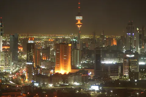
Kuwait City is the capital of Kuwait. It began as a town on the coast early in the 1700s and grew rich from caravans and pearl fishing. Today tall towers rise over the city, and summer days average highs near 47 °C.
-
 Watch
Landmark
Ur
Ur was a great city of Sumer, in the south of what is now Iraq, founded more than 5,000 years ago. Twice it was the capital of an empire. Archaeologists found royal tombs full of gold treasures, streets of brick houses and a huge stepped temple tower called a ziggurat. When the Euphrates River moved away, the fields dried up and the city was abandoned.
Explore next
-
Watch
 Country
Iran
Iran is a country in southwestern Asia. A high, dry plateau fills its middle, with mountain ranges all around it, and about 92 million people (2025) live there. Long ago it was called Persia, and its capital today is Tehran.
-
Watch
City
Tehran
Tehran, the capital of Iran, spreads up the slopes of the Alborz Mountains, with snowy peaks to the north and desert to the south. Once a small village, and later a market town known for its pomegranates, it became the capital in 1786. Today it is a huge, modern city with an old roofed bazaar, a palace that is a World Heritage Site and the 435-meter Milad Tower.
-
 Watch
City
Tabriz
Tabriz is a large city in northwestern Iran and the capital of East Azerbaijan province. Its historic bazaar, a market of covered brick halls and lanes, was one of the most important trading centers on the Silk Road, UNESCO says. The 2016 census counted 1,558,693 people.
-
 Watch
City
Abu Dhabi
Abu Dhabi is the capital of the United Arab Emirates. It began in the 1700s as a small settlement around fresh water on an island, guarded by a coral-stone watchtower. Before oil, it relied on fishing and pearl diving; since the 1960s, money from oil has turned it into a city of towers. An official estimate gave the city about 1.75 million people in 2023.
-
 Watch
City
Almaty
Almaty is the main city of Kazakhstan, in the southeast of the country at the foot of the Ala-Tau mountains. It was founded in 1854 where a Kazakh village called Almaty, 'village of apple trees', stood. It was the capital until 1998, and about 2,387,900 people lived there on 1 September 2026.
-
 Watch
City
Amman
Amman is the capital of Jordan, built on steep hills around a valley high on a plateau. Long ago it was a Roman city called Philadelphia, and its Roman theater, carved into a hillside, still holds about 6,000 people. Today the city spreads across the hills, with houses faced in pale stone. About 4.6 million people lived in Amman Governorate at the end of 2021.
-
 Watch
City
Ankara
Ankara is the capital of Türkiye, in the interior of Anatolia, about 200 kilometers from the Black Sea. People have lived here since the Stone Age, and Romans, Byzantines, Seljuks and Ottomans all left buildings behind. It became the capital in 1923, and today it is a city of government, universities and museums.
-
 Watch
City
Ashgabat
Ashgabat is the capital of Turkmenistan, in Central Asia. It lies at the foot of the Kopet Dag mountains, with the Karakum Desert to the north. The 2022 census counted 1,030,063 people, and Guinness World Records lists the city for its many white marble buildings.
For parents & teachers
What children will learn
- Locate Isfahan in the center of Iran.
- Describe how a public square can be the heart of a city.
- Explain how old channels can bring a river's water to fields in a dry place.
- Read a climate table for a dry place with hot summers and cold winter nights.
Recommended ages: 3 to 17 · About 15 minutes
Talk about it
- What do people do in a big public square today? What did they do long ago in Isfahan?
- Why might a city in a dry land grow up beside a river?
- Why might shops be built under arches around a square?
Try at home or in class
- Square plan: draw Isfahan's square to scale (560 m × 160 m) on squared paper, 1 square = 20 m.
- Tile design: design a tile pattern of flowers and trees, like the ones UNESCO describes.
- Rain compare: Isfahan gets about 112.5 mm of rain a year. Find your town's yearly rain and compare.
Key vocabulary: arcade, bazaar, pavilion, polo, World Heritage site, census
Where these facts come from
- Wikidata , Wikimedia Foundation (CC0 1.0)
- Natural Earth vector data , Natural Earth (NACIS) (Public domain)
- Ispahan , Encyclopædia Universalis
- Meidan Emam, Esfahan (World Heritage List) , UNESCO World Heritage Centre
- Iran: Provinces and Cities , City Population (Thomas Brinkhoff), from Iran's census results
- Esfahan: climatological information (1961–1990) , World Meteorological Organization, World Weather Information Service
- File:Naqsh-e Jahan Square, Isfahan 02.jpg (Bernard Gagnon) , Wikimedia Commons
- Wikimedia Commons , Wikimedia Foundation (Per file (public domain, CC0, CC BY or CC BY-SA); see each media record)
Checked, not yet human-reviewed. Last updated November 1, 2026. Spotted a mistake? Tell us.