
 Country
Africa
Guinea-Bissau
Guinea-Bissau is a small, flat country in Africa by the sea. Many islands lie off its coast. Hippos swim in the sea there!
Guinea-Bissau is a small country on the Atlantic coast of West Africa. Its land is low and flat, and the tide pushes seawater far up its rivers. Off the coast lie the Bijagós Islands, where sea turtles nest and hippos swim in the sea. The 2026 national census counted about 2.2 million people.
Guinea-Bissau is a low-lying West African state of 36,125 km² whose coast is cut by drowned river valleys and fringed by the Bijagós Archipelago, the only active deltaic archipelago on Africa's Atlantic coast (UNESCO, 2025). More than 20 ethnic groups share a population of about 2.19 million (preliminary 2026 census results); Portuguese is official, while Crioulo is the common language of everyday life.
Photo: jbdodane, CC BY 2.0, via Wikimedia Commons
Discover Guinea-Bissau
Guinea-Bissau is a small country in West Africa.
The big Atlantic Ocean is on one side. The land is low and flat. The capital city is called Bissau.
Guinea-Bissau is a small country on the Atlantic coast of West Africa, between Senegal and Guinea. Almost all of it is low and flat. Every day the tide pushes seawater up its rivers, as far as 100 kilometers inland.
The country adds the name of its capital, Bissau, to tell itself apart from its neighbor Guinea. Off the coast lie many islands called the Bijagós. The 2026 census counted about 2.2 million people in Guinea-Bissau, and about half of them live in the countryside.
Guinea-Bissau lies on the Atlantic coast of western Africa, bounded by Senegal to the north and Guinea to the east and south, and includes the Bijagós (Bissagos) archipelago offshore. Britannica describes a country that is almost entirely low-lying and bathed daily by tidal waters reaching as far as 100 km inland; only in the southeast does the land climb toward the Fouta Djallon. The name Guinea is of debated origin, and the country adds the name of its capital, Bissau, to distinguish itself from Guinea.
Preliminary results of the 2026 national census (INE) counted 2,191,202 people on 36,125 km². The population is very young: about two-fifths are under 15. Roughly half live in rural villages. Since a military coup in November 2025, a transitional military government has run the country (Britannica, 2026).
Cities and famous places
Bissau is the biggest city.
A tall monument stands in a big square there. Old towns called Bolama and Cacheu are near the sea. Many islands lie out in the ocean.
Bissau, the capital, is the largest city and has the country's museum and national library. In a wide square in the city stands a tall monument to the heroes of independence.
Long ago, the small towns of Bolama and Cacheu were important ports. Out to sea, the Bijagós Islands are a World Heritage Site, added by UNESCO in 2025. Their beaches, mangroves and mudflats are home to sea turtles, water birds and hippos.
Bissau is the present capital and largest city; the Museum of Guinea-Bissau, the national library and the National Institute of Studies and Research are there. Britannica notes that Bolama and Cacheu were important towns during the slave trade and the colonial era; a long Anglo-Portuguese dispute over Bolama was settled in Portugal's favor in 1870, when U.S. President Ulysses S. Grant decided the case.
In 2025 UNESCO inscribed the Coastal and Marine Ecosystems of the Bijagós Archipelago – Omatí Minhô. Shaped by tides, sediment from the Geba and Corubal rivers, upwelling and converging longshore currents, its mangroves, mudflats and sandbanks support sea turtles, sharks, rays, manatees, dolphins and huge gatherings of water birds.
Tides, mangroves and islands
The sea comes far into the land.
It fills the rivers every day. Mangrove trees grow in the salty mud. There is a hot, rainy season and a hot, dry season.
The coast of Guinea-Bissau is a maze of flooded river valleys. The tide flows deep inland every day, and mangroves and mudflats line the water. Farmers use this tide water to flood big rice fields called bolanhas.
The weather is hot all year. The rainy season usually lasts from June to November, and April and May are the hottest months, with temperatures in the mid-30s °C. The coast gets a lot of rain, from 1,500 to 3,000 millimeters a year. Inland there is thick forest and then savanna, and forest covers about three-fifths of the country.
The coast is a dense network of drowned valleys (rias). Rivers such as the Cacheu, Geba and Corubal meander across a flat floodplain that floods easily in the rainy season. Britannica explains that the surge of brackish tidal water can irrigate the extensive drowned rice paddies called bolanhas. Soils suffered in the independence war: unused land eroded, and broken river dikes let salt spoil some fields.
The climate is tropical, driven by the intertropical convergence zone. The hot, rainy season usually runs from June to November; April and May are the hottest months, with temperatures in the mid-30s °C. The coast receives about 1,500–3,000 mm of rain a year. Britannica describes three ecological zones (tidal estuaries, a heavily forested interior plain and savanna), with forest on about three-fifths of the land. UNESCO calls the Bijagós the only active deltaic archipelago on Africa's Atlantic coast.
Animals of Guinea-Bissau
On the islands, hippos swim in the sea.
Big green sea turtles lay eggs on the beaches. Lots and lots of birds come to eat on the mud. Monkeys and leopards live in the forests.
The Bijagós Islands are one of the most important places in the world for nesting sea turtles. Five of the seven kinds of sea turtle visit them. On one small island, Poilão, green turtles dug more than 62,000 nests in 2020.
Hippos live there too, and they spend almost all their time in seawater, which UNESCO says they do nowhere else in the world. Huge flocks of water birds feed on the mudflats. On the mainland, flamingos and pelicans gather in the coastal swamps, and monkeys, chimpanzees, antelopes, hyenas and leopards live in the forests and savannas.
UNESCO considers the Bijagós probably the most important site in Africa for nesting sea turtles. Five of the seven species occur (green, olive ridley, hawksbill, leatherback and loggerhead), and the green turtle beaches of the islet of Poilão averaged 27,251 nests a year in 2013–2017, with more than 62,000 in 2020. Because the archipelago is a delta, freshwater species have adapted to rising marine influence: it is the only place on Earth where hippopotamuses live in seawater almost permanently.
The archipelago is the second most important African feeding area on the East Atlantic Flyway, with estimates of 200,000 to 850,000 birds and more than 283 bird species. On the mainland, Britannica describes flamingos and pelicans in coastal swamps and lizards, antelopes, monkeys, apes, hyenas and leopards in plains and forests. Elephants, once numerous, have been virtually eliminated, and many wild animals are hunted for meat and hides.

People, languages and food
About 2.2 million people live in Guinea-Bissau.
People speak many languages. Many people speak a language called Crioulo. Rice is a very important food. Wrestling and football are favorite sports.
More than 20 different peoples live in Guinea-Bissau, among them the Balante, the Fulani, the Papel, the Malinke and the Bijagó, and about 20 African languages are spoken. To talk with each other, many people use Crioulo, a language that grew up here long ago. Portuguese is the official language.
Most families farm. They grow rice, vegetables, beans, cassava and peanuts, and they catch fish and shrimp. Cashew nuts are grown to sell abroad. Wrestling is one of the oldest and most popular sports, and a board game called ouri is played all over the country.
Britannica counts more than 20 African ethnic groups, including the Balante, the Fulani and their subgroups, the Diola, Nalu, Bijagó, Landuma, Papel (Pepel) and Malinke, plus a small Cape Verdean minority. About 20 languages and dialects of the Atlantic and Mande branches are spoken. Portuguese is official, but Crioulo, a creole that emerged during the slave trade, is the lingua franca. About two-fifths of people are Muslim, about one-fifth Christian (mostly Roman Catholic) and about one-sixth follow traditional beliefs; Christmas, Tabaski (Eid al-Adha) and Korité (Eid al-Fitr) are all observed.
Most work is farming for the family's own needs: rice, vegetables, beans, cassava, potatoes, palm oil and peanuts, with fish and shrimp for food and export. Cashews, palm products, timber and cotton have long been exported. Wrestling is among the oldest traditional sports, ouri is played everywhere, and the country's first Olympic athletes competed in wrestling at Atlanta in 1996.
Rice farmers, traders and independence
People have grown rice here for a very long time.
Long ago, sailors came from Portugal. Later, Portugal ruled the land. In 1974, Guinea-Bissau became its own country.
People have lived here for at least a thousand years. Rice farmers used iron tools, and later the area became part of a kingdom called Kaabu. Fulani herders arrived with their cattle.
In the 1400s, Portuguese sailors and traders arrived on the coast. For hundreds of years, many people from this region were captured and taken away across the ocean as enslaved people. In 1879 the land became a Portuguese colony called Portuguese Guinea. People worked for many years to be free of Portuguese rule, and in 1974 Guinea-Bissau became an independent country.
Hunters and gatherers, then iron-using rice farmers, lived here for at least a millennium. As the Mali empire expanded, the area became the kingdom of Kaabu; Fulani herders arrived from the 12th century, in large numbers from the 15th. Portuguese traders came in the first half of the 15th century. Thousands of people were enslaved and shipped to Cape Verde and on to the Americas, especially Cuba and northern Brazil, until the trade faded by the late 1870s. In 1879 Portuguese Guinea became a separate colony.
The PAIGC, founded in 1956 and led by Amílcar Cabral, began an armed independence struggle in 1963; Cabral was assassinated in January 1973, independence was declared on September 24, 1973, and Portugal recognized it on September 10, 1974. Multiparty elections followed in 1994. A civil war in 1998–99 and repeated coups and coup attempts have brought long instability. A military coup on November 26, 2025, removed President Umaro Sissoco Embaló, and a transitional military government took over, planned to govern for one year.
Guinea-Bissau on the map
Find Guinea-Bissau on the globe.
It is in West Africa, by the Atlantic Ocean. Senegal is above it. Guinea wraps around its other side.
Guinea-Bissau is on the western bulge of Africa, a little north of the equator. Senegal lies to the north, Guinea curls around it to the east and south, and the Atlantic Ocean lies to the west.
The Bijagós Islands spread out into the ocean off the coast. Several rivers, including the Cacheu, the Geba and the Corubal, flow across the country to the sea, and their wide mouths are full of mangroves and mudflats.
Guinea-Bissau is bounded by Senegal to the north, Guinea to the east and south and the Atlantic Ocean to the west, and includes the Bijagós archipelago and other coastal islands. The Gabú Plain in the northeast is drained by the Cacheu and Geba, the Bafatá Plateau by the Geba and Corubal, and some eastern parts belong to the upper Gambia River basin.
In the southeast the land rises to the edge of the Fouta Djallon, and the Boé Hills run toward the Corubal basin; elsewhere the floodplain is so even that rivers meander widely.
- Area
- 36,125 km²
- Tide reaches inland
- as far as 100 km
- Rain on the coast
- about 1,500–3,000 mm a year
- People (2026 census, preliminary)
- 2,191,202
Amazing facts
-
In Guinea-Bissau, some hippos live in the sea.
On the Bijagós Islands, hippos spend almost all their time in salty seawater, which UNESCO says happens nowhere else in the world.
UNESCO describes the Bijagós as the only place in the world where the hippopotamus lives in seawater on an almost permanent basis, a legacy of the archipelago's deltaic origin.
-
The sea flows up the rivers every day.
The tide pushes seawater up Guinea-Bissau's rivers as far as 100 kilometers inland.
Almost all of Guinea-Bissau is low-lying and bathed daily by tidal waters that reach as far as 100 km inland.
-
Green sea turtles dig lots of nests on one tiny island.
In 2020 green turtles dug more than 62,000 nests on the beaches of Poilão, one small island in the Bijagós.
Poilão's beaches averaged 27,251 green turtle nests a year in 2013–2017 and reached more than 62,000 in 2020.
-
People in Guinea-Bissau play a board game called ouri.
Ouri, an African board game, is played all over Guinea-Bissau, and wrestling is one of its oldest sports.
Wrestling is among the oldest and most popular traditional sports, and Guinea-Bissau's Olympic debut, at Atlanta in 1996, was in wrestling events.
Words to know
- tide
- the regular rise and fall of the sea, usually twice a day
- mangrove
- a tree or shrub that grows in salty water along tropical coasts
- archipelago
- a group or chain of islands
- delta
- land built up from mud and sand where a river meets the sea
- creole
- a language that grew from a mix of languages and became people's everyday speech
- World Heritage Site
- a place UNESCO lists as important to all people, to be protected
Discovery challenge
-
What is the capital city of Guinea-Bissau?
Which city is the capital of Guinea-Bissau?
Which city, the country's largest, gives Guinea-Bissau the second part of its name?
- Dakar
- Bissau
- Conakry
Show the answer
Bissau
Bissau is the capital of Guinea-Bissau.
Bissau is the capital and biggest city. Dakar is in Senegal and Conakry is in Guinea.
The country adds the name of its capital, Bissau, to tell itself apart from its neighbor Guinea.
-
Which big animal swims in the sea on Guinea-Bissau's islands?
On the Bijagós Islands, which large animal spends almost all its time in seawater?
Which freshwater mammal lives almost permanently in seawater in the Bijagós, and nowhere else?
- Hippopotamus
- Camel
- Polar bear
Show the answer
Hippopotamus
Hippos swim in the sea there.
UNESCO says the Bijagós hippos live in seawater almost all the time, which hippos do nowhere else.
The archipelago's deltaic origin left freshwater species adapting to the sea; it is the only place where hippos live in seawater almost permanently.
-
What helps fill the rice fields with water?
What water do farmers use to flood the rice fields called bolanhas?
What source of water irrigates Guinea-Bissau's drowned rice paddies, the bolanhas?
- Melting snow
- Tides from the sea
- Desert wells
Show the answer
Tides from the sea
The sea comes in with the tide and fills the fields.
The tide pushes water far up the rivers, and farmers use it to flood their rice fields.
The surge of brackish tidal water through the flat coastland can irrigate the bolanhas.
-
Which language do many people use to talk to each other?
Which language do many people in Guinea-Bissau use to talk with people from other groups?
Which creole, born during the slave trade, is Guinea-Bissau's lingua franca?
- Swahili
- Japanese
- Crioulo
Show the answer
Crioulo
Many people speak Crioulo.
Crioulo is used by people from many groups. Portuguese is the official language.
Crioulo is the lingua franca, while Portuguese remains the official and formal language.
-
Which country ruled Guinea-Bissau long ago?
Which European country ruled Guinea-Bissau before 1974?
Which country recognized Guinea-Bissau's independence on September 10, 1974?
- Portugal
- Japan
- Canada
Show the answer
Portugal
Portugal ruled the land long ago.
It was the Portuguese colony of Portuguese Guinea until independence in 1974.
Independence was declared on September 24, 1973, and Portugal's new government recognized it on September 10, 1974.
Animals of Guinea-Bissau
-
Watch
Animal
Common hippopotamus
The common hippopotamus is one of the biggest animals on land, yet it spends most of the day resting in rivers and lakes to keep cool. At night it walks out to graze, and its special skin makes its own sunscreen.
-
 Watch
Animal
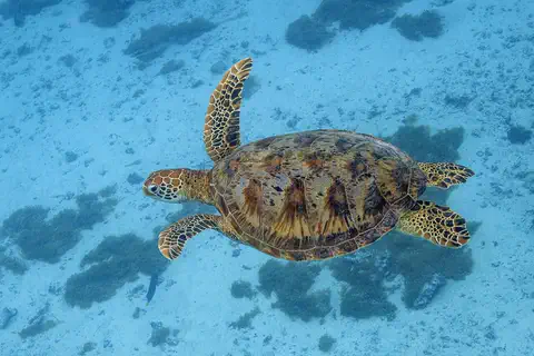
Green sea turtle
The green sea turtle is the largest sea turtle with a hard shell. It lives in warm seas around the world and, unlike other sea turtles, grown-ups eat mostly seagrass and algae. Females swim hundreds or even thousands of kilometers to lay their eggs on the beaches where they hatched long ago.
Explore next
-
 Watch
 Country
Cabo Verde
Cabo Verde is a country made of ten islands in the Atlantic Ocean, about 620 kilometers off the coast of West Africa. Some islands are flat and sandy, others are steep and volcanic, and rain is rare. Its people are famous for their music, and the 2021 census counted about 491,000 people living there.
-
 Watch
 Country
Senegal
Senegal is a country at the far western tip of Africa, on the Atlantic Ocean. Its capital, Dakar, sits on the westernmost point of the continent. About 19 million people live there, and the Senegal River, wetlands full of birds and quiet mangrove deltas make it a place of water as well as dry grassland.
-
 Watch
 Country
Guinea
Guinea is a country on the Atlantic coast of West Africa. Three of West Africa's great rivers, the Niger, the Sénégal and the Gambia, begin in its Fouta Djallon highlands. It has rainy coasts, high plateaus, savanna and rainforest, and about 17.5 million people were counted there in 2025.
-
Watch
Animal
Common hippopotamus
The common hippopotamus is one of the biggest animals on land, yet it spends most of the day resting in rivers and lakes to keep cool. At night it walks out to graze, and its special skin makes its own sunscreen.
-
Watch
Animal
Green sea turtle
The green sea turtle is the largest sea turtle with a hard shell. It lives in warm seas around the world and, unlike other sea turtles, grown-ups eat mostly seagrass and algae. Females swim hundreds or even thousands of kilometers to lay their eggs on the beaches where they hatched long ago.
- Watch Geography Tides Tides are the slow rise and fall of the sea along coasts. The Moon's gravity, helped a little by the Sun, pulls Earth's oceans into two bulges. As Earth turns through them, most coasts get two high tides and two low tides every 24 hours and 50 minutes.
-
 Watch
 Country
Democratic Republic of the Congo
The Democratic Republic of the Congo, or DR Congo, is the second-largest country in Africa. The mighty Congo River curves through its rainforests, volcanoes rise in the east, and its capital, Kinshasa, is a center of music, fashion and popular culture.
-
 Watch
 Country
Ethiopia
Ethiopia is a country on the Horn of Africa with no coast. Much of it is high, rugged land cut by the Great Rift Valley, it is one of the world's oldest countries, and more than 110 million people live there.
For parents & teachers
What children will learn
- Locate Guinea-Bissau, its neighbors and the Bijagós Islands on the Atlantic coast of West Africa.
- Explain how tides shape a low, flat coast and how farmers use tide water for rice.
- Describe why the Bijagós matter for sea turtles, hippos and migrating birds.
- Outline the country's history from Kaabu and Portuguese trade to independence in 1974; older students learn about later coups, told plainly.
Recommended ages: 3 to 17 · About 15 minutes
Talk about it
- What would change in your town if the sea flowed up the river twice a day?
- Why might sea turtles return to the same small island to lay their eggs?
- How can people who speak different languages find a shared way to talk?
Try at home or in class
- Make a tide model: tilt a baking tray with sand at one end, add water, then gently rock the tray and watch the water creep up and back.
- On a map, find all the countries that have a city or region called Guinea, and see how Guinea-Bissau tells itself apart.
Key vocabulary: tide, mangrove, archipelago, delta, creole, World Heritage Site
Where these facts come from
- Wikidata , Wikimedia Foundation (CC0 1.0)
- Natural Earth vector data , Natural Earth (NACIS) (Public domain)
- UNESCO World Heritage List , UNESCO World Heritage Centre (Linked as a reference; site facts come from Wikidata)
- Guinea-Bissau (introduction, quick facts, land, climate, plant and animal life, people, religion, settlement, demographic trends) , Encyclopaedia Britannica
- Guinea-Bissau: Economy (agriculture, forestry and fishing, manufacturing, finance and trade) , Encyclopaedia Britannica
- Guinea-Bissau: Security (health, education, cultural life, sports, media) , Encyclopaedia Britannica
- Guinea-Bissau: History (early history, colonial period, liberation struggle) , Encyclopaedia Britannica
- Guinea-Bissau: Independence , Encyclopaedia Britannica
- Coastal and Marine Ecosystems of the Bijagós Archipelago – Omatí Minhô , UNESCO World Heritage Centre
- RGPH-4 2026: preliminary census results (2,191,202 inhabitants) , Instituto Nacional de Estatística, Guinea-Bissau
- PlayOwl region table, version 1 , PlayOwl (PlayOwl original data)
- flag-icons 7.5.0 , Panayiotis Lipiridis and contributors (MIT)
- Wikimedia Commons , Wikimedia Foundation (Per file (public domain, CC0, CC BY or CC BY-SA); see each media record)
Checked, not yet human-reviewed. Last updated October 27, 2026. Spotted a mistake? Tell us.