
 Country
Africa
Malawi
Malawi is a long, thin country in Africa. A huge lake runs down its side. Hundreds of colorful fish live in the lake.
Malawi is a narrow country in southeastern Africa that curves along the Great Rift Valley. Lake Malawi, one of the deepest lakes in the world, covers more than a fifth of the country, and it is home to hundreds of kinds of colorful fish. About 21 million people lived there in 2026.
Malawi is a landlocked state stretched about 840 km along the East African Rift, where Lake Malawi (Lake Nyasa) covers more than one-fifth of its area and holds more fish species than any other lake, by UNESCO's estimate. Most of its roughly 21.2 million people (National Statistical Office, mid-2026 estimate) are rural farmers on the central plateaus, growing corn for food and tobacco, tea and sugar for export.
Photo: Joachim Huber, CC BY-SA 2.0, via Wikimedia Commons
Discover Malawi
Malawi is a country in Africa.
It is long and thin. A very big lake runs along one side. The capital city is called Lilongwe.
Malawi is a long, narrow country in southeastern Africa. It stretches about 840 kilometers from north to south, but in places it is only 10 kilometers wide. It has no coast on the ocean.
The Great Rift Valley, a huge, long valley, runs right through Malawi, and Lake Malawi fills much of it. The lake covers more than one-fifth of the country. About 21 million people lived in Malawi in 2026, and most of them live in the countryside and farm.
Malawi occupies a narrow, curving strip of land along the East African Rift Valley, about 840 km from north to south and 10 to 160 km wide. Britannica identifies four regions: the Rift Valley, holding Lake Malawi and the Shire River valley; the central plateaus, about three-fourths of the land at 760–1,370 m; highlands such as Nyika, Viphya and the Shire Highlands; and the isolated massifs of Mulanje and Zomba.
Malawi's National Statistical Office estimated 21,201,635 people in mid-2026, projected from the 2018 census. Malawi is one of the most densely populated countries in southern Africa but one of the least urbanized, with more than four-fifths of people living in rural areas, and nearly half are younger than 15. It is a republic; Peter Mutharika is president (2026).
Cities and famous places
Lilongwe is the capital city.
Blantyre is another big city. A tall mountain called Mulanje rises from the plains. Long ago, people painted pictures on rocks in the hills.
Lilongwe, in the middle of the country, has been the capital since 1975. Before that, the capital was Zomba, at the foot of Zomba Mountain. Blantyre, in the southern highlands, is the busiest city for business and factories.
Malawi has three World Heritage Sites. At the south end of the lake is Lake Malawi National Park. In the central hills, the Chongoni rock-art area has 127 sites with paintings on rock. In the south, Mount Mulanje, Malawi's highest mountain, was added in 2025 as a cultural landscape cared for by the people who live around it.
Lilongwe, the capital since 1975 and a center of agricultural industry, lies in the central region; Zomba, the previous capital, is now the seat of the University of Malawi; Blantyre, the industrial and commercial center and seat of the judiciary, sits on the Shire Highlands at about 1,040 m; and Mzuzu, on the Viphya highlands, is long associated with the wood industry.
Lake Malawi National Park (1984) protects the lake's southern end. The Chongoni Rock-Art Area (2006), 126.4 km² of forested granite hills on the central plateau, has 127 sites, the richest concentration of rock art in Central Africa, painted by BaTwa hunter-gatherers and by Chewa farmers into the 20th century. Mount Mulanje Cultural Landscape (2025) is valued for the traditional stewardship of the Yao, Mang'anja and Lhomwe communities, whose codes of conduct govern access to the mountain and the use of its plants and other natural resources.

A lake in the Rift Valley
Lake Malawi is very big and very deep.
Its water is clear and blue. Rocky islands poke out of it. There is a wet season and a dry season.
Lake Malawi lies in the Rift Valley and is one of the deepest lakes in the world. Its water is very clear, and rocky shores, sandy bays and islands line its edges. The Shire River is the only river that flows out of it, carrying water south to the Zambezi.
Around the lake rise plateaus and mountains. Mount Mulanje, in the south, reaches 3,002 meters, the highest point in Malawi. The dry season lasts from May to October and the wet season from November to April. On the high Nyika Plateau there can even be frost in July.
Lake Malawi covers about 29,600 km², part of it beyond Malawi's borders, and is fed by rivers including the North and South Rukuru, Dwangwa, Lilongwe and Bua; the Shire River, its only outlet, passes through Lake Malombe and joins the Zambezi in Mozambique. UNESCO describes it as one of the deepest lakes in the world, with remarkably clear water set against the Rift escarpment. Mulanje (3,002 m) and Zomba (2,087 m) rise abruptly from the Shire Highlands.
The dry season runs from May to October and the wet season from November to April. Temperatures fall with height: Nsanje, in the Shire valley, averages in the high 20s °C in October, while Dedza, above 1,500 m, averages in the mid-10s °C in July, and frost is not unusual on the Nyika Plateau. Rain reaches about 2,300 mm on parts of the northern highlands and on Mulanje's Sapitwa peak but only 650–900 mm in the lower Shire valley. Miombo woodland, savanna and grassy depressions called madambo cover much of the land, though much original woodland has been cleared.
Animals of Malawi
Lake Malawi is full of bright little fish.
They come in many bright colors. Hippos live in the lake too. Elephants and zebras live in the parks.
Lake Malawi may have more kinds of fish than any other lake in the world: UNESCO estimates up to about 1,000. Many are small, brightly colored fish called cichlids, and most of them live nowhere else on Earth. People also catch a fish called chambo to eat.
Hippos live in the lake. In the game reserves and parks live elephants, buffalo, zebras, leopards and antelopes. Big wild animals are common only in the parks and reserves.
UNESCO estimates up to about 1,000 fish species in Lake Malawi, about half within the national park, the largest number of fish species known from any lake. Of more than 350 species of mbuna, small, brightly colored rock-dwelling cichlids, all but five are endemic, and the lake holds about 30 percent of all known cichlid species; UNESCO compares their value for studying evolution with Darwin's Galápagos finches. Commercial catches rely on the endemic tilapia called chambo, on catfish (mlamba) and on minnows (matemba).
Britannica notes that large game animals abound only in reserves, with hippos in the lake. The IUCN Red List maps the African bush elephant, African buffalo, plains zebra, leopard, hippopotamus and Nile crocodile as living in Malawi today. Swamp drainage, woodland clearing and intensive farming have greatly altered natural habitats, and deforestation and land degradation are major environmental concerns.

People, languages and food
About 21 million people live in Malawi.
Many people speak Chewa. Most families are farmers. They grow corn, beans and peanuts.
About 21 million people lived in Malawi in 2026, and nearly half of Malawi's people are younger than 15. Malawi has many peoples, among them the Chewa, Nyanja, Lomwe, Yao, Tumbuka and Ngoni. Chewa is spoken by most people, and English is used in schools from grade 5, in government and in business.
Most families farm small plots of land. Corn is the main food crop, grown with beans, peas and peanuts, and people also grow cassava, bananas, sweet potatoes and rice. Tobacco, tea and sugar are grown to sell to other countries.
Britannica names ten major ethnic groups historically associated with Malawi: Chewa, Nyanja, Lomwe, Yao, Tumbuka, Sena, Tonga, Ngoni, Ngonde and Lambya/Nyiha, all speaking Bantu languages. Chewa, the sole national language from 1968 to 1994, is spoken by a majority; since 1996 grades 1–4 are taught in children's home languages and English from grade 5. About three-fourths of people are Christian and about one-fifth Muslim, with a small share following traditional beliefs.
Agriculture employed more than four-fifths of workers in the 2000s. Corn is the staple, grown with beans, peas and peanuts by virtually all smallholders, most of whom farm less than 1 hectare. Tobacco is by far the most important export, followed by tea, sugar and cotton, largely from estates. Primary school, starting at age six and lasting eight years, has been free since 1994. Traditional round, mud-walled, grass-roofed houses are giving way to brick buildings with metal roofs.
Kingdoms, Nyasaland and independence
People have lived in Malawi for a very, very long time.
Long ago, kings ruled big kingdoms here. Later, Britain ruled the land. In 1964, Malawi became its own country.
People have lived in Malawi for many thousands of years. Hunter-gatherers painted pictures on rocks, and later Bantu-speaking farmers arrived and began working iron. About the year 1480, new groups formed the Maravi Confederacy, which grew to cover most of central and southern Malawi.
In the 1800s, missionaries and traders arrived, and in 1891 Britain made the land a protectorate, later called Nyasaland. People in Malawi worked to govern themselves, and on July 6, 1964, Malawi became an independent country.
Human artifacts in Malawi date back more than 50,000 years. Bantu-speaking peoples arrived between the 1st and 4th centuries CE, bringing ironworking; a later wave in the 13th–15th centuries founded the Maravi Confederacy about 1480, and the Ngonde kingdom arose about 1600. The slave trade grew sharply between 1790 and 1860, with Swahili-speaking and Yao traders playing major roles. Islam came from the east coast in the 1860s, and Christianity with David Livingstone and Scottish missionaries.
Britain set up a protectorate in 1891, named Nyasaland in 1907, and in the early 1950s joined it to the Federation of Rhodesia and Nyasaland against strong African opposition; the federation was dissolved in 1963. A nationalist movement led by Hastings Kamuzu Banda won independence on July 6, 1964; Malawi became a republic in 1966 and a one-party state under Banda, who was made president for life in 1971. After a referendum, the first free elections in more than 30 years were held in May 1994, and a new constitution followed in 1995.
Malawi on the map
Find Malawi on the globe.
It is in the southeast of Africa. It has no sea. A long lake lies along its east side.
Malawi is in southeastern Africa. Tanzania lies to the north, Zambia to the west, and Mozambique wraps around the east and south. Lake Malawi forms much of the eastern side.
Malawi is long and thin, following the Rift Valley. At the south end of the lake, the Shire River flows on through a long valley toward Mozambique.
Britannica gives Malawi's borders as Tanzania to the north, Lake Malawi to the east, Mozambique to the east and south and Zambia to the west. The lake, also called Lake Nyasa, extends beyond the country's borders.
The Shire valley runs about 400 km from the lake's southern end at Mangochi to Nsanje on the Mozambique border, with Lake Malombe at its head. A second drainage system centers on Lake Chilwa in the southeast, below the Mulanje and Zomba massifs.
- Highest point
- Mulanje, 3,002 m
- North to south
- about 840 km
- Lake Malawi
- about 29,600 km²
- People (mid-2026 official estimate)
- 21,201,635
Amazing facts
-
Lake Malawi has more kinds of fish than any other lake.
UNESCO estimates that Lake Malawi has up to about 1,000 kinds of fish, the most of any lake in the world.
UNESCO estimates up to about 1,000 fish species in Lake Malawi, the largest number of any lake in the world, with very high endemism among its cichlids.
-
Malawi is long and thin, like a ribbon.
Malawi is about 840 kilometers long but only 10 to 160 kilometers wide.
Malawi stretches about 840 km from north to south and varies in width from 10 to 160 km, following the curve of the Rift Valley.
-
People painted pictures on rocks in Malawi's hills.
The Chongoni hills have 127 rock-art sites, with paintings by hunter-gatherers and later by Chewa farmers.
Chongoni's 127 sites hold the richest concentration of rock art in Central Africa; Chewa farmers painted there until well into the 20th century.
-
Frost can cover Malawi's high plateau in July.
On the high Nyika Plateau and the upper slopes of Mount Mulanje, frost is not unusual in July.
Frosts are not uncommon in July on the Nyika Plateau and the upper Mulanje massif, while the lower Shire valley averages in the high 20s °C in October.
Words to know
- rift valley
- a long, low valley formed where Earth's crust is being pulled apart
- landlocked
- having no coast on the sea or ocean
- cichlid
- a family of fish with many kinds, many of them brightly colored
- endemic
- found naturally in only one place
- plateau
- a large area of high, fairly flat land
- rock art
- pictures painted or carved on rock by people long ago
Discovery challenge
-
What is the capital city of Malawi?
Which city has been Malawi's capital since 1975?
Which city replaced Zomba as Malawi's capital in 1975?
- Blantyre
- Lilongwe
- Nairobi
Show the answer
Lilongwe
Lilongwe is the capital of Malawi.
Lilongwe has been the capital since 1975. Blantyre is the main city for business.
Lilongwe, a center of agricultural industry, replaced Zomba in 1975; Blantyre is the commercial center.
-
What lives in Lake Malawi in huge numbers of kinds?
Lake Malawi may have more kinds of what than any other lake?
UNESCO estimates that Lake Malawi has more species of which animals than any other lake?
- Fish
- Penguins
- Frogs
Show the answer
Fish
Lake Malawi is full of many kinds of fish.
UNESCO estimates up to about 1,000 kinds of fish in the lake, most of them cichlids.
Up to about 1,000 fish species, including more than 350 mbuna, all but five endemic.
-
What is Malawi's shape like?
What shape is Malawi?
Which description fits Malawi's shape along the Rift Valley?
- Round like a ball
- Long and narrow
- A perfect square
Show the answer
Long and narrow
Malawi is long and thin.
Malawi is about 840 kilometers long but only 10 to 160 kilometers wide.
It is a narrow, curving strip of land about 840 km long following the East African Rift.
-
What is the main food crop in Malawi?
Which crop is the main food crop for Malawi's farmers?
Which staple do virtually all Malawian smallholders grow, often with beans, peas and peanuts?
- Corn
- Wheat
- Apples
Show the answer
Corn
Corn is the main food crop.
Corn, also called maize, is grown all over Malawi, often with beans and peanuts.
Corn (maize) is the principal food crop, interplanted with beans, peas and groundnuts by smallholders.
-
Which mountain is the highest in Malawi?
Which mountain, 3,002 meters tall, is the highest in Malawi?
Which massif, inscribed by UNESCO as a cultural landscape in 2025, holds Malawi's highest point?
- Mount Kilimanjaro
- Mount Mulanje
- Mount Everest
Show the answer
Mount Mulanje
Mount Mulanje is the tallest mountain in Malawi.
Mount Mulanje, in the south, is 3,002 meters tall.
The Mulanje massif reaches 3,002 m at Sapitwa and became a World Heritage cultural landscape in 2025.
Places to discover in Malawi
Animals of Malawi
Explore next
-
 Watch
Natural wonder
Great Rift Valley
The Great Rift Valley is a huge valley that runs through East Africa, where the continent is slowly being stretched and pulled apart. Long, steep cliffs line its sides, its floor holds lakes full of flamingos, and giant volcanoes such as Kilimanjaro and Mount Kenya rose beside it. Scientists think a new ocean may one day open here.
-
 Watch
 Country
Tanzania
Tanzania is a country in East Africa, just south of the Equator, on the Indian Ocean. It has Mount Kilimanjaro, Africa's highest mountain, deep lakes in the East African Rift, and the Serengeti, where huge herds of wildebeest travel each year.
-
 Watch
 Country
Mozambique
Mozambique stretches along the Indian Ocean coast of southeastern Africa. The great Zambezi River cuts through its middle, its beaches face the island of Madagascar, and parks like Gorongosa are home to elephants and lions. About 35.6 million people lived there in 2025, and Portuguese is the official language.
-
 Watch
 Country
Zambia
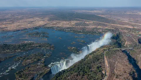
Zambia is a landlocked country on a high plateau in south-central Africa, named after the Zambezi River. On its southern border the Zambezi thunders over Victoria Falls. About 22 million people live there, and its copper mines have long made it one of Africa's great copper producers.
-
Watch
Animal
Common hippopotamus
The common hippopotamus is one of the biggest animals on land, yet it spends most of the day resting in rivers and lakes to keep cool. At night it walks out to graze, and its special skin makes its own sunscreen.
-
 Watch
 Country
Democratic Republic of the Congo
The Democratic Republic of the Congo, or DR Congo, is the second-largest country in Africa. The mighty Congo River curves through its rainforests, volcanoes rise in the east, and its capital, Kinshasa, is a center of music, fashion and popular culture.
-
 Watch
 Country
Ethiopia
Ethiopia is a country on the Horn of Africa with no coast. Much of it is high, rugged land cut by the Great Rift Valley, it is one of the world's oldest countries, and more than 110 million people live there.
-
 Watch
 Country
Kenya
Kenya is a country in East Africa, crossed by the equator. It has the snow-capped Mount Kenya, the deep Great Rift Valley, Lake Victoria and a long Indian Ocean coast, and about 54 million people live there, many of them speaking Swahili.
For parents & teachers
What children will learn
- Locate Malawi, its neighbors and Lake Malawi in the East African Rift Valley.
- Explain why Lake Malawi's cichlid fish matter to scientists who study evolution.
- Describe how most people in Malawi live and farm, and what the country grows and sells.
- Outline Malawi's history from the Maravi Confederacy and Nyasaland to independence in 1964.
Recommended ages: 3 to 17 · About 15 minutes
Talk about it
- Why might a lake that is cut off from other waters end up with fish found nowhere else?
- Most people in Malawi farm small plots. What would you need to grow your own food?
- Why do you think people paint pictures on rocks, and what would you paint?
Try at home or in class
- Cut a long, thin country shape from paper and lay it beside a blue paper lake to see how Malawi follows the lake.
- Sort a handful of buttons or beads by color and shape to see how scientists group many similar cichlid species.
Key vocabulary: rift valley, landlocked, cichlid, endemic, plateau, rock art
Where these facts come from
- Wikidata , Wikimedia Foundation (CC0 1.0)
- Natural Earth vector data , Natural Earth (NACIS) (Public domain)
- UNESCO World Heritage List , UNESCO World Heritage Centre (Linked as a reference; site facts come from Wikidata)
- The IUCN Red List of Threatened Species , International Union for Conservation of Nature (IUCN terms of use (no redistribution of Red List data or range maps))
- Malawi (introduction, quick facts, land, drainage, climate, plant and animal life) , Encyclopaedia Britannica
- Malawi: People (ethnic groups, languages, religion, settlement, demographic trends, economy, agriculture) , Encyclopaedia Britannica
- Malawi: Education (education, cultural life) , Encyclopaedia Britannica
- Malawi: History , Encyclopaedia Britannica
- Malawi: Malawi since 1994 , Encyclopaedia Britannica
- Lake Malawi National Park , UNESCO World Heritage Centre
- Chongoni Rock-Art Area , UNESCO World Heritage Centre
- Mount Mulanje Cultural Landscape , UNESCO World Heritage Centre
- Malawi at a Glance: population (mid-year 2026), 21,201,635 , National Statistical Office of Malawi
- PlayOwl region table, version 1 , PlayOwl (PlayOwl original data)
- flag-icons 7.5.0 , Panayiotis Lipiridis and contributors (MIT)
- Wikimedia Commons , Wikimedia Foundation (Per file (public domain, CC0, CC BY or CC BY-SA); see each media record)
Checked, not yet human-reviewed. Last updated October 27, 2026. Spotted a mistake? Tell us.
Picture credits
- Photo: Joachim Huber, CC BY-SA 2.0, via Wikimedia Commons · source · license
- Photo: Brian Dell, public domain, via Wikimedia Commons · source
- Photo: Diego Delso, CC BY-SA 4.0, via Wikimedia Commons · source · license
- Photo: Giles Laurent, CC BY-SA 4.0, via Wikimedia Commons · source · license
- Photo: Giles Laurent, CC BY-SA 4.0, via Wikimedia Commons · source · license