
 Country
Africa
Tanzania
Tanzania is a big country in East Africa. It has Africa's tallest mountain, huge lakes and lots of wild animals.
Tanzania is a country in East Africa, just south of the Equator, on the Indian Ocean. It has Mount Kilimanjaro, Africa's highest mountain, deep lakes in the East African Rift, and the Serengeti, where huge herds of wildebeest travel each year.
Tanzania was formed in 1964 by the union of mainland Tanganyika and the islands of Zanzibar. Two branches of the East African Rift System cross the mainland, which rises to Kilimanjaro (5,895 m), and the national statistics bureau projected about 70 million people for 2026.
Photo: Bjørn Christian Tørrissen, CC BY-SA 3.0, via Wikimedia Commons
Discover Tanzania
Tanzania is a country in Africa.
It is next to the Indian Ocean. It has wide grassy plains and tall mountains. Some islands belong to Tanzania too. The capital city is Dodoma.
Tanzania is in East Africa, just south of the Equator. Its east coast faces the Indian Ocean, and the islands of Zanzibar and Pemba lie just offshore. The mainland makes up more than 99 percent of the country.
Most of the mainland is wide plains and plateaus, but it also has Africa's highest mountain, Kilimanjaro, and some of the world's biggest lakes. The capital, Dodoma, is in the middle of the country. Dar es Salaam, on the coast, is the largest city and the main port.
Tanzania lies just south of the Equator in East Africa. It was formed as a sovereign state on April 26, 1964, by the union of Tanganyika on the mainland and Zanzibar offshore, and took its present name, the United Republic of Tanzania, in October 1964. The mainland covers more than 99 percent of the combined territory; Zanzibar and Pemba have their own government administration, while Mafia Island is run from the mainland.
Except for a narrow coastal belt and the islands, most of the mainland lies above 200 meters. Broad plains and plateaus contrast with dramatic relief: Kilimanjaro, at 5,895 meters the highest point in Africa, and Lake Tanganyika, about 1,436 meters deep. Dodoma, the capital, is near the center of the mainland, and Dar es Salaam is the largest city and port. Tanzania's National Bureau of Statistics projected a population of 70,038,850 for 2026.
Cities and famous places
Dar es Salaam is a big city by the sea.
Zanzibar is an island with an old stone town. Many of its houses have big carved doors. Long ago, ships came here to trade.
Dar es Salaam is Tanzania's largest city and its largest port. Off the coast, the island of Unguja (Zanzibar) has Stone Town, a World Heritage Site since 2000. Its houses are built of coral stone and mangrove wood, and many have big carved double doors.
Farther south, on two small islands, are the ruins of Kilwa Kisiwani and Songo Mnara. From the 1200s to the 1500s their merchants traded gold and ivory for silver, perfumes, pottery from Persia and porcelain from China. In the north, the town of Moshi looks out toward Kilimanjaro.
Dar es Salaam is the largest city and port. On Unguja island, UNESCO describes the Stone Town of Zanzibar (inscribed 2000) as an outstanding example of a Swahili coastal trading town, blending African, Arab, Indian and European influences over more than a thousand years. Its buildings are mostly of coralline ragstone and mangrove timber set in lime mortar, and its two-story houses are known for elaborately carved double 'Zanzibar' doors. UNESCO notes that the Anglican cathedral there was built on the site of the town's last slave market.
About 300 km south of Dar es Salaam lie the ruins of Kilwa Kisiwani and Songo Mnara (inscribed 1981). Kilwa was occupied from the 9th to the 19th century and peaked in the 13th and 14th; it minted its own coins, and in 1331-1332 the traveler Ibn Battuta described it as one of the most beautiful cities in the world. Its Great Mosque dates from the 11th century, and some of its domes are decorated with Chinese porcelain.

Mountains, rift valleys and lakes
Kilimanjaro is the tallest mountain in Africa.
Its top has snow and ice. Kilimanjaro is a volcano. Tanzania also has very big lakes. One lake is very, very deep.
Kilimanjaro rises 5,895 meters, the highest point in Africa. It is a huge volcanic mountain with three main peaks, Kibo, Mawenzi and Shira, and its snowy top stands alone above the plains.
Two long cracks in Earth's crust, branches of the East African Rift, run through Tanzania. Many of their deep, narrow valleys are filled with lakes, such as Lake Tanganyika, the second deepest lake in the world. In the north, Ngorongoro Crater is the world's largest caldera, a giant bowl left by a volcano. Lake Victoria, on the northern border, is not in the rift.
Kilimanjaro, 5,895 m, is the highest mountain in Africa and one of the largest volcanoes in the world, rising about 4,877 m above the surrounding plains. UNESCO (inscribed 1987) lists five vegetation zones from its lower slopes through montane forest, heath and moorland and alpine desert to the summit, and warns that its glaciers are vulnerable to retreat.
The East African Rift System crosses the mainland in two north-south branches. The Western Rift follows the western frontier and holds Lakes Tanganyika (about 1,436 m deep, the world's second deepest) and Rukwa; the Eastern or Great Rift runs from the Kenyan border near Lakes Eyasi, Manyara and Natron south to Lake Nyasa. The central plateau, over a third of the country, lies between them. West of Mount Meru (4,565 m), a chain of mountains includes the still-active volcano Ol Doinyo Lengai and Ngorongoro, the world's largest caldera. Lake Victoria, the world's second largest freshwater lake, is not part of the rift; about 59,000 km² of Tanzania is inland water. Rainfall is seasonal: roughly half the mainland gets less than 750 mm a year.

Animals of Tanzania
Tanzania has lions, zebras and giraffes.
Huge herds of wildebeest walk across the Serengeti. They look for grass and water. Hippos and crocodiles live by rivers and lakes.
Tanzania has an amazing mix of wildlife. Herds of wildebeest, zebras, giraffes, buffalo, gazelles and elands live in its parks, along with lions, leopards, cheetahs, hyenas and wild dogs. Hippos and crocodiles are common along rivers and lakes, and small groups of chimpanzees live in Gombe National Park on Lake Tanganyika.
In the Serengeti, about two million wildebeest, with hundreds of thousands of gazelles and zebras, travel in a great circle every year in search of grass and water. Their predators follow them. About a quarter of Tanzania's land is set aside for parks and reserves.
Britannica attributes Tanzania's exceptionally rich wildlife to the historically low density of human settlement. Hoofed animals include wildebeest, zebras, giraffes, buffalo, gazelles, elands, dik-diks and kudu; predators include hyenas, wild dogs, lions, leopards and cheetahs. Nearly 1,500 kinds of birds have been reported, and the government has taken special measures to protect rhinoceroses and elephants from poaching. About one-fourth of the land forms a network of reserves, conservation areas and national parks.
UNESCO describes the Serengeti (inscribed 1981) as hosting the largest remaining unaltered animal migration in the world: over a million wildebeest plus hundreds of thousands of other hoofed animals make a 1,000 km circular trek across Tanzania and Kenya. It lists about 2 million wildebeest, 900,000 Thomson's gazelles and 300,000 zebras, more than 500 bird species, and at least four globally threatened or endangered species: black rhino, elephant, wild dog and cheetah. In the Ngorongoro Conservation Area, established in 1959, wildlife shares the land with semi-nomadic Maasai herders.

People, languages and food
Tanzania has many different peoples.
Almost everyone speaks Swahili. Many people also speak the language of their own group. Farmers grow corn, rice, bananas and cassava.
More than 120 African peoples live in Tanzania, including the Sukuma, the largest group, the Chaga on the slopes of Kilimanjaro and the Maasai in the north. Swahili and English are the official languages. Almost everyone speaks Swahili, and children learn in Swahili in the first seven years of primary school.
Farming is very important. Corn (maize) and rice are the preferred grains, and farmers also grow bananas, cassava, millet and sweet potatoes. Coffee, cotton, tea and cashew nuts are grown to sell abroad. Football (soccer) is widely played and watched, and Makonde carvers in the south are famous for their ebony carvings.
Most surveys count more than 120 indigenous African peoples in Tanzania. Most are of Bantu descent, the Sukuma south of Lake Victoria being the largest group; others include the Nyamwezi, Hehe, Haya, Chaga and Makonde, while Nilotic peoples such as the Maasai live in the north-central mainland. Britannica notes that, unlike many African countries, Tanzania has no single politically or culturally dominant ethnic group. Swahili, which grew from Bantu dialects and Arabic on the coast and Zanzibar, is the national language and lingua franca; English is the other official language and is used in higher education. Roughly one-third of people are Muslim and almost two-thirds Christian, and on Zanzibar almost everyone is Muslim.
About two-fifths of the population works in farming. The main food crops are corn, rice, sorghum, millet, bananas, cassava and sweet potatoes, and coffee and cotton are the leading export crops. Zanzibar once grew more than nine-tenths of the world's cloves. More than two-fifths of Tanzanians are under 15, and almost one-third live in towns and cities.

A long history
People have lived here for a very, very long time.
Very old bones and footprints were found here. Long ago, ships came to the coast to trade. In 1964, two places joined to make Tanzania.
Tanzania holds important clues about early humans. In Olduvai Gorge, in 1959, Mary Leakey found a nearly perfect fossil skull more than a million years old, and at Laetoli there are fossil footprints about 3.6 million years old.
For centuries, traders sailed to the coast from Arabia, Persia and India, and Swahili trading towns such as Kilwa grew rich. Later, Germany ruled the mainland as German East Africa, and later Britain ruled it as Tanganyika. Tanganyika became independent in 1961, Zanzibar in 1963, and in 1964 the two joined to form Tanzania.
In Olduvai Gorge, in 1959, Mary Leakey found a near-perfect skull now classed as Paranthropus boisei, a hominin that lived there between 2.3 and 1.2 million years ago; nearby Laetoli has fossil footprints about 3.6 million years old. Traders from Arabia, Persia and India came to the coast over many centuries, and Arab-controlled trading towns grew there. In the 19th century Sa'id ibn Sultan, ruler of Muscat (Oman), moved his capital from Muscat to Zanzibar, and Arab traders pushed farther inland in search of slaves and ivory.
Germany declared a protectorate over German East Africa in 1891; the Maji Maji rebellion against German rule spread across the southeast from 1905 until 1907. After World War I, Britain governed Tanganyika under a League of Nations mandate and, from 1947, a UN trusteeship. After the Tanganyika African National Union, led by Julius Nyerere, won the elections of 1958-1960, Tanganyika became independent on December 9, 1961, with Nyerere as prime minister; Zanzibar became independent on December 10, 1963, and the two united on April 26, 1964. The 1967 Arusha Declaration set out Nyerere's policy of ujamaa ('familyhood'), and a 1992 amendment to the constitution allowed several political parties.

Tanzania on the map
Find Tanzania on the globe.
It is in Africa, a little below the Equator. The Indian Ocean is on one side. Big lakes are on its edges.
Tanzania is in East Africa, just south of the Equator. Uganda and Kenya are to the north, and Lake Victoria sits on the northern border. The Indian Ocean is to the east, with the islands of Zanzibar and Pemba close to the shore.
To the south are Mozambique, Malawi and Zambia, with Lake Nyasa on the border. To the west are Lake Tanganyika, Burundi and Rwanda. Tanzania forms the divide where three of Africa's great rivers, the Nile, the Congo and the Zambezi, begin.
The mainland is bounded by Uganda, Lake Victoria and Kenya to the north; the Indian Ocean to the east; Mozambique, Lake Nyasa, Malawi and Zambia to the south and southwest; and Lake Tanganyika, Burundi and Rwanda to the west. Zanzibar is about 35 km off the coast and Pemba about 56 km; both are low islands built of coral rock.
Although Tanzania has no very large rivers, it forms the divide from which the Nile, the Congo and the Zambezi rise, flowing to the Mediterranean, the Atlantic and the Indian Ocean. All its major rivers, the Ruvuma, Rufiji, Wami and Pangani, drain into the Indian Ocean; the Rufiji is the largest, and the Kagera flows into Lake Victoria.
- Highest point
- Kilimanjaro, 5,895 m
- Lake Tanganyika depth
- about 1,436 m
- Inland water
- about 59,000 km²
- People (2026 projection)
- 70,038,850
Amazing facts
-
Tanzania has the tallest mountain in Africa.
Kilimanjaro, 5,895 meters high, is the highest point in Africa, and it has three main volcanic peaks.
UNESCO describes Kilimanjaro as one of the largest volcanoes in the world, with three main peaks, Kibo, Mawenzi and Shira, rising about 4,877 m above the plains.
-
Millions of wildebeest walk across the Serengeti.
About two million wildebeest, plus hundreds of thousands of gazelles and zebras, travel around the Serengeti every year.
UNESCO counts about 2 million wildebeest, 900,000 Thomson's gazelles and 300,000 zebras in the Serengeti ecosystem, on a 1,000 km circular trek shared with Kenya.
-
Lake Tanganyika is very, very deep.
Lake Tanganyika is about 1,436 meters deep, the second deepest lake in the world.
Lake Tanganyika, in the Western Rift Valley, is about 1,436 m (4,710 ft) deep, the world's second deepest lake.
-
Very old footprints were found in Tanzania.
At Laetoli, in the Ngorongoro Conservation Area, there are fossil footprints about 3.6 million years old.
UNESCO links the fossilized footprints at Laetoli, about 3.6 million years old, with the development of walking on two legs in human evolution.
-
Long ago, Kilwa made its own coins.
The old trading city of Kilwa Kisiwani minted its own coins between the 1000s and the 1300s.
Kilwa Kisiwani minted its own currency from the 11th to the 14th century, while its merchants traded gold and ivory for Chinese porcelain and Persian faience.
Words to know
- rift valley
- a long, low valley formed where Earth's crust is pulling apart
- caldera
- a huge bowl-shaped hollow left when a volcano collapses
- migration
- a regular journey animals make from one place to another
- lingua franca
- a shared language that people with different first languages use to talk to each other
- Swahili
- a Bantu language of the East African coast, spoken by almost everyone in Tanzania
- fossil
- the remains or traces of a living thing from long ago, preserved in rock
- World Heritage Site
- a place UNESCO lists as important to all people, to be protected
Discovery challenge
-
What is the tallest mountain in Africa?
Which mountain in Tanzania is the highest in Africa?
Which volcanic massif, 5,895 m high, is the highest point in Africa?
- Mount Everest
- Kilimanjaro
- Mount Fuji
Show the answer
Kilimanjaro
Kilimanjaro is the tallest mountain in Africa.
Kilimanjaro, in northern Tanzania, is 5,895 meters high, the highest point in Africa.
Kilimanjaro's highest peak, Kibo, reaches 5,895 m; UNESCO inscribed Kilimanjaro National Park in 1987.
-
Which animals walk across the Serengeti in huge herds?
About two million of which animal travel around the Serengeti each year?
Which animal forms the largest herd in the Serengeti migration, about two million strong?
- Penguins
- Kangaroos
- Wildebeest
Show the answer
Wildebeest
Wildebeest walk across the Serengeti to find grass and water.
About two million wildebeest, with many zebras and gazelles, travel around the Serengeti every year.
UNESCO lists about 2 million wildebeest on a 1,000 km circular trek through Tanzania and Kenya, followed by their predators.
-
What language do almost all people in Tanzania speak?
Which language do almost all Tanzanians speak?
Which language is Tanzania's national language and lingua franca?
- Swahili
- French
- Japanese
Show the answer
Swahili
Almost everyone in Tanzania speaks Swahili.
Swahili is spoken by almost everyone, and children learn in Swahili in primary school.
Swahili, which grew from Bantu dialects and Arabic on the coast, is the national language and lingua franca; English is also official.
-
Lake Tanganyika is very what?
Lake Tanganyika is the second most what lake in the world?
Lake Tanganyika, about 1,436 m from surface to floor, ranks second in the world for what?
- Deep
- Salty
- Cold
Show the answer
Deep
Lake Tanganyika is very, very deep.
It is about 1,436 meters deep, the second deepest lake in the world.
Lake Tanganyika fills a trough of the Western Rift and is about 1,436 m deep.
-
Which island joined with Tanganyika to make Tanzania?
In 1964 Tanganyika joined with which island to form Tanzania?
Tanzania was formed on April 26, 1964, by the union of Tanganyika and which state?
- Madagascar
- Zanzibar
- Sri Lanka
Show the answer
Zanzibar
Tanganyika and Zanzibar joined to make Tanzania.
Tanganyika on the mainland and the islands of Zanzibar joined in 1964 to make one country.
Tanganyika (independent 1961) and Zanzibar (independent 1963) united on April 26, 1964, and the country was named the United Republic of Tanzania in October 1964.
Places to discover in Tanzania
-
Watch
Natural wonder
Mount Kilimanjaro
Mount Kilimanjaro, in northeastern Tanzania, is what UNESCO calls the highest mountain in Africa: its top is 5,895 meters high. It is a huge volcanic mountain standing alone above the plains, and as you climb it you pass through farms, forest, moorland and high alpine desert to its icy top.
-
Watch
Natural wonder
Serengeti National Park
Serengeti National Park in northern Tanzania protects 14,763 square kilometers of grassy plains and woodlands. Each year more than a million wildebeest, with zebras and gazelles, travel a great loop across the Serengeti and into Kenya in search of grass and water, followed by lions and other predators.
-
 Watch
Natural wonder
Lake Victoria
Lake Victoria is the largest lake in Africa, and Britannica says only Lake Superior, in North America, is a bigger freshwater lake. It is shared by Kenya, Tanzania and Uganda. The lake is wide but shallow, its only outlet is the Nile, and it is home to hundreds of kinds of colorful fish called cichlids.
-
Watch
Natural wonder
Lake Tanganyika
Lake Tanganyika lies in a deep crack in Africa called a rift valley. Britannica calls it the longest freshwater lake in the world, and only Lake Baikal, in Russia, is deeper. Four countries share it: Tanzania, the Democratic Republic of the Congo, Burundi and Zambia. Its water is home to about 250 kinds of cichlid fish found nowhere else.
-
 Watch
Natural wonder
Great Rift Valley
The Great Rift Valley is a huge valley that runs through East Africa, where the continent is slowly being stretched and pulled apart. Long, steep cliffs line its sides, its floor holds lakes full of flamingos, and giant volcanoes such as Kilimanjaro and Mount Kenya rose beside it. Scientists think a new ocean may one day open here.
-
Watch
Natural wonder
Ngorongoro Conservation Area
The Ngorongoro Conservation Area in northern Tanzania holds the Ngorongoro Crater, a giant bowl about 16 to 20 kilometers across, left when an ancient volcano collapsed about 2.5 million years ago. Around 25,000 large animals live in and around the crater. The area also protects Olduvai Gorge and Laetoli, where scientists have found important evidence of how humans evolved.
Animals of Tanzania
-
 Watch
Animal
Blue wildebeest
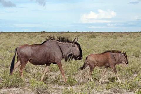
The blue wildebeest, or gnu, is a big antelope with a box-like head, curved horns, a mane and a beard. It grazes the savannas of eastern and southern Africa, and in the Serengeti huge herds travel in a giant circle every year following the rains.
-
 Watch
3D
Animal
Lesser flamingo
The lesser flamingo is the smallest flamingo. Millions live on salty, soda-rich lakes in Africa and India, where they sweep their upside-down bills through the water to filter out tiny algae, which help give them their pink color.
-
 Watch
Animal
Giant African millipede
The giant African millipede is one of the largest millipedes in the world, usually 16 to 28 centimeters long. It lives in the lowlands of East Africa, from Kenya to Mozambique, where it eats dead plants and helps turn them back into soil. Like all millipedes, it has two pairs of legs on most body rings and adds rings and legs as it grows.
-
 Watch
Animal
African buffalo
The African buffalo is a huge, cow-like grazer with heavy, curving horns. It lives in herds that can number in the thousands, and a herd will rush to protect a calf in danger. It lives across much of Africa south of the Sahara, from open savannas to rainforests.
-
 Watch
Animal
Black mamba
The black mamba is a long, slender, very fast snake of the savannas and rocky hills of sub-Saharan Africa. It is gray to brown, gets its name from its inky-black mouth, hunts small mammals by day, and is shy: it would almost always rather slip away from people. It is also highly venomous, so it is a snake to admire from far away.
-
 Watch
3D
Animal
West Indian Ocean coelacanth
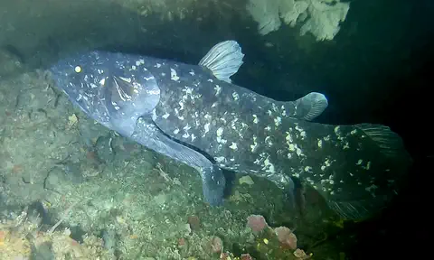
The West Indian Ocean coelacanth is a large, blue, spotted fish that lives in deep, rocky waters off eastern Africa. Its group was known only from fossils and thought to have died out about 66 million years ago, until a living one was found in South Africa in 1938.
-
 Watch
3D
Animal
Serval
The serval is a slender wild cat of African grasslands and wetlands. Its huge ears can hear mice moving in tall grass, and its long legs let it leap high into the air to pounce on them or snatch a bird.
-
 Watch
Animal
Magnificent sea anemone
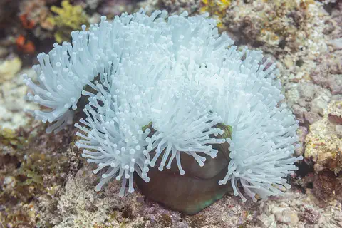
The magnificent sea anemone is a large sea anemone of warm Indian and Pacific Ocean reefs. Its body is a soft column topped with hundreds of finger-shaped tentacles, and it often perches on top of rocks in plain view. Many kinds of clownfish live safely among its stinging tentacles.
-
 Watch
3D
Animal
Spotted hyena
The spotted hyena is the largest of the hyenas and a skilled hunter of the African savanna. Many people think hyenas only eat leftovers, but in East and Southern Africa they catch most of their own food. They live in big clans led by females, and they whoop, groan and 'giggle' to talk.
Explore next
-
Watch
Natural wonder
Mount Kilimanjaro
Mount Kilimanjaro, in northeastern Tanzania, is what UNESCO calls the highest mountain in Africa: its top is 5,895 meters high. It is a huge volcanic mountain standing alone above the plains, and as you climb it you pass through farms, forest, moorland and high alpine desert to its icy top.
-
Watch
Natural wonder
Serengeti National Park
Serengeti National Park in northern Tanzania protects 14,763 square kilometers of grassy plains and woodlands. Each year more than a million wildebeest, with zebras and gazelles, travel a great loop across the Serengeti and into Kenya in search of grass and water, followed by lions and other predators.
-
Watch
Natural wonder
Ngorongoro Conservation Area
The Ngorongoro Conservation Area in northern Tanzania holds the Ngorongoro Crater, a giant bowl about 16 to 20 kilometers across, left when an ancient volcano collapsed about 2.5 million years ago. Around 25,000 large animals live in and around the crater. The area also protects Olduvai Gorge and Laetoli, where scientists have found important evidence of how humans evolved.
-
Watch
Natural wonder
Lake Tanganyika
Lake Tanganyika lies in a deep crack in Africa called a rift valley. Britannica calls it the longest freshwater lake in the world, and only Lake Baikal, in Russia, is deeper. Four countries share it: Tanzania, the Democratic Republic of the Congo, Burundi and Zambia. Its water is home to about 250 kinds of cichlid fish found nowhere else.
-
Watch
Animal
Blue wildebeest
The blue wildebeest, or gnu, is a big antelope with a box-like head, curved horns, a mane and a beard. It grazes the savannas of eastern and southern Africa, and in the Serengeti huge herds travel in a giant circle every year following the rains.
-
Watch
Journey
The spice routes by sea
For centuries, ships crossed the Indian Ocean between East Africa, Arabia, India, Sri Lanka and the islands of Southeast Asia, carrying spices such as pepper, cinnamon, cloves and nutmeg. Sailors used the monsoon winds, which blow one way for half the year and the other way for the rest, to make their voyages.
-
Watch
3D
Animal
Lesser flamingo
The lesser flamingo is the smallest flamingo. Millions live on salty, soda-rich lakes in Africa and India, where they sweep their upside-down bills through the water to filter out tiny algae, which help give them their pink color.
-
Watch
Animal
Giant African millipede
The giant African millipede is one of the largest millipedes in the world, usually 16 to 28 centimeters long. It lives in the lowlands of East Africa, from Kenya to Mozambique, where it eats dead plants and helps turn them back into soil. Like all millipedes, it has two pairs of legs on most body rings and adds rings and legs as it grows.
For parents & teachers
What children will learn
- Locate Tanzania and name its main neighbors, lakes and islands.
- Explain how the East African Rift shaped Tanzania's valleys, lakes and volcanoes.
- Describe Tanzania's wildlife, including the Serengeti migration, and why parks and reserves matter.
- Outline Tanzania's history from early human fossils to the 1964 union of Tanganyika and Zanzibar.
Recommended ages: 3 to 17 · About 15 minutes
Talk about it
- Why do you think herds of wildebeest move around the Serengeti instead of staying in one place?
- Swahili is a shared language for people who also speak other languages. Is there a shared language where you live?
- What might it be like to climb from warm plains up to the snow on Kilimanjaro?
Try at home or in class
- Fill a tall glass and a shallow dish with water and compare: Lake Tanganyika is like the tall glass, about 1,436 meters deep.
- On a world map, trace the Equator, then find Tanzania just south of it and the three big lakes on its borders.
Key vocabulary: rift valley, caldera, migration, lingua franca, Swahili, fossil, World Heritage Site
Where these facts come from
- Wikidata , Wikimedia Foundation (CC0 1.0)
- Natural Earth vector data , Natural Earth (NACIS) (Public domain)
- UNESCO World Heritage List , UNESCO World Heritage Centre (Linked as a reference; site facts come from Wikidata)
- National Bureau of Statistics: Key indicators (Tanzania Population Projection 2026) , National Bureau of Statistics, United Republic of Tanzania
- Tanzania (introduction, land, drainage, soils, climate, plant and animal life) , Encyclopaedia Britannica
- Tanzania: Zanzibar and Pemba (people, languages, religion) , Encyclopaedia Britannica
- Tanzania: Settlement patterns (demographic trends) , Encyclopaedia Britannica
- Tanzania: Economy (agriculture) , Encyclopaedia Britannica
- Tanzania: The arts (cultural life, sports) , Encyclopaedia Britannica
- Tanzania: History , Encyclopaedia Britannica
- Tanzania: German East Africa (to independence) , Encyclopaedia Britannica
- Tanzania: Independence (Zanzibar and the union) , Encyclopaedia Britannica
- Kilimanjaro National Park , UNESCO World Heritage Centre
- Serengeti National Park , UNESCO World Heritage Centre
- Ngorongoro Conservation Area , UNESCO World Heritage Centre
- Stone Town of Zanzibar , UNESCO World Heritage Centre
- Ruins of Kilwa Kisiwani and Ruins of Songo Mnara , UNESCO World Heritage Centre
- PlayOwl region table, version 1 , PlayOwl (PlayOwl original data)
- flag-icons 7.5.0 , Panayiotis Lipiridis and contributors (MIT)
- Wikimedia Commons , Wikimedia Foundation (Per file (public domain, CC0, CC BY or CC BY-SA); see each media record)
Checked, not yet human-reviewed. Last updated October 24, 2026. Spotted a mistake? Tell us.
Picture credits
- Photo: Bjørn Christian Tørrissen, CC BY-SA 3.0, via Wikimedia Commons · source · license
- Photo: Paul Brockmeyer from Chicago, USA, CC BY 2.0, via Wikimedia Commons · source · license
- Photo: Chris 73, CC BY-SA 3.0, via Wikimedia Commons · source · license
- Photo: Jantjeerkamp, CC BY-SA 3.0, via Wikimedia Commons · source · license
- Photo: Roman Boed from The Netherlands, CC BY 2.0, via Wikimedia Commons · source · license
- Photo: Erasmus Kamugisha, CC BY-SA 4.0, via Wikimedia Commons · source · license
- Photo: Stig Nygaard from Copenhagen, Denmark, CC BY 2.0, via Wikimedia Commons · source · license
- Photo: Ali Damji, CC BY 2.0, via Wikimedia Commons · source · license
- Photo: Jonathan Stonehouse, CC BY 2.0, via Wikimedia Commons · source · license