 Country
Africa
Zambia
Zambia is a country in the middle of southern Africa. It has the giant Victoria Falls, a huge lake made by a dam, and fish eagles.
Zambia is a landlocked country on a high plateau in south-central Africa, named after the Zambezi River. On its southern border the Zambezi thunders over Victoria Falls. About 22 million people live there, and its copper mines have long made it one of Africa's great copper producers.
Zambia, the former Northern Rhodesia, is a butterfly-shaped, landlocked plateau state draining mostly to the Zambezi, with rift valleys, lakes and swamps cut into its surface. Copper from the Copperbelt has shaped its economy since the 1920s, hydropower from Kariba and Kafue drives it, and it had about 21.9 million people in 2025 (World Bank).
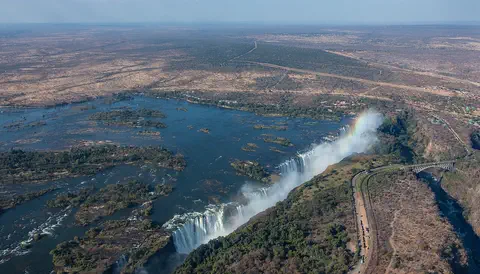
Photo: Diego Delso, CC BY-SA 4.0, via Wikimedia Commons
Discover Zambia
Zambia is a country in Africa.
It has no sea. Most of it is high, flat land with trees. A big river called the Zambezi flows along the south. The capital city is Lusaka.
Zambia is a landlocked country in south-central Africa. Most of it sits on a high plateau, 900 to 1,500 meters above the sea, cut by deep river valleys. It is named after the Zambezi River, which drains almost the whole country.
On a map, Zambia looks a little like a butterfly, because a wedge of land from its neighbor, the Democratic Republic of the Congo, pushes deep into it. It has eight neighbors. About 22 million people lived there in 2025, and many of them live along a railway that links the capital, Lusaka, with the mining towns of the Copperbelt.
Zambia is a landlocked state in south-central Africa on the high plateau of the region, 900–1,500 m above sea level, dissected by river valleys and rift troughs. It takes its name from the Zambezi, which drains all but a small northern part of the country. The Pedicle, a wedge of Congolese territory cutting deep into Zambia, gives it a distinctive butterfly shape.
Large parts of the country are thinly populated. Well over half the people live along the Line of Rail, the railway linking the Copperbelt with Lusaka and the border town of Livingstone. The World Bank put the population at 21,913,874 in 2025. Some two-fifths of Zambia's land is under some form of protection, and more than one-tenth is forest reserve.
Cities and famous places
Lusaka is the capital city.
In the north, people dig copper out of the ground. In the south is Victoria Falls, where a wide river falls down a deep crack. Its spray looks like smoke.
Lusaka, the capital, is the city where the most people live: about one in ten people in Zambia. North of it is the Copperbelt, the center of mining and industry.
In the south, the town of Livingstone stands near Victoria Falls, called Mosi-oa-Tunya. There the Zambezi drops into a deep gorge along a waterfall about 1.7 kilometers wide, and its spray can be seen 30 kilometers away. Downstream, Kariba Dam holds back Lake Kariba, a giant lake made by people that forms part of the border with Zimbabwe.
Lusaka holds the greatest concentration of people, about one-tenth of the population, and more than one-tenth live in the Copperbelt to its north, the country's industrial heart. Livingstone, near the falls, was the capital of Northern Rhodesia when the territory was formed in 1911.
Mosi-oa-Tunya / Victoria Falls, shared with Zimbabwe and inscribed by UNESCO in 1989, is about 1,708 m wide, averages 100 m deep with a deepest point of 108 m, and stands about 915 m above sea level; spray can be seen 30 km away on the Lusaka road. Below it the river has cut eight gorges in layered basalt. Lake Kariba, formed by the Kariba Dam (built in 1959) in a gorge on the middle Zambezi, now forms part of the border with Zimbabwe; a 600-megawatt power station on the Zambian side was completed in 1977, and another of 900 megawatts in the Kafue Gorge south of Lusaka.

Plateau, rifts and rainy seasons
Zambia has three seasons.
It is warm and rainy from November to April. Then it is cool and dry. Then it is hot and dry, until the rain comes back.
Zambia's highest land is in the east, where the Mafinga Hills rise to more than 2,100 meters. Deep valleys called rifts cut across the plateau; the Luangwa River flows along the bottom of one of them.
Zambia has three seasons. The warm, wet season lasts from November to April, with the heaviest rain in December and January. The cool, dry season runs from May to August, and July is usually the coldest month. Then comes the hot, dry season in September and October. Much of the country is covered by miombo woodland, small trees with grass beneath.
The plateau slopes generally southwest, yet the Zambezi turns east to the Indian Ocean. The Nyika Plateau on the Malawi border exceeds 1,800 m and the Mafinga Hills top 2,100 m; Lake Tanganyika lies about 600 m below the plateau, and the Luangwa occupies the largest rift trough. The continental divide between the Congo basin, draining to the Atlantic, and the Zambezi basin, draining to the Indian Ocean, runs along the border with the Democratic Republic of the Congo. The Bangweulu Swamps and Kafue Flats are wetlands of international importance.
Rain follows the intertropical convergence zone: the warm wet season (November to April) brings most of the year's precipitation, the cool dry season (May to August) brings occasional frost, and the hot dry season (September to October) usually holds the hottest month. Annual rainfall is under 800 mm in the driest region and over 1,000 mm in the wettest, sometimes above 1,400 mm in the northeast. Miombo woodland of Brachystegia and Julbernardia covers the plateau, with mopane woodland and baobabs in the hot Zambezi and Luangwa valleys and grassy dambos on the plateau.

Animals of Zambia
Fish eagles fly over Zambia's lakes and rivers.
Crocodiles rest by the water. Big shoebill birds live in a swamp. Elephants live in the national parks.
Zambia has many kinds of mammals, and big herds gather on the floodplains of its national parks, especially in the Luangwa and Kafue valleys. Poaching has made elephants much rarer, and rhinos almost disappeared. The African fish eagle, Zambia's national emblem, is common over large lakes and rivers, and crocodiles, tortoises and many lizards and snakes live there too.
In the Bangweulu Wetlands, people from nearby villages are paid to guard the nests of shoebills, large and unusual-looking wetland birds, day and night during the nesting season.
Britannica notes large concentrations of mammals on the major floodplains, particularly in the national parks of the Luangwa and Kafue valleys, but also depletion outside the parks and serious poaching within them: the illegal rhino-horn trade virtually eliminated the rhinoceros, and ivory poaching greatly reduced elephant numbers. The African fish eagle, Zambia's national emblem, is common on large stretches of open water; reptiles include crocodiles, tortoises and terrapins, and large termite mounds mark some landscapes.
The Bangweulu Wetlands, about 6,000 km² of papyrus swamp and floodplain, are the southern edge of the shoebill's range, with only a few hundred birds. African Parks, which manages this community-owned protected area, started a Shoebill Nest Protection Programme in 2012 that employs local community members to guard nests around the clock in the June–November nesting season, and in 2022 opened a facility to rear second chicks for release. The gorges below Victoria Falls are breeding sites for four endangered bird species.

People, languages and daily life
About 22 million people live in Zambia.
People speak many languages, like Bemba and Nyanja. English is used in schools and offices. Many families grow food on farms.
Most people in Zambia speak Bantu languages. The largest group, the Bemba, live in the north, and Bemba is the most widely spoken language. Nyanja is common in the east and in Lusaka, and Tonga in the south. In the west live the Lozi people, who have a king called the litunga. English is the official language.
In the countryside, most families farm or herd animals, and some make crafts to sell. In the cities, busy markets are places to shop, eat and meet friends. Most people in Zambia are Christian.
Most Zambians speak Bantu languages of the Niger-Congo family and descend from farming and metal-using peoples who settled in the region over the past 2,000 years. The Bemba group, more than one-fifth of the population, lives in the north-central provinces, and Bemba is the most widely spoken language and the lingua franca of the Copperbelt; Nyanja (Chewa) and Tonga groups together make up more than one-fifth. Nyanja is the lingua franca of Lusaka. The Lozi of the upper Zambezi floodplain are centralized under a king, the litunga. English is the official language.
Well over half the population lives along the Line of Rail, and rural-to-urban migration has dominated since independence. Most rural Zambians farm or herd, sometimes adding seasonal craftwork; city markets are social meeting places as well as places of trade. Zambia is predominantly Christian, more than three-fourths Protestant and one-fifth Roman Catholic, while the Asian community, mostly Gujarati-speaking Indians, is mainly Hindu or Muslim.

Kingdoms, copper and independence
People have lived in Zambia for a very long time.
Long ago, farmers came who knew how to make metal tools. Later, Britain ruled the land. In 1964, Zambia became its own country.
Over the past 2,000 years, farming peoples who made metal tools settled in Zambia. By the 1800s there were strong kingdoms, such as the Bemba kingdom in the north and the Lunda kingdom of Kazembe in the Luapula valley.
In the late 1800s Europeans began to arrive in large numbers, and a British company ran the land. In 1911 it became Northern Rhodesia, with its capital at Livingstone. Huge copper deposits were found deep underground, and by 1930 it was clear that copper was the land's most promising resource. In 1964 Zambia became independent, with Kenneth Kaunda as its first president.
Farming, metal-using Bantu-speaking peoples settled over the past two millennia, with influences from the upper Congo basin in the northeast and northwest; descendants of earlier hunter-gatherers live in the Kalahari margins, the Bangweulu and Lukanga swamps and the Kafue Flats. In the 19th century the Bemba built an extensive kingdom, the Lunda kingdom of Kazembe dominated the Luapula valley, the Ngoni settled in the east and the Kololo briefly ruled the Lozi.
The British South Africa Company joined its two territories as Northern Rhodesia in 1911 and handed it to the Colonial Office in 1924. Commercial copper mining dates from the 1920s, and by 1938 the territory was a major world producer. Zambia became independent in 1964 under Kenneth Kaunda (president 1964–91); copper prices rose until 1970 and Zambia became the world's third-largest producer. After Rhodesia's 1965 declaration of independence, Zambia rerouted its copper north, building a road and oil pipeline to Dar es Salaam, and China built a railway from the Copperbelt to Dar es Salaam in 1970–75. The University of Zambia was founded in 1965.
Zambia on the map
Find Zambia on the globe.
It is in southern Africa. It has no sea. Eight countries are all around it.
Zambia has eight neighbors. Angola is to the west, and the Democratic Republic of the Congo and Tanzania are to the north. Malawi is to the east, Mozambique to the southeast, and Zimbabwe, Botswana and Namibia to the south.
The Zambezi River and Lake Kariba form much of the southern border. In the far southwest, Zambia, Namibia, Botswana and Zimbabwe appear to meet at a single point.
Zambia has a long land border with Angola on the west and is divided from its southern neighbors by the Zambezi, with Lake Kariba forming part of the river border with Zimbabwe. At the eastern end of Namibia's Caprivi Strip, Zambia, Namibia, Botswana and Zimbabwe appear to meet at a quadripoint, though its exact nature is contested. Mozambique lies to the southeast, Malawi to the east and Tanzania to the northeast.
The long border with the Democratic Republic of the Congo runs from Lake Tanganyika to Lake Mweru, follows the Luapula River to the Pedicle, then the Zambezi–Congo watershed west to Angola. That watershed is also the continental divide between rivers draining to the Atlantic and to the Indian Ocean.
- Plateau height
- about 900 to 1,500 m above sea level
- Neighbors
- 8: Angola, DR Congo, Tanzania, Malawi, Mozambique, Zimbabwe, Botswana and Namibia
- Highest land
- Mafinga Hills, more than 2,100 m
- People (2025)
- 21,913,874
Amazing facts
-
Zambia is named after the Zambezi River.
Zambia takes its name from the Zambezi River, which drains almost all of the country.
Zambia is named after the Zambezi, which drains all but a small northern part of the country; the north drains to the Congo.
-
Zambia is shaped a bit like a butterfly.
A wedge of land from the Democratic Republic of the Congo cuts deep into Zambia, giving it a butterfly shape.
The Pedicle, a wedge of Congolese territory, cuts deep into Zambia to give the country its distinctive butterfly shape.
-
The spray from Victoria Falls can be seen from far away.
The spray from Victoria Falls can be seen 30 kilometers away on the road from Lusaka.
UNESCO reports that spray from the falls is visible 30 km away on the Lusaka road and 50 km away on the Bulawayo road in Zimbabwe.
-
People in Zambia guard the nests of a rare bird.
In the Bangweulu Wetlands, local people are hired to guard shoebill nests day and night during the nesting season.
African Parks' Shoebill Nest Protection Programme, begun in 2012, employs community members as 24-hour nest guardians; in one season 26 guardians watched 13 nests.
-
Zambia's emeralds are green gems.
Zambia has some of the largest emerald deposits in the world, mined near Luanshya and Ndola.
Britannica counts Zambia's emerald deposits among the world's largest; the stones are mined near Luanshya and Ndola and cut and polished locally.
Words to know
- plateau
- a large area of high, fairly flat land
- landlocked
- having no coastline; surrounded by land and other countries
- rift valley
- a long, deep valley formed where Earth's crust has pulled apart
- gorge
- a deep, narrow valley with steep rocky sides
- dam
- a wall built across a river to hold back water
- hydropower
- electricity made from moving water
- World Heritage Site
- a place UNESCO lists as important to all people, to be protected
Discovery challenge
-
What is the capital city of Zambia?
Which city is the capital of Zambia?
Which city, home to about one-tenth of Zambians, is the capital?
- Livingstone
- Kitwe
- Lusaka
Show the answer
Lusaka
Lusaka is the capital of Zambia.
Lusaka is the capital. Livingstone was the capital of Northern Rhodesia in 1911.
Lusaka has the greatest concentration of people, about one-tenth of the population.
-
Which river is Zambia named after?
Zambia takes its name from which river?
Which river, draining all but the north of the country, gives Zambia its name?
- The Nile
- The Zambezi
- The Niger
Show the answer
The Zambezi
Zambia is named after the Zambezi River.
The Zambezi drains almost all of Zambia and flows over Victoria Falls.
The Zambezi rises in northwestern Zambia and drains all but a small northern part, which belongs to the Congo basin.
-
What is the giant waterfall in Zambia called?
Which waterfall on the Zambezi is shared by Zambia and Zimbabwe?
Which waterfall, also called Mosi-oa-Tunya, did UNESCO inscribe in 1989?
- Niagara Falls
- Angel Falls
- Victoria Falls
Show the answer
Victoria Falls
Victoria Falls is the giant waterfall.
Victoria Falls, about 1,708 meters wide, is shared by Zambia and Zimbabwe.
Mosi-oa-Tunya / Victoria Falls is a transboundary World Heritage Site, inscribed in 1989.
-
What metal do miners dig up in Zambia?
Which metal is mined in Zambia's Copperbelt?
Which metal made Zambia the world's third-largest producer around 1970?
- Copper
- Silver
- Tin
Show the answer
Copper
Miners dig copper in Zambia.
The Copperbelt, north of Lusaka, is named after the copper mined there.
Copper prices rose from 1964 to 1970, when Zambia became the world's third-largest copper producer.
-
When did Zambia become its own country?
In which year did Zambia become independent?
In which year did Northern Rhodesia become independent as Zambia, under Kenneth Kaunda?
- 1911
- 1959
- 1964
Show the answer
1964
Zambia became its own country in 1964.
Zambia became independent in 1964, with Kenneth Kaunda as its first president.
Independence came in 1964; 1911 was the founding of Northern Rhodesia and 1959 the completion of Kariba Dam.
Places to discover in Zambia
-
Watch
Natural wonder
Victoria Falls
Victoria Falls, on the Zambezi River between Zambia and Zimbabwe, is about 1,708 meters wide and up to 108 meters deep. UNESCO calls it the largest curtain of falling water in the world, and its spray can be seen from tens of kilometers away.
-
 Watch
Natural wonder
River Congo
The Congo is Africa's second-longest river, about 4,700 kilometers long. It curves in a giant arc through the rainforests of central Africa and empties into the Atlantic Ocean. Rain falls in its basin all year, so it carries a huge amount of water, and its wild lower rapids are home to about 320 kinds of fish, about 90 of them found nowhere else.
-
 Watch
Natural wonder
Lake Tanganyika
Lake Tanganyika lies in a deep crack in Africa called a rift valley. Britannica calls it the longest freshwater lake in the world, and only Lake Baikal, in Russia, is deeper. Four countries share it: Tanzania, the Democratic Republic of the Congo, Burundi and Zambia. Its water is home to about 250 kinds of cichlid fish found nowhere else.
-
 Watch
Natural wonder
Great Rift Valley
The Great Rift Valley is a huge valley that runs through East Africa, where the continent is slowly being stretched and pulled apart. Long, steep cliffs line its sides, its floor holds lakes full of flamingos, and giant volcanoes such as Kilimanjaro and Mount Kenya rose beside it. Scientists think a new ocean may one day open here.
Animals of Zambia
-
 Watch
Animal
African fish eagle
The African fish eagle is a big eagle of Africa's lakes, rivers and coasts, with a white head, chest and tail and a chestnut-brown body. It snatches fish from the surface of the water, and its loud, ringing call is one of the best-known sounds of Africa.
-
 Watch
Animal
Shoebill
The shoebill is a tall gray bird of African swamps, named for its enormous bill shaped like a wooden shoe. It stands as still as a statue among the papyrus, then lunges forward to grab big, slippery fish such as lungfish.
Explore next
-
Watch
Natural wonder
Victoria Falls
Victoria Falls, on the Zambezi River between Zambia and Zimbabwe, is about 1,708 meters wide and up to 108 meters deep. UNESCO calls it the largest curtain of falling water in the world, and its spray can be seen from tens of kilometers away.
-
Watch
Animal
African fish eagle
The African fish eagle is a big eagle of Africa's lakes, rivers and coasts, with a white head, chest and tail and a chestnut-brown body. It snatches fish from the surface of the water, and its loud, ringing call is one of the best-known sounds of Africa.
-
Watch
Animal
Shoebill
The shoebill is a tall gray bird of African swamps, named for its enormous bill shaped like a wooden shoe. It stands as still as a statue among the papyrus, then lunges forward to grab big, slippery fish such as lungfish.
-
Watch
Natural wonder
Lake Tanganyika
Lake Tanganyika lies in a deep crack in Africa called a rift valley. Britannica calls it the longest freshwater lake in the world, and only Lake Baikal, in Russia, is deeper. Four countries share it: Tanzania, the Democratic Republic of the Congo, Burundi and Zambia. Its water is home to about 250 kinds of cichlid fish found nowhere else.
-
Watch
Natural wonder
River Congo
The Congo is Africa's second-longest river, about 4,700 kilometers long. It curves in a giant arc through the rainforests of central Africa and empties into the Atlantic Ocean. Rain falls in its basin all year, so it carries a huge amount of water, and its wild lower rapids are home to about 320 kinds of fish, about 90 of them found nowhere else.
-
 Watch
 Country
Malawi
Malawi is a narrow country in southeastern Africa that curves along the Great Rift Valley. Lake Malawi, one of the deepest lakes in the world, covers more than a fifth of the country, and it is home to hundreds of kinds of colorful fish. About 21 million people lived there in 2026.
-
 Watch
 Country
Democratic Republic of the Congo
The Democratic Republic of the Congo, or DR Congo, is the second-largest country in Africa. The mighty Congo River curves through its rainforests, volcanoes rise in the east, and its capital, Kinshasa, is a center of music, fashion and popular culture.
-
 Watch
 Country
Ethiopia
Ethiopia is a country on the Horn of Africa with no coast. Much of it is high, rugged land cut by the Great Rift Valley, it is one of the world's oldest countries, and more than 110 million people live there.
For parents & teachers
What children will learn
- Locate Zambia, its eight neighbors and the Zambezi River.
- Explain how Victoria Falls and Kariba Dam show the power of the Zambezi, and what hydropower is.
- Describe the peoples, languages and ways of life of Zambia without treating them as one culture.
- Outline Zambia's history from early farming peoples to Northern Rhodesia and independence in 1964.
Recommended ages: 3 to 17 · About 15 minutes
Talk about it
- Why do you think a country might build a giant dam across a river? What might change for people and animals?
- Why might local people be the best guards for the nests of a rare bird?
- How would your year be different if it rained almost only between November and April?
Try at home or in class
- Pour water slowly from a cup onto a tilted tray with a step in it, and watch the 'waterfall' and the spray, like a tiny Victoria Falls.
- On a map of your town, find a place about 1.7 kilometers from your home to picture how wide Victoria Falls is.
Key vocabulary: plateau, landlocked, rift valley, gorge, dam, hydropower, World Heritage Site
Where these facts come from
- Wikidata , Wikimedia Foundation (CC0 1.0)
- Natural Earth vector data , Natural Earth (NACIS) (Public domain)
- UNESCO World Heritage List , UNESCO World Heritage Centre (Linked as a reference; site facts come from Wikidata)
- Zambia (introduction, land, relief, drainage, soils) , Encyclopaedia Britannica
- Zambia: Climate (plant and animal life) , Encyclopaedia Britannica
- Zambia: People , Encyclopaedia Britannica
- Zambia: Religion (settlement patterns, daily life) , Encyclopaedia Britannica
- Zambia: Resources and power , Encyclopaedia Britannica
- Zambia: Colonial rule , Encyclopaedia Britannica
- Zambia: Zambia under Kaunda (1964–91) , Encyclopaedia Britannica
- Mosi-oa-Tunya / Victoria Falls , UNESCO World Heritage Centre
- Shoebill conservation in Bangweulu: a unique solution for a unique bird , African Parks
- Population, total: Zambia , World Bank
- PlayOwl region table, version 1 , PlayOwl (PlayOwl original data)
- flag-icons 7.5.0 , Panayiotis Lipiridis and contributors (MIT)
- Wikimedia Commons , Wikimedia Foundation (Per file (public domain, CC0, CC BY or CC BY-SA); see each media record)
Checked, not yet human-reviewed. Last updated October 27, 2026. Spotted a mistake? Tell us.
Picture credits
- Photo: Diego Delso, CC BY-SA 4.0, via Wikimedia Commons · source · license
- Photo: Matthew Grollnek, CC BY-SA 4.0, via Wikimedia Commons · source · license
- Photo: Rhys Jones, CC BY 2.0, via Wikimedia Commons · source · license
- Photo: Voidoffrogs, CC0 1.0, via Wikimedia Commons · source · license
- Photo: cowbridgeguide.co.uk, CC BY 3.0, via Wikimedia Commons · source · license
- Photo: © Hans Hillewaert, CC BY-SA 3.0, via Wikimedia Commons · source · license
- Photo: Charles J. Sharp, CC BY-SA 4.0, via Wikimedia Commons · source · license