
 Country
Europe
Montenegro
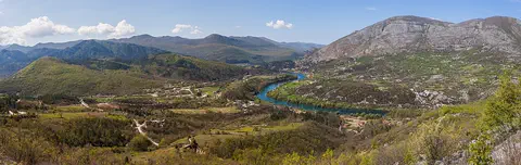
Montenegro is a small country by the Adriatic Sea. Its name means Black Mountain, and it has steep mountains, deep canyons and a winding bay.
Montenegro is a small country in the Balkans, on the Adriatic Sea. High, rocky mountains rise right behind its narrow coast, the Tara River has cut Europe's deepest gorge, and about 624,000 people lived there at the 2023 census.
Montenegro lies at the southern end of the Dinaric Alps, where a narrow Adriatic coastal plain gives way to limestone karst and some of the most rugged, ice-carved mountains in Europe. Its 2023 census counted 623,633 people, and it has been an independent state since 2006.
Photo: Milos58, CC BY-SA 3.0, via Wikimedia Commons
Discover Montenegro
Montenegro is a small country in Europe.
It has a sunny coast on the sea. Big rocky mountains rise behind it. Its name means Black Mountain.
Montenegro is a small country in the Balkans, the big peninsula in southeastern Europe. It lies on the Adriatic Sea, but its coastal plain is only 2 to 6 kilometers wide. Behind it rise dry limestone hills and some of the most rugged mountains in Europe.
Both of its names, Montenegro and Crna Gora, mean "Black Mountain," after Mount Lovćen near the coast. Podgorica is the capital, and the older city of Cetinje is its cultural center. The 2023 census counted about 624,000 people.
Montenegro lies in the west-central Balkans at the southern end of the Dinaric Alps. Its terrain runs from high mountains along the borders with Kosovo and Albania, through a segment of the limestone Karst region, to a coastal plain only 2–6 km wide that disappears entirely where Mount Lovćen and other peaks rise straight from the Gulf of Kotor.
The names Montenegro (from Venetian Italian) and Crna Gora both mean "Black Mountain," after Lovćen (1,749 m), the historical heartland's stronghold. Podgorica is the administrative capital and Cetinje, the old royal capital, the cultural center. Montenegro's Statistical Office (MONSTAT) counted 623,633 usual residents in the census of December 2023, on an area of 13,883 km².
Cities and famous places
Podgorica is the capital city.
Two rivers meet there. Kotor is an old town on a long, winding bay. Steep mountains rise all around the water.
Podgorica, the capital, stands near where the Ribnica and Morača rivers meet. In Roman times a caravan stop stood here, and the city has been called Podgorica since 1326. About 179,500 people lived in the Capital City of Podgorica in 2023, more than a quarter of everyone in Montenegro.
Kotor lies on the Bay of Kotor, a winding, fjordlike inlet of the sea, with mountains rising steeply to nearly 1,500 meters. In the Middle Ages it was an important trading and artistic town, with famous schools of stonemasonry and icon painting. Cetinje, high in the limestone hills, was once the capital.
Podgorica began as Birziminium, a Roman caravan stop; as a medieval capital it was called Ribnica, and it has been Podgorica since 1326. It passed to the Ottomans in 1474 and back to Montenegro in 1878. Almost all of the old city was destroyed in World War II; it was named Titograd after the Yugoslav leader Josip Broz Tito in the postwar period and took back its old name in 1992. The University of Montenegro dates from 1974. In MONSTAT's 2023 census the Capital City of Podgorica had 179,505 residents, close to 28.78 percent of the national total.
The Natural and Culturo-Historical Region of Kotor, a World Heritage Site since 1979, covers 14,600 ha of the inner bay, where two bays are ringed by mountains rising to nearly 1,500 m. UNESCO describes Kotor and its neighbors as the main bridgeheads of Venice on the southern Adriatic, with famous schools of masonry, iconography and goldsmithing. An earthquake in 1979 badly damaged many monuments, including four Romanesque churches and the town walls; they were restored, largely with UNESCO's help.
Black mountains and a karst land
Montenegro has many high mountains.
The Tara River runs through a very deep canyon. Lake Skadar is the biggest lake. In the mountains it rains and snows a lot.
Much of Montenegro is karst: limestone rock that slowly dissolves in water, making sinkholes and caves. Much of the rainwater there flows through underground channels instead of on the surface. Montenegro's biggest lake, Lake Skadar, fills a karst hollow near the coast and stretches into Albania.
In the north, the mountains of Durmitor were carved by glaciers. Bobotov Kuk rises to 2,522 meters, and the Tara River has cut a gorge more than 60 kilometers long, the deepest in Europe. The mountains are very wet: Crkvice, above the Bay of Kotor, gets nearly 5,100 millimeters of rain and snow a year.
Montenegro's karst lies mostly at about 900 m, its predominantly limestone rock dissolving into sinkholes and caves; much of its drainage runs underground. The Zeta valley around Nikšić Polje is a typical flat-floored karst depression. Lake Skadar, the largest lake, occupies a karst polje whose floor lies below sea level; Britannica gives it 40 km by 16 km and 360 km², about three-fifths inside Montenegro. In the north the Lim and Tara drain toward the Danube via the Drina, while southern streams flow to the Adriatic.
The high mountains average more than 2,000 m and were the most ice-eroded part of the Balkan Peninsula in the last glacial period. MONSTAT's list of peaks, from the Cadastre and State Property Administration, is headed by Bobotov kuk in Durmitor and Maja Rozit in the Prokletije, each 2,522 m. UNESCO calls the Tara River Gorge, more than 60 km long, Europe's deepest. Lower areas have a Mediterranean climate with dry summers and mild, rainy winters; Podgorica averages 27 °C in July, Crkvice receives nearly 5,100 mm of precipitation a year, and snow lies for about 120 days in the higher mountains.
Animals of Montenegro
Brown bears and wolves live in the mountains.
Wildcats live there too. Golden eagles soar over the peaks. Otters swim in the rivers.
Few people live in much of Montenegro, and it is home to bears, deer, martens and wild pigs. Wolves, foxes and wildcats hunt there too. About one-third of the country, mostly in the high mountains, is still covered with broad-leaved forest.
In Durmitor National Park, brown bears, gray wolves, European wildcats and river otters live among the peaks, and about 130 kinds of birds have been recorded, including golden eagles and capercaillie. Some European black pines there are 400 years old and taller than 50 meters, and the rare Danube salmon still swims in the park's rivers.
Britannica describes sparsely populated Montenegro as habitat for bears, deer, martens and wild pigs (Sus scrofa), with predators including wolves, foxes and wildcats, and a rich variety of birds, reptiles and fish. About one-third of the country, mainly the high mountains, keeps its broad-leaved forest; the southern karst, once forested with oak and cypress, lost its trees to fuel and building, eroded, and is now largely bare rock and maquis scrub.
Durmitor National Park, founded in 1952 and inscribed by UNESCO in 1980, spans altitudes from about 450 to more than 2,500 m. UNESCO records about 700 vascular plant species, 37 endemic to the wider area and six to Durmitor alone, and an old-growth stand of European black pine in which 400-year-old trees exceed 50 m. Large mammals include the brown bear, gray wolf, European wildcat and river otter; some 130 bird species include golden and short-toed eagles, peregrine falcon, capercaillie and black grouse. The endangered Danube salmon, under heavy pressure from overuse and dam building elsewhere in its range, survives in the park's rivers.
People, languages and ways of life
About 624,000 people live in Montenegro.
Many live in Podgorica. Some live in villages of stone houses. In the hills, many farmers keep sheep.
The 2023 census counted about 624,000 people. More than three-fifths live in towns and cities, and Podgorica is by far the largest. In the census, about 41 percent of people said they were Montenegrins and about 33 percent Serbs, and Bosniaks, Albanians and other groups live there too.
Montenegrin is the official language, and the constitution also recognizes Serbian, Bosnian, Albanian and Croatian. Villages often sit in flat karst hollows, with houses built of stone. In the uplands, the main kind of farming is raising sheep. Montenegro has used the euro since 2002.
MONSTAT's 2023 census counted 623,633 people, 50.80 percent of them women, with an average age of 39.73. Answering by free self-declaration, 41.12 percent declared themselves Montenegrins, 32.93 percent Serbs, 9.45 percent Bosniaks and 4.97 percent Albanians. Britannica notes that differences between Montenegrin and Serb identity remain a matter of controversy and that the census shares have shifted over time. Bosniaks live mainly in the northern mountains and Albanians along the coast; nearly three-fourths of Ulcinj's people are Albanian.
Montenegrin is the official language, and the constitution also recognizes Serbian, Bosnian, Albanian and Croatian. In the census, 43.18 percent gave Serbian and 34.52 percent Montenegrin as their mother tongue. Religious affiliation was 71.10 percent Orthodox, 19.99 percent Islam and 3.27 percent Catholic. Less than two-fifths of people now live in rural areas, compared with about seven-eighths in the 1940s; villages lie mainly in karst poljes, houses are often built of stone without mortar, and sheepherding is the main upland farming. The euro has been the official currency since 2002.
A long history
People have lived here for a very long time.
Long ago, people from Greece built towns on the coast. Later, Montenegro had its own princes and kings. In 2006 it became its own country again.
Before Slavic peoples arrived in the 500s and 600s, the land was home mainly to people called Illyrians. Greek colonies grew up on the coast in the 600s and 500s BCE, and the Romans took over in the year 9. In the 1490s a printing press at Cetinje produced some of the earliest books in the Cyrillic alphabet.
For centuries Montenegro was led by prince-bishops and then princes. In 1878 an international treaty almost doubled its area and gave it towns on the sea, and in 1910 its prince took the title of king. In 1918 Montenegro joined a new kingdom that later became Yugoslavia. In 2006 its people voted for independence, and Montenegro became a country of its own.
Illyrians were the main inhabitants before the Slavs arrived in the 6th and 7th centuries CE. Greek colonies were founded on the coast in the 7th and 6th centuries BCE, Celts settled in the 4th century BCE, and Rome annexed the Illyrian kingdom based at Skadar in 9 CE. Mihailo of Duklja, the first ruler of Zeta to claim the title of king, received it in 1077 from Pope Gregory VII. Under the Crnojević dynasty a monastery and bishopric were founded at Cetinje, and a press imported from Venice printed some of the earliest Cyrillic books after 1493. From 1516 prince-bishops (vladikas) ruled; Montenegro was almost constantly at war with the Ottoman Empire, which formally recognized its independence in 1799, and Britannica notes that alone among the Balkan states it was never subjugated.
The Congress of Berlin (1878) nearly doubled its area and gave it the ports of Bar and Ulcinj; Nicholas I took the title of king in 1910. In December 1918 Montenegro entered the Kingdom of Serbs, Croats and Slovenes (Yugoslavia from 1929), and after World War II it became a republic within Yugoslavia. After Yugoslavia broke up it formed a federation with Serbia in 1992, renamed Serbia and Montenegro in 2003. In a referendum on May 21, 2006, 55.5 percent voted to end the union, just over the 55 percent threshold; Montenegro declared independence on June 3, 2006, and Serbia's parliament recognized it two days later. It joined NATO on June 5, 2017.
Montenegro on the map
Find Montenegro on the globe.
It is in Europe, beside the Adriatic Sea. Mountains cover most of it. High mountains rise close behind its coast.
Montenegro is in the Balkans, on the Adriatic Sea. Its neighbors include Croatia, Bosnia and Herzegovina, Serbia and Albania. Lake Skadar, its largest lake, is shared with Albania.
The country is small: about 13,900 square kilometers. Its coast is about 290 kilometers long, and the narrow, winding Bay of Kotor reaches deep inland between steep mountains.
Britannica describes Montenegro as bounded by the Adriatic Sea and Croatia to the southwest, Bosnia and Herzegovina to the northwest, Serbia to the northeast, Kosovo to the east and Albania to the southeast. Montenegro recognized Kosovo's independence in 2008, which Britannica notes troubled its relations with Serbia.
MONSTAT, using Cadastre and State Property Administration data, gives the area as 13,883 km² (the difference between the national total and the municipalities' sum is Montenegro's share of Lake Skadar) and the coastline as 293.5 km; Britannica gives about 240 km of seacoast. The Gulf of Kotor, a fjordlike inlet, has four bays linked by narrow straits, and the port of Bar is the country's only maritime port.
- Area (MONSTAT)
- 13,883 km²
- Coastline (MONSTAT)
- 293.5 km
- Highest listed peaks (MONSTAT)
- Bobotov kuk and Maja Rozit, 2,522 m each
- Coastal plain
- 2 to 6 km wide
- People (2023 census)
- 623,633
Amazing facts
-
Montenegro means Black Mountain.
Both of the country's names, Montenegro and Crna Gora, mean "Black Mountain," after Mount Lovćen near the coast.
Montenegro (from Venetian Italian) and Crna Gora both mean "Black Mountain," referring to Mount Lovćen (1,749 m), the historical heartland's stronghold.
-
A river here made a very, very deep canyon.
The Tara River Gorge in Durmitor National Park is more than 60 kilometers long and the deepest gorge in Europe.
UNESCO describes the Tara River Gorge, more than 60 km long, as Europe's deepest gorge and one of very few unaffected by dams and roads.
-
It rains and snows a lot in some mountains here.
Crkvice, in the hills above the Bay of Kotor, gets nearly 5,100 millimeters of rain and snow a year.
Annual precipitation at Crkvice, in the karst above the Gulf of Kotor, is nearly 5,100 mm, while Podgorica, near sea level, has the warmest July in the country, averaging 27 °C.
-
Some pine trees here are very old and very tall.
In Durmitor National Park, some European black pines are 400 years old and more than 50 meters tall.
Durmitor's old-growth European black pine forest includes 400-year-old trees taller than 50 m.
-
Old books were printed here long ago.
In the 1490s a printing press at Cetinje produced some of the earliest books in the Cyrillic alphabet.
Djuradj Crnojević imported a printing press from Venice that produced, after 1493, some of the earliest books in the Cyrillic script.
Words to know
- karst
- land made of limestone that dissolves in water, full of sinkholes, caves and underground streams
- polje
- a large flat-floored hollow in karst country
- gorge
- a deep, narrow valley with steep rocky sides, usually cut by a river
- fjordlike inlet
- a long, narrow arm of the sea between steep mountains
- glacial lake
- a lake in a hollow carved by a glacier
- referendum
- a vote in which all citizens decide a single question
- census
- an official count of all the people living in a country
Discovery challenge
-
What is the capital city of Montenegro?
Which city is the capital of Montenegro?
Which city is Montenegro's administrative capital, while Cetinje is its cultural center?
- Cetinje
- Kotor
- Podgorica
Show the answer
Podgorica
Podgorica is the capital. Two rivers meet there.
Podgorica is the capital. Cetinje is the old capital, and Kotor is a historic town on the bay.
Podgorica is the administrative capital; Cetinje, the old royal capital, is the cultural center.
-
What does the name Montenegro mean?
What do the names Montenegro and Crna Gora mean?
What do both Montenegro and Crna Gora mean, in reference to Mount Lovćen?
- Black Mountain
- Blue Sea
- Green Valley
Show the answer
Black Mountain
Montenegro means Black Mountain.
Both names mean "Black Mountain," after Mount Lovćen near the coast.
Montenegro (Venetian Italian) and Crna Gora both mean "Black Mountain," referring to Mount Lovćen (1,749 m).
-
Which sea is next to Montenegro?
Montenegro's coast lies on which sea?
Which sea does Montenegro's 293.5 km coastline face?
- The Baltic Sea
- The Adriatic Sea
- The Red Sea
Show the answer
The Adriatic Sea
Montenegro is beside the Adriatic Sea.
Montenegro lies on the Adriatic Sea, and the Bay of Kotor winds in from it between steep mountains.
Montenegro faces the Adriatic; MONSTAT gives 293.5 km of coastline, while Britannica gives about 240 km.
-
The Tara River made a very deep canyon. It is the deepest in which part of the world?
The Tara River Gorge is the deepest gorge on which continent?
UNESCO calls Durmitor's Tara River Gorge the deepest gorge on which continent?
- Europe
- Africa
- South America
Show the answer
Europe
It is the deepest canyon in Europe.
The Tara River Gorge, more than 60 kilometers long, is Europe's deepest.
UNESCO describes the Tara River Gorge, over 60 km long, as Europe's deepest gorge and one of very few unaffected by dams and roads.
-
In which year did Montenegro become its own country again?
In which year did Montenegro become independent?
In which year did a referendum end the union of Serbia and Montenegro?
- 1806
- 1956
- 2006
Show the answer
2006
Montenegro became its own country in 2006.
In 2006 Montenegro's people voted for independence.
On May 21, 2006, 55.5 percent voted to end the union, just above the 55 percent threshold; independence was declared on June 3.
Animals of Montenegro
-
 Watch
3D
Animal
Brown bear
The brown bear lives in more places than any other bear, from European forests to the mountains of Asia and the rivers of Alaska. It eats almost anything, from berries to salmon, and spends the long winter asleep in a cozy den. Grizzly bears and Kodiak bears are brown bears too.
-
 Watch
3D
Animal
Gray wolf
The gray wolf is the largest member of the dog family and the wild ancestor of pet dogs. Wolves live in family packs that hunt big animals like elk and moose together, and their howls can carry about 10 kilometers. After being wiped out in many places, wolves are coming back in parts of North America and Europe.
-
 Watch
Animal
Golden eagle
The golden eagle is one of the largest and fastest birds of prey in North America, and it lives across much of the Northern Hemisphere. It soars over mountains and open country on wings more than two meters wide and dives at tremendous speed to catch rabbits, hares and ground squirrels.
Explore next
-
Watch
3D
Animal
Brown bear
The brown bear lives in more places than any other bear, from European forests to the mountains of Asia and the rivers of Alaska. It eats almost anything, from berries to salmon, and spends the long winter asleep in a cozy den. Grizzly bears and Kodiak bears are brown bears too.
-
Watch
3D
Animal
Gray wolf
The gray wolf is the largest member of the dog family and the wild ancestor of pet dogs. Wolves live in family packs that hunt big animals like elk and moose together, and their howls can carry about 10 kilometers. After being wiped out in many places, wolves are coming back in parts of North America and Europe.
-
Watch
Animal
Golden eagle
The golden eagle is one of the largest and fastest birds of prey in North America, and it lives across much of the Northern Hemisphere. It soars over mountains and open country on wings more than two meters wide and dives at tremendous speed to catch rabbits, hares and ground squirrels.
- Watch Geography Caves and karst landscapes Most caves are made by slightly acidic water slowly dissolving rock such as limestone. Over hundreds of thousands of years, cracks grow into tunnels and rooms. The land above, with its sinkholes, disappearing streams and springs, is called karst. Inside, dripping water builds stalactites and stalagmites.
-
 Watch
 Country
Belarus
Belarus is a landlocked country in eastern Europe. Ice sheets of the last ice age shaped its low hills and wide plains, it has more than 10,000 lakes and one of Europe's largest wetlands, and about 9.1 million people lived there in 2025.
-
 Watch
 Country
Bosnia and Herzegovina
Bosnia and Herzegovina is a mountainous country in southeastern Europe. It has forests, limestone hills and many rivers, and famous old stone bridges cross some of them. Its capital is Sarajevo. It touches the Adriatic Sea along only about 20 kilometers of coast.
-
 Watch
 Country
Bulgaria
Bulgaria is a country on the eastern side of the Balkan Peninsula, with the Danube River to the north and the Black Sea to the east. Mountains cross it from west to east, and about 6.4 million people lived there at the end of 2025.
-
 Watch
 Country
Croatia
Croatia is a crescent-shaped country in southeastern Europe. Its long coast on the Adriatic Sea is fringed by more than 1,100 islands, limestone mountains rise behind it, fertile plains lie in the north, and about 3.87 million people lived there in mid-2025.
For parents & teachers
What children will learn
- Locate Montenegro on the Adriatic and describe its coast, karst and high mountains.
- Explain how water dissolving limestone creates karst landscapes with sinkholes, caves and underground rivers.
- Name some of its wildlife and ways of life without treating its people as one single culture.
- Outline its history from Greek coastal colonies to independence in 2006.
Recommended ages: 3 to 17 · About 15 minutes
Talk about it
- Why might people build villages in the flat hollows of a rocky karst landscape?
- What makes a place like the Tara River Gorge worth protecting from dams?
- Montenegro's coast is only a few kilometers wide before the mountains. How might that shape where roads and towns go?
Try at home or in class
- Put a sugar cube on a plate and drip water on it with a spoon to see how water can dissolve rock-like material, as rain slowly does to limestone.
- On a map of Europe, find the Adriatic Sea and trace Montenegro's coast and the Bay of Kotor.
Key vocabulary: karst, polje, gorge, fjordlike inlet, glacial lake, referendum, census
Where these facts come from
- Wikidata , Wikimedia Foundation (CC0 1.0)
- Natural Earth vector data , Natural Earth (NACIS) (Public domain)
- UNESCO World Heritage List , UNESCO World Heritage Centre (Linked as a reference; site facts come from Wikidata)
- Montenegro (introduction, relief, drainage, soils, climate, plant and animal life) , Encyclopaedia Britannica
- Montenegro: People , Encyclopaedia Britannica
- Montenegro: History , Encyclopaedia Britannica
- Montenegro: Modernization and statehood , Encyclopaedia Britannica
- Montenegro: Federation with Serbia , Encyclopaedia Britannica
- Montenegro: Independence , Encyclopaedia Britannica
- Podgorica , Encyclopaedia Britannica
- Gulf of Kotor , Encyclopaedia Britannica
- Statistical Yearbook 2022, Chapter 1: Geography , Statistical Office of Montenegro (MONSTAT)
- The 2023 Census of Population, Households, and Dwellings: Population of Montenegro by Sex and Age (Release 133/2024) , Statistical Office of Montenegro (MONSTAT)
- The 2023 Census: Population by National Affiliation, Religion, Mother Tongue and Language Usually Spoken (Release 135/2024) , Statistical Office of Montenegro (MONSTAT)
- Natural and Culturo-Historical Region of Kotor , UNESCO World Heritage Centre
- Durmitor National Park , UNESCO World Heritage Centre
- PlayOwl region table, version 1 , PlayOwl (PlayOwl original data)
- flag-icons 7.5.0 , Panayiotis Lipiridis and contributors (MIT)
- Wikimedia Commons , Wikimedia Foundation (Per file (public domain, CC0, CC BY or CC BY-SA); see each media record)
Checked, not yet human-reviewed. Last updated October 24, 2026. Spotted a mistake? Tell us.