 Country
Europe
Bosnia and Herzegovina
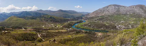
Bosnia and Herzegovina is a country in Europe with mountains, forests and many rivers. It has very old stone bridges.
Bosnia and Herzegovina is a mountainous country in southeastern Europe. It has forests, limestone hills and many rivers, and famous old stone bridges cross some of them. Its capital is Sarajevo. It touches the Adriatic Sea along only about 20 kilometers of coast.
Bosnia and Herzegovina, in the western Balkan Peninsula, is a largely mountainous country of 51,209 km² crossed by the Dinaric Alps, with a karst region in the south and only about 20 km of Adriatic coastline. Its population was 3,531,159 at the 2013 census; the World Bank estimated about 3.14 million in 2025.
Photo: Diego Delso, CC BY-SA 3.0, via Wikimedia Commons
Discover Bosnia and Herzegovina
Bosnia and Herzegovina is a country in Europe.
It has two parts in its name. Bosnia is in the north and middle. Herzegovina is in the south. There are lots of mountains and rivers. The capital city is Sarajevo.
Bosnia and Herzegovina is a country in the western part of the Balkan Peninsula, in southeastern Europe. Its long name joins two old regions: Bosnia covers the north and center, and Herzegovina covers the south and southwest.
Most of the country is mountains, with forests, rivers and rocky limestone plateaus. Its capital is Sarajevo. Only a tiny strip of land, about 20 kilometers long, reaches the Adriatic Sea. More than 3 million people live there.
Bosnia and Herzegovina occupies 51,209 square kilometers of the western Balkan Peninsula. Britannica describes it as roughly triangular, bordered by Croatia on the north, west and south, Serbia on the east and Montenegro on the southeast, with a narrow extension reaching the Adriatic Sea. The historical region of Bosnia covers the north and center, Herzegovina the south and southwest.
These historical regions are not the same as the country's two political entities, set up by the Dayton Accords of 1995: the Republika Srpska in the north and east and the Federation of Bosnia and Herzegovina in the west and center. The capital is Sarajevo; Mostar and Banja Luka are important regional cities. The last census, in 2013, counted 3,531,159 people, and the World Bank estimated 3,140,095 in 2025.
Cities and famous bridges
Sarajevo is the capital city.
Many people live and work there. In the town of Mostar, an old stone bridge curves over a river. Another long stone bridge in Višegrad has many arches.
Sarajevo is the capital. After 1448, the Ottomans built up a settlement called Vrhbosna into the city of Sarajevo. In 1984 the Winter Olympic Games were held there.
The town of Mostar is known for its Old Bridge, Stari Most, a stone arch over the Neretva River. The name comes from the bridge keepers, called mostari. The bridge you can see today was rebuilt in 2004 to match the old one. In the east, the Mehmed Paša Sokolović Bridge at Višegrad crosses the Drina River on 11 stone arches.
Ottoman forces took the settlement of Vrhbosna in 1448 and developed it into the city of Sarajevo, the capital today; travelers in the Ottoman period described its fountains, bridges, schools and libraries, and in 1984 it hosted the Winter Olympics. UNESCO notes that Mostar's name, first recorded in 1474, comes from the mostari, the bridge keepers. Its Old Bridge, designed by the architect Hajruddin following the design of his teacher, Mimar Sinan, was destroyed in the conflict of the 1990s and rebuilt in 2004; the Old Bridge Area became a World Heritage Site in 2005, which UNESCO calls a symbol of reconciliation and of coexisting communities.
The Mehmed Paša Sokolović Bridge in Višegrad, built at the end of the 16th century by the court architect Mimar Koca Sinan on the orders of the grand vizier whose name it carries, is 179.5 m long with 11 masonry arches spanning 11 to 15 m. It was inscribed in 2007.

Mountains, karst and rivers
Bosnia and Herzegovina has many mountains.
The tallest one is called Maglić. In the south, the hills are made of limestone rock. Some rivers there flow under the ground! Other big rivers flow north to the Sava River.
Mountain ranges run across the country from northwest to southeast, and the Dinaric Alps rise along the western border. The highest peak is Maglić, 2,386 meters tall, near the border with Montenegro.
In the south lies the Karst, a region of dry limestone plateaus full of caves and holes, where rivers flow mostly underground. Between the ridges are hollows called poljes, with soil good for farming. Big rivers such as the Bosna, Vrbas and Una flow north into the Sava River, while the Neretva turns southwest through the Karst toward the sea.
The terrain is largely mountainous. The Dinaric Alps dominate the western border, and ranges such as the Kozara, Vlašić, Grmeč and Raduša run northwest to southeast; Maglić, near the Montenegrin border, reaches 2,386 m. The Karst of the south and southwest is a region of arid limestone plateaus with caves, potholes and underground drainage; its uplands are often bare, but poljes between the ridges hold alluvial soil suitable for farming. Fault lines are widespread, and in 1969 an earthquake destroyed 70 percent of the buildings in Banja Luka.
The Sava, a tributary of the Danube, forms the northern border; the Bosna, Vrbas and Una flow north into it, and the Drina forms part of the border with Serbia. The Neretva turns sharply southwest through the Karst to the Adriatic. The Dinaric Alps largely cut the country off from Mediterranean weather: in Banja Luka, January averages about 0 °C and July about 22 °C, while Mostar averages about 6 °C in January and 26 °C in July.
Forests and wildlife
Forests cover a big part of the land.
Bears and wolves live in the wild here. Otters and foxes live here too. Lots of plums grow in this country.
About two-fifths of Bosnia and Herzegovina is covered with forests of pine, beech and oak. They are home to bears, wolves, wild pigs, wildcats, foxes, badgers and otters, and there are falcons too.
Another wild animal here is the chamois, which looks a little like a goat. The country also has large national parks, such as Sutjeska, Kozara and Una, and nature reserves. Plums, grapes, apples and pears are common fruits.
Britannica describes about two-fifths of the country as forested with pine, beech and oak, and lists a rich wildlife that includes bears, wolves, wild pigs, wildcats, chamois (goatlike animals), otters, foxes, badgers and falcons. The country has large national parks, Sutjeska, Kozara and Una, as well as nature reserves, and its mountains and open spaces are used for hiking and skiing.
The karst rivers are a special feature: in the south, much of the water flows through underground channels in the limestone, and the country is rich in natural springs, many of them tapped for bottled mineral water or thermal spas. Grapes, apples, pears and especially plums are common fruits.

People, languages and food
More than 3 million people live in Bosnia and Herzegovina.
People speak Bosnian, Croatian and Serbian. They can understand each other. The national dish is ćevapi, small grilled rolls of meat in bread.
Bosnia and Herzegovina has three official languages: Bosnian, Croatian and Serbian. They are so close that speakers understand each other, and they can be written in two alphabets, the Latin one and Cyrillic.
The three largest groups of people are Bosniaks, Serbs and Croats. In the old town of Mostar, mosques, churches and synagogues stood side by side. Coffeehouses are popular meeting places. Foods include stuffed vegetables and sweet baklava-style cakes, and the national dish is ćevapi, small grilled rolls of meat served in bread. Plums are made into thick jam.
The three largest groups are the Bosniaks, Serbs and Croats, who share a South Slav heritage; Britannica estimates Bosniaks at more than two-fifths of the population, Serbs at roughly one-third and Croats at less than one-fifth. Islam, Orthodox Christianity and Roman Catholicism are all practiced, generally corresponding to those three groups. Most people's mother tongue is one of the mutually intelligible languages now called Bosnian, Croatian or Serbian, written in Latin or Cyrillic letters.
About half of the population lives in rural areas. Cultural life mixes European and Turkish influences: kafane (traditional coffeehouses) and modern café-bars are meeting places, and the cuisine includes stuffed vegetables, coffee, baklava-type cakes and ćevapi, grilled rolls of seasoned ground meat. Ivo Andrić, born in Bosnia, won the 1961 Nobel Prize for Literature; his novels, such as The Bridge on the Drina (1945), are concerned with the history of Bosnia. Almost every village has a football field.

A long history
People have lived here for a very long time.
Long ago, Romans ruled this land. Later there was a kingdom of Bosnia. Builders made beautiful stone bridges more than 400 years ago. Today Bosnia and Herzegovina is its own country.
More than 2,000 years ago, the Romans made this land part of their empire. Slavs settled here in the 500s and 600s. From 1180 to 1463, a Bosnian state existed for most of the time, and for a short time in the late 1300s it was the strongest state in the western Balkans.
In 1463 most of Bosnia became part of the Ottoman Empire, and cities such as Sarajevo and Mostar grew, with fountains, bridges, schools and mosques. Austria-Hungary took control in 1878. In 1918 the land became part of a new kingdom, and later it was one of the republics of Yugoslavia. In 1992 most voters chose independence.
When Rome extended its conquests here in the 2nd and 1st centuries BCE, the people were mainly Illyrian tribes; most of modern Bosnia became part of the province of Dalmatia. Slavs settled from the 6th century. A Bosnian state existed for most of the period from 1180 to 1463, strongest under Ban Kulin, Stjepan Kotromanić and King Tvrtko I. Ottoman armies conquered most of Bosnia in 1463, and a large part of the population gradually converted to Islam; it took more than a hundred years for Muslims to become a majority. Medieval tombstones called stećci, from the 12th to 16th centuries, are a World Heritage Site shared with Croatia, Montenegro and Serbia (2016).
Austria-Hungary took control in 1878. In 1918 the land joined the Kingdom of Serbs, Croats and Slovenes, and after World War II it became a republic of socialist Yugoslavia. When Yugoslavia broke up, most voters chose independence in a 1992 referendum, which much of the Serb population boycotted. War followed from 1992 until the internationally brokered Dayton Accords of late 1995, which ended it and created the present decentralized state with two entities.
Bosnia and Herzegovina on the map
Find Bosnia and Herzegovina on the globe.
It is in Europe. Its shape looks a bit like a triangle. It has three neighbors: Croatia, Serbia and Montenegro. A tiny piece touches the sea.
Bosnia and Herzegovina is in southeastern Europe, on the Balkan Peninsula. Its shape is roughly a triangle. Croatia wraps around it on the north, west and south, Serbia lies to the east and Montenegro to the southeast.
In the southwest, a narrow strip of land reaches the Adriatic Sea, with only about 20 kilometers of coast. The Sava River runs along the northern border, and the Drina forms part of the eastern border.
The country lies in the western Balkans, at roughly 44° N and 18° E. Croatia borders it on the north, west and south, Serbia on the east and Montenegro on the southeast. Its Adriatic coastline is only about 20 km long, bounded by Croatia on both sides, and Britannica notes it has no natural harbors.
The Sava, a Danube tributary, marks the northern boundary with Croatia, and the Drina part of the eastern boundary with Serbia. Inside the country, the two entities created at Dayton in 1995 divide the map differently from the historical regions: the Republika Srpska lies in the north and east, and the Federation of Bosnia and Herzegovina occupies the west and center.
- Area
- 51,209 km²
- Coastline
- about 20 km, on the Adriatic Sea
- Highest point
- Maglić, 2,386 m
- Neighbors
- Croatia, Serbia, Montenegro
Amazing facts
-
The town of Mostar is named after its bridge keepers.
Mostar's name comes from the mostari, the keepers of its bridge. The name was first written down in 1474.
UNESCO notes that the name Mostar, first recorded in 1474, derives from the mostari, the bridge keepers who guarded the river crossing.
-
Bosnia and Herzegovina has only a tiny bit of seaside.
The country's coast on the Adriatic Sea is only about 20 kilometers long, with Croatia on both sides.
The Adriatic coastline is limited to about 20 km, bounded by Croatia on both sides, and has no natural harbors.
-
Some rivers here flow under the ground.
In the Karst region of the south, rivers flow mostly underground, through holes and caves in the limestone.
Rivers in the Karst flow largely underground, through limestone riddled with caves and potholes; the country is also rich in natural springs, many tapped for mineral water or thermal spas.
-
A long stone bridge in Višegrad has 11 arches.
The Mehmed Paša Sokolović Bridge in Višegrad is 179.5 meters long and stands on 11 stone arches.
The Višegrad bridge is 179.5 m long, with 11 masonry arches spanning 11 to 15 m and a four-arch access ramp on the left bank.
-
A writer from Bosnia wrote a famous book about a bridge.
Ivo Andrić, born in Bosnia, won the Nobel Prize for Literature in 1961. One of his novels is called The Bridge on the Drina.
Ivo Andrić, born in Dolac, Bosnia, received the 1961 Nobel Prize for Literature; his novel The Bridge on the Drina (1945) is concerned with the history of Bosnia.
Words to know
- karst
- a landscape of limestone where water has made caves, holes and underground rivers
- polje
- a hollow between limestone ridges, often with soil good for farming
- tributary
- a river or stream that flows into a bigger river
- arch
- a curved shape that holds up a bridge or building
- census
- an official count of all the people in a country
- Ottoman Empire
- a large empire based in what is now Turkey, which ruled much of southeastern Europe for centuries
- World Heritage Site
- a place UNESCO lists as important to all people, to be protected
Discovery challenge
-
What is the capital city of Bosnia and Herzegovina?
Which city is the capital of Bosnia and Herzegovina?
Which city, developed by the Ottomans from the settlement of Vrhbosna, is the capital of Bosnia and Herzegovina?
- Sarajevo
- Mostar
- Višegrad
Show the answer
Sarajevo
Sarajevo is the capital city.
Sarajevo is the capital. Mostar and Višegrad are towns famous for their old bridges.
Ottoman forces took Vrhbosna in 1448 and developed it into Sarajevo, today's capital.
-
Mostar's old bridge goes over which river?
Which river does Mostar's Old Bridge cross?
Stari Most, rebuilt in 2004, spans which river?
- The Neretva
- The Danube
- The Drina
Show the answer
The Neretva
The bridge goes over the Neretva River.
The Old Bridge crosses the Neretva River in a stone arch. The Drina has the bridge at Višegrad.
Stari Most spans the Neretva in Mostar; the Mehmed Paša Sokolović Bridge crosses the Drina at Višegrad.
-
How long is the country's seaside?
About how long is Bosnia and Herzegovina's coast on the Adriatic Sea?
What is the approximate length of Bosnia and Herzegovina's Adriatic coastline?
- About 20 kilometers
- About 200 kilometers
- About 2,000 kilometers
Show the answer
About 20 kilometers
It is very short, only about 20 kilometers.
Only a narrow strip reaches the sea, with about 20 kilometers of coast.
The coastline is limited to about 20 km, bounded by Croatia on both sides, with no natural harbors.
-
What is the tallest mountain in Bosnia and Herzegovina?
Which mountain is the highest in Bosnia and Herzegovina?
Which peak near the Montenegrin border, 2,386 meters high, is the country's highest?
- Mount Everest
- Maglić
- Mount Kenya
Show the answer
Maglić
Maglić is the tallest mountain.
Maglić, 2,386 meters tall, is the highest peak, near the border with Montenegro.
Maglić reaches 2,386 m near the Montenegrin border; Mount Everest is in Asia and Mount Kenya in Africa.
-
Which languages do people speak in Bosnia and Herzegovina?
What are the three official languages of Bosnia and Herzegovina?
Which three mutually intelligible languages are official in Bosnia and Herzegovina?
- English, French and German
- Bosnian, Croatian and Serbian
- Greek, Turkish and Italian
Show the answer
Bosnian, Croatian and Serbian
People speak Bosnian, Croatian and Serbian.
Bosnian, Croatian and Serbian are so close that speakers understand each other.
Bosnian, Croatian and Serbian are mutually intelligible and are written in both Latin and Cyrillic alphabets.
Animals of Bosnia and Herzegovina
-
 Watch
3D
Animal
Brown bear
The brown bear lives in more places than any other bear, from European forests to the mountains of Asia and the rivers of Alaska. It eats almost anything, from berries to salmon, and spends the long winter asleep in a cozy den. Grizzly bears and Kodiak bears are brown bears too.
-
 Watch
3D
Animal
Gray wolf
The gray wolf is the largest member of the dog family and the wild ancestor of pet dogs. Wolves live in family packs that hunt big animals like elk and moose together, and their howls can carry about 10 kilometers. After being wiped out in many places, wolves are coming back in parts of North America and Europe.
-
 Watch
Animal
Olm
The olm is a long, pale salamander that spends its whole life in underground rivers and lakes in the caves of southeastern Europe. Its eyes are covered by skin, it keeps pink feathery gills all its life, and it finds food by smell and by feeling vibrations. Olms can live for many decades and survive years without eating.
Explore next
-
Watch
3D
Animal
Brown bear
The brown bear lives in more places than any other bear, from European forests to the mountains of Asia and the rivers of Alaska. It eats almost anything, from berries to salmon, and spends the long winter asleep in a cozy den. Grizzly bears and Kodiak bears are brown bears too.
-
Watch
3D
Animal
Gray wolf
The gray wolf is the largest member of the dog family and the wild ancestor of pet dogs. Wolves live in family packs that hunt big animals like elk and moose together, and their howls can carry about 10 kilometers. After being wiped out in many places, wolves are coming back in parts of North America and Europe.
- Watch Geography Caves and karst landscapes Most caves are made by slightly acidic water slowly dissolving rock such as limestone. Over hundreds of thousands of years, cracks grow into tunnels and rooms. The land above, with its sinkholes, disappearing streams and springs, is called karst. Inside, dripping water builds stalactites and stalagmites.
-
Watch
Animal
Olm
The olm is a long, pale salamander that spends its whole life in underground rivers and lakes in the caves of southeastern Europe. Its eyes are covered by skin, it keeps pink feathery gills all its life, and it finds food by smell and by feeling vibrations. Olms can live for many decades and survive years without eating.
-
 Watch
 Country
Belarus
Belarus is a landlocked country in eastern Europe. Ice sheets of the last ice age shaped its low hills and wide plains, it has more than 10,000 lakes and one of Europe's largest wetlands, and about 9.1 million people lived there in 2025.
-
 Watch
 Country
Bulgaria
Bulgaria is a country on the eastern side of the Balkan Peninsula, with the Danube River to the north and the Black Sea to the east. Mountains cross it from west to east, and about 6.4 million people lived there at the end of 2025.
-
 Watch
 Country
Croatia
Croatia is a crescent-shaped country in southeastern Europe. Its long coast on the Adriatic Sea is fringed by more than 1,100 islands, limestone mountains rise behind it, fertile plains lie in the north, and about 3.87 million people lived there in mid-2025.
-
 Watch
 Country
Czechia
Czechia, also called the Czech Republic, is a landlocked country in central Europe. Mountains ring the old land of Bohemia, the Vltava River flows through the capital, Prague, and about 10.9 million people lived there in 2026.
For parents & teachers
What children will learn
- Locate Bosnia and Herzegovina, its neighbors and its short Adriatic coast.
- Describe karst landscapes: limestone, caves, underground rivers and poljes.
- Recognize Mostar's and Višegrad's bridges as World Heritage and explain what an arch does.
- Outline the country's history from Roman times to independence in 1992, and describe its languages and foods without treating its people as one single culture.
Recommended ages: 3 to 17 · About 15 minutes
Talk about it
- Why might a town grow up around a bridge, like Mostar did?
- Bosnian, Croatian and Serbian are very close. Do you know two languages or ways of speaking that are close to each other?
- Why do you think people work so hard to rebuild and protect old bridges and buildings?
Try at home or in class
- Build an arch bridge from a strip of cardboard between two stacks of books, then press on it gently. Try again with the strip curved upward and wedged between the books.
- Drip a little vinegar on a piece of chalk (a soft limestone) and watch it fizz, then talk about how water can wear away limestone over a very long time. Do this with a grown-up and keep vinegar away from eyes.
Key vocabulary: karst, polje, tributary, arch, census, Ottoman Empire, World Heritage Site
Where these facts come from
- Wikidata , Wikimedia Foundation (CC0 1.0)
- Natural Earth vector data , Natural Earth (NACIS) (Public domain)
- UNESCO World Heritage List , UNESCO World Heritage Centre (Linked as a reference; site facts come from Wikidata)
- Bosnia and Herzegovina (introduction, Land, Relief, Drainage, Climate, Plant and animal life) , Encyclopaedia Britannica
- Bosnia and Herzegovina: People , Encyclopaedia Britannica
- Bosnia and Herzegovina: Cultural life , Encyclopaedia Britannica
- Bosnia and Herzegovina: History (Ancient and medieval periods) , Encyclopaedia Britannica
- Bosnia and Herzegovina: Ottoman Bosnia , Encyclopaedia Britannica
- Agency for Statistics of Bosnia and Herzegovina (Census 2013 population) , Agency for Statistics of Bosnia and Herzegovina
- Population, total: Bosnia and Herzegovina , World Bank
- Old Bridge Area of the Old City of Mostar , UNESCO World Heritage Centre
- Mehmed Paša Sokolović Bridge in Višegrad , UNESCO World Heritage Centre
- Stećci Medieval Tombstone Graveyards , UNESCO World Heritage Centre
- PlayOwl region table, version 1 , PlayOwl (PlayOwl original data)
- flag-icons 7.5.0 , Panayiotis Lipiridis and contributors (MIT)
- Wikimedia Commons , Wikimedia Foundation (Per file (public domain, CC0, CC BY or CC BY-SA); see each media record)
Checked, not yet human-reviewed. Last updated October 24, 2026. Spotted a mistake? Tell us.