 Country
Australia and Oceania
New Zealand
New Zealand is a country of islands in the Pacific Ocean. It has snowy mountains, volcanoes and birds that cannot fly.
New Zealand, also called Aotearoa, is an island country in the South Pacific. Its two main islands have snowy mountains, glaciers, volcanoes and deep fiords, and about 5.36 million people lived there in 2026.
New Zealand (Aotearoa) is an island country in the southwestern Pacific, the southwesternmost part of Polynesia, more than 1,600 km southeast of Australia. It straddles the boundary of the Indian-Australian and Pacific plates, which raises the Southern Alps and brings frequent earthquakes; Stats NZ's provisional estimate put its population at 5,357,300 on 30 June 2026.
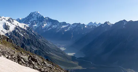
Photo: Michal Klajban, CC BY-SA 4.0, via Wikimedia Commons
Discover New Zealand
New Zealand is a country made of islands.
It is far out in the Pacific Ocean. It has two big islands and many small ones. Its Māori name is Aotearoa. The capital city is Wellington.
New Zealand is an island country in the South Pacific Ocean, more than 1,600 kilometers southeast of Australia, its nearest neighbor. It has two main islands, the North Island and the South Island, and many smaller ones. Its Māori name is Aotearoa.
The country is about 1,600 kilometers long from north to south. Snowy mountains run along the South Island, and the North Island has active volcanoes. The capital, Wellington, and the biggest city, Auckland, are both on the North Island, where most people live.
New Zealand lies in the southwestern Pacific, the southwesternmost part of Polynesia and one of the last sizable lands on Earth to be settled by people. Britannica describes it as about 1,600 km long from north to south and about 450 km across at its widest point, with an extremely long coastline for its area because of its many harbors and fiords. It has two main islands, the North and South Islands, separated by Cook Strait, plus many smaller islands, some hundreds of kilometers from the main group.
The land area is about 268,000 square kilometers, and about two-thirds of it is economically useful; the rest is mountainous. New Zealand also administers Tokelau, while Niue and the Cook Islands are self-governing states in free association with it. Stats NZ estimated the population at 5,357,300 on 30 June 2026, with about three-fourths of people living on the North Island.
Cities and famous places
Auckland is the biggest city in New Zealand.
It sits between two harbors. A tall, thin tower rises over the city. Wellington is the capital city. It has a big national museum called Te Papa.
Auckland is New Zealand's biggest city and its largest port. It sits on a narrow strip of land between two harbors, and the Sky Tower, 328 meters tall, rises above it. Auckland was founded in 1840 as the capital, but in 1865 the government moved to Wellington.
Wellington, at the southern tip of the North Island, is the capital. It is built around a harbor, and much of the city stands on land reclaimed from the bay. Te Papa Tongarewa, the national museum, moved into its present building there in 1998. On the South Island lie Christchurch and Queenstown, a town on the shore of Lake Whakatipu.
Auckland, the most populous city and largest port, occupies a narrow isthmus between Waitematā Harbour on the Hauraki Gulf/Tīkapa Moana and Manukau Harbour. Governor William Hobson founded it in 1840 as the colonial capital; Britannica notes that it has the country's greatest concentration of Māori and large numbers of Polynesians from other Pacific islands, and that it produced about two-fifths of New Zealand's GDP in the early 2020s. The 328-meter Sky Tower opened there in 1997.
Wellington replaced Auckland as the seat of government in 1865. It lies in a fault zone on the shores and hills around Wellington Harbour, and much of the city is built on reclaimed land; its institutions include the Parliament buildings and Te Papa Tongarewa, the national museum, which moved into its present building in 1998 and describes itself as bicultural. Christchurch, in the middle of the South Island, was badly damaged by earthquakes in 2010 and 2011.

Mountains, glaciers and volcanoes
The South Island has tall, snowy mountains.
The tallest one is Aoraki, also called Mount Cook. Rivers of ice, called glaciers, slide down the mountains. The North Island has volcanoes and a big lake.
New Zealand sits on the Ring of Fire, where two of Earth's giant plates meet. Their pushing makes many earthquakes and lifted up the Southern Alps, a chain of mountains about 480 kilometers long. The highest peak, Aoraki/Mount Cook, is 3,724 meters tall, and more than 360 glaciers lie in these mountains.
In the southwest, glaciers carved deep valleys that the sea later flooded, making fiords such as Milford Sound. The North Island has active volcanoes, such as Mount Ruapehu, and Lake Taupō, the country's largest natural lake, which fills an old volcanic crater.
New Zealand is part of the circum-Pacific Ring of Fire. The North Island and the western South Island lie on the Indian-Australian Plate and the rest of the South Island on the Pacific Plate; the Alpine Fault marks their contact, which UNESCO calls one of only three segments of the world's major plate boundaries on land. Collision builds the Southern Alps/Kā Tiritiri o te Moana, which rise to nearly 4,000 m within 30 km of the sea. A 2013 GPS survey led by the University of Otago found that Aoraki/Mount Cook is 3,724 m high, 30 m lower than its old official height, and Land Information New Zealand said it would adopt the new figure.
Glaciation shaped Fiordland's 15 fiords; Milford Sound is a flooded glacial valley about 19 km long and up to 512 m deep. The North Island's Volcanic Plateau holds Mount Ruapehu and Lake Taupō, a caldera created by cataclysmic eruptions some 1,800 years ago. Mean annual rainfall ranges from about 300 mm in Central Otago to as much as 6,400 mm in the Southern Alps.

Animals of New Zealand
Many birds in New Zealand cannot fly.
The kiwi has fluffy, hair-like feathers and no tail. The kākāpō is a big green parrot that walks. A reptile called the tuatara lives on a few islands.
New Zealand was cut off from other lands for a very long time, so many of its plants and animals live nowhere else. When the first people arrived, they found few animals besides birds: lizards, tuatara, a few frogs and two kinds of bats. With no predators to hunt them, birds thrived, and many are flightless.
The kiwi cannot fly and has loose, hair-like feathers, strong legs and no tail; it is a national icon. The kākāpō is a large, green, flightless parrot that is active at night, and only 325 are alive today. The tuatara, the country's largest reptile, now lives in the wild only on 32 islands. In the wild southwest live the kea, an alpine parrot, and the takahē, a rare flightless bird.
Long isolation gave New Zealand a distinctive biota: Britannica reports that almost nine-tenths of its indigenous plants are found nowhere else. When people arrived there were few animals besides birds: skinks, geckos, tuatara, a few frogs and two species of bats. Several species of moa, large flightless birds, are now extinct. Britannica also notes that introduced red deer and Australian possums have greatly damaged high-country bush, and that controlling goats, deer, possums and rabbits, even in national parks, is a continuing problem.
The Department of Conservation lists five kiwi species and describes the kākāpō as a nocturnal, flightless parrot, the heaviest parrot species (males up to 4 kg), with 325 birds alive, all on predator-free islands and in a fenced sanctuary. The tuatara (Sphenodon punctatus) is the only surviving member of the order Sphenodontia, which flourished about 200 million years ago; rats are considered the most serious threat to it. UNESCO's Te Wāhipounamu site in the southwest is home to the kea, which it calls the only alpine parrot in the world, and to the endangered takahē.

People, languages and food
About 5 million people live in New Zealand.
Most people speak English. Many people also speak Māori, called te reo Māori. Sign language is an official language too. Groups sing and dance together in kapa haka.
About 5.36 million people lived in New Zealand in 2026. Most have European roots, and the Māori, the Indigenous people of New Zealand, are a significant minority. Many families also came from Pacific islands such as Samoa, and from Asia.
New Zealand has three official languages: English, Māori (te reo Māori) and New Zealand Sign Language. Te reo Māori became official in 1987. Māori Language Week grew from Māori Language Day: 14 September 1972, when a petition asking for te reo to be taught in schools reached parliament. Kapa haka groups perform Māori songs and dances, and a hāngī is a Māori feast of meat, seafood and vegetables steamed for hours in an earth oven.
Britannica describes a majority of European origin, a significant Māori minority (about one-sixth of the population in the early 21st century) and smaller numbers of people from the Pacific islands and Asia, with Asians the fastest-growing group. English, Māori and New Zealand Sign Language are official; Samoan, Hindi and Mandarin Chinese are also widely spoken. Te Taura Whiri i te Reo Māori, the Māori Language Commission, says that for most of the 20th century the government discouraged and even banned speaking te reo. A 1972 petition with more than 30,000 signatures led to Māori Language Day, later Māori Language Week; the WAI11 claim to the Waitangi Tribunal led to the Māori Language Act 1987, which made te reo official, and the Commission works toward a goal of 1 million speakers by 2040.
Since the 1950s a Māori cultural renaissance has revived wood carving, weaving and carved meeting houses (whare whakairo); the biennial Te Matatini festival, first held in 1972, ends in a national kapa haka championship. Waitangi Day, 6 February, is the national day. At the 2023 Census, Stats NZ found for the first time that over half of people (51.6 percent) had no religion; 32.3 percent were Christian, the largest religious grouping.

A young country with a long story
Long ago, the first people came from islands far away.
They are the Māori. Much later, people came from Europe. In 1840, Māori chiefs and Britain made an agreement. It is called the Treaty of Waitangi.
New Zealand was one of the last large lands on Earth where people settled. The first settlers were Polynesians from eastern Polynesia, who arrived in the 1200s; their descendants are the Māori. The Dutch explorer Abel Tasman arrived in 1642, and the British captain James Cook visited in 1769.
In February 1840 Māori chiefs and the British Crown agreed the Treaty of Waitangi, and Britain took control of New Zealand, which became a separate colony in 1841. Many settlers from Britain followed. In 1893 New Zealand women won the right to vote, and in 1947 the country became fully independent. In 1987 te reo Māori became an official language.
Polynesian settlers from eastern Polynesia, possibly from present-day French Polynesia, arrived in the 13th century; their descendants are the Māori. Abel Tasman reached New Zealand in 1642, and by James Cook's visit in 1769 the Māori population was probably not much more than 100,000. Europeans settled from the 1820s, and diseases and musket-era warfare reduced Māori numbers. Under the Treaty of Waitangi (February 1840) Māori chiefs ceded kāwanatanga, translated as sovereignty though its meaning is much debated, in return for protection and guaranteed possession of their lands.
From 1860 about a decade of war over land spread from Taranaki to the Waikato; Britannica records land confiscations and the loss of most of the best Māori land over the following 40 years. Māori men gained the vote and four seats in 1867, and women won the vote in 1893. New Zealand became a dominion in 1907 and fully independent in 1947. Since 1975 the Waitangi Tribunal has examined claims of breaches of the Treaty, and from the early 1990s governments have agreed land, money and resource settlements and apologized for past injustices.

New Zealand on the map
Find New Zealand on the globe.
It is in the Pacific Ocean, southeast of Australia. It has a long North Island and a long South Island. The sea is all around it.
New Zealand is in the southwestern Pacific Ocean, more than 1,600 kilometers southeast of Australia. Because it is made only of islands, it shares no land border with any other country.
The North Island and the South Island are separated by Cook Strait. Together they stretch about 1,600 kilometers from north to south but only about 450 kilometers across at the widest point.
New Zealand lies in the southwestern Pacific, the southwesternmost part of Polynesia, more than 1,600 km southeast of Australia. It has no land boundary with any other country. The North and South Islands, separated by Cook Strait, run about 1,600 km north to south and about 450 km across at the widest.
Milford Sound, on the southwest coast, is an inlet of the Tasman Sea. Beyond the main islands, New Zealand administers Tokelau and claims a section of Antarctica, while Niue and the Cook Islands are self-governing states in free association with it. The Alpine Fault, a plate boundary on land, divides the southwest of the South Island.
- Length, north to south
- about 1,600 km
- Widest point
- about 450 km
- Distance to Australia
- more than 1,600 km
- Highest point
- Aoraki/Mount Cook, 3,724 m (2013 survey)
Amazing facts
-
New Zealand's tallest mountain got a little shorter.
A 2013 survey found that Aoraki/Mount Cook is 3,724 meters tall, 30 meters lower than the height people used before.
GPS measurements from a University of Otago expedition in November 2013 put Aoraki/Mount Cook at 3,724 m, 30 m below its listed 3,754 m; Land Information New Zealand said it would use the new height.
-
The kākāpō is a heavy parrot that cannot fly.
The kākāpō is the heaviest parrot in the world. Males can weigh up to 4 kilograms, and only 325 kākāpō are alive.
The Department of Conservation describes the kākāpō as the heaviest parrot species (males up to 4 kg) and the world's only lek-breeding parrot; 325 were alive, all wild, on predator-free islands and in a fenced sanctuary.
-
The tuatara's family is very, very old.
The tuatara is the last member of a group of reptiles that lived in the age of the dinosaurs. It can live up to 100 years.
Sphenodon punctatus is the only surviving member of the order Sphenodontia, well represented about 200 million years ago; tuatara grow until about age 35 and live on average about 60 years.
-
Women in New Zealand could vote in 1893.
In 1893 New Zealand women won the right to vote after a campaign of more than 20 years.
Britannica calls the winning of the franchise by women in 1893, after a campaign of more than two decades, perhaps the most significant political change of the Liberal era.
-
People celebrate the Māori language during Māori Language Week.
Māori Language Week began as Māori Language Day, the day in 1972 when a petition with more than 30,000 signatures was taken to parliament.
The Māori Language Petition, presented to parliament on 14 September 1972 with more than 30,000 signatures, gave rise to Māori Language Day, later Māori Language Week; in 2020 more than 1 million people took part in a nationwide moment of te reo.
Words to know
- fiord
- a long, narrow, deep inlet of the sea between steep cliffs, carved by a glacier
- glacier
- a huge, slow-moving river of ice
- tectonic plate
- one of the giant, slowly moving pieces of Earth's outer shell
- flightless
- describes a bird that cannot fly
- te reo Māori
- the Māori language, one of New Zealand's official languages
- treaty
- a written agreement between groups or nations
- Indigenous
- describes the first peoples known to have lived in a place
Discovery challenge
-
What is the capital city of New Zealand?
Which city is the capital of New Zealand?
Which city replaced Auckland as New Zealand's seat of government in 1865?
- Wellington
- Auckland
- Christchurch
Show the answer
Wellington
Wellington is the capital of New Zealand.
Wellington, at the southern tip of the North Island, is the capital. Auckland is the biggest city.
Auckland was founded as the colonial capital in 1840, but the seat of government moved to Wellington in 1865.
-
What is the tallest mountain in New Zealand?
Which mountain is the highest in New Zealand?
Which peak did a 2013 GPS survey measure at 3,724 meters?
- Aoraki/Mount Cook
- Mount Ruapehu
- Mitre Peak
Show the answer
Aoraki/Mount Cook
Aoraki, also called Mount Cook, is the tallest.
Aoraki/Mount Cook, in the Southern Alps, is 3,724 meters tall.
A University of Otago expedition found Aoraki/Mount Cook 30 m lower than its old official 3,754 m; Ruapehu is a North Island volcano and Mitre Peak rises above Milford Sound.
-
Which bird cannot fly and has no tail?
Which New Zealand bird cannot fly and has loose, hair-like feathers and no tail?
Which flightless bird, with hair-like feathers and no tail, is New Zealand's national icon?
- Kiwi
- Kea
- Tūī
Show the answer
Kiwi
The kiwi cannot fly. It has fluffy feathers and no tail.
The kiwi has loose, hair-like feathers, strong legs and no tail.
The Department of Conservation describes the kiwi as flightless, with loose, hair-like feathers, strong legs and no tail; it lists five kiwi species. The kea is an alpine parrot.
-
Which languages are official in New Zealand?
What are New Zealand's three official languages?
Which three languages have official status in New Zealand?
- English, Māori and New Zealand Sign Language
- English, French and Spanish
- English, Samoan and Hindi
Show the answer
English, Māori and New Zealand Sign Language
English, Māori and sign language are all official.
English, te reo Māori and New Zealand Sign Language are official. Samoan and Hindi are spoken by many people too.
The Māori Language Act 1987 made te reo official; English and New Zealand Sign Language are the others. Samoan, Hindi and Mandarin are widely spoken but not official.
-
Why does New Zealand have big mountains and earthquakes?
What causes New Zealand's high mountains and many earthquakes?
What raises the Southern Alps and causes New Zealand's frequent earthquakes?
- Two giant plates of rock push together under it
- It is very close to the Equator
- Strong winds pile up rocks
Show the answer
Two giant plates of rock push together under it
Big pieces of rock push together under New Zealand.
The Indian-Australian Plate and the Pacific Plate meet under New Zealand, pushing up mountains and shaking the ground.
Collision of the Indian-Australian and Pacific plates, whose contact is marked by the Alpine Fault, builds the Southern Alps and causes seismic activity in subduction zones and along faults.
Places to discover in New Zealand
Animals of New Zealand
-
 Watch
Animal
North Island brown kiwi
The North Island brown kiwi is a flightless bird that lives only in New Zealand's North Island. It has shaggy brown feathers, no tail, and a long bill with nostrils near the tip, so it can sniff out worms and grubs in the dark. The father keeps the huge egg warm for 75 to 90 days.
-
 Watch
Animal
Kākāpō
The kākāpō is a large, moss-green parrot from New Zealand with an owl-like face. It cannot fly, it is active at night, and it eats only plants. It nearly died out, but careful work by New Zealand's Department of Conservation has grown the population to 325 birds (September 2026).
-
 Watch
3D
Animal
Little penguin
The little penguin is the smallest penguin in the world, only about 33 centimeters long and about 1 kilogram. It lives along the coasts of southern Australia and New Zealand, where it is also called the fairy penguin, the blue penguin or kororā. It fishes at sea by day and comes ashore after dark to its burrow.
-
 Watch
Animal
Tuatara
The tuatara looks like a spiny lizard, but it is not one. It is the last living member of a group of reptiles that lived alongside the dinosaurs. Today wild tuatara live only on small islands off New Zealand, where they come out at night, grow very slowly and can live for around 100 years.
-
 Watch
Animal
Big-belly seahorse
The big-belly seahorse lives in the cool coastal waters of southeastern Australia and New Zealand. It is one of the largest seahorses, usually 18 to 28 centimeters long. It grips seaweed and jetties with its curly tail and sucks up tiny shrimp through its snout. As in all seahorses, the male carries the eggs in a pouch on his belly and gives birth to hundreds of babies.
-
 Watch
Animal
Bar-tailed godwit
The bar-tailed godwit is a long-billed shorebird that breeds on Arctic tundra and spends the rest of the year on mudflats far to the south. Godwits from Alaska fly non-stop across the Pacific Ocean to New Zealand and Australia, and one young bird tracked in 2022 flew at least 13,560 kilometers without landing.
-
 Watch
Animal
Rainbow trout
The rainbow trout gets its name from the pink-red band along each side. It comes from the cool rivers and lakes of western North America and far eastern Russia. Some rainbows stay in fresh water all their lives, while others, called steelhead, swim out to the ocean and come back to spawn.
-
 Watch
Animal
Giant oarfish
The giant oarfish is the longest bony fish in the world: it is usually about 3 meters long, and some have been reliably measured at 8 meters. Its silver, ribbon-shaped body has a red fin running all the way along its back. It lives in the open ocean, often hundreds of meters down, and drifts upright, head up, while it feeds on tiny krill.
-
 Watch
Animal
Giant squid
The giant squid is one of the biggest animals without a backbone. Most of its length is two very long, stretchy feeding tentacles. It lives deep in oceans around the world, and it is so hard to find that the first photos of a living one in the wild were taken only in 2004.
-
 Watch
Animal
Black swan
The black swan is the only swan in the world that is almost entirely black. It has a bright red bill with a white band near the tip, and white flight feathers that flash when it flies. It is native to Australia and New Zealand, and people have taken it to other countries too.
-
 Watch
Animal
Kea
The kea is a big, olive-green parrot found only on the South Island of New Zealand. It lives in mountain forests and alpine meadows, digs for food with its long, curved beak, nests on the ground and is famous for being curious, playful and clever.
-
 Watch
Animal
Colossal squid
The colossal squid lives deep in the icy Southern Ocean around Antarctica. It is thought to be the heaviest animal without a backbone: one caught in 2007 weighed about 470 kilograms. Its arms and tentacles carry sharp, turning hooks, and in 2025 scientists filmed a living one in the wild for the first time.
Explore next
-
Watch
Natural wonder
Aoraki / Mount Cook
Aoraki / Mount Cook is New Zealand's highest mountain, in the Southern Alps of the South Island. Its name joins its Māori name, Aoraki, with its English name, Mount Cook. The mountain is being pushed up where two of Earth's plates meet, and glaciers carve the valleys around it. In 2013 surveyors measured it at 3,724 meters.
-
Watch
Animal
North Island brown kiwi
The North Island brown kiwi is a flightless bird that lives only in New Zealand's North Island. It has shaggy brown feathers, no tail, and a long bill with nostrils near the tip, so it can sniff out worms and grubs in the dark. The father keeps the huge egg warm for 75 to 90 days.
-
Watch
Animal
Kākāpō
The kākāpō is a large, moss-green parrot from New Zealand with an owl-like face. It cannot fly, it is active at night, and it eats only plants. It nearly died out, but careful work by New Zealand's Department of Conservation has grown the population to 325 birds (September 2026).
- Watch Life around the world Te reo Māori in language nests, New Zealand A kōhanga reo, or "language nest," is an early-childhood center in New Zealand where young children are surrounded by te reo Māori, the Māori language, and Māori customs. Families started the first one in 1982 to help the language grow strong again.
-
Watch
3D
Animal
Little penguin
The little penguin is the smallest penguin in the world, only about 33 centimeters long and about 1 kilogram. It lives along the coasts of southern Australia and New Zealand, where it is also called the fairy penguin, the blue penguin or kororā. It fishes at sea by day and comes ashore after dark to its burrow.
-
Watch
Animal
Tuatara
The tuatara looks like a spiny lizard, but it is not one. It is the last living member of a group of reptiles that lived alongside the dinosaurs. Today wild tuatara live only on small islands off New Zealand, where they come out at night, grow very slowly and can live for around 100 years.
-
Watch
Animal
Big-belly seahorse
The big-belly seahorse lives in the cool coastal waters of southeastern Australia and New Zealand. It is one of the largest seahorses, usually 18 to 28 centimeters long. It grips seaweed and jetties with its curly tail and sucks up tiny shrimp through its snout. As in all seahorses, the male carries the eggs in a pouch on his belly and gives birth to hundreds of babies.
-
Watch
Animal
Bar-tailed godwit
The bar-tailed godwit is a long-billed shorebird that breeds on Arctic tundra and spends the rest of the year on mudflats far to the south. Godwits from Alaska fly non-stop across the Pacific Ocean to New Zealand and Australia, and one young bird tracked in 2022 flew at least 13,560 kilometers without landing.
For parents & teachers
What children will learn
- Locate New Zealand and name its two main islands and its capital.
- Explain how two meeting tectonic plates shape New Zealand's mountains, earthquakes and volcanoes.
- Describe how isolation produced flightless birds and other unique wildlife.
- Outline New Zealand's history from Polynesian settlement and the Treaty of Waitangi to today, and name its three official languages.
Recommended ages: 3 to 17 · About 15 minutes
Talk about it
- Why might birds on an island with no ground predators stop flying?
- Why do you think people work to keep languages such as te reo Māori alive?
- New Zealand's tallest mountain was measured again and found to be shorter. How do you think people measure a mountain?
Try at home or in class
- On a globe or world map, measure from Australia to New Zealand, then compare New Zealand's length with a journey you know.
- Find Wellington, Auckland and Aoraki/Mount Cook on a map and work out which island each one is on.
Key vocabulary: fiord, glacier, tectonic plate, flightless, te reo Māori, treaty, Indigenous
Where these facts come from
- Wikidata , Wikimedia Foundation (CC0 1.0)
- Natural Earth vector data , Natural Earth (NACIS) (Public domain)
- UNESCO World Heritage List , UNESCO World Heritage Centre (Linked as a reference; site facts come from Wikidata)
- National population estimates: At 30 June 2026 , Stats NZ
- 2023 Census population, dwelling, and housing highlights , Stats NZ
- Queenstown , Destination Queenstown
- New Zealand (introduction and land) , Encyclopaedia Britannica
- New Zealand: Relief , Encyclopaedia Britannica
- New Zealand: Soils (climate, plant and animal life) , Encyclopaedia Britannica
- New Zealand: People , Encyclopaedia Britannica
- New Zealand: Cultural life , Encyclopaedia Britannica
- New Zealand: Early European settlement , Encyclopaedia Britannica
- New Zealand: Responsible government , Encyclopaedia Britannica
- New Zealand: The Liberal era, 1891-1912 , Encyclopaedia Britannica
- New Zealand: The late 20th and early 21st centuries , Encyclopaedia Britannica
- Auckland , Encyclopaedia Britannica
- Wellington , Encyclopaedia Britannica
- Milford Sound , Encyclopaedia Britannica
- Lake Taupo , Encyclopaedia Britannica
- Otago-led study revises height of Aoraki/Mt Cook , University of Otago
- Our story , Te Taura Whiri i te Reo Māori (Māori Language Commission)
- Legislation , Te Taura Whiri i te Reo Māori (Māori Language Commission)
- Kiwi , Department of Conservation
- Kākāpō , Department of Conservation
- Tuatara , Department of Conservation
- Tongariro National Park , UNESCO World Heritage Centre
- Te Wahipounamu - South West New Zealand , UNESCO World Heritage Centre
- About Te Papa , Museum of New Zealand Te Papa Tongarewa
- PlayOwl region table, version 1 , PlayOwl (PlayOwl original data)
- flag-icons 7.5.0 , Panayiotis Lipiridis and contributors (MIT)
- Wikimedia Commons , Wikimedia Foundation (Per file (public domain, CC0, CC BY or CC BY-SA); see each media record)
Checked, not yet human-reviewed. Last updated October 24, 2026. Spotted a mistake? Tell us.
Picture credits
- Photo: Michal Klajban, CC BY-SA 4.0, via Wikimedia Commons · source · license
- Photo: Cupy Chan, CC BY 3.0, via Wikimedia Commons · source · license
- Photo: W. Bulach, CC BY-SA 4.0, via Wikimedia Commons · source · license
- Photo: Ulrich.hoecker, CC BY 3.0, via Wikimedia Commons · source · license
- Photo: Phillip Capper, CC BY 2.0, via Wikimedia Commons · source · license
- Photo: P. Stalder, CC BY-SA 3.0, via Wikimedia Commons · source · license
- Photo: Marek Slusarczyk, CC BY 3.0, via Wikimedia Commons · source · license
- Photo: W. Bulach, CC BY-SA 4.0, via Wikimedia Commons · source · license
- Photo: Krzysztof Golik, CC BY-SA 4.0, via Wikimedia Commons · source · license