Natural wonder Australia and Oceania
Aoraki / Mount Cook
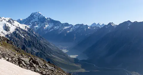
Aoraki / Mount Cook is the tallest mountain in New Zealand. It is covered in snow and ice. Glaciers flow down the valleys around it.
Aoraki / Mount Cook is New Zealand's highest mountain, in the Southern Alps of the South Island. Its name joins its Māori name, Aoraki, with its English name, Mount Cook. The mountain is being pushed up where two of Earth's plates meet, and glaciers carve the valleys around it. In 2013 surveyors measured it at 3,724 meters.
Aoraki / Mount Cook (3,724 m, from a 2013 survey) is the highest peak of the Southern Alps / Kā Tiritiri o te Moana, raised by collision along the Alpine Fault between the Indo-Australian and Pacific plates. It lies in Aoraki/Mount Cook National Park, where glaciers cover 40% of the land, within the Te Wāhipounamu - South West New Zealand World Heritage Area. A 1991 rock avalanche and later erosion lowered its summit.
Photo: Michal Klajban, CC BY-SA 4.0, via Wikimedia Commons
Discover Aoraki / Mount Cook
Aoraki / Mount Cook is a mountain in New Zealand.
It is the tallest mountain in the whole country. Its pointy top is white with snow and ice. It has two names: Aoraki and Mount Cook.
Aoraki / Mount Cook rises in the middle of New Zealand's South Island, in the Southern Alps. Its name uses both its Māori name, Aoraki, and the English name Mount Cook, which a British captain, J. L. Stokes, gave it in 1851 after the explorer James Cook.
The mountain stands in Aoraki/Mount Cook National Park. The Department of Conservation describes the park as a rugged land of ice and rock: glaciers cover 40 percent of it, and it has 19 peaks over 3,000 meters, with Aoraki / Mount Cook the highest of all.
The Department of Conservation (DOC) describes Aoraki/Mount Cook National Park, in the central South Island, as a harsh land of ice and rock: glaciers cover 40% of it and 19 peaks exceed 3,000 m, Aoraki / Mount Cook the highest. The park is part of the Te Wāhipounamu - South West New Zealand World Heritage Area, inscribed in 1990, which covers 2.6 million ha, about 10% of New Zealand's land.
The dual name pairs the Māori name Aoraki with Mount Cook, given in 1851 by Captain J. L. Stokes in honor of James Cook. DOC records that the mountain has great cultural importance to Ngāi Tahu and that it has Tōpuni status, a public symbol of Ngāi Tahu's relationship with the land; Ngāi Tahu consider it inappropriate to climb onto the summit itself.
- Country
- New Zealand (South Island)
- Height (2013 survey)
- 3,724 m
- Mountain range
- Southern Alps / Kā Tiritiri o te Moana
- Glacier cover in the national park
- 40%
- First ascent
- 1894
Pushed up by colliding plates
Deep under New Zealand, two giant pieces of Earth's crust push into each other.
The push lifts the mountains higher and higher. Ice and rain wear them down. That is how the sharp peaks were made.
New Zealand sits on the boundary between two of Earth's plates, the Indo-Australian Plate and the Pacific Plate. UNESCO explains that they meet along a great crack called the Alpine Fault, one of only three places where a major plate boundary runs across land.
As the two plates collide, they push up the Southern Alps, which rise to nearly 4,000 meters only about 30 kilometers from the sea. At the same time, glaciers and rivers wear the mountains down. During the Ice Ages, giant glaciers carved deep U-shaped valleys, and glaciers are still carving today.
UNESCO describes the Alpine Fault as the contact zone between the Indo-Australian and Pacific plates, one of only three segments of the world's major plate boundaries on land. Collision along it builds the Southern Alps / Kā Tiritiri o te Moana, which rise to nearly 4,000 m within about 30 km of the Tasman Sea. Pleistocene glaciers carved U-shaped valleys, hanging valleys, cirques and fiords across the region, and moraines and outwash gravels record former piedmont and valley glaciers.
The summit itself is changing. The University of Otago's AORAKI2013 project recounts the history of its measured height: 3,764 m from 1881 surveys, the official figure until a massive rock avalanche fell from the east face on 14 December 1991; a new official height of 3,754 m from photogrammetry afterwards; and, as the summit ridge kept eroding, a 2013 survey by photogrammetry and GNSS that found 3,724 m, 30 m below the 1991 figure and 40 m below the height before the avalanche.
Rivers of ice
Big rivers of ice called glaciers fill the valleys.
The biggest one is the Tasman Glacier. It is very long and very thick. Rocks cover its lower end.
Five big glacier valleys shape the park: the Godley, Murchison, Tasman, Hooker and Mueller. The Tasman Glacier is New Zealand's largest and longest glacier, the Department of Conservation says. It is 23 kilometers long and up to 3 kilometers wide.
Near its upper part, the ice is about 600 meters thick. Lower down, the glacier is covered in rocks and gravel, so it can look more like a stony valley than ice. You can see it from the main highway into the park.
DOC names the Godley, Murchison, Tasman, Hooker and Mueller as the five major glacial valley systems that shaped the park. The Tasman Glacier, New Zealand's largest and longest, is 23 km long, up to 3 km wide and covers 101 km²; though debris-covered in its lower reaches, its ice is about 600 m deep near the Hochstetter Icefall.
The Otago surveyors' AORAKI2013 work grew out of a study measuring the volume of ice lost by the Tasman Glacier between 1986 and 2008, which built a 3D model of the area from aerial photographs. UNESCO highlights the wider region's glaciers, including the Franz Josef and Fox glaciers, which descend into temperate rainforest.
Alpine plants and a clever parrot
Almost no trees grow in this park. Instead, there are lots of alpine flowers.
The Mount Cook lily is a giant buttercup. Kea, green mountain parrots, live here too. They are famous for their mischief!
There is almost no forest in the park, but more than 300 kinds of plants grow there, the Department of Conservation says. The most spectacular include mountain buttercups and daisies. The Mount Cook lily is actually the largest buttercup in the world.
About 40 kinds of birds live in the park. The kea, a mountain parrot, is famous for its mischievous behavior. The tiny rock wren is the only true alpine bird, surviving winter among high rocks. In the braided riverbed of the Tasman lives the kakī, or black stilt, one of New Zealand's rarest birds.
DOC records virtually no forest but more than 300 plant species, including many mountain buttercups (Ranunculus) and daisies (tikumu, Celmisia); the Mount Cook lily, Ranunculus lyallii, is the world's largest buttercup. About 40 bird species occur: the kea, a mountain parrot; the rock wren (pīwauwau), the only true alpine bird, which survives winter in high rock basins; the New Zealand falcon (kārearea) and black-backed gull (karoro) in the high country; and in the braided Tasman riverbed, the kakī or black stilt, one of New Zealand's rarest birds.
Invertebrates are rich, including large dragonflies, grasshoppers, moths and butterflies and a black alpine wētā known as the Mount Cook flea, found above the snowline; the jewelled gecko lives in the region but is rarely seen. UNESCO describes the World Heritage Area's biota as the best modern representation of the ancient life of Gondwana, with marked alpine plant endemism.

Climbers, surveyors and a mountain hotel
Climbers tried for many years to reach the top.
In 1894, three New Zealanders finally did it. Today, scientists still climb up to measure how tall the mountain is.
The first attempt to climb the mountain came in 1882, when an Irish climber, W. S. Green, and two Swiss guides got within 20 meters of the top. The summit was first reached in 1894 by three New Zealanders: Tom Fyfe, Jack Clarke and George Graham. Today the park is known as one of the finest mountaineering areas in the world.
In 2013 surveyors climbed high on the mountain carrying satellite receivers to measure its height. As agreed with Ngāi Tahu, they did not step onto the very summit, but measured from the top of the ice cap close by.
DOC's history of the park records the first attempt in 1882 by the Rev. W. S. Green with two Swiss guides, who came within 20 m of the top, and the first ascent in 1894 by Tom Fyfe, Jack Clarke and George Graham. The park is now regarded as one of the finest mountaineering areas in the world, with high-level huts equipped with radios.
DOC also records the Hermitage hotel's local hydroelectric scheme of 1925, built by hand on steep terrain, until the national grid arrived in 1961. On 23 November 2013, two teams of two climbers carrying GNSS receivers measured from the top of the ice cap, about 45 m north of the true summit and 5 m below it; as agreed with Ngāi Tahu and the three Papatipu Rūnanga with shared interests in Aoraki, they did not step on the summit.
Visiting safely
Families can walk in the valleys and look up at the mountain.
The climb to the top is only for expert mountaineers. Stay on the track and take all your trash home.
Most visitors enjoy the park from its valley walks, such as the Hooker Valley Track, which can be very busy in summer. The climb to the summit is serious mountaineering, over glaciers and steep rock and ice.
The Department of Conservation warns that avalanches can happen in the park in any season, and that most of the park is complex avalanche terrain. Check the New Zealand Avalanche Advisory and the weather before setting out. Rubbish bins are limited, so take your trash with you, and flying recreational drones is not allowed anywhere in the park.
DOC warns that avalanches can occur in any season and that most of the park is complex avalanche terrain, with very little simple terrain. It recommends checking the New Zealand Avalanche Advisory, which gives daily assessments by elevation and aspect, together with the park's weather forecast; the Avalanche Terrain Exposure Scale rates the terrain itself. Winter access (June-September) may be limited by snow on the road.
Visitor pressure is managed too: parking at White Horse Hill can be limited from November to March, and the Hooker Valley Track can be crowded. Recreational drones are banned, and visitors must carry out their rubbish, since waste in alpine areas may never break down and is unacceptable to Ngāi Tahu; where there is no toilet, a pack-it-out method is required.
Amazing facts
-
The world's biggest buttercup grows here.
The Mount Cook lily, which grows in the park, is really a buttercup, and it is the largest buttercup in the world.
DOC identifies the Mount Cook lily, Ranunculus lyallii, as the world's largest buttercup.
-
The mountain is 40 meters shorter than it used to be.
Because of a rock avalanche in 1991 and erosion afterward, Aoraki / Mount Cook is now 40 meters lower than before the avalanche.
The AORAKI2013 survey found 3,724 m, 30 m below the 3,754 m official height and 40 m below the long-standing 3,764 m.
-
A tiny insect called the Mount Cook flea lives above the snow line.
A black alpine wētā, an insect nicknamed the Mount Cook flea, lives above the snowline in the park.
DOC records a black alpine wētā, known as the Mount Cook flea, above the snowline.
-
The night sky here is full of stars.
With no cities nearby and a village with downward-facing lights, the park is one of the best places in New Zealand to see the night sky.
DOC notes that the absence of nearby towns and the village's downcast lighting make the park a prime place for stargazing.
Words to know
- glacier
- a huge mass of ice that moves slowly downhill
- fault
- a long crack in the Earth's crust where rocks move
- rock avalanche
- a huge, fast fall of rock down a mountain
- summit
- the very top of a mountain
- surveyor
- a person who measures land, heights and distances very exactly
- alpine
- high in the mountains, above where trees grow
Discovery challenge
-
Aoraki / Mount Cook is the tallest mountain in which country?
Aoraki / Mount Cook is the highest mountain in which country?
Aoraki / Mount Cook is the highest peak of which country's Southern Alps?
- New Zealand
- Australia
- Japan
Show the answer
New Zealand
New Zealand!
New Zealand, on the South Island.
New Zealand: the Southern Alps / Kā Tiritiri o te Moana.
-
Why does the mountain have two names?
Where do the two parts of the name Aoraki / Mount Cook come from?
What does the dual name Aoraki / Mount Cook combine?
- A Māori name and an English name
- Two explorers' first names
- Two nearby towns
Show the answer
A Māori name and an English name
Aoraki is its Māori name, and Mount Cook is its English name.
Aoraki is the Māori name; Mount Cook was given in 1851 after James Cook.
The Māori name Aoraki and the English name given by Captain Stokes in 1851.
-
What is pushing the mountains up?
What is lifting the Southern Alps?
Which structure marks the plate collision that builds the Southern Alps?
- Two plates of Earth's crust pushing together
- A volcano erupting
- Ocean waves
Show the answer
Two plates of Earth's crust pushing together
Two giant pieces of Earth push together.
The Pacific and Indo-Australian plates colliding along the Alpine Fault.
The Alpine Fault, between the Indo-Australian and Pacific plates.
-
Why is the mountain shorter now?
Why is Aoraki / Mount Cook lower today than in the 1980s?
What lowered the summit from 3,764 m to 3,724 m?
- A big rockfall and wearing away
- People dug off the top
- It sank into the sea
Show the answer
A big rockfall and wearing away
A huge rockfall in 1991, and the top kept wearing away.
A rock avalanche in 1991, then erosion of the summit ridge.
The 1991 rock avalanche and continued erosion of the summit ridge.
-
What is the kea?
What kind of animal is the kea that lives in the park?
Which bird does DOC describe as a mischievous mountain parrot?
- A mountain parrot
- A kind of goat
- A fish
Show the answer
A mountain parrot
A parrot that lives in the mountains!
A mountain parrot known for its mischief.
The kea, Nestor notabilis.
Nearby places
-
 Watch
City
Sydney
Sydney is Australia's largest city and the capital of the state of New South Wales. It surrounds Port Jackson, a harbor of countless bays, on the lands of the Gadigal people of the Eora Nation. The British set up a convict colony here in 1788. Today the Harbour Bridge, the Opera House and its beaches are world famous, and about 5.45 million people lived in Greater Sydney in 2023.
-
 Watch
Landmark
Sydney Opera House
The Sydney Opera House stands on a point of land in Sydney Harbour, Australia. Danish architect Jørn Utzon won a competition to design it in 1957, building began in 1959, and it opened on October 20, 1973. Its shell-shaped roofs are covered in more than a million tiles.
-
 Watch
Natural wonder
K'gari
K'gari, off the coast of Queensland in Australia, is the largest sand island in the world. Sand dunes rise up to about 250 meters, rainforest grows right on the sand, and about half of the world's perched dune lakes sparkle among the dunes. Once called Fraser Island, it was officially renamed K'gari, the Butchulla people's name for it, in 2023.
-
 Watch
Natural wonder
Great Barrier Reef
The Great Barrier Reef stretches about 2,300 kilometers along the coast of Queensland, Australia. It is made of about 2,500 separate reefs and more than 900 islands, built by tiny coral animals, and it is home to more than 1,500 kinds of fish.
-
 Watch
Natural wonder
Uluru
Uluru is a huge sandstone rock in the desert of central Australia, rising 348 meters above the plain, with a base 9.4 kilometers around. The Anangu are its Traditional Owners, and the national park around it is run by Anangu and Parks Australia together.
-
 Watch
Natural wonder
Kakadu National Park
Kakadu, in Australia's Northern Territory, is the country's largest national park. It stretches from a high sandstone cliff called the escarpment down to floodplains, mangroves and the sea. Aboriginal people have lived here for tens of thousands of years, and their rock paintings, some up to 20,000 years old, record their way of life.
-
 Watch
Natural wonder
Komodo National Park
Komodo National Park, in Indonesia, is a group of rugged, dry islands between Sumbawa and Flores. Its three main islands, Komodo, Rinca and Padar, were made by volcanoes. The park contains most of the places where wild Komodo dragons, the largest living lizards, still live, along with rich coral reefs visited by turtles, dolphins and whales.
-
 Watch
Natural wonder
Mount Agung
Mount Agung is a cone-shaped volcano on the eastern end of Bali, in Indonesia, and the island's highest point at about 3,000 meters. It erupted strongly in 1963 and 1964, and again with explosions, ash clouds and lava in its crater from 2017 to 2019. Scientists watch it all the time and set safety zones around it when it is restless.
Experiments to try
Explore next
-
Watch
 Country
New Zealand
New Zealand, also called Aotearoa, is an island country in the South Pacific. Its two main islands have snowy mountains, glaciers, volcanoes and deep fiords, and about 5.36 million people lived there in 2026.
- Watch Geography Glaciers A glacier is a huge mass of ice and snow that slowly flows over land. It forms where more snow falls than melts, year after year, until the snow is squeezed into ice. Pulled by its own weight, it creeps downhill, carving wide valleys and carrying rocks along.
- Watch Geography How mountains form Most mountains are built by moving tectonic plates. When continents collide, rock crumples and folds into ranges like the Himalayas. Where the crust stretches and cracks, blocks of rock tilt up along faults. Volcanoes build mountains from lava and ash. Then erosion slowly wears them all down.
- Watch Geography Tectonic plates Earth's hard outer shell is cracked into a dozen or so giant pieces called tectonic plates. They carry the continents and oceans and move a few centimeters a year. Where plates pull apart, push together or slide past each other, we find volcanoes, mountains and earthquakes.
-
Watch
Animal
Kea
The kea is a big, olive-green parrot found only on the South Island of New Zealand. It lives in mountain forests and alpine meadows, digs for food with its long, curved beak, nests on the ground and is famous for being curious, playful and clever.
-
 Watch
Natural wonder
Mont Blanc
Mont Blanc is the highest peak in the Alps, on the border of France and Italy. Its snowy top changes height a little from year to year: in September 2026, French surveyors measured it at 4,807.47 meters. People first climbed it in 1786, and today a long tunnel runs right underneath it.
- Watch Try it What If? Lab What if glaciers melted? Glaciers are huge, slow-moving masses of ice on land. When land ice melts, its water runs into the ocean and raises the sea. In our model, melting every mountain glacier on Earth would lift the sea by about 40 centimeters; scientists' best estimate is a little less, about 32.
-
Watch
Natural wonder
Great Barrier Reef
The Great Barrier Reef stretches about 2,300 kilometers along the coast of Queensland, Australia. It is made of about 2,500 separate reefs and more than 900 islands, built by tiny coral animals, and it is home to more than 1,500 kinds of fish.
For parents & teachers
What children will learn
- Locate Aoraki / Mount Cook in New Zealand's Southern Alps and explain its dual name.
- Explain how plate collision along the Alpine Fault raises the mountains.
- Explain why the mountain's measured height has changed.
- Describe the park's glaciers, plants and birds and how to visit safely.
Recommended ages: 3 to 17 · About 15 minutes
Talk about it
- Why might a mountain have names in two languages?
- How can a mountain be pushed up and worn down at the same time?
- Why do you think the surveyors chose not to stand on the very top?
Try at home or in class
- Push two towels together on a table and watch the folds rise up, like mountains at a plate boundary.
- Build a small sand 'peak', measure it, then knock a little off the top and measure again, like the 1991 rock avalanche.
Key vocabulary: glacier, fault, rock avalanche, summit, surveyor, alpine
Where these facts come from
- Wikidata , Wikimedia Foundation (CC0 1.0)
- Natural Earth vector data , Natural Earth (NACIS) (Public domain)
- Aoraki/Mount Cook National Park , New Zealand Department of Conservation
- Historic Aoraki/Mount Cook , New Zealand Department of Conservation
- Be avalanche alert in Aoraki/Mt Cook National Park , New Zealand Department of Conservation
- AORAKI2013: surveying the height of Aoraki/Mt Cook , University of Otago, School of Surveying
- Te Wahipounamu - South West New Zealand , UNESCO World Heritage Centre
- Wikimedia Commons , Wikimedia Foundation (Per file (public domain, CC0, CC BY or CC BY-SA); see each media record)
Checked, not yet human-reviewed. Last updated October 27, 2026. Spotted a mistake? Tell us.