
 Country
North America
Saint Barthélemy
Saint Barthélemy is a small, hilly island in the Caribbean Sea. It is part of France. Its main town, Gustavia, has a harbor full of boats.
Saint Barthélemy is a small island in the northeastern Caribbean Sea and an overseas collectivity of France. For almost a hundred years it belonged to Sweden, which is why its only town is called Gustavia. INSEE, France's statistics office, counted 10,660 people living there.
Saint-Barthélemy, a French overseas collectivity since February 2007 and formerly a commune of Guadeloupe, lies about 200 km north of Guadeloupe's main islands on the Anguilla Bank. Swedish from 1784 to 1877, it keeps the Swedish-era name of its only town, Gustavia. INSEE's legal population, in force from 1 January 2026, is 10,660 (reference date 1 January 2023).
Photo: Evaneggers, CC BY-SA 3.0, via Wikimedia Commons
Discover Saint Barthélemy
Saint Barthélemy is an island in the warm Caribbean Sea.
It is part of France. People there speak French.
Saint Barthélemy is a small, hilly island in the Lesser Antilles, a long chain of islands in the eastern Caribbean Sea. It lies about 200 kilometers north of the main islands of Guadeloupe. Many people call it Saint-Barth for short.
Saint Barthélemy is part of France. Since 2007 it has been an overseas collectivity, which means it makes many of its own decisions about local laws and taxes. Before that, it was part of Guadeloupe.
Britannica describes Saint-Barthélemy as an island of the Lesser Antilles, about 200 km north of Guadeloupe's main islands, mountainous yet fertile despite relatively little rain. It was a commune and, with Saint-Martin, an arrondissement of the French département of Guadeloupe until voters approved a change of status in 2003; it became an overseas collectivity in February 2007.
The collectivity remains part of France but has broad authority over its own fiscal and legislative affairs. The president of France is head of state, represented by a prefect; a 19-member Territorial Council, led by its president, makes local laws, and an eight-member Executive Council is chosen by it. Saint-Barthélemy elects a representative and a senator to the French Parliament.
Gustavia, its harbor and its forts
Gustavia is the island's only town.
Many boats float in its harbor. Red roofs cover the hills.
Gustavia is the capital and the only town. It stands on a well-sheltered harbor and was named after King Gustav III of Sweden. In the photo, sailboats and yachts fill the harbor, and houses with red roofs climb the green hills around it.
In Swedish times, four forts guarded the town. The remains of Fort Carl, built in 1789, still stand on a rocky hill southwest of Gustavia. From the top you can see the town, small islets and other islands such as Saint Martin and Saba.
Gustavia, the capital and only town, stands on a well-sheltered harbor and is named for Sweden's King Gustav III (Britannica). Four forts framed it in the Swedish era: Gustav, Carl, Anglais and Octav. Fort Carl, a light battery built in 1789 to defend the town from the south, survives as ruins on a dry-forest hill southwest of Gustavia; the Conservatoire du littoral took it over in 2007 and restored parts of it, and since 2021 Gustavia elementary pupils have helped care for the site. Its summit looks over the town, the islets and Saba, Saint Kitts and Nevis, Sint Eustatius and Saint Martin.
In 2025 the IEDOM's annual report, as summarized by Outremers360, counted 232,548 passengers at the island's airport and 219,558 arrivals at the port of Gustavia. The photo shows the harbor crowded with sailboats and motor yachts, red-roofed houses on the slopes and a white wooden bell tower in the foreground.
Old rocks, a coral lagoon and 18 islets
Long ago, the sea was much lower.
Then this island was part of a much bigger island.
Saint Barthélemy is hilly, and its highest point, Morne du Vitet, rises to 286 meters. The land is covered in dry forest or wetlands, and the coast has rocky shores and beaches.
About 18,000 years ago the sea was 100 meters lower than today. Saint Barthélemy, Saint Martin and Anguilla were then joined in one big island, almost twice the size of Guadeloupe. That helps explain why some animals live only on these islands today.
At Grand Cul-de-Sac, a reef of elkhorn coral helped create a calm, shallow lagoon where young sea creatures grow.
The island sits at the northern end of the Lesser Antilles arc on the Anguilla Bank, with Saint-Martin, Tintamarre and Anguilla. Its rocks, marine and volcanic formations with later deposits, date from about 51 to 24 million years ago. About 18,000 years ago sea level stood 100 m lower, and the bank formed a single island almost twice the size of Guadeloupe; the territorial environment agency (ATE) says this helps explain the endemic reptiles and other wildlife found only on these islands.
Morne du Vitet reaches 286 m (Wikidata; Britannica gives a maximum of 281 m). A reef of elkhorn coral (Acropora palmata) helped create the Grand Cul-de-Sac lagoon, a calm, shallow nursery for sea life; the ATE reports that it was affected by global warming in October 2024. Eighteen islets surround the island, half of them privately owned. As towns grew, seabirds moved away from the main island and now nest only on the islets, so some islets are closed to visitors all year.
Sea turtles, seabirds and a marine reserve
Three kinds of sea turtles lay eggs on the beaches.
Dogs are not allowed on the beaches, to keep turtles and birds safe.
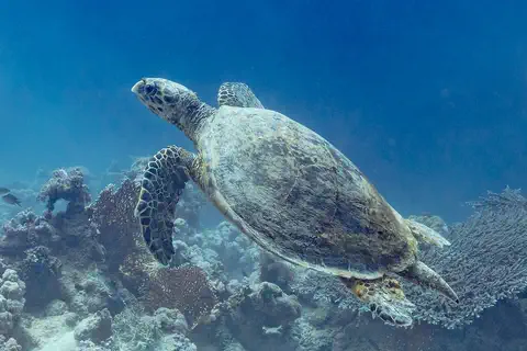
Hawksbill, green and leatherback turtles come ashore to lay their eggs on Saint Barthélemy's beaches. If you see a turtle nesting, stay at least 20 meters away, and keep 3 meters from baby turtles. Dogs have been banned from every beach since 1986, partly to protect birds and turtles. The hawksbill in the photo was swimming over a reef in Egypt.
The Saint-Barthélemy Nature Reserve, created in 1996, protects 1,200 hectares of sea around the island.
The ATE lists three sea turtles nesting on the island's beaches: hawksbill, green and leatherback. Watchers must keep at least 20 m from a laying female and 3 m from hatchlings, never touch a turtle, and keep light and noise low, with red light preferred. Dogs have been banned from all beaches since a 1986 by-law, partly because they can disturb birds and turtles or damage nests. Beach plants, which hold dunes together, also serve as turtle nesting sites. The hawksbill pictured was photographed in Ras Muhammad National Park, Egypt.
The Saint-Barthélemy Nature Reserve, created on 10 October 1996 as France's 132nd nature reserve, covers 1,200 ha of sea and is managed by the ATE. Some of the island's species are strictly endemic, and others are found only on the Anguilla Bank islands; they are protected under the island's Environmental Code.
People, language and island work
About 10,000 people live on the island.
Many visitors come by plane and by boat.
INSEE counted 10,660 people living in Saint Barthélemy (on 1 January 2023, the official figure since 2026). French is the official language. Britannica notes that the island's rocky, dry soil never supported plantations worked by enslaved people.
Tourism drives the island's economy. In 2025 it welcomed 333,052 visitors, more than ever before, reports France's overseas issuing institute, the IEDOM. Building work and hotels and restaurants employ many people, and a few farms grow flowers and other plants.
INSEE's legal population for Saint-Barthélemy is 10,660 (statistical reference 1 January 2023, in force from 1 January 2026); the IEDOM notes decades of growth driven largely by workers arriving from outside. Britannica notes that the island's rocky, arid soil never supported plantations worked by enslaved people.
The IEDOM's 2025 annual report, summarized by Outremers360, calls tourism the main engine of the economy: a record 333,052 visitors in 2025 (+6.5%), a high-end hotel sector and 17.2 million euros in tourist tax. Construction employed nearly one worker in five at the end of 2025. Farming is marginal: six farms in 2020, twice as many as ten years earlier, turning to flowers and horticulture on scarce land.
French, then Swedish, then French again
France sold the island to Sweden long ago.
Later, the people voted, and it became French again.
The French occupied Saint Barthélemy in 1648. In 1784 France sold it to Sweden, and the Swedes named the town Gustavia after their king. In 1877, after the islanders voted in a plebiscite, the island was returned to France.
For many years Saint Barthélemy was part of Guadeloupe. In 2003 voters agreed to a new status, and in 2007 it became an overseas collectivity of France.
Britannica dates the French occupation to 1648. In 1784 the island was sold to Sweden, and the Swedish era (1784–1877, as the ATE dates it) left the name Gustavia, after King Gustav III, and four forts, including Fort Carl of 1789. After a plebiscite the island was returned to France in 1877.
As a commune of Guadeloupe it shared an arrondissement with Saint-Martin. Guadeloupe began preparing its devolution in the mid-1990s; voters approved the change in 2003, and the overseas collectivity was created in February 2007. Bruno Magras was elected the first president of the Territorial Council on 16 July 2007. The marine nature reserve dates from 1996, after a local nature-protection association formed in 1988 pushed for it.
Saint Barthélemy on the map
Find the Caribbean Sea on the globe.
Look near the top of the curved chain of small islands. Saint Barthélemy is a tiny dot there.
Saint Barthélemy lies about 18 degrees north of the equator, in the northeastern Caribbean Sea. Saint Martin lies to the northwest, and Guadeloupe's main islands are about 200 kilometers to the south.
The island is too small for the globe to draw, so PlayOwl marks places with dots: Gustavia, Fort Gustav III, Fort Carl, Morne du Vitet, Grand Cul-de-Sac and the airport.
Gustavia lies at about 17.90° N, 62.85° W, on the Anguilla Bank southeast of Saint Martin, about 200 km north of Guadeloupe's main islands. Île Fourchue, an islet to the northwest, rises to 103 m (Wikidata).
At the globe's scale the island has no outline, so the map uses markers: Gustavia; the Swedish battery of Fort Gustav III; Fort Carl; Morne du Vitet, 286 m; Grand Cul-de-Sac; and the airport at Saint-Jean.
- Guadeloupe's main islands
- about 200 km south
- People (1 January 2023)
- 10,660
- Nature reserve (sea)
- 1,200 hectares
- Satellite islets
- 18
Amazing facts
-
The town of Gustavia is named after a king of Sweden.
Gustavia is named after King Gustav III of Sweden, because the island belonged to Sweden for almost a hundred years.
Gustavia takes its name from Sweden's King Gustav III; Sweden held the island from 1784 until its return to France in 1877.
-
Dogs may not go on any beach here.
Dogs have been banned from all of Saint Barthélemy's beaches since 1986, even on a leash, partly to protect nesting turtles and birds.
A 1986 municipal by-law bans dogs, even leashed, from every beach, protecting birds and nesting turtles and keeping the sand free of parasites.
-
Long ago, this island was joined to its neighbors.
18,000 years ago, when the sea was 100 meters lower, Saint Barthélemy, Saint Martin and Anguilla were one big island.
At the last low sea level, about 18,000 years ago, the Anguilla Bank formed one island almost twice the size of Guadeloupe.
-
Seabirds nest on small islands around Saint Barthélemy.
Eighteen islets surround Saint Barthélemy. Some are closed to visitors so that seabirds can raise their chicks in peace.
Of the 18 satellite islets, half are privately owned; several, such as Gros Îlets and Pain de Sucre, are off-limits all year to protect nesting seabirds.
Words to know
- overseas collectivity
- a part of France outside Europe that makes many of its own local laws and tax rules
- plebiscite
- a vote in which all the people of a place decide one big question
- lagoon
- a calm, shallow stretch of sea sheltered by a reef or a strip of land
- islet
- a very small island
- endemic
- found naturally in one place and nowhere else
Discovery challenge
-
Which country did Saint Barthélemy belong to for almost 100 years?
Which country owned Saint Barthélemy from 1784 to 1877?
To which kingdom was Saint-Barthélemy sold in 1784?
- Sweden
- Spain
- Portugal
Show the answer
Sweden
Sweden!
Sweden. The town is still called Gustavia, after a Swedish king.
Sweden, until the island was returned to France after an 1877 plebiscite.
-
What is the island's only town called?
What is the name of Saint Barthélemy's capital and only town?
Which town, named for King Gustav III, is the island's capital?
- Marigot
- Gustavia
- Philipsburg
Show the answer
Gustavia
Gustavia.
Gustavia. Marigot and Philipsburg are on the island of Saint Martin.
Gustavia, on a well-sheltered harbor.
-
Which animal may NOT go on the beaches here?
Which animals have been banned from Saint Barthélemy's beaches since 1986?
Which animals did a 1986 by-law ban from every beach, partly to protect nesting turtles?
- Crabs
- Dogs
- Seabirds
Show the answer
Dogs
Dogs. It keeps turtles and birds safe.
Dogs, even on a leash, to protect turtles and birds.
Dogs, including leashed dogs.
-
Which country is Saint Barthélemy part of today?
Saint Barthélemy is an overseas collectivity of which country?
Since 2007, Saint-Barthélemy has been an overseas collectivity of which country?
- The Netherlands
- France
- Sweden
Show the answer
France
France.
France. It returned to France in 1877 and has been an overseas collectivity since 2007.
France; before 2007 it was a commune of Guadeloupe.
Animals of Saint Barthélemy
-
Watch
3D
Animal
Hawksbill sea turtle
The hawksbill sea turtle lives in warm seas around the world, mostly near coral reefs. Its pointed, hawk-like beak reaches into cracks in the reef to find sponges, its favorite food. Its beautiful patterned shell once made it a target for hunters, and today it is critically endangered.
-
 Watch
Animal
Green sea turtle
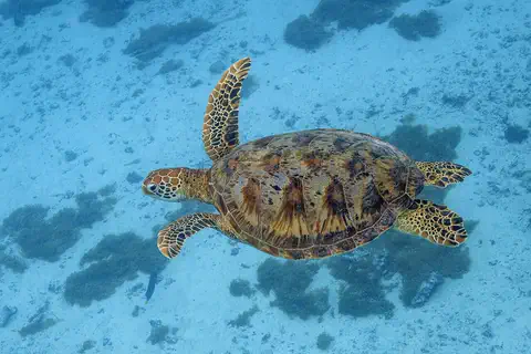
The green sea turtle is the largest sea turtle with a hard shell. It lives in warm seas around the world and, unlike other sea turtles, grown-ups eat mostly seagrass and algae. Females swim hundreds or even thousands of kilometers to lay their eggs on the beaches where they hatched long ago.
Explore next
-
 Watch
 Country
Saint Martin
Saint-Martin covers the northern two-thirds of the island of Saint Martin, in the northeastern Caribbean Sea. It is an overseas collectivity of France, and its capital is Marigot. The southern third of the same island is Sint Maarten, a country within the Kingdom of the Netherlands. INSEE, France's statistics office, counted 31,160 people in Saint-Martin.
-
 Watch
 Country
Sint Maarten
Sint Maarten covers the southern third of the island of Saint Martin, in the northeastern Caribbean Sea. It is a country within the Kingdom of the Netherlands, and its capital is Philipsburg. The northern part of the same island is Saint-Martin, which belongs to France. About 42,449 people lived in Sint Maarten at the start of 2025.
-
 Watch
 Country
Guadeloupe
Guadeloupe is a group of French islands in the Lesser Antilles. Its two main islands, mountainous Basse-Terre and low Grande-Terre, are split by a narrow channel. It is a French overseas department and region, and 384,160 people lived there on January 1, 2023.
-
 Watch
 Country
France
France is a country in northwestern Europe, between the Atlantic Ocean and the Mediterranean Sea. It has high mountains such as the Alps and the Pyrenees, long rivers such as the Loire and the Seine, and about 69.1 million people (2026). Its capital is Paris.
-
 Watch
 Country
Sweden
Sweden is a country in northern Europe on the Scandinavian Peninsula. It stretches about 1,600 kilometers from north to south, with forests, many lakes and a rocky coast full of islands. About 10.6 million people live there, and its capital is Stockholm.
-
 Watch
 Country
Anguilla
Anguilla is a low coral island in the eastern Caribbean, the most northerly of the Leeward Islands. Its long, thin shape gave it a name that comes from the French word for eel. It is a British overseas territory, famous for its white beaches, and the statistics office estimated 16,010 people at the end of 2024.
-
Watch
3D
Animal
Hawksbill sea turtle
The hawksbill sea turtle lives in warm seas around the world, mostly near coral reefs. Its pointed, hawk-like beak reaches into cracks in the reef to find sponges, its favorite food. Its beautiful patterned shell once made it a target for hunters, and today it is critically endangered.
-
Watch
Animal
Green sea turtle
The green sea turtle is the largest sea turtle with a hard shell. It lives in warm seas around the world and, unlike other sea turtles, grown-ups eat mostly seagrass and algae. Females swim hundreds or even thousands of kilometers to lay their eggs on the beaches where they hatched long ago.
For parents & teachers
What children will learn
- Locate Saint Barthélemy in the northeastern Caribbean, near Saint Martin.
- Explain how a place can change countries, as Saint Barthélemy did from France to Sweden and back.
- Describe how lower sea levels once joined nearby islands.
- Describe simple rules that protect nesting sea turtles and seabirds.
Recommended ages: 3 to 17 · About 15 minutes
Talk about it
- Gustavia still has a Swedish name, though the island is French. What other places keep names from their past?
- Why might seabirds choose small islets instead of the main island to nest?
- Saint Barthélemy has more than 30 visitors a year for every person who lives there. What might be good and hard about that?
Try at home or in class
- Fill a tray with sand and water, build two 'islands' of sand, then lower the water to see how they join into one.
- Make a beach-rules sign for turtle season with three tips: stay back, keep lights low, leave baby turtles alone.
Key vocabulary: overseas collectivity, plebiscite, lagoon, islet, endemic
Where these facts come from
- Wikidata , Wikimedia Foundation (CC0 1.0)
- Natural Earth vector data , Natural Earth (NACIS) (Public domain)
- Saint-Barthélemy , Encyclopaedia Britannica
- Populations des collectivités d'outre-mer en 2023 (recensement de la population) , INSEE
- History of the nature reserve , Agence Territoriale de l'Environnement de Saint-Barthélemy
- Geology , Agence Territoriale de l'Environnement de Saint-Barthélemy
- Natural environments , Agence Territoriale de l'Environnement de Saint-Barthélemy
- On the beach , Agence Territoriale de l'Environnement de Saint-Barthélemy
- Satellite islands , Agence Territoriale de l'Environnement de Saint-Barthélemy
- Save the native fauna , Agence Territoriale de l'Environnement de Saint-Barthélemy
- Discovery tour: Fort Carl , Agence Territoriale de l'Environnement de Saint-Barthélemy
- Saint-Barthélemy : une économie dynamisée par le tourisme, d'après le rapport annuel de l'IEDOM , Outremers360
- PlayOwl region table, version 1 , PlayOwl (PlayOwl original data)
- flag-icons 7.5.0 , Panayiotis Lipiridis and contributors (MIT)
- Wikimedia Commons , Wikimedia Foundation (Per file (public domain, CC0, CC BY or CC BY-SA); see each media record)
Checked, not yet human-reviewed. Last updated November 1, 2026. Spotted a mistake? Tell us.