
 Country
North America
Saint Martin
Saint Martin is the northern part of a small island in the Caribbean Sea. It is part of France. The southern part of the island is Dutch.
Saint-Martin covers the northern two-thirds of the island of Saint Martin, in the northeastern Caribbean Sea. It is an overseas collectivity of France, and its capital is Marigot. The southern third of the same island is Sint Maarten, a country within the Kingdom of the Netherlands. INSEE, France's statistics office, counted 31,160 people in Saint-Martin.
The French overseas collectivity of Saint-Martin, separate from Guadeloupe since February 2007, occupies the northern two-thirds of the island of Saint Martin; the southern third is Sint Maarten, a country within the Kingdom of the Netherlands. Its summit, Pic Paradis (424 m), is the island's high point. INSEE's legal population, in force from 1 January 2026, is 31,160 (reference date 1 January 2023).
Photo: Zerokarma, CC BY-SA 3.0, via Wikimedia Commons
Discover Saint Martin
Saint Martin is on an island in the warm Caribbean Sea.
The island has two parts. Saint Martin is the northern part, and it is French.
The island of Saint Martin lies near the northern end of the Lesser Antilles, a long chain of islands in the eastern Caribbean Sea. It is only about 19 kilometers from north to south. Its northern two-thirds is Saint-Martin, part of France, and its southern third is Sint Maarten, part of the Kingdom of the Netherlands.
Saint-Martin is an overseas collectivity, which means it is part of France but makes many of its own decisions about local laws and taxes. French is the official language, and English is widely spoken.
Britannica describes the island of Saint Martin as lying at the northern end of the Leeward group of the Lesser Antilles, about 19 km across in each direction, with an area of 88 km². The northern two-thirds is tied historically and administratively to France, the southern third to the Netherlands.
Until February 2007 Saint-Martin was a commune of the French département of Guadeloupe and, with Saint-Barthélemy, one of its arrondissements. As an overseas collectivity it remains part of France but has broad authority over its fiscal and legislative affairs. The president of France is head of state, represented by a prefect; a 23-member Territorial Council, led by its president, makes local laws and elects a seven-member Executive Council, both for five-year terms. Saint-Martin sends a representative and a senator to the French Parliament. French is the official language, and Britannica notes that English is widely spoken.
Marigot, Grand Case and Pic Paradis
The capital is Marigot. It has red roofs and a harbor full of boats.
Green hills rise behind the town.
Marigot is the capital. The photo looks down over the town: houses with red roofs, a waterfront with market stalls, a harbor full of boats and green hills behind. Fort Louis, a former fort dating from 1789, is in Marigot.
Grand Case, near Marigot, has an airport. Princess Juliana International Airport, in the Dutch part, serves both parts of the island. Pic Paradis, at 424 meters, is the highest point on the whole island.
Marigot, the capital, is described by Britannica as an important port and trade center; Fort Louis, a former military fort dating from 1789, stands in the town (Wikidata). An airport at Grand Case serves the French side, while Princess Juliana International Airport, west of Philipsburg in the Dutch part, serves both parts of the island.
Pic Paradis (424 m) is the island's highest point and lies in the French part (Wikidata). The photo looks down on Marigot: red-roofed houses, a waterfront promenade with colorful market stalls, a harbor with moored boats and, beyond, a wide bay and green hills.
Dry forest, salt ponds and coral reefs
Saint Martin has green hills and quiet ponds.
Coral reefs and sea grass grow in the sea nearby.
Saint-Martin has beaches and hills covered in forest. Much of its natural plant life is dry forest, with fan palms called latania and cactuses. The island gets about 1,140 millimeters of rain a year.
The Saint-Martin Nature Reserve, created in 1998, protects about 2,900 hectares of sea in the northeast, along with coastal land and ponds. It looks after five kinds of habitat: coral reefs, mangroves, seagrass meadows, ponds and dry coastal forest. Fourteen protected ponds have been on the Ramsar list of important wetlands since 2012.
Britannica describes Saint-Martin's vegetation as primarily dry forest with groves of latania (a fan palm) and cactus, on beaches and forest-covered hills; the whole island receives about 1,140 mm of rain a year. Pic Paradis rises to 424 m.
The Saint-Martin Nature Reserve, created in 1998 in the island's northeast, covers about 2,900 ha of sea on the shelf between Anguilla, Saint Martin and Saint-Barthélemy, plus 154 ha of coastal land (11 km of shoreline) and 198 ha of wetlands administered by the Conservatoire du littoral. It protects the island's five main ecosystems: coral reefs, mangroves, seagrass beds, ponds and dry coastal forest. Its 14 protected ponds, listed under the Ramsar Convention since 1 May 2012, soften floods, protect the coast and filter water before it reaches the sea, but face dumping and untreated wastewater. Reefs protect the coast from swell; boats must use moorings or anchor on sand, because anchors and chains destroy corals that take decades to recover.
Singing whales, seabirds and nesting turtles
From January to May, big whales sing in the sea near Saint Martin.
Many seabirds and sea turtles live here too.
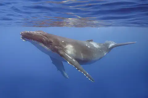
Nine kinds of sea mammals can be seen in Saint-Martin's waters. From January to May, divers may hear male humpback whales singing; one song can last up to half an hour before the whale comes up to breathe. The young humpback in the photo was swimming off French Polynesia.
Eighty-five kinds of birds live around the island, including pelicans, egrets and red-billed tropicbirds. Early figures showed that 2023 was a very good nesting season for sea turtles, especially hawksbills. On the French side, digging up or disturbing the wild Pope's head cactus is against the law.
The reserve lists nine marine mammal species; from January to May divers may hear male humpback whales, which can sing underwater for up to half an hour before surfacing, and a 2012 survey between Saint Martin, Anguilla and Saint-Barthélemy recorded four dolphin species and several sperm whales. Eighty-five bird species occur, 55 of them protected, among them the great and snowy egrets, red-billed tropicbird, bridled tern, Audubon's shearwater, least tern and pelican; brown noddies nest on Tintamarre's cliffs, and because a frightened noddy may destroy its nest, boats may no longer anchor in North Cove bay or land people there. The humpback pictured is a calf off Moorea, French Polynesia.
Volunteers and reserve staff track turtle nests each year; preliminary data showed that the 2023 season, which ended on 30 November, was particularly good, especially for hawksbills. On Tintamarre, 150 automatic traps were used to control introduced rats between July 2022 and October 2023, and the reserve is working toward bringing back the Lesser Antillean iguana. Disturbing or uprooting wild Pope's head cactus (Melocactus intortus) is prohibited on the French side, and in 2026 the reserve and the Nature Foundation Sint Maarten completed the first island-wide survey of the species.
People, languages and work
About 31,000 people live in Saint Martin.
They speak French and English.
INSEE counted 31,160 people living in Saint-Martin (on 1 January 2023, the official figure since 2026). Britannica notes that most people are of African or mixed African and European heritage. French is the official language, and English is widely spoken.
Tourism is the main business. In 2025 the whole island welcomed about 2.6 million visitors, many arriving on cruise ships, reports France's overseas issuing institute, the IEDOM. Building work and shops also employ many people.
INSEE's legal population for Saint-Martin is 31,160 (statistical reference 1 January 2023, in force from 1 January 2026); the IEDOM notes a decade of population decline. Britannica describes most residents as of African or mixed African-European heritage, with French official and English widely spoken.
The IEDOM's 2025 report, summarized by Outremers360, calls tourism the main engine of Saint-Martin's economy: 2.6 million visitors to the whole island in 2025 (+15.7%), including 1.6 million cruise passengers and 963,159 air passengers. About 95.5% of visitors arrive through the Dutch part's transport links, and the French part aims at higher-value tourism. Salaried jobs reached a record 8,119 at the end of 2025, and construction remains an important employer.
Sugarcane, freedom and a new collectivity
In 1648 the French and the Dutch agreed to divide the island.
Today the French part makes many of its own rules.
Christopher Columbus's ships sighted the island in November 1493. Several European countries claimed it, and in 1648 the French and the Dutch divided it. The French part was run from Guadeloupe.
Sugarcane grown by enslaved people became the main business. Slavery was abolished in 1848. Tourism began to grow in the 1970s. In 2003 voters agreed to a new status, and in 2007 Saint-Martin became an overseas collectivity of France.
Columbus's ships sighted the island in November 1493. Valued for its natural salt lakes, it was claimed by several European powers, notably the Dutch and the French, who partitioned it in 1648; the French portion came under the government of the colony of Guadeloupe. Sugarcane, worked by enslaved labor, became the mainstay of the economy until slavery was abolished in 1848, after which the economy languished for a time.
Tourism developed from the 1970s. Guadeloupe began preparing Saint-Martin's devolution in the mid-1990s; voters approved the change in 2003, and the overseas collectivity was created in February 2007. Louis-Constant Fleming was elected the first president of the Territorial Council on 16 July 2007.
Saint Martin on the map
Find the Caribbean Sea on the globe.
Look near the top of the curved chain of small islands. Saint Martin is the northern part of one of them.
Saint-Martin lies about 18 degrees north of the equator, in the northeastern Caribbean Sea. It shares its island with Sint Maarten, the Dutch part, to the south. Anguilla lies just to the north, and Saint-Barthélemy to the southeast.
The island is too small for the globe to draw, so PlayOwl marks places with dots: Marigot, Fort Louis, Grand Case and its airport, Pic Paradis, Orient Bay and the islet of Tintamarre.
Marigot lies at about 18.07° N, 63.08° W. Saint-Martin's only land border is with Sint Maarten, which covers the southern third of the island; Philipsburg lies about 6 km southeast of Marigot. Anguilla lies to the north and Saint-Barthélemy to the southeast, on the same shallow shelf.
At the globe's scale the island has no outline, so the map uses markers: Marigot, Fort Louis, Grand Case and L'Espérance Airport, Pic Paradis (424 m), Orient Bay and Tintamarre, an islet in the nature reserve.
- Island of Saint Martin
- 88 km², shared with Sint Maarten
- People (1 January 2023)
- 31,160
- Highest point of the island
- Pic Paradis, 424 m
- Nature reserve (sea)
- about 2,900 hectares
Amazing facts
-
Saint Martin shares its island with a Dutch country.
One island, two parts: the north is Saint-Martin, part of France, and the south is Sint Maarten, in the Kingdom of the Netherlands.
The island of Saint Martin has been divided since 1648: the northern two-thirds is the French collectivity of Saint-Martin and the southern third is Sint Maarten.
-
Whales sing in the sea near Saint Martin.
From January to May, divers near Saint-Martin may hear male humpback whales singing; one song can last up to half an hour.
Male humpback whales can vocalize underwater for up to half an hour before surfacing; divers may hear them from January to May.
-
On the French side, wild cactuses may not be dug up.
The Pope's head cactus has a red 'crown' on top. On the French side, it is against the law to dig up or disturb the wild plants.
Melocactus intortus, the Pope's head cactus, grows a tall red cephalium when mature; disturbing or uprooting wild plants is prohibited by law on the French side.
-
Ponds help keep the sea clean.
Saint-Martin's ponds soak up floodwater after heavy rain and clean the water before it flows into the sea.
The ponds reduce flooding during heavy rain, protect the coast, let sediment settle and purify water before it is released to the sea.
Words to know
- overseas collectivity
- a part of France outside Europe that makes many of its own local laws and tax rules
- mangrove
- a tree or shrub that grows in salty water along tropical coasts
- Ramsar site
- a wetland listed under an international agreement as important to protect
- partition
- dividing a place into parts, each run by a different country
- nature reserve
- an area protected by law so that its plants and animals stay safe
Discovery challenge
-
Which country is Saint Martin part of?
Saint-Martin is an overseas collectivity of which country?
Since 2007, Saint-Martin has been an overseas collectivity of which country?
- The Netherlands
- France
- The United Kingdom
Show the answer
France
France.
France. The southern part of the island, Sint Maarten, is in the Kingdom of the Netherlands.
France; before February 2007 it was a commune of Guadeloupe.
-
What is the highest hill on the island called?
What is the island of Saint Martin's highest point?
Which summit, 424 m high, in the French part, is the island's high point?
- Sentry Hill
- Pic Paradis
- Mount Scenery
Show the answer
Pic Paradis
Pic Paradis.
Pic Paradis, 424 meters. Sentry Hill is the highest point of Sint Maarten.
Pic Paradis, 424 m; Sentry Hill (340 m) is Sint Maarten's highest point.
-
Which whales sing near Saint Martin?
Which whales can divers hear singing near Saint-Martin from January to May?
Which whale's males may be heard singing in the reserve from January to May?
- Narwhals
- Humpback whales
- Beluga whales
Show the answer
Humpback whales
Humpback whales!
Humpback whales. One song can last up to half an hour.
Humpback whales, whose males can sing for up to half an hour before surfacing.
-
In which year did slavery end in Saint Martin?
In which year was slavery abolished in French Saint-Martin?
In which year was slavery abolished, after which Saint-Martin's sugarcane economy languished?
- 1648
- 1848
- 2007
Show the answer
1848
1848.
1848. In 1648 the island was divided, and in 2007 Saint-Martin became a collectivity.
1848.
Animals of Saint Martin
-
Watch
3D
Animal
Humpback whale
The humpback whale is a baleen whale famous for leaping out of the water, slapping its giant flippers and singing long, complex songs. It lives in every ocean and makes one of the longest journeys of any mammal, between cold feeding waters and warm waters where calves are born. Once hunted almost to extinction, it is now recovering.
-
 Watch
3D
Animal
Hawksbill sea turtle
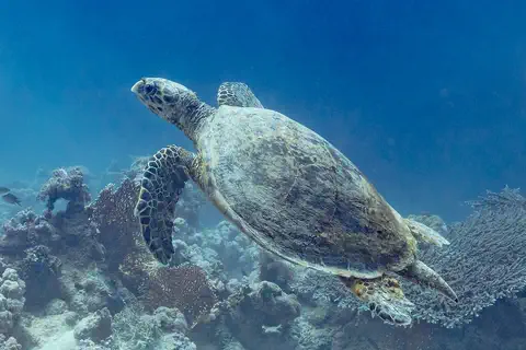
The hawksbill sea turtle lives in warm seas around the world, mostly near coral reefs. Its pointed, hawk-like beak reaches into cracks in the reef to find sponges, its favorite food. Its beautiful patterned shell once made it a target for hunters, and today it is critically endangered.
Explore next
-
 Watch
 Country
Sint Maarten
Sint Maarten covers the southern third of the island of Saint Martin, in the northeastern Caribbean Sea. It is a country within the Kingdom of the Netherlands, and its capital is Philipsburg. The northern part of the same island is Saint-Martin, which belongs to France. About 42,449 people lived in Sint Maarten at the start of 2025.
-
 Watch
 Country
Saint Barthélemy
Saint Barthélemy is a small island in the northeastern Caribbean Sea and an overseas collectivity of France. For almost a hundred years it belonged to Sweden, which is why its only town is called Gustavia. INSEE, France's statistics office, counted 10,660 people living there.
-
 Watch
 Country
Guadeloupe
Guadeloupe is a group of French islands in the Lesser Antilles. Its two main islands, mountainous Basse-Terre and low Grande-Terre, are split by a narrow channel. It is a French overseas department and region, and 384,160 people lived there on January 1, 2023.
-
 Watch
 Country
France
France is a country in northwestern Europe, between the Atlantic Ocean and the Mediterranean Sea. It has high mountains such as the Alps and the Pyrenees, long rivers such as the Loire and the Seine, and about 69.1 million people (2026). Its capital is Paris.
-
 Watch
 Country
Anguilla
Anguilla is a low coral island in the eastern Caribbean, the most northerly of the Leeward Islands. Its long, thin shape gave it a name that comes from the French word for eel. It is a British overseas territory, famous for its white beaches, and the statistics office estimated 16,010 people at the end of 2024.
-
Watch
3D
Animal
Humpback whale
The humpback whale is a baleen whale famous for leaping out of the water, slapping its giant flippers and singing long, complex songs. It lives in every ocean and makes one of the longest journeys of any mammal, between cold feeding waters and warm waters where calves are born. Once hunted almost to extinction, it is now recovering.
-
Watch
3D
Animal
Hawksbill sea turtle
The hawksbill sea turtle lives in warm seas around the world, mostly near coral reefs. Its pointed, hawk-like beak reaches into cracks in the reef to find sponges, its favorite food. Its beautiful patterned shell once made it a target for hunters, and today it is critically endangered.
- Watch Geography Islands An island is a piece of land surrounded by water that is smaller than a continent. Islands form in different ways: some broke away from continents, some were built by volcanoes on the sea floor, and some were made by corals or by waves piling up sand. Because they are cut off by water, islands often have unusual plants and animals.
For parents & teachers
What children will learn
- Locate Saint-Martin on the island of Saint Martin in the northeastern Caribbean.
- Explain how one island can be shared by two countries.
- Describe how ponds, mangroves and reefs protect coasts and wildlife.
- Outline how Saint-Martin became an overseas collectivity of France.
Recommended ages: 3 to 17 · About 15 minutes
Talk about it
- The two parts of the island have worked together to study the Pope's head cactus. Why might nature need neighbors to cooperate?
- Why do you think boats are asked to anchor on sand instead of on coral?
- How might a pond protect a town from flooding?
Try at home or in class
- Make a 'wetland sponge': pour water slowly onto a dry sponge and onto a plate, and compare how much water runs off.
- Draw the island of Saint Martin with its two parts, and mark Marigot, Philipsburg and Pic Paradis.
Key vocabulary: overseas collectivity, mangrove, Ramsar site, partition, nature reserve
Where these facts come from
- Wikidata , Wikimedia Foundation (CC0 1.0)
- Natural Earth vector data , Natural Earth (NACIS) (Public domain)
- Saint-Martin (overseas collectivity, France) , Encyclopaedia Britannica
- Saint Martin (island, West Indies) , Encyclopaedia Britannica
- Populations des collectivités d'outre-mer en 2023 (recensement de la population) , INSEE
- Réserve naturelle de Saint-Martin (home) , Association de gestion de la Réserve naturelle de Saint-Martin
- Introduction , Association de gestion de la Réserve naturelle de Saint-Martin
- Écosystèmes et espèces emblématiques , Association de gestion de la Réserve naturelle de Saint-Martin
- Les tortues marines suivies à la trace , Association de gestion de la Réserve naturelle de Saint-Martin
- First island-wide assessment of Saint Martin's iconic Pope's head cactus completed , Nature Foundation Sint Maarten
- Saint-Martin : un tourisme en progression mais d'importants défis structurels à relever, selon le rapport annuel de l'IEDOM , Outremers360
- PlayOwl region table, version 1 , PlayOwl (PlayOwl original data)
- flag-icons 7.5.0 , Panayiotis Lipiridis and contributors (MIT)
- Wikimedia Commons , Wikimedia Foundation (Per file (public domain, CC0, CC BY or CC BY-SA); see each media record)
Checked, not yet human-reviewed. Last updated November 1, 2026. Spotted a mistake? Tell us.