
 Country
North America
Anguilla
Anguilla is a long, flat island in the Caribbean Sea. White sand beaches run along its shores. Its name means eel, because it is long and thin.
Anguilla is a low coral island in the eastern Caribbean, the most northerly of the Leeward Islands. Its long, thin shape gave it a name that comes from the French word for eel. It is a British overseas territory, famous for its white beaches, and the statistics office estimated 16,010 people at the end of 2024.
Anguilla, 26 km long and at most 6 km wide, is a flat coral and limestone island 19 km north of Saint Martin and the northernmost of the Leeward Islands. A British overseas territory since it separated from Saint Kitts and Nevis, it counts tourism and financial services as its main economic activities, Britannica says. Its statistics department estimated 16,010 people in December 2024, up from 13,572 at the 2011 census.
Photo: Josveek Huligar, CC BY-SA 3.0, via Wikimedia Commons
Discover Anguilla
Anguilla is an island in the Caribbean Sea.
It is long, thin and flat. The main town is called The Valley.
Anguilla lies in the eastern Caribbean Sea, about 19 kilometers north of the island of Saint Martin. It is the most northerly of the Leeward Islands, part of the long curve of the Lesser Antilles.
The island is about 26 kilometers long but only 6 kilometers across at its widest. Its name comes from anguille, the French word for eel, because of its long, thin shape. Anguilla is a British overseas territory with its own premier and House of Assembly. English is the official language, people use the Eastern Caribbean dollar, and the main town is The Valley.
Britannica places Anguilla about 19 km north of Saint Martin and 100 km northwest of Saint Kitts, the most northerly of the Leeward Islands in the Lesser Antilles. Its 91 km² include several small uninhabited islands, the largest being Dog, Scrub and Sombrero islands and the Prickly Pear Cays.
Anguilla is a British overseas territory. Britannica describes a governor appointed by the British monarch who is in charge of external affairs, defense and internal security, and notes that the United Kingdom is responsible for defense. The territory's elected government is led by a premier, and laws are made by the House of Assembly. English is official, and the currency is the Eastern Caribbean dollar, issued by the Eastern Caribbean Central Bank.
The Valley, Wallblake House and the cays
The Valley is the main town. An old pink house with green shutters stands there.
Small islands lie around Anguilla. No one lives on them.
The Valley, near the middle of the island, is the main town and the center of government. The photo shows Wallblake House, a pink wooden house with green shutters built in the 1700s, with stone outbuildings and a white picket fence. Wallblake Airport is nearby.
Around Anguilla lie small islands where no one lives, such as Scrub Island off the eastern tip, Dog Island and the Prickly Pear Cays. Far to the northwest is Sombrero. Britannica notes frequent ferries to Marigot, on Saint Martin.
The Valley is the principal town and administrative center; the 2011 census counted 1,298 people in The Valley itself (including Upper and South Valley). Wallblake House, shown here, is an 18th-century plantation house (Wikidata), photographed in 2012; Britannica says Wallblake Airport, near The Valley, links Anguilla with international airports on other islands.
The territory includes uninhabited offshore islands, the largest being Dog, Scrub and Sombrero islands and the Prickly Pear Cays. Britannica notes frequent ferry service between Anguilla and Marigot, Saint Martin.
A flat coral island
Anguilla is low and flat. It is made of old coral rock.
There are no rivers. Salty ponds lie near the coast. It is warm all year.
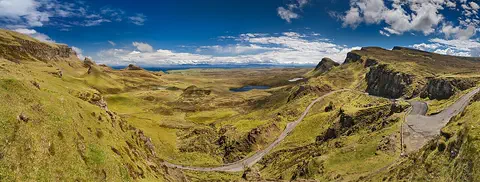
Anguilla was formed from coral and limestone. The land is gently rolling, and the highest point, Crocus Hill, is only 64 meters high. The north coast has steep cliffs, while the south coast slopes gently down to the sea.
There are no rivers, and fresh water is scarce. Salty ponds near the coast were once used to make salt. The weather is warm, about 28 °C on average, and about 900 millimeters of rain falls in a year. Hurricanes can strike from June to November, and storms in 1995 and 1999 washed away parts of some beaches.
Britannica describes an island of coral and limestone, fairly flat but undulating, rising to Crocus Hill at 64 m (Wikidata gives 65 m). Short slopes and steep cliffs mark the north coast; the south slopes gently to the sea. The soil is thin, with small pockets of red loam in shallow valleys called bottoms.
Fresh water is scarce and there are no rivers, but several saltwater ponds near the coasts supplied a salt industry until it collapsed in the 1980s. The climate is tropical, averaging about 28 °C with about 900 mm of rain a year. Hurricanes, notably those of 1995 and 1999, and indiscriminate sand mining have eroded beaches; vegetation is mainly small trees and low scrub inland and sea grape along the coasts.
Turtledoves, sea turtles and lobsters
Anguilla's national bird is a dove.
Sea turtles swim in the sea. Goats wander almost everywhere on the island.
Many kinds of birds live on Anguilla, and its national bird is the turtledove. The island is also a popular resting stop for birds that migrate.
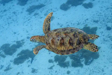
Sea turtles and lobsters live in the seas around the island. Reptiles live on land, and goats are found almost everywhere. The turtle photo here was taken in French Polynesia.
Britannica lists land reptiles, sea turtles, lobsters and ubiquitous goats among Anguilla's wildlife, and many bird species, including the national bird, the turtledove; the island is a popular stop for migratory birds.
Britannica calls fishing Anguilla's traditional livelihood. The green sea turtle shown here was photographed off Moorea, French Polynesia; Britannica does not name the kinds of sea turtle found around Anguilla.
Fishing, beaches and visitors
People on Anguilla speak English.
Many visitors come to enjoy the white beaches. Fishing is an old way of earning a living here.
Most Anguillans have African ancestors, and English is the official language. The population has grown: the 2011 census counted 13,572 people, and the statistics office estimated 16,010 at the end of 2024.
Tourism matters a great deal. In June 2026 alone, 26,838 visitors arrived, more than the number of people who live on the island. Fishing is the island's traditional way of earning a living.
Britannica describes a population mostly of African descent, mainly Christian, with English as the official language. The 2011 census counted 13,572 people, and Anguilla's Statistics Department estimated 16,010 in December 2024.
Tourism and financial services are the main economic activities, Britannica says. The Statistics Department recorded 26,838 visitor arrivals in June 2026, more than one and a half times the resident population.
Malliouhana to a British overseas territory
Long ago, people from South America came to Anguilla in canoes.
Later, British settlers arrived. Today Anguilla is a British overseas territory.
About 4,000 years ago, people whose ancestors came from the Orinoco River area of South America settled the island. They called it Malliouhana.
British settlers from Saint Kitts arrived in 1650. Later, Anguilla was governed together with Saint Kitts, which Anguilla's landowners protested. Britain ended slavery in its colonies in 1834. In 1967 Anguillans set up their own government rather than stay joined to Saint Kitts and Nevis, and Britain later took direct charge. In 1980 Anguilla formally became a separate British territory.
Britannica dates settlement by Arawakan-speaking peoples from the Orinoco basin to about 2000 BCE; they called the island Malliouhana. British settlers from Saint Kitts colonized it in 1650, and it was administered within the Leeward Islands colony. A legislative union with Saint Kitts (1825) was opposed by Anguillan landowners, and an 1882 act joined Saint Kitts, Nevis and Anguilla. Slavery ended in 1834.
Droughts in the 1890s and the Depression sent many Anguillans to work in the Dominican Republic, Aruba and Curaçao. Universal adult suffrage came in 1952. In 1967 Anguilla was made part of an associated state with Saint Kitts and Nevis against its wishes, and set up its own government. Britain restored its rule in 1969, the Anguilla Act of 1971 placed the island directly under British control, a 1976 constitution brought internal autonomy, and in 1980 Anguilla formally became a separate dependent territory, called an overseas territory from 2002.
Anguilla on the map
Find the Caribbean Sea on the globe.
Look at its eastern side, where a curve of small islands begins. The island at the top of the curve is Anguilla.
Anguilla is at the northern end of the Leeward Islands, the curve of small islands on the eastern edge of the Caribbean Sea. It lies about 18 degrees north of the equator, with Saint Martin about 19 kilometers to the south and Saint Kitts about 100 kilometers to the southeast.
Anguilla has no land borders. It is too small for the globe to draw, so PlayOwl marks it with dots: The Valley, Crocus Hill, Scrub Island and faraway Sombrero.
Anguilla lies at about 18.2° N, 63.05° W, 19 km north of Saint Martin and 100 km northwest of Saint Kitts, at the northern end of the Leeward Islands. Its long axis runs roughly southwest to northeast. It has no land borders.
At the globe's scale the island has no outline of its own, so the map uses markers: The Valley, Wallblake House, Crocus Hill, Scrub Island off the eastern tip, and Sombrero to the northwest.
- Island size
- 26 × 6 km
- Highest point
- Crocus Hill, 64 m
- People (estimate, Dec 2024)
- 16,010
- Saint Martin
- about 19 km south
Amazing facts
-
Anguilla's name means eel.
Anguilla is named after anguille, the French word for eel, because the island is long and thin.
Anguilla's long, thin shape, 26 km by at most 6 km, gave it a name from the French anguille, 'eel'.
-
Anguilla has no rivers at all.
Anguilla has no rivers, but salty ponds near the coast were once used to make salt.
Anguilla has no rivers; its coastal saltwater ponds supplied a salt industry until it collapsed in the 1980s.
-
In one summer month, more visitors came than people live on Anguilla.
In June 2026, 26,838 visitors arrived on Anguilla, more than the whole population of about 16,000.
The Statistics Department recorded 26,838 visitor arrivals in June 2026 against an estimated resident population of 16,010.
-
The first people called the island Malliouhana.
Anguilla's first people, who came from South America about 4,000 years ago, called it Malliouhana.
Arawakan-speaking settlers from the Orinoco basin, arriving about 2000 BCE, called the island Malliouhana.
Words to know
- overseas territory
- a place far from a country's main land that belongs to that country and governs itself in many ways
- limestone
- rock made long ago from shells and coral
- cay
- a small, low island of sand or coral
- salt pond
- a shallow pond of seawater that dries in the sun and leaves salt behind
- migratory bird
- a bird that flies long distances between places at different times of year
- estimate
- a careful best guess of a number, made when it has not just been counted
Discovery challenge
-
Anguilla is named after which animal?
Anguilla's name comes from the French word for which long, thin animal?
Which animal's French name, anguille, gave Anguilla its name?
- An eel
- A turtle
- A goat
Show the answer
An eel
An eel! The island is long and thin.
An eel, because of the island's long, thin shape.
The eel; the island is 26 km long and at most 6 km wide.
-
Which bird is Anguilla's national bird?
What is Anguilla's national bird?
Which bird does Britannica name as Anguilla's national bird?
- The flamingo
- The turtledove
- The penguin
Show the answer
The turtledove
The turtledove.
The turtledove.
The turtledove; the island is also a stop for migratory birds.
-
How many rivers does Anguilla have?
How many rivers flow on Anguilla?
How many rivers does the coral-limestone island of Anguilla have?
- Ten
- Two
- None
Show the answer
None
None at all.
None. Fresh water is scarce on the island.
None; there are only coastal saltwater ponds.
-
Which island is just south of Anguilla?
Which island lies about 19 kilometers south of Anguilla?
Anguilla lies 19 km north of which island, reached by ferry to Marigot?
- Saint Martin
- Jamaica
- Iceland
Show the answer
Saint Martin
Saint Martin.
Saint Martin, about 19 kilometers away.
Saint Martin; ferries link Anguilla with Marigot.
Places to discover in Anguilla
Animals of Anguilla
Explore next
-
 Watch
 Country
Saint Martin
Saint-Martin covers the northern two-thirds of the island of Saint Martin, in the northeastern Caribbean Sea. It is an overseas collectivity of France, and its capital is Marigot. The southern third of the same island is Sint Maarten, a country within the Kingdom of the Netherlands. INSEE, France's statistics office, counted 31,160 people in Saint-Martin.
-
 Watch
 Country
Saint Kitts and Nevis
Saint Kitts and Nevis is a country of two volcanic islands in the Lesser Antilles, in the eastern Caribbean. Saint Kitts has a volcano with a crater lake and an old fortress, Brimstone Hill; round Nevis is almost all one mountain. The country became independent from Britain in 1983. Its 2022 census counted 51,320 people.
-
 Watch
 Country
United Kingdom
The United Kingdom, or UK, lies on islands off the northwest coast of Europe. It is made up of four parts, England, Scotland, Wales and Northern Ireland, and about 69.5 million people live there. Its capital is London.
-
 Watch
Natural wonder
Caribbean Sea
The US National Hurricane Center counts the Caribbean Sea as part of the Atlantic basin. Along the coast of Belize lies the largest barrier reef in the northern hemisphere, UNESCO says. Far below, in the Cayman Trough, the sea floor is slowly spreading apart, and scientists have found hot springs there almost 5,000 meters down.
-
Watch
Animal
Green sea turtle
The green sea turtle is the largest sea turtle with a hard shell. It lives in warm seas around the world and, unlike other sea turtles, grown-ups eat mostly seagrass and algae. Females swim hundreds or even thousands of kilometers to lay their eggs on the beaches where they hatched long ago.
- Watch Geography Islands An island is a piece of land surrounded by water that is smaller than a continent. Islands form in different ways: some broke away from continents, some were built by volcanoes on the sea floor, and some were made by corals or by waves piling up sand. Because they are cut off by water, islands often have unusual plants and animals.
-
 Watch
 Country
Sint Maarten
Sint Maarten covers the southern third of the island of Saint Martin, in the northeastern Caribbean Sea. It is a country within the Kingdom of the Netherlands, and its capital is Philipsburg. The northern part of the same island is Saint-Martin, which belongs to France. About 42,449 people lived in Sint Maarten at the start of 2025.
-
 Watch
 Country
British Virgin Islands
The British Virgin Islands are a British overseas territory in the eastern Caribbean Sea: 4 larger islands and 32 smaller ones. Most are hilly, but Anegada is flat coral. Sailing is the favorite sport, and the main town is Road Town on Tortola. The census in 2010 counted 28,054 people.
For parents & teachers
What children will learn
- Locate Anguilla at the northern end of the Leeward Islands.
- Describe a flat coral-limestone island and why fresh water is scarce there.
- Explain how Anguilla came to be a separate British overseas territory.
- Compare the island's population with its number of visitors.
Recommended ages: 3 to 17 · About 15 minutes
Talk about it
- Anguilla has no rivers. Where might people on a dry island get their water?
- Storms and sand mining have washed away some beaches. How could people protect a beach?
- In one month more visitors arrived than people live on the island. What might be good, and what might be hard, about that?
Try at home or in class
- Make salt like Anguilla's old salt ponds: pour salty water into a shallow dish, leave it in a sunny window and look for crystals after a few days.
- Draw an eel and an outline of Anguilla side by side. Do you see why the island got its name?
Key vocabulary: overseas territory, limestone, cay, salt pond, migratory bird, estimate
Where these facts come from
- Wikidata , Wikimedia Foundation (CC0 1.0)
- Natural Earth vector data , Natural Earth (NACIS) (Public domain)
- Anguilla (land, climate, people, economy, government and society) , Encyclopaedia Britannica
- Anguilla: history , Encyclopaedia Britannica
- Anguilla Statistics Department: key figures (estimated population, visitor arrivals) , Anguilla Statistics Department
- Census , Anguilla Statistics Department
- Anguilla: islands, territory and districts, census 1974 to 2011 (from Anguilla's Statistics Department) , City Population (Thomas Brinkhoff)
- Government of Anguilla , Government of Anguilla
- PlayOwl region table, version 1 , PlayOwl (PlayOwl original data)
- flag-icons 7.5.0 , Panayiotis Lipiridis and contributors (MIT)
- Wikimedia Commons , Wikimedia Foundation (Per file (public domain, CC0, CC BY or CC BY-SA); see each media record)
Checked, not yet human-reviewed. Last updated November 1, 2026. Spotted a mistake? Tell us.