
 Country
North America
Sint Maarten
Sint Maarten is the southern part of a small island in the Caribbean Sea. The northern part is French. Sea turtles lay eggs on its beaches.
Sint Maarten covers the southern third of the island of Saint Martin, in the northeastern Caribbean Sea. It is a country within the Kingdom of the Netherlands, and its capital is Philipsburg. The northern part of the same island is Saint-Martin, which belongs to France. About 42,449 people lived in Sint Maarten at the start of 2025.
Sint Maarten, a country within the Kingdom of the Netherlands since the Netherlands Antilles were dissolved on 10 October 2010, occupies the southern third of the island of Saint Martin; the northern two-thirds form the French collectivity of Saint-Martin. Its Department of Statistics estimated 42,449 residents on 1 January 2025, a series anchored to the 2022 census count of 41,902.
Photo: Dr. Thomas Liptak, CC BY-SA 4.0, via Wikimedia Commons
Discover Sint Maarten
Sint Maarten is on an island in the warm Caribbean Sea.
The island has two parts. Sint Maarten is the southern part.
Sint Maarten is the southern part of the island of Saint Martin, near the northern end of a chain of islands called the Lesser Antilles. The whole island is only about 19 kilometers from north to south. Its northern two-thirds is Saint-Martin, part of France, and its southern third is Sint Maarten.
Sint Maarten is a country within the Kingdom of the Netherlands. It runs its own everyday affairs, while the Netherlands handles defense and relations with other countries. Its official languages are Dutch and English.
Britannica places the island of Saint Martin at the northern end of the Leeward group of the Lesser Antilles, about 19 km from north to south and about as wide, with an area of 88 km². The southern third is tied historically and administratively to the Netherlands, the northern two-thirds to France.
Since 10 October 2010, Sint Maarten has been a country within the Kingdom of the Netherlands. The Dutch monarch is represented by a governor; a prime minister presides over the Council of Ministers, and a unicameral Parliament of 15 members is elected by proportional representation for four years. Sint Maarten is independent in internal affairs, while the Netherlands is responsible for defense and foreign relations. Dutch and English are both official languages.
Philipsburg, a salt pond and an old fort
The capital is Philipsburg. It sits by a sandy bay.
Palm trees grow along the beach.
Philipsburg is the capital and the main town. The photo shows Great Bay Beach in Philipsburg: palm trees, white sand, small boats on clear green water and a steep green hill behind the town.
Just north of the town lies the Great Salt Pond, a salt lake. Near Philipsburg stands Fort Amsterdam, a Dutch fort from the 1600s. Princess Juliana International Airport, west of Philipsburg, serves both parts of the island.
Philipsburg is the capital and main settlement (Britannica). The Great Salt Pond, a salt lake, lies just north of the town, and Fort Amsterdam, a 17th-century Dutch fort, stands nearby (Wikidata). Salt mattered here: Britannica notes that the island was valued for its natural lakes of salt, a scarce commodity in Europe, and changed between Dutch and Spanish hands several times.
Princess Juliana International Airport, west of Philipsburg in the Dutch part, serves both the Dutch and the French parts of the island; the French side also has an airport at Grand Case, near Marigot. The photo of Great Bay Beach shows palms along the sand, moored boats and green hills rising behind the town.
Hills, lagoons and a marine park
Sint Maarten has green hills and salty ponds.
Under the sea there are coral reefs full of fish.
Sint Maarten's middle is mostly hilly. The hills slope down to lagoons, salt pans and long strips of sand. The highest point is Sentry Hill, at 340 meters. The weather is warm and sunny all year, with rain spread fairly evenly through the year.
In 2010 Sint Maarten created the Man of War Shoal Marine Park, south of Philipsburg. It covers 31 square kilometers of sea with coral reefs, seagrass meadows, shipwrecks, sea turtles, dolphins and sharks. Fishing is not allowed anywhere in the park.
Britannica describes a mostly hilly interior sloping to coastal lagoons, salt pans and sand spits, with a warm, sunny climate and moderate rainfall spread fairly evenly; the island as a whole receives about 1,140 mm a year. Sentry Hill, at 340 m, is Sint Maarten's highest point (Wikidata); the island's summit, Paradis Peak (424 m), is in the French part (Wikidata: Pic Paradis).
The Man of War Shoal Marine Park, established on 31 December 2010, was Sint Maarten's first legally protected area. It covers 31 km² south of Philipsburg, with stony and fan corals, seagrass, sand and rocky bottoms, nine official dive sites and wrecks including the Proselyte, a warship that sank in 1801. All fishing is banned inside the park. The Nature Foundation, which manages it, reports Caribbean reef, tiger and nurse sharks there. On land, the government announced plans in October 2026 to make about 17 hectares of returned hillside land Sint Maarten's first land park; no timeline or legal designation had been set.
Sea turtles, sharks and a rare lizard
Sea turtles crawl onto the beaches at night.
They dig holes in the sand and lay their eggs.
From about May to December, three kinds of sea turtle come ashore to nest: green, hawksbill and leatherback turtles. A female crawls up the beach at night or early in the morning, digs a hole with her flippers and can lay more than 100 eggs. The babies hatch on their own about 40 to 80 days later. People help by keeping beaches dark and giving turtles space. The leatherback in the photo was photographed on a beach whose place is not recorded.
The hills are home to the bearded anole, a lizard the Nature Foundation says is found nowhere else in the world.
The Nature Foundation reports that green, hawksbill and leatherback turtles nest from roughly May to December, with Simpson Bay, Dawn Beach and Gibbs Bay among the busiest sites. Females come ashore at night or in the early morning, dig a nest with their flippers, can lay upwards of 100 eggs, and leave them to hatch in about 40 to 80 days. Sea turtles are protected under the Nature Ordinance; bright white light and beach furniture can disturb or block them. The leatherback pictured has no recorded location.
The Man of War Shoal Marine Park shelters Caribbean reef, tiger and nurse sharks, dolphins, spiny lobsters, seahorses and conch. On land, the hillsides hold the bearded anole, which the Nature Foundation describes as found nowhere else in the world. In 2026 the Nature Foundation and the managers of the French side's nature reserve completed the first island-wide survey of the Pope's head cactus, assessing nearly 4,000 plants on both sides of the island.

People, languages and visitors
People here speak English and Dutch.
Many visitors come to enjoy the beaches.
Sint Maarten's Department of Statistics estimated 42,449 people on 1 January 2025, a little more than a year earlier. About half of the growth came from more babies being born than people dying, and about half from more people moving in than moving out.
Britannica notes that most of the island's people descend from Africans who were enslaved and forced to work on sugarcane plantations. It describes an economy based more and more on tourism, built on the island's clean beaches and pleasant climate. Since March 2025 Sint Maarten has shared a new currency, the Caribbean guilder, with Curaçao.
The Department of Statistics (STAT) estimated 42,449 residents on 1 January 2025, about 0.4% more than a year earlier; roughly 52% of the growth came from natural increase and 48% from net migration. Its series is benchmarked to the 2022 Population and Housing Census count of 41,902, and the 2025 figure may be revised as late registrations arrive.
Britannica writes that most of the island's inhabitants descend from enslaved Africans who worked the sugarcane plantations, which declined in the 19th century. It describes an economy based increasingly on tourism, as the government promotes the island's beaches and climate, and the Nature Foundation says the marine park draws thousands of visitors. In March 2025 the Caribbean guilder, a new currency shared with Curaçao, went into circulation, replacing the Netherlands Antillean guilder; the Central Bank of Curaçao and Sint Maarten led the change (IMF).
Salt, a shared island and a new country
Long ago, Arawak and Carib peoples lived on the island.
In 1648 the Dutch and the French agreed to divide it.
Arawak and Carib peoples lived on the island before Christopher Columbus's ships sighted it on 11 November 1493. Its lakes of salt made it valuable, and it changed hands between the Dutch and the Spanish several times.
In 1648 the Dutch and the French signed a treaty to divide the island between them. The Dutch part joined the Dutch West Indies in 1828 and the Netherlands Antilles in 1954. When the Netherlands Antilles were dissolved in 2010, Sint Maarten became a country within the Kingdom of the Netherlands.
The Arawak and Carib inhabited the island before Columbus's sighting on 11 November 1493, the feast day of St. Martin of Tours, for whom it was named. Valued for its salt lakes, it passed between Dutch and Spanish hands several times; in 1648 the Dutch returned to find the French there, and the two signed a partition treaty, known as the Treaty of Concordia (Wikidata). Sugarcane plantations worked by enslaved Africans were important for a time but declined in the 19th century.
The Dutch part joined the Dutch West Indies in 1828, came under collective administration with five other Dutch islands in 1845 and became part of the Netherlands Antilles in 1954. In 1989 Sint Maarten's leaders announced a wish for independence, but the island chose greater autonomy within the kingdom instead; in 2006 it agreed to dissolve the Netherlands Antilles, which happened on 10 October 2010.
Sint Maarten on the map
Find the Caribbean Sea on the globe.
Look near the top of the curved chain of small islands. Sint Maarten is the southern part of one of them.
Sint Maarten lies about 18 degrees north of the equator, in the northeastern Caribbean Sea. It shares its island with Saint-Martin, the French part, to the north. The island of Anguilla lies to the north and Saint-Barthélemy to the southeast.
The island is too small for the globe to draw, so PlayOwl marks places with dots: Philipsburg, the Great Salt Pond, Fort Amsterdam, Sentry Hill, the airport and Dawn Beach.
Philipsburg lies at about 18.02° N, 63.04° W. Sint Maarten's only land border is with the French collectivity of Saint-Martin, which covers the northern two-thirds of the island; Marigot, its capital, lies about 6 km northwest of Philipsburg. Anguilla lies to the north and Saint-Barthélemy to the southeast.
At the globe's scale the island has no outline, so the map uses markers: Philipsburg, the Great Salt Pond, Fort Amsterdam, Sentry Hill, Princess Juliana International Airport and Dawn Beach, a turtle-nesting beach.
- Island of Saint Martin
- 88 km², shared with France's Saint-Martin
- People (1 January 2025, estimate)
- 42,449
- Sint Maarten's area
- 34 km²
- Man of War Shoal Marine Park
- 31 km² of sea
Amazing facts
-
Sint Maarten shares its island with a part of France.
One island, two parts: the south is Sint Maarten, in the Kingdom of the Netherlands, and the north is Saint-Martin, part of France.
The island of Saint Martin has been divided since 1648: the southern third is Sint Maarten and the northern two-thirds is the French collectivity of Saint-Martin.
-
One airport helps people visit both parts of the island.
Princess Juliana International Airport, in the Dutch part, serves both the Dutch and the French parts of the island.
Princess Juliana International Airport, west of Philipsburg, serves both parts of the island; the French side also has an airport at Grand Case.
-
An old ship lies under the sea in the marine park.
Proselyte Reef, the marine park's most famous dive site, is where a warship sank in 1801.
The Man of War Shoal Marine Park's best-known dive site, Proselyte Reef, marks a warship that sank there in 1801.
-
A sea turtle can lay more than 100 eggs at once.
A nesting sea turtle on Sint Maarten can lay more than 100 eggs, which hatch on their own after about 40 to 80 days.
Nesting females can lay upwards of 100 eggs per nest; incubation on Sint Maarten's beaches takes roughly 40 to 80 days.
Words to know
- constituent country
- a country that is one of the parts of a larger kingdom; Sint Maarten is one of the countries in the Kingdom of the Netherlands
- salt pan
- a flat, shallow area where seawater dries up and leaves salt behind
- marine park
- an area of sea protected by law to keep its animals and plants safe
- partition
- dividing a place into parts, each run by a different country
- nesting season
- the months of the year when sea turtles come ashore to lay eggs
Discovery challenge
-
Which kingdom is Sint Maarten part of?
Sint Maarten is a country within which kingdom?
Since 2010, Sint Maarten has been a constituent country of which kingdom?
- The Kingdom of the Netherlands
- The United Kingdom
- The Kingdom of Spain
Show the answer
The Kingdom of the Netherlands
The Kingdom of the Netherlands.
The Kingdom of the Netherlands, since 10 October 2010.
The Kingdom of the Netherlands, after the Netherlands Antilles were dissolved on 10 October 2010.
-
In which year did the Dutch and French agree to share the island?
In which year did the Dutch and the French sign a treaty dividing the island?
In which year was the island of Saint Martin partitioned by treaty between the Dutch and the French?
- 1493
- 1648
- 2010
Show the answer
1648
1648!
1648. In 1493 Columbus's ships sighted the island, and in 2010 Sint Maarten became a country.
1648, the treaty known as the Treaty of Concordia.
-
Which of these turtles lays eggs on Sint Maarten's beaches?
Which of these turtles nests on Sint Maarten's beaches?
Which of these is one of the three sea turtle species that nest on Sint Maarten?
- Painted turtle
- Leatherback turtle
- Snapping turtle
Show the answer
Leatherback turtle
The leatherback, a big sea turtle.
The leatherback. Green turtles and hawksbills nest there too.
The leatherback, with the green and hawksbill turtles.
-
What money did Sint Maarten start using in 2025?
Which new currency went into circulation in Sint Maarten in March 2025?
Which currency replaced the Netherlands Antillean guilder in Sint Maarten and Curaçao in 2025?
- The euro
- The Caribbean guilder
- The pound
Show the answer
The Caribbean guilder
The Caribbean guilder.
The Caribbean guilder, shared with Curaçao.
The Caribbean guilder, introduced under the Central Bank of Curaçao and Sint Maarten.
Animals of Sint Maarten
-
Watch
Animal
Leatherback sea turtle
The leatherback sea turtle is the largest turtle on Earth. Instead of a hard shell it has tough, rubbery skin over a layer of tiny bones. It eats jellyfish, dives deeper than any other turtle and swims thousands of kilometers between feeding waters and the beaches where it lays its eggs.
-
 Watch
3D
Animal
Hawksbill sea turtle
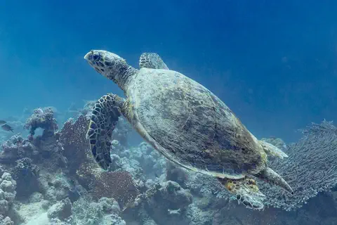
The hawksbill sea turtle lives in warm seas around the world, mostly near coral reefs. Its pointed, hawk-like beak reaches into cracks in the reef to find sponges, its favorite food. Its beautiful patterned shell once made it a target for hunters, and today it is critically endangered.
Explore next
-
 Watch
 Country
Saint Martin
Saint-Martin covers the northern two-thirds of the island of Saint Martin, in the northeastern Caribbean Sea. It is an overseas collectivity of France, and its capital is Marigot. The southern third of the same island is Sint Maarten, a country within the Kingdom of the Netherlands. INSEE, France's statistics office, counted 31,160 people in Saint-Martin.
-
 Watch
 Country
Netherlands
The Netherlands is a small, flat country in northwestern Europe on the North Sea. Its name means low-lying country: more than a quarter of it lies below sea level, protected by dunes and dikes. About 18.2 million people lived there in 2026, and its capital is Amsterdam, a city of canals.
-
 Watch
 Country
Curaçao
Curaçao is an island in the southern Caribbean, about 60 kilometers north of Venezuela. Since 2010 it has been a country within the Kingdom of the Netherlands. Its capital, Willemstad, is famous for colorful buildings around a deep natural harbor, now a World Heritage site, and the 2023 census counted 155,826 people.
-
 Watch
 Country
Anguilla
Anguilla is a low coral island in the eastern Caribbean, the most northerly of the Leeward Islands. Its long, thin shape gave it a name that comes from the French word for eel. It is a British overseas territory, famous for its white beaches, and the statistics office estimated 16,010 people at the end of 2024.
-
 Watch
 Country
Saint Barthélemy
Saint Barthélemy is a small island in the northeastern Caribbean Sea and an overseas collectivity of France. For almost a hundred years it belonged to Sweden, which is why its only town is called Gustavia. INSEE, France's statistics office, counted 10,660 people living there.
-
Watch
Animal
Leatherback sea turtle
The leatherback sea turtle is the largest turtle on Earth. Instead of a hard shell it has tough, rubbery skin over a layer of tiny bones. It eats jellyfish, dives deeper than any other turtle and swims thousands of kilometers between feeding waters and the beaches where it lays its eggs.
-
Watch
3D
Animal
Hawksbill sea turtle
The hawksbill sea turtle lives in warm seas around the world, mostly near coral reefs. Its pointed, hawk-like beak reaches into cracks in the reef to find sponges, its favorite food. Its beautiful patterned shell once made it a target for hunters, and today it is critically endangered.
- Watch Geography Islands An island is a piece of land surrounded by water that is smaller than a continent. Islands form in different ways: some broke away from continents, some were built by volcanoes on the sea floor, and some were made by corals or by waves piling up sand. Because they are cut off by water, islands often have unusual plants and animals.
For parents & teachers
What children will learn
- Locate Sint Maarten on the island of Saint Martin in the northeastern Caribbean.
- Explain how one island can be shared by two countries.
- Describe how a marine park and dark beaches protect sea life.
- Outline how Sint Maarten became a country within the Kingdom of the Netherlands.
Recommended ages: 3 to 17 · About 15 minutes
Talk about it
- One island has two parts with different languages and money. What might be the same, and what might be different, for children on each side?
- Why might bright lights on a beach confuse a sea turtle?
- Fishing is not allowed in the marine park. How could that help the fish outside the park too?
Try at home or in class
- Draw an island divided into two parts, label each part and its main town, and add a dotted line for the border.
- Make a 'turtle-friendly beach' poster with three tips: keep lights off, give turtles space, leave hatchlings alone.
Key vocabulary: constituent country, salt pan, marine park, partition, nesting season
Where these facts come from
- Wikidata , Wikimedia Foundation (CC0 1.0)
- Natural Earth vector data , Natural Earth (NACIS) (Public domain)
- Sint Maarten , Encyclopaedia Britannica
- Saint Martin (island, West Indies) , Encyclopaedia Britannica
- Saint-Martin (overseas collectivity, France) , Encyclopaedia Britannica
- Rebased Population Estimates and Vital Statistics for January 1, 2025 , Government of Sint Maarten, Department of Statistics
- Man of War Shoal Marine Park , Nature Foundation Sint Maarten
- Sint Maarten hopes for a more respectful sea turtle nesting season in 2026 , Nature Foundation Sint Maarten
- Nature Foundation backs plan for Sint Maarten's first terrestrial park , Nature Foundation Sint Maarten
- First island-wide assessment of Saint Martin's iconic Pope's head cactus completed , Nature Foundation Sint Maarten
- Currency Notes: Making Waves , International Monetary Fund, Finance & Development
- PlayOwl region table, version 1 , PlayOwl (PlayOwl original data)
- flag-icons 7.5.0 , Panayiotis Lipiridis and contributors (MIT)
- Wikimedia Commons , Wikimedia Foundation (Per file (public domain, CC0, CC BY or CC BY-SA); see each media record)
Checked, not yet human-reviewed. Last updated November 1, 2026. Spotted a mistake? Tell us.