
 Country
Africa
Saint Helena, Ascension and Tristan da Cunha
Saint Helena, Ascension and Tristan da Cunha are islands far out in the South Atlantic Ocean. They are made by volcanoes. Sea turtles, penguins and many seabirds live there.
This British overseas territory is made of three groups of volcanic islands spread across the South Atlantic Ocean: Saint Helena, Ascension and Tristan da Cunha. Saint Helena lies about 1,950 kilometers west of Africa, and Tristan da Cunha is some 2,100 kilometers farther south. About 5,400 people lived on the three island groups in 2023.
Saint Helena, Ascension and Tristan da Cunha is a British overseas territory of three volcanic island groups spread across the South Atlantic. Under the 2009 constitution the three are equal parts sharing one governor, based on Saint Helena, with separate legislatures. Estimates for March 2023 total 5,391 residents: 4,233 on Saint Helena, 894 on Ascension and 264 on Tristan da Cunha.
Photo: Andrew Neaum, CC BY-SA 3.0, via Wikimedia Commons
Discover three far-apart islands
These islands are very far from other land.
There are three of them, and they are far from each other too.
Saint Helena lies in the South Atlantic Ocean, about 1,950 kilometers west of the southwest coast of Africa. Ascension Island is about 1,100 kilometers to its northwest, and the Tristan da Cunha islands are about 2,100 kilometers to its south.
Together they make one British overseas territory. Since 2009 the three have been equal parts, each with its own council, sharing one governor who represents the British monarch and lives on Saint Helena.
Britannica places Saint Helena about 1,950 km west of southwestern Africa, with Ascension about 1,100 km to the northwest and the Tristan da Cunha group some 2,100 km to the south. The Tristan group lies about midway between southern Africa and South America; its sixth island, Gough, is about 320 km south-southeast of the others.
The 2009 constitution made Ascension and Tristan da Cunha equal parts of the territory rather than dependencies of Saint Helena. All three share a governor, appointed by the monarch and resident on Saint Helena, but have separate legislatures; administrators represent the governor on Ascension and Tristan. The British Overseas Territories Act of 2002 gave British citizenship to the people of the overseas territories, including these islands.
Jamestown, Georgetown and Edinburgh of the Seven Seas
Jamestown sits in a narrow valley between tall, dark cliffs.
Small boats float in the bay in front of it.
Jamestown is Saint Helena's capital and only port. Ships can land only at James Bay, on the northwest side, and the town fills a narrow valley that runs inland from the bay. In the photo, small boats float in the bay below two steep, dark hillsides, with the town tucked between them.
Napoleon lived his last years at Longwood House, inland. Georgetown is the main settlement on Ascension, and Edinburgh of the Seven Seas is the only settlement on Tristan da Cunha.
Britannica describes James Bay, on Saint Helena's northwestern side, as the island's only practicable landing place; a narrow valley runs 2.4 km inland from it, and Jamestown, the capital, port and only town, lies in that valley. The island also has an airport on Prosperous Bay Plain near the east coast and Longwood House, where Napoleon was confined from 1815 to 1821.
On Ascension, Georgetown is the main settlement and the seat of the administration. On Tristan da Cunha, Edinburgh of the Seven Seas, often shortened to Edinburgh, is the only permanent settlement, on the island's largest lowland strip along the north coast; the islands' website calls it the world's most isolated settlement. The photo shows small boats in James Bay below steep volcanic slopes, with Jamestown's houses in the valley.
Volcanoes, cliffs and a heart-shaped lake
All these islands were made by volcanoes.
Tristan da Cunha has a tall volcano with a lake shaped like a heart at the top.
Saint Helena is an old volcano that no longer erupts. Cliffs 490 to 700 meters high rise around much of it, and its highest point, Diana's Peak, is 820 meters. The weather is mild, with warm summers and slightly cooler winters.
Ascension is mostly a desert of old craters and lava flows, except on the heights of Green Mountain. Tristan da Cunha is an active volcano. Its summit, Queen Mary's Peak, rises 2,062 meters, and its crater holds a heart-shaped lake.
Saint Helena is volcanic but extinct, with cliffs of 490 to 700 m on its eastern, northern and western sides and a semicircular rim of mountains including Diana's Peak (820 m) and Mount Actaeon (800 m); rainfall ranges from about 200 mm at sea level to more than 760 mm in the center (Britannica). Ascension is mostly a desert of dormant craters and lava flows, except on the heights of Green Mountain (859 m), and it has no surface streams.
Tristan da Cunha, described by its government's website as an active volcanic island, rises to Queen Mary's Peak (2,062 m), a cone of loose ash and cinders whose summit crater holds a heart-shaped lake; the site notes heavy rain has probably lowered the peak by some 200 m through gully erosion. About 1,675 mm of rain falls each year at Edinburgh. In October 1961 an eruption threatened the settlement and the islanders were moved to England; 198 returned in November 1963.
Wirebirds, nesting turtles and seabird islands
Green sea turtles lay eggs on Ascension's sandy beaches.
Saint Helena has a small bird with long, thin legs called the wirebird.
The wirebird is the only bird found nowhere else that still lives on Saint Helena. It is named for its thin legs, and it appears on the island's flag. Saint Helena also has plants found nowhere else, such as the Saint Helena ebony and redwood.
On Ascension, green turtles come ashore to lay eggs from January to April, and sooty terns nest in large numbers. Since the island's wild cats were removed, seabirds such as boobies and red-billed tropicbirds have begun to return to the island. The tropicbird in the photo was photographed in the Galápagos Islands.
JNCC describes the wirebird, or St Helena plover (Charadrius sanctaehelenae), as the island's only remaining endemic bird, classed as Vulnerable, featured on the flag and estimated at around 545 adults; camera traps showed cats behind over 60% of nest predation events. Britannica names endemic plants such as the St Helena ebony, redwood and black cabbage trees, and small animals such as blushing snails.
On Ascension, green turtles nest from January to April, sooty terns breed in abundance, and after feral cats were eradicated early this century, masked and brown boobies and red-billed tropicbirds began recolonizing the main island (Britannica). In August 2019 a marine protected area covering all of Ascension's 445,000 km² exclusive economic zone was designated, under which commercial fishing and mineral extraction are to be prohibited. Gough and Inaccessible Islands, a UNESCO World Heritage site, hold endemic land birds, plants and invertebrates; Inaccessible's endemic rail is small and flightless. The tropicbird pictured was photographed at Plaza Sur, Galápagos.

Saints, islanders and island workers
Only a few thousand people live on these islands.
They speak English.
About 5,400 people lived across the three island groups in March 2023, most of them on Saint Helena. Saint Helena's statistics office estimated 3,980 residents there in June 2025 (a provisional figure). Tristan da Cunha's website listed about 220 islanders in 2026.
On Saint Helena, English is the language spoken. Britannica describes its people as being of mixed European, mostly British, South and East Asian, and African descent. On Tristan, the first families were soldiers who stayed after 1817, shipwrecked sailors, settlers from Europe and women from Saint Helena.
Estimates for 31 March 2023, mostly from the St Helena Statistics Office (via City Population), give 4,233 on Saint Helena, 894 on Ascension and 264 on Tristan da Cunha, 5,391 in all; the February 2021 census counted 4,439, 1,023 and 260. The Statistics Office's provisional estimate for Saint Helena in June 2025 is 3,980; it cannot yet issue later figures because of a data problem. Tristan's website listed 220 islanders with residency status in October 2026.
Britannica describes Saint Helena's population as of mixed European (mostly British), South and East Asian, and African descent, and English-speaking. Tristan's community grew from three garrison members who stayed in 1817, joined by shipwrecked sailors, European settlers and women from Saint Helena; there were 97 inhabitants by 1886. From the early 1960s, jobs at Ascension's telecommunications center brought Saint Helena workers a degree of prosperity.
Ships, a famous exile and a volcano
Long ago, sailing ships stopped at Saint Helena for food and water.
A famous French leader, Napoleon, once lived there.
A navigator sailing for Portugal, João da Nova, found Saint Helena in 1502. It became a stop for ships sailing between Europe and the East Indies, and in 1659 the English East India Company took it over. Enslaved people were brought to the island, and all were freed between 1826 and 1836.
Napoleon, the French emperor, was kept on Saint Helena from 1815 until his death in 1821. Ascension had no people until British marines arrived in 1815, and Tristan da Cunha became British in 1816.
Saint Helena was discovered in May 1502 by João da Nova, a navigator in Portuguese service, and became a port of call between Europe and the East Indies after Thomas Cavendish's visit in 1588. The English East India Company took possession in 1659. By 1673 nearly half the inhabitants were enslaved people brought to the island; all were freed between 1826 and 1836. Napoleon was confined at Longwood House from October 1815 until his death in May 1821; crown rule followed in 1834, and the island's trade faded after steamships and the Suez Canal (1869) changed sea routes.
Ascension, reached by João da Nova in 1501, stayed uninhabited until British marines were stationed there in 1815. Tristão da Cunha discovered the Tristan group in 1506; Britain annexed it in 1816. A 2009 constitution made the three islands equal parts of one territory.
The islands on the map
Find Africa on the globe.
Look far out in the ocean to its west. The islands are tiny dots in the big blue sea.
Ascension lies about 8 degrees south of the equator, Saint Helena about 16 degrees south, and Tristan da Cunha about 37 degrees south. All three are in the South Atlantic Ocean, between Africa and South America.
The islands are too small for the globe to draw, so PlayOwl marks places with dots: Jamestown, Longwood House, Diana's Peak, Georgetown, Edinburgh of the Seven Seas, Queen Mary's Peak and Gough Island.
Jamestown lies at about 15.9° S, 5.7° W; Georgetown, Ascension, at about 7.9° S, 14.4° W; Edinburgh of the Seven Seas at about 37.1° S, 12.3° W. The territory has no land borders.
At the globe's scale the islands have no outlines, so the map uses markers: Jamestown, Longwood House and Diana's Peak on Saint Helena; Georgetown on Ascension; Edinburgh of the Seven Seas and Queen Mary's Peak on Tristan da Cunha; and Gough Island, about 320 km south-southeast of Tristan.
- Saint Helena to Africa
- about 1,950 km
- People (March 2023, estimates)
- 5,391
- Queen Mary's Peak, Tristan da Cunha
- 2,062 m
- Ascension marine protected area
- over 445,000 km²
Amazing facts
-
A volcano on Tristan da Cunha has a heart-shaped lake on top.
The crater at the top of Queen Mary's Peak, 2,062 meters up, holds a lake shaped like a heart.
Queen Mary's Peak (2,062 m) is a classic volcanic cone whose summit crater contains a heart-shaped lake.
-
The wirebird is named for its thin legs.
Saint Helena's wirebird was first called the veerbird, because it runs to the side; its name changed because of its thin, wiry legs.
The St Helena plover was originally the 'veerbird', for its sideways running, before 'wirebird' took over from its slender legs; it features on the island's flag.
-
Nobody lived on Ascension until 1815.
Ascension Island had no people until 1815, when British marines were sent there while Napoleon was held on Saint Helena.
Ascension remained uninhabited until 1815, when British marines were stationed there during Napoleon's exile to prevent the French from claiming it.
-
One tiny island has a bird that cannot fly.
Inaccessible Island, near Tristan da Cunha, is home to a small rail that cannot fly and lives nowhere else.
Inaccessible Island, ringed by cliffs some 300 m high, has an endemic small flightless land rail.
Words to know
- overseas territory
- a place far from a country's main land that the country is responsible for
- exile
- being sent away from your home country and made to live somewhere else
- crater
- the bowl-shaped hollow at the top of a volcano
- endemic
- found naturally in one place and nowhere else
- marine protected area
- a part of the sea where fishing and other activities are limited to protect wildlife
Discovery challenge
-
Which famous French leader once lived on Saint Helena?
Which French emperor was held on Saint Helena from 1815 until 1821?
Who was confined at Longwood House on Saint Helena from 1815 until his death in 1821?
- Napoleon
- Charlemagne
- Louis XIV
Show the answer
Napoleon
Napoleon!
Napoleon, who lived at Longwood House.
Napoleon I, at Longwood House, October 1815 to May 1821.
-
Which island has the tallest volcano, with a heart-shaped lake on top?
On which island is Queen Mary's Peak, 2,062 meters high?
Which island of the territory rises to Queen Mary's Peak, 2,062 m?
- Saint Helena
- Ascension
- Tristan da Cunha
Show the answer
Tristan da Cunha
Tristan da Cunha.
Tristan da Cunha. Saint Helena's highest point is only 820 meters.
Tristan da Cunha; Saint Helena's Diana's Peak is 820 m and Ascension's Green Mountain 859 m.
-
Which animals lay eggs on Ascension's beaches?
Which animals come ashore on Ascension from January to April to lay eggs?
For which endangered animals are Ascension's beaches critical nesting sites?
- Green sea turtles
- Crocodiles
- Emperor penguins
Show the answer
Green sea turtles
Green sea turtles.
Green sea turtles, from January to April.
Green turtles, which nest there from January to April.
-
What is Saint Helena's special little bird called?
What is the only remaining bird found nowhere else but Saint Helena?
Which plover is Saint Helena's only remaining endemic bird?
- The dodo
- The wirebird
- The kiwi
Show the answer
The wirebird
The wirebird.
The wirebird, named for its thin legs.
The wirebird, or St Helena plover, classed as Vulnerable.
Animals of Saint Helena, Ascension and Tristan da Cunha
-
 Watch
Animal
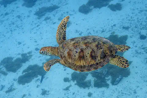
Green sea turtle
The green sea turtle is the largest sea turtle with a hard shell. It lives in warm seas around the world and, unlike other sea turtles, grown-ups eat mostly seagrass and algae. Females swim hundreds or even thousands of kilometers to lay their eggs on the beaches where they hatched long ago.
-
Watch
Animal
Red-billed tropicbird
The red-billed tropicbird is a white seabird with a red bill, black bars on its back and long tail streamers. It spends most of its life over warm tropical seas, where it dives for flying fish and squid. It comes to land to nest in rock crevices on small islands and cliffs.
Explore next
-
 Watch
 Country
United Kingdom
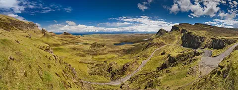
The United Kingdom, or UK, lies on islands off the northwest coast of Europe. It is made up of four parts, England, Scotland, Wales and Northern Ireland, and about 69.5 million people live there. Its capital is London.
-
 Watch
 Country
Falkland Islands
The Falkland Islands lie in the South Atlantic, about 480 kilometers northeast of the tip of South America. They are a British Overseas Territory, and Argentina also claims them, calling them the Islas Malvinas. Several million penguins breed there. The 2021 census counted 3,662 people who usually live on the islands.
-
Watch
Animal
Green sea turtle
The green sea turtle is the largest sea turtle with a hard shell. It lives in warm seas around the world and, unlike other sea turtles, grown-ups eat mostly seagrass and algae. Females swim hundreds or even thousands of kilometers to lay their eggs on the beaches where they hatched long ago.
-
Watch
Animal
Red-billed tropicbird
The red-billed tropicbird is a white seabird with a red bill, black bars on its back and long tail streamers. It spends most of its life over warm tropical seas, where it dives for flying fish and squid. It comes to land to nest in rock crevices on small islands and cliffs.
- Watch Geography Islands An island is a piece of land surrounded by water that is smaller than a continent. Islands form in different ways: some broke away from continents, some were built by volcanoes on the sea floor, and some were made by corals or by waves piling up sand. Because they are cut off by water, islands often have unusual plants and animals.
- Watch Geography Types of volcanoes Volcanoes come in different shapes. Runny lava builds wide, gentle shield volcanoes like Mauna Loa. Sticky lava and ash build tall, steep stratovolcanoes like Mount Fuji. Small cinder cones grow from bits of lava thrown into the air. Whether lava is runny or sticky, and how much gas it holds, decides the shape and how explosive the eruptions are.
-
 Watch
 Country
Democratic Republic of the Congo
The Democratic Republic of the Congo, or DR Congo, is the second-largest country in Africa. The mighty Congo River curves through its rainforests, volcanoes rise in the east, and its capital, Kinshasa, is a center of music, fashion and popular culture.
-
 Watch
 Country
Ethiopia
Ethiopia is a country on the Horn of Africa with no coast. Much of it is high, rugged land cut by the Great Rift Valley, it is one of the world's oldest countries, and more than 110 million people live there.
For parents & teachers
What children will learn
- Locate Saint Helena, Ascension and Tristan da Cunha in the South Atlantic.
- Explain how volcanoes built remote ocean islands.
- Describe how removing introduced predators helps island seabirds.
- Explain why remote islands were important stops for sailing ships.
Recommended ages: 3 to 17 · About 15 minutes
Talk about it
- How might daily life be different on an island that ships visit only a few times a year?
- Why do you think cats and rats cause so much trouble for birds on islands?
- Sailing ships once stopped at Saint Helena on long voyages. Why did fewer stop after steamships and the Suez Canal?
Try at home or in class
- On a printed map, measure how far Saint Helena, Ascension and Tristan da Cunha are from each other using the map's scale bar.
- Make a paper model of a volcano with a small heart-shaped 'lake' in its crater, and label the crater, slopes and lowland.
Key vocabulary: overseas territory, exile, crater, endemic, marine protected area
Where these facts come from
- Wikidata , Wikimedia Foundation (CC0 1.0)
- Natural Earth vector data , Natural Earth (NACIS) (Public domain)
- Saint Helena , Encyclopaedia Britannica
- History of Saint Helena , Encyclopaedia Britannica
- Ascension , Encyclopaedia Britannica
- Tristan da Cunha , Encyclopaedia Britannica
- Statistical Update: Population , St Helena Government, Statistics Office
- St. Helena, Ascension and Tristan da Cunha: islands and places , City Population (Thomas Brinkhoff), from the St Helena Statistics Office
- Ascension Island Marine Protected Area , Ascension Island Government
- Queen Mary's Peak , Tristan da Cunha Government and Tristan da Cunha Association
- Tristan da Cunha population , Tristan da Cunha Association
- Tristan da Cunha (home) , Tristan da Cunha Government and Tristan da Cunha Association
- The Wirebird: a symbol of conservation and hope , JNCC (Joint Nature Conservation Committee)
- Gough and Inaccessible Islands , UNESCO World Heritage Centre
- PlayOwl region table, version 1 , PlayOwl (PlayOwl original data)
- flag-icons 7.5.0 , Panayiotis Lipiridis and contributors (MIT)
- Wikimedia Commons , Wikimedia Foundation (Per file (public domain, CC0, CC BY or CC BY-SA); see each media record)
Checked, not yet human-reviewed. Last updated November 1, 2026. Spotted a mistake? Tell us.