
 Country
Europe
Serbia
Serbia is a country in southeastern Europe with big rivers, green hills and flat farmland. Its capital city is Belgrade.
Serbia is a landlocked country in the Balkans. Its north is flat farmland, its middle is wooded hills, and its edges have mountains, while the Danube River cuts a deep gorge called the Iron Gate. About 6.5 million people lived there in 2025.
Serbia is a landlocked country of the west-central Balkans, drained almost entirely to the Danube and the Black Sea. Its statistics office estimated 6,549,901 people in 2025, and its history runs from Roman palaces and the medieval Nemanjić state through Ottoman rule and Yugoslavia to independence on its own in 2006.
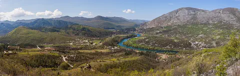
Photo: Bestalex, CC BY-SA 4.0, via Wikimedia Commons
Discover Serbia
Serbia is a country in Europe.
It has no sea coast. Big rivers flow across it. The capital city is called Belgrade.
Serbia is a landlocked country in the Balkans, the big peninsula in southeastern Europe. It has no coast, but it has great rivers: the Danube flows across the north and east, and almost all of Serbia's rivers drain into it.
The north of Serbia is flat, rich farmland. The middle is covered with wooded hills, and mountains rise along its western and eastern edges. About 6.5 million people lived in Serbia in 2025, and the capital, Belgrade, stands where the Sava River meets the Danube.
Serbia is a landlocked country in the west-central Balkans. Its landforms fall into regional groups: the low plains of Vojvodina in the north, the Šumadija hills in the center (the core of the medieval Serbian state), parts of the Dinaric Alps in the west, and the Carpathian and Rhodope mountain systems in the east. Nearly all of its drainage goes to the Danube and on to the Black Sea.
For most of the 20th century Serbia was part of Yugoslavia; it has been an independent state on its own since 2006. The Statistical Office of the Republic of Serbia estimated the population at 6,549,901 in 2025, based on the 2022 census; its estimates have included no data for Kosovo and Metohija since 1999.
Cities and famous places
Belgrade is the capital and the biggest city.
It is where two big rivers meet. An old fortress stands above the rivers. Its name means white city.
Belgrade, the capital, stands where the Sava River flows into the Danube. Its name, Beograd, means "white city" or "white fortress," after a fortress built on a white ridge. The old Kalemegdan fortress is now a historic monument with a garden, and more than a million people live in the city.
Novi Sad, Serbia's second city, lies upstream on the Danube. In central Serbia, Studenica Monastery, founded in the late 1100s, has two churches built of white marble. In the east, the ruins of a Roman palace called Felix Romuliana still stand near Gamzigrad.
Belgrade grew around a fortress on the Kalemegdan headland, bounded on three sides by the Sava and the Danube; the Celts built the first fortress in the 4th century BCE, and the Romans knew it as Singidunum. It came under Serbian rule in 1284, became the capital in 1402, was held by the Ottomans after 1521 (except three Austrian periods), and became the capital again in 1867; from 1921 it was the capital of three successive Yugoslav states. It sits where routes along the Danube, the Sava and the Morava–Vardar valleys meet, and its university was founded in 1863.
Studenica Monastery, founded in the late 12th century by Stefan Nemanja, is described by UNESCO (inscribed 1986) as the largest and richest of Serbia's Orthodox monasteries; its Church of the Virgin and Church of the King, both of white marble, hold 13th- and 14th-century Byzantine paintings. Gamzigrad-Romuliana (inscribed 2007) is a late 3rd- and early 4th-century Roman palace compound commissioned by Emperor Galerius and named Felix Romuliana after his mother.
Rivers, plains and mountains
The Danube is a very long river.
In Serbia, it squeezes through a deep, rocky gorge. The north is flat and good for farming. Mountains stand in the west and the east.
On Serbia's northeastern border, the Danube flows for about 100 kilometers through the Iron Gate, or Đerdap, a deep gorge through the Carpathian mountains. Upstream, on the flat Vojvodina plains, the river can be up to 3 kilometers wide. The Velika Morava, 470 kilometers long, is the largest river entirely inside Serbia.
The Vojvodina plains lie only 60 to 100 meters above sea level and have rich black soil. In the southwest, the Kopaonik Mountains reach 2,017 meters, and a peak in the Balkan Mountains on the Bulgarian border rises above 2,100 meters. Serbia has cold, fairly dry winters and warm, humid summers.
Britannica calls the Iron Gate (Đerdap) gorge on the northeastern border the most spectacular such feature in Europe: for 100 km the Danube crosses the Carpathians, its bed dropping 30 m, through four narrow constrictions joined by three basins. Before the joint Yugoslav-Romanian Đerdap hydroelectric dam was completed in 1972, rocks narrowed the river at one point to 90 m. The Velika Morava (470 km) drains two-fifths of the country; its valley and the Vardar's have been a route between central Europe and the eastern Mediterranean since prehistoric times. Apart from reservoirs, Serbia has no sizable lakes.
Vojvodina's plains (60–100 m) carry chernozem soils formed from the roots of countless generations of grasses, and loess left by winds in the last glacial period. The granite Kopaonik ridge (2,017 m) lies in a tectonically active zone. The climate is continental: Vojvodina averages about 22 °C in July and −1 °C in January, precipitation ranges from 560 to 1,900 mm, and snow covers the ground for about 40 days in the northern lowlands and 120 in the mountains.
Forests and wildlife
Deer and bears live in Serbia's forests.
Wild pigs live in the beech forests. Lynx live in the eastern mountains. They have tufts on their ears.
Up to one-third of central Serbia is covered by broad-leaved forest, mostly oak and beech. The region name Šumadija even means "forested area," although much of it has been cleared for farms. Deer and bears are common in the forests, and wild pigs are a special feature of the mountain beech forests.
Serbia's national parks include Kopaonik and Tara in the southwest, Đerdap beside the Iron Gate, and Fruška Gora in Vojvodina. In Đerdap, lynx hunt roe deer, mountain goats and rabbits. Lynx are strictly protected, and hunting them is not allowed.
Serbia's vegetation forms a transition between central European and Mediterranean types. Before Austrian farm colonization in the 18th century, the Vojvodina plains were grassland steppe; only about 5 percent of the province is now wooded, mostly on Fruška Gora and in wetlands along the Danube and Sava. Up to one-third of Serbia proper is broad-leaved forest, mostly oak and beech, rising to two-fifths or more in the mountains. Deer and bears abound in the forests, and wild pigs (Sus scrofa) are a distinctive feature of the mountain beech forests.
Its national parks include Kopaonik and Tara in the southwestern mountains, Đerdap beside the Iron Gate and Fruška Gora in Vojvodina. Đerdap stretches 100 km along the Danube's right bank; there the Eurasian lynx, which preys mostly on roe deer, mountain goats and rabbits, is strictly protected, the beech forest on Šomrda is the northernmost habitat of holly in Serbia, and the rare bear hazel, a relict tree that can grow 30 m tall, survives in protected sites.
People, language and farming
About six and a half million people live in Serbia.
Most people speak Serbian. Serbian is written with Cyrillic letters. Farmers grow corn, wheat, plums and raspberries.
About 6.5 million people lived in Serbia in 2025, and more than half live in towns and cities. Most people are Serbs. Hungarians and Bosniaks are the largest minorities, and Roma, Croats, Montenegrins, Bulgarians and Romanians live in Serbia too.
Serbian is very close to Croatian, Bosnian and Montenegrin, but it is usually written in its own version of the Cyrillic alphabet. Corn covers about a third of the farmland, and wheat comes next. Plum orchards are common in the hills, and raspberries have become an important crop. A folk dance called the kolo is danced by people of all ages in towns and villages.
The Statistical Office's 2025 estimate was 6,549,901 people, 51.3 percent of them women. More than four-fifths identify as Serbs; the principal minorities are Hungarians and Bosniaks, and Roma, Croats, Montenegrins, Bulgarians and Romanians also live there. In Vojvodina, Serbs make up slightly more than half of an exceptionally diverse population. Only one-fifth of Serbs were urban in 1948; by the early 21st century more than half of the population lived in cities. Serbian national identity is tied to an Eastern Orthodox Christian heritage, while Vojvodina's Hungarians are Roman Catholic or Calvinist.
Serbian, Croatian, Bosnian and Montenegrin are essentially one language, linguistically termed Serbo-Croatian; Serbian is distinguished in writing by a modified Cyrillic alphabet. Agriculture has shifted from livestock toward crops: corn occupies about one-third of the cropland, followed by wheat, with sugar beets, sunflowers and potatoes; plum orchards characterize the uplands, and raspberries grown for western European markets have become important. Kolo, a folk dance danced by all age groups in towns and villages, was inscribed by UNESCO in 2017; its oldest recorded versions come from central Serbia in the second half of the 19th century.
A long history
People have lived in Serbia for a very long time.
Long ago, a Roman emperor built a palace there. Later, Serbian rulers built monasteries. Since 2006, Serbia has been a country all on its own.
By the late 600s, Slavic peoples, including the Serbs, had settled across the Balkans. In 1168 Stefan Nemanja took the throne, and his family, the Nemanjić dynasty, ruled a powerful Serbian state for about 200 years. They built monasteries such as Studenica.
From the 1400s, the Ottoman Empire ruled Serbia for centuries. In the 1800s Serbia won back its self-rule step by step: in 1830 it gained full autonomy, and in 1867 Belgrade became its capital again. In 1918 Serbia joined other South Slav lands in a new kingdom, called Yugoslavia from 1929. In the 1990s several republics left Yugoslavia, and in 2006 Serbia became an independent country on its own.
The earliest information on the Serbs dates from the late 6th century; the first state to which Serbs attach a political identity was created by Vlastimir about 850, in Raška. A stable state emerged under Stefan Nemanja, who took the throne in 1168; his son Stefan the First-Crowned was made king in 1217, an independent church was declared in 1219, and under Stefan Dušan (1331–55) the Nemanjić state reached its greatest extent. Serbian resistance to the Ottomans ended with the fall of Smederevo in 1459. An uprising in Šumadija in 1804, led by Karadjordje, began the wars of 1804–15; the Ottoman government granted the principality full autonomy in 1830, and Belgrade became the capital again in 1867.
In 1918 Serbia joined the Kingdom of Serbs, Croats and Slovenes, constituted as Yugoslavia in 1929. The breakup of Yugoslavia in the early 1990s brought civil war and international sanctions. In 1998–99 armed conflict in Kosovo, then a province of Serbia, was followed by NATO air strikes and, from June 1999, UN administration of Kosovo. Serbia and Montenegro replaced Yugoslavia in 2003 and became separate independent states in 2006. Kosovo declared independence in February 2008, with the support of the United States and the EU; Serbia, backed by Russia, China and several EU members, refused to recognize Kosovo as a sovereign country, and recognition by other countries varies. In 2013 Serbia and Kosovo agreed to normalize relations, although Serbia stopped short of recognizing Kosovo's independence.
Serbia on the map
Find Serbia on the globe.
It is in southeastern Europe. It has no sea coast. Look for the long Danube River flowing through it.
Serbia is in the Balkans, in southeastern Europe. Its neighbors include Hungary to the north, Romania and Bulgaria to the east, North Macedonia to the south, Montenegro to the southwest, and Bosnia and Herzegovina and Croatia to the west.
For part of its length, the Danube forms Serbia's border with Romania as it flows through the Iron Gate gorge. Almost all of Serbia's rivers drain to the Danube, which carries their water to the Black Sea.
Serbia is bounded on the west by Bosnia and Herzegovina and the Slavonian region of Croatia, on the north by Hungary, on the east by Romania and Bulgaria, on the south by North Macedonia and on the southwest by Montenegro. Britannica adds that Kosovo, which Serbia does not recognize as an independent country, also lies to the south, along Albania's northeastern border.
Serbia's size and highest point depend on whether Kosovo is counted. The Statistical Office of the Republic of Serbia gives the total territory of the Republic as 88,499 km², a figure that includes Kosovo and Metohija (10,910 km²); without Kosovo the area is 77,589 km², the figure Britannica gives. The office's list of peaks, from the Military Geographical Institute, is headed by Velika Rudoka (2,660 m) in the Šar Mountains, a range in southern Kosovo and North Macedonia; outside Kosovo the highest peak on the list is Midžor (2,168 m) in the Stara Planina on the Bulgarian border.
The northeastern border follows the Iron Gate gorge of the Danube. The Tisa enters Vojvodina from Hungary, the Sava joins the Danube at Belgrade, and the Morava flows north into the Danube, while a few tributaries of the Vardar in the southeast flow south across North Macedonia to the Aegean Sea.
- Coastline
- none (landlocked)
- Iron Gate gorge of the Danube
- about 100 km
- Largest river entirely in Serbia
- Velika Morava, 470 km
- Vojvodina plains
- 60 to 100 m above sea level
- Total territory, including Kosovo and Metohija (Statistical Office of Serbia)
- 88,499 km²
- Area without Kosovo (Britannica)
- 77,589 km²
- Highest listed peak, including Kosovo (Statistical Office of Serbia)
- Velika Rudoka, 2,660 m
- Highest listed peak outside Kosovo (Statistical Office of Serbia)
- Midžor, 2,168 m
Amazing facts
-
Belgrade's name means white city.
Belgrade is called Beograd in Serbian: beo means "white" and grad means "city."
Beograd means "white city" or "white fortress"; the city is named for its fortress, built on a white ridge of great strategic importance.
-
The Danube in Serbia can be very, very wide.
On the Vojvodina plains, the Danube can be up to 3 kilometers wide and 14 meters deep or more.
Upstream of the Iron Gate, on the Vojvodina plains, the Danube reaches widths of up to 3 km and depths of 14 m or more.
-
Šumadija means forest land.
The name of the Šumadija region in central Serbia means "forested area," although much of it is now farmland.
Šumadija literally means "forested area," but large formerly wooded areas were long ago cleared and cultivated.
-
Serbia's biggest natural lake is quite small.
Apart from lakes behind dams, Serbia has no big lakes. Its largest natural one, Lake Palić, covers less than 5 square kilometers.
Other than reservoirs behind hydroelectric dams, Serbia has no appreciable lakes; Lake Palić in Vojvodina, the largest natural one, covers less than 5 km².
-
Two old churches in Serbia are made of white marble.
Studenica Monastery's two main churches are built of white marble and hold paintings from the 1200s and 1300s.
UNESCO describes Studenica's Church of the Virgin and Church of the King, both of white marble, as holding priceless 13th- and 14th-century Byzantine paintings.
Words to know
- landlocked
- having no coast on any sea or ocean
- gorge
- a deep, narrow valley with steep sides, often with a river
- plain
- a large area of flat land with few trees
- confluence
- the place where two rivers meet and join
- Cyrillic
- an alphabet used to write Serbian, Russian, Bulgarian and other languages
- autonomy
- the right of a place to govern itself
- World Heritage Site
- a place UNESCO lists as important to all people, to be protected
Discovery challenge
-
What is the capital city of Serbia?
Which city is the capital of Serbia?
Which city, at the confluence of the Sava and the Danube, is Serbia's capital?
- Novi Sad
- Niš
- Belgrade
Show the answer
Belgrade
Belgrade is the capital of Serbia.
Belgrade is the capital. Novi Sad is Serbia's second city, upstream on the Danube, and Niš is a city in the southeast.
Belgrade grew around the Kalemegdan fortress above the Sava–Danube confluence; it became Serbia's capital in 1402 and again in 1867.
-
Which big river flows through Serbia?
Which great river flows through the Iron Gate gorge on Serbia's border?
Which river crosses the Carpathians in the Iron Gate (Đerdap) gorge?
- The Danube
- The Nile
- The Amazon
Show the answer
The Danube
The Danube flows through Serbia.
The Danube flows through the Iron Gate, a gorge about 100 kilometers long on Serbia's border with Romania.
In the Iron Gate the Danube crosses the Carpathians for 100 km, its bed dropping 30 m through four narrow constrictions.
-
What does the name Belgrade mean?
Belgrade is Beograd in Serbian. What does that name mean?
What does Beograd, the Serbian name of the capital, mean?
- White city
- River town
- Green hill
Show the answer
White city
Belgrade means white city.
Beo means "white" and grad means "city"; the name comes from a fortress built on a white ridge.
Beograd means "white city" or "white fortress," after the fortress on a white ridge above the two rivers.
-
Which letters are used to write Serbian?
Which alphabet is Serbian usually written in?
Serbian is distinguished in writing from Croatian and Bosnian by which script?
- Arabic letters
- Cyrillic letters
- Chinese characters
Show the answer
Cyrillic letters
Serbian uses Cyrillic letters.
Serbian uses its own version of the Cyrillic alphabet, while Croatian is written in Latin letters.
Serbian uses a modified Cyrillic alphabet; Croatian uses the Latin script, and Bosnian, once also written in Arabic letters, has adopted Latin.
-
What is the north of Serbia like?
What is the Vojvodina region in the north of Serbia like?
Which description fits Vojvodina, Serbia's northern region?
- Flat farmland
- Snowy high mountains
- Sandy desert
Show the answer
Flat farmland
The north is flat. Farmers grow lots of food there.
Vojvodina is a flat plain only 60 to 100 meters above sea level, with rich black soil for farming.
Vojvodina's plains lie at 60–100 m and carry fertile chernozem soils; before 18th-century colonization they were grassland steppe.
Places to discover in Serbia
-
Watch
City
Belgrade
Belgrade, the capital of Serbia, stands where the Sava River flows into the Danube. Its name, Beograd, means "white city", probably because of the white limestone walls of its old fortress above the rivers. At the 2022 census, about 1.2 million people lived in the city itself and about 1.7 million in the wider City of Belgrade.
-
 Watch
Natural wonder
Danube
The Danube is Europe's second-longest river, after the Volga. It begins as two small streams in Germany's Black Forest and flows about 2,850 kilometers east to the Black Sea, passing through 10 countries and four capital cities. For more than 2,000 years it has been a border, a highway for boats and a home for wildlife, and it ends in a giant delta of reeds, lakes and birds.
Animals of Serbia
-
 Watch
Animal
Eurasian lynx
The Eurasian lynx is the largest of the four kinds of lynx. It has black ear tufts, a ruff of fur around its face, a short black-tipped tail and big furry paws for snow. It hides in forests and ambushes deer such as roe deer, and it has returned to parts of Europe where it had disappeared.
-
 Watch
3D
Animal
Brown bear
The brown bear lives in more places than any other bear, from European forests to the mountains of Asia and the rivers of Alaska. It eats almost anything, from berries to salmon, and spends the long winter asleep in a cozy den. Grizzly bears and Kodiak bears are brown bears too.
-
 Watch
3D
Animal
Wild boar
Wild boars are bristly wild pigs that live in forests and fields across Europe, Asia and North Africa. They sniff out food with their powerful snouts, live in family groups called sounders, and are the wild ancestors of farm pigs.
Explore next
-
Watch
City
Belgrade
Belgrade, the capital of Serbia, stands where the Sava River flows into the Danube. Its name, Beograd, means "white city", probably because of the white limestone walls of its old fortress above the rivers. At the 2022 census, about 1.2 million people lived in the city itself and about 1.7 million in the wider City of Belgrade.
-
Watch
Natural wonder
Danube
The Danube is Europe's second-longest river, after the Volga. It begins as two small streams in Germany's Black Forest and flows about 2,850 kilometers east to the Black Sea, passing through 10 countries and four capital cities. For more than 2,000 years it has been a border, a highway for boats and a home for wildlife, and it ends in a giant delta of reeds, lakes and birds.
-
Watch
Animal
Eurasian lynx
The Eurasian lynx is the largest of the four kinds of lynx. It has black ear tufts, a ruff of fur around its face, a short black-tipped tail and big furry paws for snow. It hides in forests and ambushes deer such as roe deer, and it has returned to parts of Europe where it had disappeared.
-
Watch
3D
Animal
Brown bear
The brown bear lives in more places than any other bear, from European forests to the mountains of Asia and the rivers of Alaska. It eats almost anything, from berries to salmon, and spends the long winter asleep in a cozy den. Grizzly bears and Kodiak bears are brown bears too.
-
Watch
3D
Animal
Wild boar
Wild boars are bristly wild pigs that live in forests and fields across Europe, Asia and North Africa. They sniff out food with their powerful snouts, live in family groups called sounders, and are the wild ancestors of farm pigs.
- Watch Geography Rivers from source to mouth A river is fresh water that flows downhill, pulled by gravity. It begins at a source, such as a spring, melting snow or a lake. Smaller streams called tributaries join it along the way, so it grows bigger, until it empties into a lake, a larger river or the ocean at its mouth.
-
 Watch
 Country
Belarus
Belarus is a landlocked country in eastern Europe. Ice sheets of the last ice age shaped its low hills and wide plains, it has more than 10,000 lakes and one of Europe's largest wetlands, and about 9.1 million people lived there in 2025.
-
 Watch
 Country
Bosnia and Herzegovina
Bosnia and Herzegovina is a mountainous country in southeastern Europe. It has forests, limestone hills and many rivers, and famous old stone bridges cross some of them. Its capital is Sarajevo. It touches the Adriatic Sea along only about 20 kilometers of coast.
For parents & teachers
What children will learn
- Locate Serbia in the Balkans and explain what landlocked means.
- Describe Serbia's three kinds of landscape and how the Danube shapes the country, including the Iron Gate.
- Describe Serbian language, farming and the kolo dance without treating them as one single culture.
- Outline Serbia's history from Roman times and the Nemanjić state to independence on its own in 2006.
Recommended ages: 3 to 17 · About 15 minutes
Talk about it
- Why might a capital city grow where two big rivers meet?
- How might building a dam change a river and the places along it?
- Serbian can be written in Cyrillic letters. What other alphabets have you seen?
Try at home or in class
- On a map, trace the Danube from Germany to the Black Sea and find where it passes Belgrade and the Iron Gate.
- Fill a tray with sand, pour water through a narrow gap between two blocks, and compare how fast it flows there and where the tray is wide.
Key vocabulary: landlocked, gorge, plain, confluence, Cyrillic, autonomy, World Heritage Site
Where these facts come from
- Wikidata , Wikimedia Foundation (CC0 1.0)
- Natural Earth vector data , Natural Earth (NACIS) (Public domain)
- UNESCO World Heritage List , UNESCO World Heritage Centre (Linked as a reference; site facts come from Wikidata)
- Serbia , Encyclopaedia Britannica
- Serbia: Drainage, soils, climate, plant and animal life , Encyclopaedia Britannica
- Serbia: People , Encyclopaedia Britannica
- Serbia: Economy , Encyclopaedia Britannica
- Serbia: The arts (cultural institutions, sports, national parks) , Encyclopaedia Britannica
- Serbia: History , Encyclopaedia Britannica
- Serbia: Conquest by the Ottoman Turks , Encyclopaedia Britannica
- Serbia: The disintegration of Ottoman rule , Encyclopaedia Britannica
- Serbia: Consolidation of the state , Encyclopaedia Britannica
- Serbia: Independent Serbia , Encyclopaedia Britannica
- Serbia: The Kosovo conflict , Encyclopaedia Britannica
- Belgrade , Encyclopaedia Britannica
- Niš , Encyclopaedia Britannica
- Šar Mountains , Encyclopaedia Britannica
- Estimates of population , Statistical Office of the Republic of Serbia
- Statistical Yearbook of the Republic of Serbia 2025 (tables 1.3 Area and 1.5 Major mountain peaks) , Statistical Office of the Republic of Serbia
- Djerdap National Park , Djerdap National Park
- Studenica Monastery , UNESCO World Heritage Centre
- Gamzigrad-Romuliana, Palace of Galerius , UNESCO World Heritage Centre
- Kolo, traditional folk dance inscribed on the Representative List of the Intangible Cultural Heritage of Humanity , Intangible cultural heritage of Serbia (Ethnographic Museum in Belgrade)
- PlayOwl region table, version 1 , PlayOwl (PlayOwl original data)
- flag-icons 7.5.0 , Panayiotis Lipiridis and contributors (MIT)
- Wikimedia Commons , Wikimedia Foundation (Per file (public domain, CC0, CC BY or CC BY-SA); see each media record)
Checked, not yet human-reviewed. Last updated October 24, 2026. Spotted a mistake? Tell us.