
 Country
Africa
Sudan
Sudan is a big country in Africa. The Nile River flows through it, past deserts and very old pyramids.
Sudan is a large country in northeastern Africa. The Blue Nile and the White Nile meet at its capital, Khartoum, and the river flows north through the desert. Long ago, the kingdom of Kush built pyramids, temples and palaces along the Nile here.
Sudan, in northeastern Africa, is a land of vast plains and plateaus drained by the Nile system, from the Sahara in the north to clay plains in the south-center. It was the heartland of the kingdom of Kush, became independent in 1956 and was Africa's largest country until South Sudan seceded in 2011. Since clashes between the Sudanese Armed Forces and the paramilitary Rapid Support Forces erupted on 15 April 2023, fighting has continued in several parts of the country.
Photo: LassiHU, CC BY-SA 4.0, via Wikimedia Commons
Discover Sudan
Sudan is a big country in Africa.
The long Nile River flows through it. The north is sandy, rocky desert. The south has wide, flat grasslands. The capital city is called Khartoum.
Sudan is a large country in northeastern Africa. Egypt is to the north, the Red Sea and Eritrea and Ethiopia to the east, South Sudan to the south, the Central African Republic and Chad to the west, and Libya to the northwest.
Most of Sudan is made of huge, flat plains and plateaus. The north is part of the Sahara, covered in sand and gravel, with flat-topped hills of sandstone. Farther south are wide plains of heavy clay. The Nile River system runs right through the country from south to north, and the capital, Khartoum, stands where its two main branches join.
Sudan lies in northeastern Africa, bounded by Egypt to the north; the Red Sea, Eritrea and Ethiopia to the east; South Sudan to the south; the Central African Republic and Chad to the west; and Libya to the northwest. It is composed mainly of vast plains and plateaus drained by the Nile and its tributaries, bounded on the west by the Nile-Congo watershed and the Darfur highlands and on the east by the Ethiopian Plateau and the Red Sea Hills.
Britannica divides the great plain into a northern rock desert that is part of the Sahara, the western Qawz of undulating sand dunes, and a central-southern clay plain. Before South Sudan's secession in 2011, Sudan was Africa's largest country, covering more than 8 percent of the continent. Khartoum, the capital, lies near the center at the confluence of the Blue and White Niles. The World Bank estimated the population at 51,662,147 in 2025.
Cities and ancient places
Khartoum is the capital of Sudan.
It is where two rivers join to make the great Nile. Long ago, kings built pointed pyramids near the river. Some of them are still standing.
Khartoum, the capital, sits where the Blue Nile and the White Nile meet. Across the river is Omdurman, which was once the capital of a state called the Mahdiyya, and on the Red Sea coast is Port Sudan.
Along the Nile in the north are the remains of the kingdom of Kush. Near Gebel Barkal, a flat-topped sandstone hill about 100 meters high, five sites stretch more than 60 kilometers along the river, with tombs, pyramids, temples and palaces. Farther south, the royal city of Meroe has groups of pyramids where Kush's rulers were buried for hundreds of years.
Khartoum lies at the confluence of the Blue and White Niles; with Omdurman and Khartoum North it forms the largest urban area. The Egyptian-Ottoman government made Khartoum the colonial capital in the 1830s; Omdurman was the capital of the Mahdist state, and Port Sudan stands on the Red Sea coast in the northeast.
UNESCO inscribed Gebel Barkal and the Sites of the Napatan Region in 2003: five sites (Gebel Barkal, Kurru, Nuri, Sanam and Zuma) on both banks of the Nile, more than 60 km long, representing the Napatan (900 to 270 BCE) and Meroitic (270 BCE to 350 CE) cultures of the second kingdom of Kush. They include tombs with and without pyramids, temples, burial chambers, palaces and living complexes around a 100 m flat-topped sandstone hill. The Archaeological Sites of the Island of Meroe (2011), between the Nile and the Atbara, comprise the royal city of Meroe and the nearby sites of Naqa and Musawwarat es-Sufra, with pyramids, temples, palaces, industrial areas and water reservoirs; from the 3rd century BCE most royal burials were at Meroe.

Deserts, rivers and reefs
Sudan is a very hot country.
In the north, it almost never rains. In the south, there is a rainy season. The Nile brings water through the dry land. Bright coral reefs grow in the Red Sea.
Sudan is a hot country: the central and eastern areas have the highest average temperatures, typically in the mid-30s to low 40s °C. Almost no rain falls in the north, but the south gets about 500 to 750 millimeters a year, mostly in summer. Dust storms are common in the north and center.
All of Sudan's rivers drain toward the Nile. The White Nile flows in from the south, and the Blue Nile comes down from the highlands of Ethiopia, bringing much of the floodwater. In the far west, the volcanic Marrah Mountains rise to about 3,000 meters. On the Red Sea coast, a narrow plain is edged with sand dunes and coral reefs.
The White Nile enters Sudan about 100 km south of Kūstī and flows with an extremely low gradient to Khartoum, where it is joined by the Blue Nile, which rises on the Ethiopian Plateau and contributes much of the floodwater; beyond the confluence the river curves north as the Nile. Much of the country's drainage never reaches it: seasonal watercourses vanish into the plains. The Gezira plain south of Khartoum is deep, uniform clay laid down by the Blue Nile's floods.
The volcanic Marrah Mountains rise from the Darfur Plateau to between about 900 and 3,000 m and form the Nile-Congo watershed; in the northeast the Red Sea Hills overlook a coastal plain 16 to 40 km wide with dunes and coral reefs. The climate follows the north-south swing of the boundary between dry northerly air and moist southerly air, which arrives around May. The center and east have the highest mean annual temperatures, typically in the mid-30s to low 40s °C, and rainfall ranges from almost nothing in the north to 500 to 750 mm in the south.
Wildlife from savanna to sea
Lions and leopards live in Sudan.
Crocodiles live there too. So do storks and guinea fowl. In the Red Sea, gentle dugongs and turtles swim near the reefs.
Sudan's plant life changes from north to south as the rain increases: desert, then dry grassland with acacia scrub, then savannas with thorny trees and baobab trees. One acacia, Acacia senegal, gives gum arabic, a natural gum that was long one of Sudan's main exports.
Sudan's wildlife includes lions, leopards and cheetahs, many kinds of antelope, crocodiles, and birds such as bustards, guinea fowl and storks. Dinder National Park in the southeast and Radom National Park in the southwest are UNESCO biosphere reserves. Off the coast, the Sanganeb reef has more than 300 kinds of fish, and Dungonab Bay, farther north, shelters sharks, dolphins, turtles, manta rays and dugongs.
Britannica describes five vegetation belts from north to south, following rainfall: desert, with plants only near watercourses; semidesert grasses and acacia scrub; low-rainfall savanna of grasses, thorny trees and baobabs, dominated by acacias, including Acacia senegal, the source of gum arabic; high-rainfall savanna; and mountain vegetation. Centuries of cultivation, grass fires that may sweep over more than half the country each year, overstocking, erosion and the advance of the desert have removed much natural vegetation. Wildlife includes lions, leopards, cheetahs and many antelope, bustards, guinea fowl, storks and crocodiles; Dinder and Radom national parks are UNESCO biosphere reserves.
UNESCO inscribed Sanganeb Marine National Park and Dungonab Bay-Mukkawar Island Marine National Park in 2016. Sanganeb, 25 km offshore, is the only atoll in the Red Sea, with 13 reef zones and more than 300 fish species; Dungonab Bay, 125 km north of Port Sudan, has coral reefs, mangroves and seagrass beds and a globally significant population of dugongs, along with sharks, manta rays, dolphins, turtles and migratory birds.
People, languages and ways of life
Many different peoples live in Sudan.
Most people speak Arabic. Many people also speak other languages. Some homes are made of sun-dried bricks. Others are round huts with pointed grass roofs.
Sudan is home to many peoples who speak many languages. Arabic is the most widely used language, and Arabic and English are the official working languages. Most people in Sudan are Muslims.
The Nubians live along the Nile in the far north, the Beja in the Red Sea Hills, the Fur near the Marrah Mountains and the Nuba in the Nuba Mountains, each with their own languages. In the north, houses are often built of sun-dried bricks with flat roofs, while farther south many homes are round huts called tukuls, with cone-shaped roofs of grass and millet stalks. Sorghum and millet are the main food crops; other main crops include cotton, peanuts, sesame and gum arabic.
Even after 2011, Sudan's population includes several major ethnic groups and hundreds of subgroups. Most people are Muslims who speak Arabic and identify as Arabs, but they are not one group: they include city dwellers, village farmers and pastoral nomads. Non-Arab Muslim peoples include the Nubians of the far north, the Beja of the Red Sea Hills, who keep their Cushitic Bedawi language, the Fur of the Marrah Mountains and the Zaghawa; the Nuba of the Nuba Mountains speak Hill Nubian languages. Most languages belong to the Afro-Asiatic, Nilo-Saharan and Niger-Congo families, and most Sudanese are multilingual. Arabic and English were made official working languages by the 2005 interim constitution. The majority are Sunni Muslims; Christians and followers of traditional religions are small minorities.
About two-fifths of the population is under 15, about one-tenth is fully nomadic, and about a third was urban when the south seceded in 2011. Sorghum and millet are the main subsistence crops. The Gezira Scheme, begun in 1925 between the Blue and White Niles, covers about 1 million hectares and provides water for more than 100,000 tenant farmers and grows most of the cotton.
The kingdom of Kush and after
People have lived by the Nile in Sudan for a very long time.
Long ago, there was a kingdom called Kush. Its kings built temples, palaces and pyramids. Later, Sudan became its own country in 1956.
Long ago, the kingdom of Kush grew rich along the Nile in what is now Sudan. It controlled trade routes and had gold mines. In the 700s BCE, kings of Kush even ruled Egypt for a time. Kush had its own language and writing, and it buried its kings in pyramids. Its capital moved from Napata, near Gebel Barkal, south to Meroe, and the kingdom lasted until about 350 CE.
Later, Christian kingdoms grew in Nubia, and then Islam spread across the region. In the 1800s, Sudan came under Egyptian-Ottoman rule, and later under joint British and Egyptian rule. It became independent on January 1, 1956. In 2011, after a vote, the south became a separate country, South Sudan.
Kush, astride trade routes from Egypt to the Red Sea and the south, drew wealth from Nile farmland and gold mines. As Egyptian power declined, its rulers became independent; under Kashta Kush gained control of Upper Egypt, and under his son Piye (reigned c. 750 to c. 719 BCE) all of Egypt came under its administration, until Assyrian armies drove the Kushites back to Napata by 654 BCE. Kush then ruled the middle Nile for about another thousand years, developing its own language and Meroitic script; the capital moved to Meroe, and the kingdom ended in 350 CE when the king of Aksum destroyed Meroe. Christianity reached Nubia about the 6th century and churches flourished there for centuries, and Islam gradually replaced Christianity by the end of the 15th century.
Egyptian-Ottoman rule began in 1820-21; the Mahdist state lasted from 1884 to 1898, followed by Anglo-Egyptian rule, and Sudan became independent on 1 January 1956. Britannica notes civil wars from 1955 to 1972 and from 1983 to 2005, ended by the Comprehensive Peace Agreement; South Sudan became independent on 9 July 2011 after a referendum. After a military coup in 2019 and another in 2021, clashes between the Sudanese Armed Forces and the paramilitary Rapid Support Forces erupted on 15 April 2023, and fighting has continued in several parts of the country. In 2025 the RSF and allied groups formed a rival government based in Nyala, in opposition to the internationally recognized government associated with the SAF; the African Union and the UN Security Council denounced the step as a threat to diplomatic efforts to end the conflict.
Sudan on the map
Find Sudan on the globe.
It is in Africa, next to Egypt. Look for the blue line of the Nile. It runs all the way through Sudan. On one side, Sudan touches the Red Sea.
Sudan is in northeastern Africa. Egypt is to the north, and to the east are the Red Sea, Eritrea and Ethiopia. South Sudan is to the south, and the Central African Republic, Chad and Libya are to the west and northwest.
Follow the Nile on the map. The White Nile comes in from the south, the Blue Nile comes in from Ethiopia in the southeast, and they meet at Khartoum. From there the Nile makes a great curve as it flows north into Egypt.
Sudan borders seven countries: Egypt to the north; Eritrea and Ethiopia to the east, with the Red Sea coast to the northeast; South Sudan to the south; the Central African Republic and Chad to the west; and Libya to the northwest. Its area is about 1.89 million km².
The Nile system runs the length of the east-central part of the country. After the White and Blue Niles join at Khartoum, the river follows a great northward-curving course to Egypt; the Island of Meroe lies between the Nile and the Atbara River. In the west, the Marrah Mountains rise from the Darfur Plateau; in the northeast, the Red Sea Hills overlook the coast, where Port Sudan stands and where the Sanganeb atoll lies 25 km offshore.
- Neighbors
- Egypt, Eritrea, Ethiopia, South Sudan, Central African Republic, Chad and Libya
- Red Sea coastal plain
- 16 to 40 km wide
- Marrah Mountains
- about 900 to 3,000 m
- Where the two Niles meet
- Khartoum
- People (World Bank estimate, 2025)
- 51,662,147
Amazing facts
-
Sudan has many pyramids, built long ago by the kings of Kush.
The kingdom of Kush built tombs, many of them with pyramids, at sites along the Nile around Gebel Barkal and at Meroe.
The Napatan sites around Gebel Barkal include tombs with and without pyramids, and from the 3rd century BCE most Kushite royal burials were at Meroe.
-
Two Nile rivers meet in Sudan.
The White Nile and the Blue Nile join at Khartoum, and the Blue Nile brings much of the floodwater.
The low-gradient White Nile is joined at Khartoum by the Blue Nile, which rises on the Ethiopian Plateau and contributes much of the White Nile's floodwaters.
-
A ring of coral called Sanganeb sits in the sea off Sudan.
Sanganeb, 25 kilometers off Sudan's coast, is the only atoll in the Red Sea.
Sanganeb atoll has 13 bio-physiographic reef zones and more than 300 fish species, with resident dolphins, sharks and turtles.
-
A natural gum called gum arabic comes from an acacia tree in Sudan.
Gum arabic comes from an acacia tree, Acacia senegal, and was long one of Sudan's main exports.
Acacia senegal, which dominates parts of the low-rainfall savanna, yields gum arabic, long one of Sudan's principal exports.
-
Kush had its own way of writing.
The people of Kush wrote their language first with Egyptian hieroglyphs and later with their own scripts.
The Kushites developed their own language, written first in Egyptian hieroglyphs, then in their own script, and finally in a cursive script.
Words to know
- confluence
- the place where two rivers meet and join
- savanna
- a grassland with scattered trees in a warm region with a dry season
- atoll
- a ring-shaped coral reef or island in the sea
- pyramid
- a building with a square base and sloping sides that meet in a point
- nomad
- a person who moves from place to place, often with herds of animals
- irrigation
- bringing water to fields through channels or pipes so crops can grow
Discovery challenge
-
Which big river flows through Sudan?
Which river's two main branches meet at Khartoum?
The Blue and White branches of which river join at Khartoum?
- The Amazon
- The Nile
- The Danube
Show the answer
The Nile
The Nile River flows through Sudan.
The White Nile and the Blue Nile meet at Khartoum to form the Nile.
After the White and Blue Niles join at Khartoum, the Nile curves north toward Egypt.
-
What did the kings of Kush build?
What kind of buildings did the kingdom of Kush use for royal tombs?
At Meroe and the Napatan sites, many Kushite royal tombs took what form?
- Pyramids
- Skyscrapers
- Lighthouses
Show the answer
Pyramids
The kings of Kush built pyramids.
Kush built royal tombs, many with pyramids, around Gebel Barkal and at Meroe.
UNESCO lists tombs with and without pyramids at the Napatan sites; from the 3rd century BCE most royal burials were at Meroe.
-
Which sea is next to Sudan?
Sudan has a coast on which sea?
Sanganeb atoll and Dungonab Bay lie in which sea?
- Red Sea
- Black Sea
- North Sea
Show the answer
Red Sea
Sudan is next to the Red Sea.
Sudan's northeast coast is on the Red Sea, where Port Sudan stands.
Sanganeb, 25 km offshore, and Dungonab Bay, 125 km north of Port Sudan, are in the Red Sea.
-
What is the north of Sudan like?
What is most of northern Sudan like?
What kind of land covers most of northern Sudan?
- A rainforest
- A snowy mountain
- A desert
Show the answer
A desert
The north is a dry desert. It almost never rains there.
Most of northern Sudan is sand- or gravel-covered desert, part of the Sahara.
Britannica describes northern Sudan as rock desert that is part of the Sahara, with Nubian sandstone mesas and granite hills.
-
Which gentle sea animal lives in the Red Sea near Sudan?
Which sea mammal has a globally important population in Sudan's Dungonab Bay?
UNESCO notes a globally significant population of which marine mammal in Dungonab Bay?
- Polar bear
- Dugong
- Penguin
Show the answer
Dugong
Dugongs live in the Red Sea near Sudan.
Dungonab Bay, with its seagrass beds and mangroves, has a globally significant population of dugongs.
The 2016 UNESCO marine site protects reefs, mangroves and seagrass in Dungonab Bay, home to a globally significant dugong population.
Places to discover in Sudan
-
 Watch
Natural wonder
Sahara
The Sahara fills almost all of northern Africa. Britannica calls it the largest hot desert in the world: about 4,800 kilometers from east to west and about 8.6 million square kilometers in all. Only about a quarter of it is sand dunes; the rest is gravel plains, rocky plateaus and mountains.
-
 Watch
Natural wonder
Nile
The Nile flows north through northeastern Africa to the Mediterranean Sea, and its basin is shared by 11 countries. Its length is usually given as about 6,650 kilometers. Two great branches, the White Nile and the Blue Nile, meet at Khartoum in Sudan, and the green strip of farmland along its banks made it the lifeline of ancient Egypt.
Animals of Sudan
-
 Watch
Animal
Dugong
The dugong is a large, slow marine mammal that grazes on seagrass meadows in warm, shallow coastal seas from East Africa to the western Pacific. It is a relative of the manatee and, surprisingly, more closely related to elephants than to cows. It has a whale-like tail, a big bristly snout and very good hearing.
-
 Watch
Animal
Desert locust
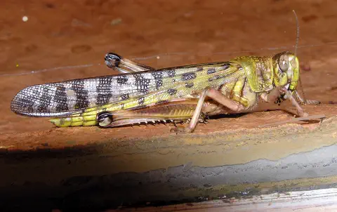
The desert locust is a large grasshopper of the deserts of Africa, the Middle East and Southwest Asia. Most of the time it lives alone. But after good rains, when locusts become crowded, they change their color and behavior and can gather into enormous swarms that fly long distances and eat farmers' crops.
Explore next
-
Watch
Natural wonder
Nile
The Nile flows north through northeastern Africa to the Mediterranean Sea, and its basin is shared by 11 countries. Its length is usually given as about 6,650 kilometers. Two great branches, the White Nile and the Blue Nile, meet at Khartoum in Sudan, and the green strip of farmland along its banks made it the lifeline of ancient Egypt.
-
Watch
Natural wonder
Sahara
The Sahara fills almost all of northern Africa. Britannica calls it the largest hot desert in the world: about 4,800 kilometers from east to west and about 8.6 million square kilometers in all. Only about a quarter of it is sand dunes; the rest is gravel plains, rocky plateaus and mountains.
-
Watch
Animal
Dugong
The dugong is a large, slow marine mammal that grazes on seagrass meadows in warm, shallow coastal seas from East Africa to the western Pacific. It is a relative of the manatee and, surprisingly, more closely related to elephants than to cows. It has a whale-like tail, a big bristly snout and very good hearing.
-
Watch
Animal
Desert locust
The desert locust is a large grasshopper of the deserts of Africa, the Middle East and Southwest Asia. Most of the time it lives alone. But after good rains, when locusts become crowded, they change their color and behavior and can gather into enormous swarms that fly long distances and eat farmers' crops.
-
 Watch
 Country
Democratic Republic of the Congo
The Democratic Republic of the Congo, or DR Congo, is the second-largest country in Africa. The mighty Congo River curves through its rainforests, volcanoes rise in the east, and its capital, Kinshasa, is a center of music, fashion and popular culture.
-
 Watch
 Country
Ethiopia
Ethiopia is a country on the Horn of Africa with no coast. Much of it is high, rugged land cut by the Great Rift Valley, it is one of the world's oldest countries, and more than 110 million people live there.
-
 Watch
 Country
Kenya
Kenya is a country in East Africa, crossed by the equator. It has the snow-capped Mount Kenya, the deep Great Rift Valley, Lake Victoria and a long Indian Ocean coast, and about 54 million people live there, many of them speaking Swahili.
-
 Watch
 Country
Tanzania
Tanzania is a country in East Africa, just south of the Equator, on the Indian Ocean. It has Mount Kilimanjaro, Africa's highest mountain, deep lakes in the East African Rift, and the Serengeti, where huge herds of wildebeest travel each year.
For parents & teachers
What children will learn
- Locate Sudan and trace the White Nile and Blue Nile to their meeting at Khartoum.
- Explain how rainfall changes from north to south and how vegetation follows it.
- Describe the kingdom of Kush and its pyramids, temples and palaces.
- Name some of Sudan's peoples and languages without treating them as one culture.
Recommended ages: 3 to 17 · About 15 minutes
Talk about it
- Why might ancient kingdoms grow up along big rivers like the Nile?
- How could two rivers that meet look different from each other?
- Sudan has many languages. How many languages can people in your town speak?
Try at home or in class
- Pour a cup of muddy water and a cup of clear water into a tray from two sides and watch how the two streams meet and mix, like the Blue and White Niles.
- Build a small pyramid from sugar cubes or building blocks and compare a steep, narrow shape with a wide, low one.
Key vocabulary: confluence, savanna, atoll, pyramid, nomad, irrigation
Where these facts come from
- Wikidata , Wikimedia Foundation (CC0 1.0)
- Natural Earth vector data , Natural Earth (NACIS) (Public domain)
- UNESCO World Heritage List , UNESCO World Heritage Centre (Linked as a reference; site facts come from Wikidata)
- Sudan , Encyclopaedia Britannica
- Sudan: Plant and animal life (with people, languages) , Encyclopaedia Britannica
- Sudan: Religion (with settlement patterns and demographic trends) , Encyclopaedia Britannica
- Sudan: Agriculture, forestry, and fishing , Encyclopaedia Britannica
- Sudan: The kingdom of Kush , Encyclopaedia Britannica
- Sudan: The spread of Islam , Encyclopaedia Britannica
- Sudan: The growth of national consciousness , Encyclopaedia Britannica
- Sudan: Challenge to Bashir's rule and the 2019 military coup , Encyclopaedia Britannica
- Population, total: Sudan , World Bank Open Data
- Gebel Barkal and the Sites of the Napatan Region , UNESCO World Heritage Centre
- Archaeological Sites of the Island of Meroe , UNESCO World Heritage Centre
- Sanganeb Marine National Park and Dungonab Bay – Mukkawar Island Marine National Park , UNESCO World Heritage Centre
- PlayOwl region table, version 1 , PlayOwl (PlayOwl original data)
- flag-icons 7.5.0 , Panayiotis Lipiridis and contributors (MIT)
- Wikimedia Commons , Wikimedia Foundation (Per file (public domain, CC0, CC BY or CC BY-SA); see each media record)
Checked, not yet human-reviewed. Last updated October 24, 2026. Spotted a mistake? Tell us.