
Natural wonder Africa
Lake Albert
Lake Albert is a long lake in Africa. It lies in a long valley between steep walls. A river called the Albert Nile flows out of it.
Lake Albert lies in the Albertine Rift, a branch of the East African Rift, shared by Uganda and the Democratic Republic of the Congo. It is about 150 kilometers long, and the Victoria Nile flows in at its north end, right beside the Albert Nile flowing out.
Lake Albert is a rift-valley lake (a tectonic graben) about 150 km long and 35 km wide on average, between escarpments in the Albertine Rift. The Semliki River feeds its south end from Lake Edward; the Victoria Nile enters at the far north, almost directly into the outflowing Albert Nile.
Photo: Albert Backer, CC BY-SA 3.0, via Wikimedia Commons
Discover Lake Albert
Lake Albert is a long lake in Africa. Its water flows out into a river, the Albert Nile.
In this photo, the lake's water meets the river. Palm trees and green swamp plants grow on the shore.
Lake Albert is shared by Uganda and the Democratic Republic of the Congo. The International Lake Environment Committee (ILEC) describes it as about 150 kilometers long, with its surface about 615 meters above sea level. Only one river flows out of it: the Albert Nile.
This photo by Albert Backer, taken on 15 January 2008, shows Lake Albert flowing out into the Albert Nile near Pakwach in Uganda, with palm trees and swamp plants on the bank.
ILEC's World Lake Database gives Lake Albert a length of about 150 km, an average width of about 35 km, a surface about 615 m above sea level and a single outflow, the Albert Nile; its table lists a maximum depth of 58 m and a mean depth of 25 m (its text gives 56 m, near the mid-western shore). Published areas differ (5,300 km² from ILEC; IAGLR lists 5,590 and 5,300 km²).
The hero photo, by Albert Backer (15 January 2008), is captioned 'Lake Albert flowing out into Albert Nile near Pakwach, Uganda': open water with floating plants, palms and swamp vegetation.
- Length
- about 150 km (average width about 35 km)
- Water surface
- about 615 m above sea level
- Outflow
- one river, the Albert Nile
- Countries
- Uganda and the Democratic Republic of the Congo
A lake in a rift
Lake Albert lies in a long, low valley. The land there is slowly pulling apart.
Steep walls of land rise on both sides of the lake.
Lake Albert lies in the Albertine Rift, a branch of the East African Rift. The European Space Agency (ESA) explains that along this rift, part of Africa is splitting away from the rest of the continent. When land pulls apart like this, a block can drop down between two lines of cracks, making a long valley called a graben.
ILEC describes Lake Albert as a typical rift-valley lake between two escarpments. On its western side, the land rises steeply to nearly 2,000 meters above the water.
The International Association for Great Lakes Research (IAGLR) lists the lake's geologic origin as tectonic (a graben). ESA describes the Albertine Rift as a branch of the East African Rift where the Somali Plate is splitting away from the rest of the continent.
ILEC calls Lake Albert a typical Rift Valley lake lying between two parallel escarpments, the western one rising abruptly to nearly 2,000 m above the water. Its account adds an 'accident of geological history': uptilting of the Lake Victoria basin in the late Pleistocene sent the Victoria Nile along an older valley to a low point in the rift wall, over Murchison Falls and into the lake's northern tip.
Rivers in and out
Two main rivers flow into Lake Albert. One river flows out.
The river that flows in at the top passes a powerful waterfall first.
The Semliki River brings water into the south end of the lake from Lake Edward. Rapids on the Semliki keep the fish of the two lakes apart.
At the north end, the Victoria Nile arrives after roaring through Murchison Falls, where the Uganda Wildlife Authority says it squeezes through a gorge about 8 meters wide and plunges 45 meters. It enters the lake almost beside the Albert Nile, which flows out, so its water mostly helps keep the lake's level steady.
ILEC describes the Semliki River as the main inflow at the south end, coming from Lake Edward past the edge of the Ituri forest, with kilometers of rapids that act as a barrier to fish moving between the two lakes. Most streams from the escarpments are seasonal and add little.
The Victoria Nile (which the Uganda Wildlife Authority says is forced through an 8-meter-wide gorge at Murchison Falls before a 45 m plunge) enters the northern tip almost directly into the outflowing Albert Nile. Because its water is much less saline than the lake's, conductivity measurements showed that even in floods it does not affect the lake beyond about 10 km from the north end; it mainly helps maintain the lake level.
Fish, hippos and shoebills
Many kinds of fish swim in Lake Albert.
Near the river mouth, people can spot hippos, crocodiles and a bird called the shoebill.
ILEC lists many fish in Lake Albert, including the Nile perch and tilapias, and marks several of them as important for fishing. The lake also gives people water.
In Murchison Falls National Park, along the Victoria Nile, the Uganda Wildlife Authority says hippos and Nile crocodiles are common along the riverbanks near the Albert Delta. The shoebill, a much-sought-after bird, is commonly spotted there too.
ILEC's fish list includes Alestes baremose, Lates niloticus (Nile perch), Hydrocynus, Clarias, Mormyrus, Polypterus, tilapias, Citharinus and Distichodus niloticus, and marks several as economically important; its uses for the lake are water supply and fisheries. The lake is monomictic: it stratifies in March and mixes in August.
Murchison Falls National Park, at the northern end of the Albertine Rift, was gazetted as a game reserve in 1926 and as a national park in 1952. The Uganda Wildlife Authority records over 556 bird species there and says the shoebill is commonly spotted along the Albert Delta, where hippos and Nile crocodiles are common on the riverbanks.
Visiting safely
Lake Albert is home to hippos and crocodiles.
Near water, always stay close to your grown-up and wear a life jacket.
The Uganda Wildlife Authority says hippos and Nile crocodiles are common along the riverbanks near the Albert Delta.
The US Centers for Disease Control and Prevention (CDC) says life jackets lower the risk of drowning while boating, and that children should wear them for all activities in and around natural water. Grown-ups should watch children closely near water.
Near the Albert Delta, the Uganda Wildlife Authority describes hippos and Nile crocodiles as common along the riverbanks, and says elephants, giraffes and buffaloes come to the banks of the river below Murchison Falls.
The CDC advises that life jackets reduce the risk of drowning while boating for people of all ages and swimming abilities, that children should use them for all activities in and around natural water, and that air-filled or foam toys are not safety devices. Adults should supervise children closely, even when lifeguards are present.
Amazing facts
-
At Murchison Falls, the river squeezes through a gap only about 8 meters wide.
At Murchison Falls, the Victoria Nile is forced through a gorge about 8 meters wide and plunges 45 meters before flowing on to Lake Albert.
The Uganda Wildlife Authority describes the Victoria Nile forced through an 8-meter-wide gorge at Murchison Falls, plunging 45 m, at the end of an 80 km stretch of rapids.
-
Rapids on one river keep the fish of two lakes apart.
Rapids on the Semliki River stop fish from moving between Lake Edward and Lake Albert.
ILEC notes that several kilometers of rapids on the Semliki are an effective barrier to faunal interchange between Lakes Edward and Albert.
-
The river water and the lake water are not quite the same.
The Victoria Nile is much less salty than Lake Albert, so scientists could trace where its water goes. It only reaches about 10 kilometers into the lake.
Conductivity measurements showed that the less saline Victoria Nile water does not affect Lake Albert beyond about 10 km from the north end, even in floods.
Words to know
- rift
- a long crack or valley where the land is slowly pulling apart
- graben
- a block of land that has dropped down between two faults, making a long valley
- escarpment
- a long, steep slope or cliff at the edge of higher land
- delta
- low, often swampy land where a river spreads out as it reaches a lake or the sea
- outflow
- a river that carries water out of a lake
Discovery challenge
-
Which river flows out of Lake Albert?
Which river is Lake Albert's one outflow?
Which river does ILEC list as Lake Albert's single outflow?
- The Albert Nile
- The Amazon
- The Danube
Show the answer
The Albert Nile
The Albert Nile.
The Albert Nile, at the lake's north end.
The Albert Nile, leaving the northern tip next to where the Victoria Nile enters.
-
Which river brings water into the south end of the lake?
Which river flows into Lake Albert's south end from Lake Edward?
Which river is the main inflow at the lake's south end, coming from Lake Edward?
- The Semliki River
- The Thames
- The Mekong
Show the answer
The Semliki River
The Semliki River.
The Semliki River, which comes from Lake Edward.
The Semliki, whose rapids also keep the two lakes' fish apart.
-
What kind of valley is Lake Albert in?
What kind of valley holds Lake Albert?
What type of valley does IAGLR give as Lake Albert's geologic origin?
- A rift valley, where the land pulls apart
- A valley dug by a glacier
- The crater of a volcano
Show the answer
A rift valley, where the land pulls apart
A rift valley, where the land is pulling apart.
A rift valley: the Albertine Rift, a branch of the East African Rift.
Tectonic: a graben in the Albertine Rift.
-
Which bird can people spot near the lake?
Which sought-after bird is commonly spotted along the Albert Delta?
Which bird does the Uganda Wildlife Authority say is commonly spotted along the Albert Delta?
- The shoebill
- The penguin
- The puffin
Show the answer
The shoebill
The shoebill!
The shoebill, one of Africa's most sought-after birds.
The shoebill, in Murchison Falls National Park.
-
What should children wear on a boat?
What does the CDC say children should wear for all activities in and around natural water?
According to the CDC, what reduces the risk of drowning while boating for people of all ages?
- A life jacket
- A foam toy
- A sun hat
Show the answer
A life jacket
A life jacket.
A life jacket. Foam toys are not safety devices.
A life jacket; air-filled or foam toys are not safety devices.
Nearby places
-
 Watch
Landmark
Kasubi Tombs
The Kasubi Tombs stand on Kasubi hill in Kampala, Uganda. The main building, a huge round house with a domed roof of thatch, was built in 1882 as a palace for the Kabaka, the king of Buganda, and became the burial place of four kings. After a fire in 2010 it was rebuilt, and the work was finished in 2023.
-
 Watch
City
Kampala
Kampala is the capital of Uganda, near the shores of Lake Victoria. It grew from the royal capital of the Buganda kingdom, built on hills separated by marshy valleys. Uganda's 2024 census counted 1,797,722 people in Kampala City, by far the largest city in the country.
-
 Watch
Natural wonder
Virunga National Park
Virunga National Park, in the east of the Democratic Republic of the Congo, was founded in 1925; the park describes itself as Africa's first national park. It stretches from active volcanoes in the south to the snowy Rwenzori Mountains in the north. About one third of the world's mountain gorillas live in its forests, along with elephants, hippos, chimpanzees and hundreds of kinds of birds.
-
 Watch
Natural wonder
Lake Victoria
Lake Victoria is the largest lake in Africa, and Britannica says only Lake Superior, in North America, is a bigger freshwater lake. It is shared by Kenya, Tanzania and Uganda. The lake is wide but shallow, its only outlet is the Nile, and it is home to hundreds of kinds of colorful fish called cichlids.
-
 Watch
Natural wonder
Mount Nyiragongo
Mount Nyiragongo is a steep volcano in the Virunga Mountains of the Democratic Republic of the Congo, near the border with Rwanda and just north of Lake Kivu. It is 3,470 meters high, and its deep summit crater often holds a lake of bubbling lava. Its lava is very runny, and eruptions in 1977, 2002 and 2021 sent lava flowing down its sides toward the city of Goma.
-
 Watch
City
Kigali
Kigali is the capital of Rwanda, a country of many hills in the middle of Africa. Rwanda's 2022 census counted 1,745,555 people in the City of Kigali. When Rwanda became independent in 1962, Kigali was a small town of about 6,000 people.
-
 Watch
City
Mwanza
Mwanza is a city in Tanzania on the shore of Lake Victoria. Larousse calls it a commercial center linked by ship to Kenya and Uganda and by railway to Dar es Salaam. Tanzania's 2022 census counted 1,104,521 people in the city, the country's second-largest after Dar es Salaam.
-
 Watch
Natural wonder
Great Rift Valley
The Great Rift Valley is a huge valley that runs through East Africa, where the continent is slowly being stretched and pulled apart. Long, steep cliffs line its sides, its floor holds lakes full of flamingos, and giant volcanoes such as Kilimanjaro and Mount Kenya rose beside it. Scientists think a new ocean may one day open here.
Explore next
-
 Watch
Natural wonder
Nile
The Nile flows north through northeastern Africa to the Mediterranean Sea, and its basin is shared by 11 countries. Its length is usually given as about 6,650 kilometers. Two great branches, the White Nile and the Blue Nile, meet at Khartoum in Sudan, and the green strip of farmland along its banks made it the lifeline of ancient Egypt.
-
Watch
Natural wonder
Lake Victoria
Lake Victoria is the largest lake in Africa, and Britannica says only Lake Superior, in North America, is a bigger freshwater lake. It is shared by Kenya, Tanzania and Uganda. The lake is wide but shallow, its only outlet is the Nile, and it is home to hundreds of kinds of colorful fish called cichlids.
-
Watch
Natural wonder
Great Rift Valley
The Great Rift Valley is a huge valley that runs through East Africa, where the continent is slowly being stretched and pulled apart. Long, steep cliffs line its sides, its floor holds lakes full of flamingos, and giant volcanoes such as Kilimanjaro and Mount Kenya rose beside it. Scientists think a new ocean may one day open here.
-
Watch
 Country
Uganda
Uganda is a landlocked country in East Africa, on the shores of Lake Victoria, Africa's largest freshwater lake. The Victoria Nile flows out of the lake here, snowy mountains rise in the west, and its forests are home to mountain gorillas and chimpanzees. About 51.4 million people lived there in 2025.
-
Watch
 Country
Democratic Republic of the Congo
The Democratic Republic of the Congo, or DR Congo, is the second-largest country in Africa. The mighty Congo River curves through its rainforests, volcanoes rise in the east, and its capital, Kinshasa, is a center of music, fashion and popular culture.
-
 Watch
Animal
Shoebill
The shoebill is a tall gray bird of African swamps, named for its enormous bill shaped like a wooden shoe. It stands as still as a statue among the papyrus, then lunges forward to grab big, slippery fish such as lungfish.
-
 Watch
Natural wonder
Victoria Falls
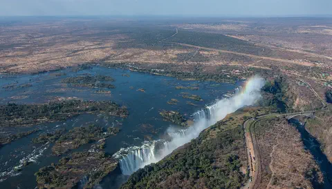
Victoria Falls, on the Zambezi River between Zambia and Zimbabwe, is about 1,708 meters wide and up to 108 meters deep. UNESCO calls it the largest curtain of falling water in the world, and its spray can be seen from tens of kilometers away.
-
 Watch
Natural wonder
Sahara
The Sahara fills almost all of northern Africa. Britannica calls it the largest hot desert in the world: about 4,800 kilometers from east to west and about 8.6 million square kilometers in all. Only about a quarter of it is sand dunes; the rest is gravel plains, rocky plateaus and mountains.
For parents & teachers
What children will learn
- Locate Lake Albert in the Albertine Rift, in Uganda and the Democratic Republic of the Congo.
- Explain how a rift valley forms a long, narrow lake.
- Name the rivers that flow into and out of the lake.
- Describe how to stay safe near lakes and rivers.
Recommended ages: 3 to 17 · About 15 minutes
Talk about it
- Why might a lake in a rift valley be long and narrow?
- How could scientists tell river water from lake water by measuring it?
- Why might rapids keep the fish of two lakes apart?
Try at home or in class
- Fill a long baking dish with water, add a few drops of food coloring at one end and pour clear water in slowly beside it: watch how far the color spreads, like the Victoria Nile entering the lake.
- Put two books side by side, then slide them apart and let a third book drop into the gap: that is how a graben forms.
Key vocabulary: rift, graben, escarpment, delta, outflow
Where these facts come from
- Wikidata , Wikimedia Foundation (CC0 1.0)
- Lake Albert (World Lake Database, AFR-11) , International Lake Environment Committee Foundation
- Lake Albert , International Association for Great Lakes Research
- Lakes and mountains of western Uganda , European Space Agency
- Murchison Falls National Park , Uganda Wildlife Authority
- Preventing Drowning , US Centers for Disease Control and Prevention
- File:Albertsee-Albertnil.jpg , Wikimedia Commons
- Natural Earth vector data , Natural Earth (NACIS) (Public domain)
- Wikimedia Commons , Wikimedia Foundation (Per file (public domain, CC0, CC BY or CC BY-SA); see each media record)
Checked, not yet human-reviewed. Last updated November 1, 2026. Spotted a mistake? Tell us.