Natural wonder Africa
Victoria Falls
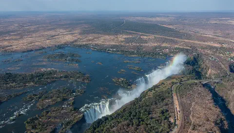
Victoria Falls is a giant waterfall in Africa. The Zambezi River tumbles over a cliff into a deep crack in the rock. Its spray rises up like smoke.
Victoria Falls, on the Zambezi River between Zambia and Zimbabwe, is about 1,708 meters wide and up to 108 meters deep. UNESCO calls it the largest curtain of falling water in the world, and its spray can be seen from tens of kilometers away.
Mosi-oa-Tunya / Victoria Falls is a transboundary World Heritage Site (1989) on the Zambezi between Zambia and Zimbabwe. The river drops up to 108 m along a 1,708 m front into a chasm cut in layered basalt, and seven earlier waterfall positions are preserved in the zigzag gorges below.
Photo: Diego Delso, CC BY-SA 4.0, via Wikimedia Commons
Discover Victoria Falls
Victoria Falls is a huge waterfall in Africa.
A wide river falls over a cliff. The water crashes down with a loud roar. White spray floats up into the sky, and rainbows shine in it.
Victoria Falls is on the Zambezi River, right on the border between Zambia and Zimbabwe in southern Africa. Here the river is more than 2 kilometers wide. Suddenly it falls over the edge of a long cliff into a deep, narrow crack in the rock.
The falls are about 1,708 meters wide and drop about 100 meters on average, 108 meters at the deepest point. UNESCO calls them the largest curtain of falling water in the world. The local name, Mosi-oa-Tunya, means the smoke that thunders, because of the towering clouds of spray and the roar of the water.
The falls lie at about 915 m above sea level on the Zambezi, which is more than 2 km wide just upstream. UNESCO gives the front as about 1,708 m wide, with an average depth of 100 m and a deepest point of 108 m; at peak flow up to 500 million liters a minute pour over, dropping 61 m at the Devil's Cataract, 83 m at the Main Falls, 99 m at Rainbow Falls and 98 m at the Eastern Cataract.
The property, inscribed in 1989, covers 6,860 ha across Mosi-oa-Tunya National Park in Zambia and Victoria Falls and Zambezi National Parks in Zimbabwe, and the falls can be viewed face-on from both countries. National Geographic translates the local name Mosi-oa-Tunya as the smoke that thunders. David Livingstone, the first European to see and document the falls, named them after Queen Victoria in 1855.
- Width
- about 1,708 m
- Drop
- about 100 m on average, 108 m at the deepest
- Water at its peak
- up to 500 million liters a minute
- World Heritage Site
- 1989 (Zambia and Zimbabwe)
How the falls were made
Long, long ago, hot melted rock flowed out and cooled into hard, dark rock.
The rock has long cracks in it. The river wore one crack deep and wide, and now it falls into it. Bit by bit, the falls move back up the river.
The rock at Victoria Falls is basalt, a hard, dark rock made from ancient lava flows. Long cracks called joints run through it. Just above the falls, the Zambezi bends to flow south, and the whole river plunges into a deep, narrow slot worn out along one of these cracks. That slot is the chasm the falls drop into today.
Below the falls, the river zigzags through a series of steep gorges, turning from one crack to the next. UNESCO says seven earlier waterfalls once stood in seven of them. The falling water slowly wears away the bottom of the cliff until the rock above gives way, so the falls creep upstream. The Devil's Cataract, on the Zimbabwe side, is where the next cut has begun.
The falls cross banded basalt from ancient lava flows, with Kalahari sandstones and chalcedony; UNESCO notes that, unlike the vertical columns of the Giant's Causeway, these basalts are layered. Geologists writing in GEO ExPro identify the rock as the Batoka Basalt, part of the Karoo large igneous province of about 180 million years ago, creased by families of roughly east-west joints. Just upstream the Zambezi bends south and plunges 108 m into a chasm less than 120 m wide, carved along one of those joints.
IUCN's 1989 evaluation for UNESCO says that since the uplift of the Makgadikgadi Pan area some two million years ago, the Zambezi has been cutting through the basalt, exploiting weak fissures and forming a series of retreating gorges. The plunging water undercuts the base of the falls until the cliff collapses, so the falls migrate upstream. UNESCO calls the gorges an outstanding example of river capture: eight steep-sided gorges zigzag for about 150 km, seven previous waterfalls occupied the seven gorges below the present falls, and the Devil's Cataract is the starting point for cutting back to a new waterfall.
A rainforest made by spray
The spray from the falls is like rain that never stops.
So a small green forest grows right next to the falls. Monkeys, birds and warthogs live there. Special birds build nests in the steep gorges.
The cloud of spray from the falls can rise about 500 meters high. It drifts down like rain on the land beside the waterfall, keeping it wet all year. Because of this, a narrow strip of rainforest grows there, full of vines and trees.
Visitors on the Zimbabwe side may see warthogs, vervet monkeys, baboons and birds such as the bright Livingstone's turaco and the trumpeter hornbill. The flame lily, Zimbabwe's national flower, grows here too. The steep gorges below the falls are nesting places for endangered birds, including the Taita falcon and the black eagle.
UNESCO describes a riverine rainforest within the splash zone: a fragile, discontinuous forest on sandy alluvium that depends on abundant water and the high humidity of a spray plume up to about 500 m tall.
The eight gorges and the islands in the core zone are breeding sites for four endangered and migratory bird species, among them the Taita falcon and the black eagle, and the property is an Important Bird Area. National Geographic notes that a fence keeps most large animals out of the main viewing area in Zimbabwe, but warthogs, vervet monkeys, baboons, Livingstone's turaco and trumpeter hornbills are often seen, with vines, mahogany trees and the flame lily along the path. UNESCO also records stone tools from early humans and hunter-gatherers in the area.
High water and low water
Some months, the river is full and the falls roar.
Other months, there is less water. Then you can see the dark rock wall. Rainbows shine in the spray on sunny days.
How the falls look depends on the season. From March to May the Zambezi is at its fullest, after the summer rains, and the spray can be so thick it is hard to see the falls at all. From September to November, the hot, dry season, there is much less water, and you can see the rock walls of the gorge.
Rainbows often appear in the spray, especially in the middle of the morning and the middle of the afternoon. On some nights near the full moon, visitors can even see a moonbow, a rainbow made by moonlight.
National Geographic describes the cycle: the falls are at their high-water peak in the southern autumn (March to May), still flowing strongly but with less spray in winter (June to August), at their lowest in the hot, dry spring (September to November), when the geology of the gorge is easiest to see, and refilling with the summer rains from December.
UNESCO says the spray can be seen 30 km away from the Lusaka road in Zambia and 50 km away from the Bulawayo road in Zimbabwe. Rainbows are common in mid-morning and mid-afternoon, and around the full moon the Zimbabwe park reopens in the evening for lunar rainbows, which form when moonlight is refracted through the spray, depending on the weather and the spray.
Visiting safely
The paths near the falls are wet and slippery.
Hold a grown-up's hand and walk slowly. Stay well back from the edge of the cliff. Wear a raincoat, because the spray will make you wet! The little forest by the falls is delicate, and people work to look after it.
Visitors can see the falls from both Zambia and Zimbabwe. On the Zimbabwe side, a single footpath paved with small stones links 16 viewpoints. Expect to get wet: wear clothes that dry quickly and shoes with good grip, and bring or rent a raincoat.
Zimbabwe's park authority gives two cautions: avoid the edge of the cliff, and watch out for slippery rocks. Some viewpoints have only simple barriers or no railings, so children need a grown-up close by. The rainforest beside the falls is fragile, and UNESCO says tourism and building around the falls must be carefully managed to protect the site. The town of Livingstone in Zambia and the town of Victoria Falls in Zimbabwe both lie close to the falls.
The falls are viewed from Zambia's Mosi-oa-Tunya National Park and Zimbabwe's Victoria Falls National Park; on the Zimbabwe side a stone-paved path about 2.5 miles long links 16 viewpoints. The Zimbabwe Parks and Wildlife Management Authority's cautions for the park are to avoid the edge of the cliff and beware of slippery rocks, and it suggests walking shoes and a first aid kit. National Geographic warns that slippery pathways and a lack of railings or only rudimentary barriers mean extra care with children, recommends quick-drying clothes, grippy shoes and a raincoat, and notes the often-slippery Chain Walk at Viewpoint 2, with 73 steps.
UNESCO notes that the falls' popularity brings urban infrastructure and tourism facilities that may affect the property's integrity and must be carefully managed. The two countries approved a Joint Integrated Management Plan in November 2007, dividing the site into high, medium and low ecologically sensitive zones, each with its own prescriptions, inside a buffer zone. UNESCO adds that the riverine rainforest depends on abundant water and the humidity of the spray.

Amazing facts
-
The falls have moved! They used to be farther down the river.
Seven earlier waterfalls once stood in the gorges below today's Victoria Falls.
UNESCO says seven previous waterfalls occupied the seven gorges below the present falls, which zigzag for about 150 km.
-
You can sometimes see a rainbow at night here.
On some nights near the full moon, moonlight shining through the spray makes a moonbow.
Around the full moon, the Zimbabwe park reopens in the evening for lunar rainbows, depending on the weather and the spray.
-
The spray goes up very, very high.
The cloud of spray above Victoria Falls can rise about 500 meters into the air.
UNESCO gives the spray plume a maximum height of about 500 m, visible 50 km away from the Bulawayo road and 30 km from the Lusaka road.
-
A little forest grows because of the waterfall's spray.
The rainforest beside the falls lives on the spray, which falls on it like rain all year.
UNESCO describes the splash-zone forest as fragile and dependent on abundant water and the humidity of the spray plume.
Words to know
- waterfall
- a place where a river or stream drops over a steep edge
- gorge
- a deep, narrow valley with steep rocky sides
- basalt
- a hard, dark rock made when lava cools
- spray
- tiny drops of water flung into the air
- erosion
- the slow wearing away of rock by water, wind or ice
- moonbow
- a rainbow made by moonlight instead of sunlight
Discovery challenge
-
Which river makes Victoria Falls?
Which river pours over Victoria Falls?
Which river forms Victoria Falls on the Zambia–Zimbabwe border?
- The Nile
- The Zambezi
- The Amazon
Show the answer
The Zambezi
The Zambezi River makes Victoria Falls.
The Zambezi, more than 2 kilometers wide here, falls into a chasm in the rock.
The Zambezi, over 2 km wide at this point, plunges into a chasm cut in layered basalt.
-
What does the name Mosi-oa-Tunya mean?
The local name Mosi-oa-Tunya means what?
How does National Geographic translate the name Mosi-oa-Tunya?
- The smoke that thunders
- The quiet river
- The golden rock
Show the answer
The smoke that thunders
It means the smoke that thunders.
It means the smoke that thunders, for the towering spray and the roar.
The smoke that thunders, describing the mist plumes and the sound of the falls.
-
What kind of rock is under the falls?
What kind of rock has the Zambezi cut into at Victoria Falls?
The falls and their gorges are cut into which igneous rock?
- Basalt, made from lava
- Chalk, made from shells
- Ice, made from snow
Show the answer
Basalt, made from lava
It is basalt, a hard rock made from lava.
The rock is basalt from ancient lava flows, cooled in layers.
Banded, layered basalt from ancient lava flows, unlike the columnar basalt of the Giant's Causeway.
-
What grows next to the falls because of the spray?
What grows beside the falls because the spray keeps the land wet?
Which ecosystem depends on the falls' spray plume?
- A cactus desert
- A strip of rainforest
- A pine forest in the snow
Show the answer
A strip of rainforest
A little green rainforest grows there.
The spray falls like rain, so a narrow rainforest grows beside the falls.
A fragile riverine rainforest in the splash zone, dependent on the plume's moisture and humidity.
-
What is the best way to walk near the falls?
How should visitors walk on the paths near the falls?
Which precaution does National Geographic stress for families at Victoria Falls?
- Run fast to the edge
- Walk slowly, because the paths are wet and slippery
- Climb onto the rocks for a better look
Show the answer
Walk slowly, because the paths are wet and slippery
Walk slowly and hold a grown-up's hand. The paths are wet.
The spray makes the paths slippery, and some viewpoints have no railings.
Slippery pathways and missing or rudimentary barriers mean extra care with children.
Nearby places
-
 Watch
Natural wonder
Okavango Delta
The Okavango Delta, in northwestern Botswana, is a huge wetland in the middle of a dry land. The Okavango River flows in from Angola, spreads out into channels, lagoons and grassy plains, and then soaks away into the sands of the Kalahari instead of reaching the sea. Its flood arrives in the dry season, drawing elephants, buffalo, zebras and many other animals.
-
 Watch
Natural wonder
Kalahari Desert
The Kalahari is a giant sandy plain in southern Africa, covering almost all of Botswana and parts of Namibia and South Africa. It stretches about 1,600 kilometers from north to south. Its southwest is a true desert, with long red dunes, while its north is green with woodlands and even has a huge swamp, the Okavango Delta.
-
 Watch
Natural wonder
Namib
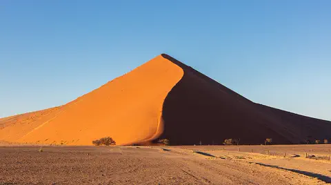
The Namib is a cool desert that runs for about 1,900 kilometers along Africa's Atlantic coast, from Angola through Namibia into South Africa. It gets almost no rain, but cold ocean water makes thick fog that drifts inland. UNESCO says its Namib Sand Sea is the only coastal desert in the world with huge dune fields influenced by fog.
-
 Watch
Natural wonder
Lake Tanganyika
Lake Tanganyika lies in a deep crack in Africa called a rift valley. Britannica calls it the longest freshwater lake in the world, and only Lake Baikal, in Russia, is deeper. Four countries share it: Tanzania, the Democratic Republic of the Congo, Burundi and Zambia. Its water is home to about 250 kinds of cichlid fish found nowhere else.
-
 Watch
Natural wonder
Mount Nyiragongo
Mount Nyiragongo is a steep volcano in the Virunga Mountains of the Democratic Republic of the Congo, near the border with Rwanda and just north of Lake Kivu. It is 3,470 meters high, and its deep summit crater often holds a lake of bubbling lava. Its lava is very runny, and eruptions in 1977, 2002 and 2021 sent lava flowing down its sides toward the city of Goma.
-
 Watch
Natural wonder
Ngorongoro Conservation Area
The Ngorongoro Conservation Area in northern Tanzania holds the Ngorongoro Crater, a giant bowl about 16 to 20 kilometers across, left when an ancient volcano collapsed about 2.5 million years ago. Around 25,000 large animals live in and around the crater. The area also protects Olduvai Gorge and Laetoli, where scientists have found important evidence of how humans evolved.
-
 Watch
Natural wonder
River Congo
The Congo is Africa's second-longest river, about 4,700 kilometers long. It curves in a giant arc through the rainforests of central Africa and empties into the Atlantic Ocean. Rain falls in its basin all year, so it carries a huge amount of water, and its wild lower rapids are home to about 320 kinds of fish, about 90 of them found nowhere else.
-
 Watch
Natural wonder
Serengeti National Park
Serengeti National Park in northern Tanzania protects 14,763 square kilometers of grassy plains and woodlands. Each year more than a million wildebeest, with zebras and gazelles, travel a great loop across the Serengeti and into Kenya in search of grass and water, followed by lions and other predators.
Experiments to try
Explore next
-
Watch
 Country
Zambia
Zambia is a landlocked country on a high plateau in south-central Africa, named after the Zambezi River. On its southern border the Zambezi thunders over Victoria Falls. About 22 million people live there, and its copper mines have long made it one of Africa's great copper producers.
-
 Watch
 Country
Zimbabwe
Zimbabwe is a landlocked country in southern Africa, high on a wide plateau between the Zambezi and Limpopo rivers. It shares Victoria Falls with Zambia, and its name is a Shona word meaning "stone houses", the name of the great stone city of Great Zimbabwe.
-
 Watch
Natural wonder
Iguaçu Falls
Iguaçu Falls, on the Iguaçu River where Brazil and Argentina meet, is a system of many waterfalls and rapids almost three kilometers wide, with drops of up to about 80 meters. Clouds of spray keep the rainforest around it green and wet.
-
 Watch
Natural wonder
Niagara Falls
Niagara Falls is a set of three waterfalls on the Niagara River, which flows from Lake Erie to Lake Ontario across the border between Canada and the United States. About 500 waterfalls in the world are taller, but Niagara is famous for its height together with the enormous amount of water that pours over it.
- Watch What If? Lab What if a river changed its course? A winding river wears away the outside of each bend and piles sand on the inside, so slowly, year by year, it moves. Sometimes it cuts off a loop and leaves a lake behind. Imagine a big river changing its course: what would happen to the old loops, and to the towns and bridges beside it?
-
 Watch
Natural wonder
Sahara
The Sahara fills almost all of northern Africa. Britannica calls it the largest hot desert in the world: about 4,800 kilometers from east to west and about 8.6 million square kilometers in all. Only about a quarter of it is sand dunes; the rest is gravel plains, rocky plateaus and mountains.
-
 Watch
Natural wonder
Mount Kilimanjaro
Mount Kilimanjaro, in northeastern Tanzania, is what UNESCO calls the highest mountain in Africa: its top is 5,895 meters high. It is a huge volcanic mountain standing alone above the plains, and as you climb it you pass through farms, forest, moorland and high alpine desert to its icy top.
-
Watch
Natural wonder
Serengeti National Park
Serengeti National Park in northern Tanzania protects 14,763 square kilometers of grassy plains and woodlands. Each year more than a million wildebeest, with zebras and gazelles, travel a great loop across the Serengeti and into Kenya in search of grass and water, followed by lions and other predators.
For parents & teachers
What children will learn
- Locate Victoria Falls on the Zambezi between Zambia and Zimbabwe.
- Explain how the river cut into weak lines in basalt and how the falls have moved upstream.
- Describe how the spray creates a small rainforest.
- Name ways visitors stay safe on wet paths and protect the fragile forest.
Recommended ages: 3 to 17 · About 15 minutes
Talk about it
- Why might a waterfall slowly move upstream over a very long time?
- How can a waterfall make its own little forest?
- Two countries share these falls. How might they work together to protect them?
Try at home or in class
- Spray water from a spray bottle in front of a flashlight or sunny window and look for a small rainbow.
- Pour water along a tray of packed sand with a groove cut across it; watch the water drop into the groove and carve it deeper.
Key vocabulary: waterfall, gorge, basalt, spray, erosion, moonbow
Where these facts come from
- Wikidata , Wikimedia Foundation (CC0 1.0)
- Natural Earth vector data , Natural Earth (NACIS) (Public domain)
- Mosi-oa-Tunya / Victoria Falls , UNESCO World Heritage Centre
- Everything you need to know about Victoria Falls National Park , National Geographic
- Victoria Falls National Park , Zimbabwe Parks and Wildlife Management Authority
- World Heritage nomination, IUCN summary: 509 Victoria Falls/Mosi-oa-Tunya (1989) , IUCN, via UNESCO World Heritage Centre
- Victoria Falls: The Smoke That Thunders (Lon Abbott and Terri Cook) , GEO ExPro
- Wikimedia Commons , Wikimedia Foundation (Per file (public domain, CC0, CC BY or CC BY-SA); see each media record)
Checked, not yet human-reviewed. Last updated October 24, 2026. Spotted a mistake? Tell us.