
 Country
Asia
Cambodia
Cambodia is a country in Southeast Asia with big rivers and a giant lake. Long ago, people there built Angkor Wat and other huge stone buildings.
Cambodia is a country in mainland Southeast Asia, a land of wide plains and great rivers. Its Tonle Sap lake more than doubles in size every rainy season, and Angkor, with the remains of capitals built from the 800s to the 1400s, is one of the most important archaeological sites in Southeast Asia.
Cambodia is a largely rural country of mainland Southeast Asia, centered on a low alluvial plain around the Tonle Sap and the Mekong. From the 9th to the 15th century it was the heart of the Khmer Empire, whose capitals survive at Angkor, and its population was about 17.28 million in 2024 by the national statistics institute's projections.
Photo: Luca Nebuloni, CC BY 2.0, via Wikimedia Commons
Discover Cambodia
Cambodia is a country in Southeast Asia.
It has wide, flat land and big rivers. There is a giant lake in the middle. The capital city is called Phnom Penh. Most people live in villages.
Cambodia is in mainland Southeast Asia, between Thailand, Laos and Vietnam, with a coast on the Gulf of Thailand. Most of the country is a low, flat plain around a huge lake, the Tonle Sap, and the great Mekong River, with hills and low mountains around the edges.
The capital is Phnom Penh, where three rivers meet. Cambodia covers about 181,000 square kilometers, and about 17.3 million people lived there in 2024. Most of them live in the countryside rather than in cities.
Cambodia lies in mainland Southeast Asia, amid important overland and river trade routes linking China to India and Southeast Asia (Britannica). It measures about 450 km from north to south and 580 km from east to west, and covers about 181,000 km². Its landscape is a low-lying central alluvial plain, containing the Tonle Sap and the upper reaches of the Mekong delta, ringed by transitional plains, uplands and low mountains.
The National Institute of Statistics projects a population of 17,280,543 for 2024. Some four-fifths of people live in rural areas; Phnom Penh, at the confluence of the Mekong, Bassac and Sab rivers, has been home to most town dwellers since the 1920s. Influences from many Asian cultures, and from France and the United States, can be seen in the capital.
Cities and famous places
Phnom Penh is the biggest city.
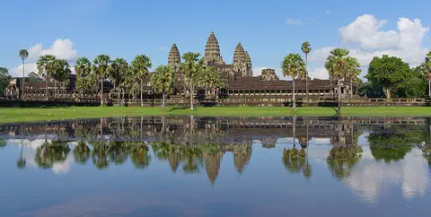
It is beside wide rivers. Near the town of Siem Reap is Angkor. It has huge old stone buildings. Angkor Wat has tall towers and a moat of water around it.
Phnom Penh, the capital, stands where the Mekong, Bassac and Sab rivers meet, and about 2.1 million people lived there in 2019. Battambang, in the northwest, and Siem Reap are other important towns.
Near Siem Reap is Angkor, one of the most important archaeological sites in Southeast Asia. Over about 400 square kilometers it holds the remains of the capitals of the Khmer Empire from the 800s to the 1400s, including Angkor Wat and the Bayon at Angkor Thom, covered in carvings. Villages and rice fields still lie inside the park.
Phnom Penh, thought to have been founded in the mid-15th century, when many Khmer were probably drawn south from Angkor, lies at the confluence of the Mekong, Bassac and Sab rivers; Wikidata gives about 2.13 million people in 2019. Battambang and Siem Reap lie in the northwest.
Angkor Archaeological Park, inscribed by UNESCO in 1992, stretches over some 400 km² including forest and contains the remains of the Khmer capitals from the 9th to the 15th century, among them Angkor Wat and, at Angkor Thom, the Bayon with its countless sculptural decorations; UNESCO also names Banteay Srei among the masterpieces of Khmer art. The park is inhabited, and its villagers grow rice. Two older capitals are also World Heritage Sites: Sambor Prei Kuk (2017), the remains of Ishanapura, capital of the Chenla Empire in the late 6th and early 7th centuries, and Koh Ker (2023), a Khmer capital from 921 to 944 CE built with colossal stone blocks.
A lake that grows and shrinks
The Mekong is a long, wide river.
In the rainy season, it fills up with water. The water flows into a big lake. The lake grows much, much bigger! In the dry season, it gets smaller again.
The Mekong River flows south through eastern Cambodia for about 510 kilometers. In the rainy season, from mid-May to early October, so much water comes down the Mekong that it pushes up the Sab River into the Tonle Sap lake. The lake grows from about 3,100 square kilometers to more than 7,800 square kilometers. In the dry season the river switches direction, and the water drains back out.
The highest mountain, Mount Aôral, is 1,813 meters tall, in the remote highlands of the southwest. The weather is hot: in April, daytime highs reach about 35 °C.
The Mekong enters Cambodia from Laos at the Khone Falls and flows about 510 km to the Vietnamese border. During the southwest monsoon (mid-May to early October) its volume backs up the Sab River for about 105 km into the Tonle Sap, expanding the lake from a dry-season minimum of about 3,100 km² to a rainy-season maximum of more than 7,800 km²; as the Mekong falls, the flow reverses. Britannica calls the Tonle Sap one of the world's richest sources of freshwater fish, and UNESCO, whose Tonle Sap Biosphere Reserve dates from 1997, ranks it among the top four fishery production areas in the world.
A sandstone escarpment marks the Dângrêk Mountains to the north, and in the southwest the Krâvanh (Cardamom) and Dâmrei (Elephant) Mountains rise to Mount Aôral, 1,813 m, the highest peak. Maximum temperatures run from about 28 °C in January to 35 °C in April. Rainfall ranges from more than 5,000 mm on the seaward slopes of the southwestern highlands to about 1,270-1,400 mm in the central lowlands, three-fourths of it during the southwest monsoon. The annual floods leave alluvial sediment that keeps the central plain fertile for rice.
Animals of Cambodia
A few elephants and tigers may still live in Cambodia's forests.
Bears and deer may live there too. Water birds such as cranes and herons are common. Lots and lots of fish swim in the big lake.
Forests cover much of Cambodia, from tall evergreen forests in the north to rainforests in the southwest and mangroves along the coast. Small numbers of elephants, wild oxen and several kinds of deer may still live in the northeastern forests, along with some tigers, leopards and bears.
Water birds such as herons, cranes, pelicans, cormorants and egrets are common. The Tonle Sap is full of fish, and the Siamese crocodile, now endangered, lives in the Tonle Sap area. Cambodia also has dangerous snakes, such as the king cobra.
Britannica describes evergreen forests with trees 30 m tall in the northern mountains, pine forests and rainforests over 45 m tall in the southwestern highlands, and mangroves on the coast. The northeastern forests once sheltered large populations of elephants, wild oxen, rhinoceroses and deer, but the loss of forest cover, warfare and unregulated hunting sharply reduced them; small populations of most of these species may remain, with some tigers, leopards and bears. Herons, cranes, pelicans, cormorants and egrets are among the more common birds, and the Indian cobra, king cobra, banded krait and Russell's viper are the most dangerous snakes.
The Tonle Sap Biosphere Reserve combines the lake, the flooded forests and swamps around it, and seasonally flooded rice fields and grasslands. UNESCO notes that overfishing is a key issue: eight fish sanctuaries protect endangered and vulnerable fish, and the Siamese crocodile (Crocodylus siamensis) has become endangered because of its high commercial value.

People, languages and food
About 17 million people lived in Cambodia in 2024.
Most people speak Khmer. Many meals have rice and fish. In April, people celebrate Khmer New Year. In November, there is a water festival.
Most people in Cambodia are Khmer, and nearly everyone speaks the Khmer language. Chinese, Vietnamese, Cham and Lao people live there too, along with Indigenous peoples of the northeastern highlands. Most Khmer people practice Theravada Buddhism, and the Cham are Muslim.
Many meals are based on rice and fish, flavored with hot peppers, mint, lemongrass, ginger and prahoc, a spiced fish paste. Ka tieu is a popular noodle soup. Khmer New Year comes in mid-April, and the Water Festival in early November marks the time when the Tonle Sap's flow turns around. In the countryside, houses have traditionally been built on wooden posts.
The Khmer, of the Mon-Khmer ethnolinguistic group, make up the vast majority of the population, concentrated in the lowlands around the Mekong and the Tonle Sap and along the coast. Minorities include Chinese, Vietnamese, Cham-Malays (Khmer Islam), Lao and the upland peoples known together as Khmer Loeu, such as the Jarai, Mnong and Stieng. Khmer, an Austroasiatic language, is spoken by nearly everyone. Most Khmer are Theravada Buddhists; Theravada Buddhism was restored as the state religion in 1993, and the Cham are mostly Sunni Muslim.
Cambodia remains a land of villages: some four-fifths of people are rural, and houses have generally been built on wooden pilings. Rice and fish are the base of many meals, with garnishes such as mint, lemongrass, ginger, prahoc and red curry paste. The Royal Ballet of Cambodia, or Khmer classical dance, has been associated with the Khmer court for over a thousand years; its graceful hand gestures take years of training, and UNESCO inscribed it in 2008. Bonn Om Touk, the Water and Moon Festival in early November, marks the annual flow reversal of the Tonle Sap.

From Angkor to today
People have lived in Cambodia for a very long time.
Long ago, kings ruled a big empire from Angkor. Workers built huge buildings from stone. Many of them still stand today.
For about 2,000 years, Cambodia's civilization took in ideas from India and China and passed them on to its neighbors. Early kingdoms called Funan and Chenla grew up from the 1st to the 8th century. In 802 a king named Jayavarman II founded a new kingdom, and the age of Angkor began.
The Khmer Empire was strongest in the 1100s, when Angkor Wat and the city of Angkor Thom were built. Later, Angkor was slowly left behind, and many Khmer people were probably drawn south toward Phnom Penh. Cambodia came under French rule as a protectorate in 1863 and became independent in 1953. In 1999 it joined ASEAN, a group of Southeast Asian countries.
Britannica traces 2,000 years in which Cambodian civilization absorbed influences from India and China and passed them on. The Funan and Chenla kingdoms (1st to 8th century) were followed by the Angkor period (9th to 15th century): Jayavarman II proclaimed his kingdom in 802, Yaśovarman I moved the capital to Angkor around 890, and under Suryavarman II (ruled 1113 to about 1150) Angkor Wat was built. The empire reached its peak in the 12th century, then contracted; Tai armies attacked Angkor in 1369, 1389 and 1431, and historians debate whether those attacks, religious change or environmental damage to the irrigation system explain its decline. France established a protectorate in 1863, and independence came in 1953.
The Vietnam conflict spread into Cambodia after 1970, and from April 1975 to early 1979 the Khmer Rouge, a communist movement, ruled the country as Democratic Kampuchea; Britannica describes the human costs as enormous. Vietnamese forces overthrew the regime in 1979, a 1991 peace agreement led to UN-supervised elections in 1993, and a special court in Phnom Penh, the Extraordinary Chambers in the Courts of Cambodia, later convicted former Khmer Rouge leaders of crimes against humanity (2014) and genocide (2018). Cambodia joined ASEAN in 1999.
Cambodia on the map
Find Cambodia on the globe.
It is in Asia, near the sea. Thailand, Laos and Vietnam are its neighbors. The Mekong River flows right through it.
Cambodia is in mainland Southeast Asia. Thailand is to the west and northwest, Laos to the northeast and Vietnam to the east and southeast. To the southwest is the Gulf of Thailand.
The country is about 450 kilometers from north to south and 580 kilometers from east to west, about one-third the size of France. The Mekong River crosses the east of the country from north to south, and the Tonle Sap lake lies in the middle.
Cambodia is bordered by Thailand to the west and northwest, Laos to the northeast, Vietnam to the east and southeast, and the Gulf of Thailand to the southwest. It extends about 450 km north to south and 580 km east to west; Britannica compares it to about one-third the size of France.
The central plain is enclosed by the Dângrêk escarpment to the north, the eastern highlands that continue into Laos and Vietnam, and the Cardamom and Elephant Mountains in the southwest, which separate the Tonle Sap basin from a narrow, wooded coastal strip. The Mekong enters from Laos at the Khone Falls and leaves for its delta in Vietnam.
- North to south
- about 450 km
- East to west
- about 580 km
- Mekong River in Cambodia
- about 510 km
- Highest peak
- Mount Aôral, 1,813 m
- People (2024 projection)
- 17,280,543
Amazing facts
-
A river in Cambodia changes direction every year.
In the rainy season the Sab River flows into the Tonle Sap lake, and in the dry season it flows back out the other way.
The Mekong's rising waters back up the Sab River into the Tonle Sap each rainy season; when the Mekong falls, the Sab's flow reverses.
-
Angkor covers a very big area.
Angkor Archaeological Park, with its forests, covers about 400 square kilometers.
Angkor Archaeological Park stretches over some 400 km², including forested areas, and is still inhabited by rice-growing villages.
-
There is a festival for the lake's water.
The Water Festival, Bonn Om Touk, in early November, marks the time when the Tonle Sap's flow turns around.
Bonn Om Touk, the Water and Moon Festival in early November, marks the annual flow reversal of the Tonle Sap.
-
Cambodian dancers use graceful hand movements.
Khmer classical dance, the Royal Ballet of Cambodia, is known for graceful hand gestures that take years to learn.
The Royal Ballet of Cambodia has been associated with the Khmer court for over a thousand years; UNESCO inscribed it in 2008 (proclaimed 2003).
Words to know
- monsoon
- a wind that changes direction with the seasons and brings a rainy season
- floodplain
- flat land beside a river that is covered with water when the river floods
- alluvial
- made of the mud and sand that rivers leave behind
- empire
- a group of lands or peoples ruled by one ruler or government
- archaeological site
- a place where people study the remains of the past
- moat
- a wide ditch filled with water around a building or city
- World Heritage Site
- a place UNESCO lists as important to all people, to be protected
Discovery challenge
-
What is the capital city of Cambodia?
Which city, where three rivers meet, is the capital of Cambodia?
Which city, at the confluence of the Mekong, Bassac and Sab rivers, is Cambodia's capital?
- Siem Reap
- Battambang
- Phnom Penh
Show the answer
Phnom Penh
Phnom Penh is the capital of Cambodia.
Phnom Penh is the capital. It stands where the Mekong, Bassac and Sab rivers meet.
Phnom Penh, thought to have been founded in the mid-15th century, has held most of Cambodia's town dwellers since the 1920s.
-
What happens to the big lake in the rainy season?
What happens to the Tonle Sap lake in the rainy season?
When the Mekong rises in the southwest monsoon, what happens to the Tonle Sap?
- It grows much bigger
- It freezes
- It dries up
Show the answer
It grows much bigger
Lots of river water flows in, and the lake grows much bigger.
The Mekong pushes water up into the lake, which grows from about 3,100 to more than 7,800 square kilometers.
The Mekong backs up the Sab River, expanding the lake to more than 7,800 km²; the flow reverses in the dry season.
-
What are the old buildings of Angkor made of?
The old buildings of Angkor are made of brick and what else?
UNESCO says all that remains of the Khmer Empire is its heritage of structures in brick and what other material?
- Ice
- Stone
- Glass
Show the answer
Stone
The buildings of Angkor are made of stone and brick.
UNESCO says the Khmer Empire left buildings of brick and stone, such as those at Angkor.
UNESCO notes that the Khmer Empire's remains are structures in brick and stone; Angkor Wat dates from the 12th century.
-
Which language do most people in Cambodia speak?
Which language is spoken by nearly everyone in Cambodia?
Which Mon-Khmer language of the Austroasiatic family is spoken by nearly all people in Cambodia?
- Khmer
- Spanish
- Japanese
Show the answer
Khmer
Most people in Cambodia speak Khmer.
Nearly everyone in Cambodia speaks Khmer, including many people from minority groups.
Khmer, of the Mon-Khmer subfamily of Austroasiatic, is spoken by nearly all Cambodians, including the Cham-Malay.
-
Which country is next to Cambodia?
Which country borders Cambodia to the east and southeast?
Which country borders Cambodia to the east and southeast, where the Mekong flows on to its delta?
- Vietnam
- Japan
- Australia
Show the answer
Vietnam
Vietnam is next to Cambodia. So are Thailand and Laos.
Vietnam is to the east and southeast, Thailand to the west and northwest, and Laos to the northeast.
Vietnam lies east and southeast; the Mekong leaves Cambodia for its delta in Vietnam.
Places to discover in Cambodia
-
Watch
Landmark
Angkor
Angkor, in northwestern Cambodia, was the capital of the Khmer Empire from the 9th to the 15th century. Its kings built city after city here, with scores of temples, such as Angkor Wat and the Bayon, and giant reservoirs and canals to water the rice fields. Today it covers about 400 square kilometers, and more than 100,000 people live in villages inside it.
-
Watch
Landmark
Angkor Wat
Angkor Wat, near the town of Siem Reap in Cambodia, was built in the 12th century by the Khmer king Suryavarman II. Britannica (2026) calls it the world's largest religious structure. It was built as a Hindu temple and later became a Buddhist place of worship.
Animals of Cambodia
-
 Watch
3D
Animal
Asian elephant
The Asian elephant is the largest land animal in Asia. It is a little smaller than its African cousins, with smaller ears, a head shaped like two domes and a trunk with one finger-like tip. It lives in forests and grassy clearings in 13 countries of South and Southeast Asia.
-
 Watch
Animal
King cobra
The king cobra is the largest venomous snake in the world, growing to more than 5 meters long. It lives in forests and near streams in South and Southeast Asia, eats mainly other snakes, and the mother builds a nest of leaves and guards her eggs.
-
 Watch
Animal
Mekong giant catfish
The Mekong giant catfish is one of the largest freshwater fish in the world. It lives only in the Mekong River and its lakes in Southeast Asia, grows up to about 3 meters long, and eats algae and plant matter. It is now critically endangered.
Explore next
-
Watch
Landmark
Angkor Wat
Angkor Wat, near the town of Siem Reap in Cambodia, was built in the 12th century by the Khmer king Suryavarman II. Britannica (2026) calls it the world's largest religious structure. It was built as a Hindu temple and later became a Buddhist place of worship.
-
Watch
Landmark
Angkor
Angkor, in northwestern Cambodia, was the capital of the Khmer Empire from the 9th to the 15th century. Its kings built city after city here, with scores of temples, such as Angkor Wat and the Bayon, and giant reservoirs and canals to water the rice fields. Today it covers about 400 square kilometers, and more than 100,000 people live in villages inside it.
-
Watch
3D
Animal
Asian elephant
The Asian elephant is the largest land animal in Asia. It is a little smaller than its African cousins, with smaller ears, a head shaped like two domes and a trunk with one finger-like tip. It lives in forests and grassy clearings in 13 countries of South and Southeast Asia.
-
Watch
Animal
King cobra
The king cobra is the largest venomous snake in the world, growing to more than 5 meters long. It lives in forests and near streams in South and Southeast Asia, eats mainly other snakes, and the mother builds a nest of leaves and guards her eggs.
-
Watch
Animal
Mekong giant catfish
The Mekong giant catfish is one of the largest freshwater fish in the world. It lives only in the Mekong River and its lakes in Southeast Asia, grows up to about 3 meters long, and eats algae and plant matter. It is now critically endangered.
-
 Watch
 Country
Afghanistan
Afghanistan is a landlocked country in south-central Asia. The high Hindu Kush mountains run across its middle, sandy deserts lie in the southwest, and the capital, Kabul, sits in a valley about 1,800 meters above sea level.
-
 Watch
 Country
Azerbaijan
Azerbaijan is a country on the southern side of the Caucasus Mountains, along the western shore of the Caspian Sea. It has high mountains, wide lowlands and forests, its capital is Baku, and about 10.3 million people lived there in mid-2026.
-
 Watch
 Country
Indonesia
Indonesia is a country of about 17,500 islands in Southeast Asia, spread across the Equator between the Indian and Pacific oceans. It has more than 100 active volcanoes, rainforests full of wildlife, and about 286 million people (2025).
For parents & teachers
What children will learn
- Locate Cambodia and name its neighbors, its main river and its great lake.
- Explain how the Mekong's rising waters make the Tonle Sap grow and its river reverse each year.
- Describe some of Cambodia's peoples, languages, foods and festivals without treating them as one culture.
- Outline Cambodia's history from the Khmer Empire of Angkor to independence in 1953.
Recommended ages: 3 to 17 · About 15 minutes
Talk about it
- How might a lake that grows and shrinks every year change how people fish, farm and build their homes?
- Why do you think people work so hard to protect old places like Angkor?
- What festivals near you mark a season or a change in nature?
Try at home or in class
- Fill a shallow tray with a little water and a sloping pile of sand, then pour more water into one end to see how a 'lake' spreads over flat land and drains back.
- On a map, follow the Mekong from Laos through Cambodia to Vietnam and find where the Tonle Sap joins it.
Key vocabulary: monsoon, floodplain, alluvial, empire, archaeological site, moat, World Heritage Site
Where these facts come from
- Wikidata , Wikimedia Foundation (CC0 1.0)
- Natural Earth vector data , Natural Earth (NACIS) (Public domain)
- UNESCO World Heritage List , UNESCO World Heritage Centre (Linked as a reference; site facts come from Wikidata)
- National Institute of Statistics (total population in 2024, based on projections) , National Institute of Statistics, Ministry of Planning, Cambodia
- Cambodia (Land, Relief, Drainage, Soils) , Encyclopaedia Britannica
- Cambodia: Climate; Plant and animal life; People , Encyclopaedia Britannica
- Cambodia: Religion; Settlement patterns , Encyclopaedia Britannica
- Cambodia: Cultural life , Encyclopaedia Britannica
- Cambodia: The Khmer state (Angkor) , Encyclopaedia Britannica
- Cambodia: Angkorean civilization , Encyclopaedia Britannica
- Cambodia: The decline of Angkor , Encyclopaedia Britannica
- Cambodia: Civil war (and Democratic Kampuchea) , Encyclopaedia Britannica
- Cambodia: Vietnamese intervention , Encyclopaedia Britannica
- Cambodia since 2000 , Encyclopaedia Britannica
- Angkor , UNESCO World Heritage Centre
- Temple Zone of Sambor Prei Kuk, Archaeological Site of Ancient Ishanapura , UNESCO World Heritage Centre
- Koh Ker: Archaeological Site of Ancient Lingapura or Chok Gargyar , UNESCO World Heritage Centre
- Tonle Sap Biosphere Reserve , UNESCO Man and the Biosphere Programme
- Royal ballet of Cambodia , UNESCO Intangible Cultural Heritage
- PlayOwl region table, version 1 , PlayOwl (PlayOwl original data)
- flag-icons 7.5.0 , Panayiotis Lipiridis and contributors (MIT)
- Wikimedia Commons , Wikimedia Foundation (Per file (public domain, CC0, CC BY or CC BY-SA); see each media record)
Checked, not yet human-reviewed. Last updated October 24, 2026. Spotted a mistake? Tell us.
Picture credits
- Photo: Luca Nebuloni, CC BY 2.0, via Wikimedia Commons · source · license
- Photo: Satdeep Gill, CC BY-SA 4.0, via Wikimedia Commons · source · license
- Photo: Anandajoti, CC BY-SA 3.0, via Wikimedia Commons · source · license
- Photo: Bahnfrend, CC BY-SA 4.0, via Wikimedia Commons · source · license
- Photo: Milei.vencel, Hungary, CC BY-SA 3.0, via Wikimedia Commons · source · license