
 Country
North America
Cayman Islands
The Cayman Islands are three low islands in the Caribbean Sea. They have sandy beaches and coral reefs. A rare blue lizard lives on the biggest island.
The Cayman Islands are three low islands in the Caribbean Sea, about 290 kilometers northwest of Jamaica. They are a British overseas territory that runs most of its own affairs. Coral reefs ring the coasts, the rare blue iguana lives only on Grand Cayman, and the statistics office estimated 90,577 people at the end of 2025.
The Cayman Islands, Grand Cayman, Cayman Brac and Little Cayman, are the tops of a submarine ridge running from Belize toward Cuba, on the boundary between two tectonic plates. A British overseas territory with internal autonomy under its 2009 constitution, it relies on tourism and financial services. The Economics and Statistics Office estimated 90,577 people in December 2025, up from 71,105 counted in the 2021 census.
Photo: rh43, CC BY 3.0, via Wikimedia Commons
Discover the Cayman Islands
The Cayman Islands are three islands in the Caribbean Sea.
The biggest is Grand Cayman. The capital is George Town. People speak English.
The Cayman Islands lie in the Caribbean Sea, about 290 kilometers northwest of Jamaica. There are three islands: Grand Cayman, the biggest, and two smaller ones, Cayman Brac and Little Cayman.
The islands are a British overseas territory. The British king is head of state and is represented by a governor, but the islands' own Parliament and premier run most matters at home. English is the official language, the money is the Cayman Islands dollar, and the capital is George Town, on Grand Cayman.
Britannica describes the Cayman Islands as a British overseas territory of three islands about 290 km northwest of Jamaica, the outcroppings of a submarine mountain range extending northeastward from Belize toward Cuba. The capital is George Town, on Grand Cayman.
The constitution, in force since 2009 and amended in 2020, provides internal autonomy under a governor, a cabinet and a Parliament of 15 elected and 3 nonelected members. The British monarch, represented by the governor, is head of state; the premier heads the government. The governor keeps responsibility for foreign affairs, defense, internal security and the police. English is the official language, and the currency is the Cayman Islands dollar.
George Town, Bodden Town and the Sister Islands
George Town is the capital. It is by the sea, with shops and palm trees.
Far to the northeast are two small islands. One has a tall bluff of rock.
George Town, on the west side of Grand Cayman, is the capital. The photo shows a waterfront street there, with palm trees, shops and restaurants with balconies. Along the south coast is Bodden Town, where the old Mission House can be visited, and in North Side is the Queen Elizabeth II Botanic Park.
Cayman Brac lies about 143 kilometers northeast of Grand Cayman. It is long and narrow, and most of it is a raised bluff that reaches 42 meters, the highest point in the islands. Little Cayman, the smallest island, is just 8 kilometers to its west.
Grand Cayman, the largest and most populous island, is about 35 km long and 13 km wide at its widest, with an area of 197 km² and a 93 km² sound that Britannica calls a breeding ground for much marine life. The National Trust runs tours to the Mission House in Bodden Town and to its Blue Iguana Conservation facility beside the Queen Elizabeth II Botanic Park in North Side.
Cayman Brac, 143 km northeast of Grand Cayman, is about 19 km long and 1.6 km wide (36 km²); its central bluff makes up 90% of the island and rises to 42 m, the highest point in the territory. Little Cayman, 8 km west of Cayman Brac, is 16 km long and at most 3 km wide (26 km²).
Ironshore, reefs and old forest
Most of the land is low. There are no rivers.
Rocky shores and sandy beaches meet the sea. Coral reefs grow in the water.
The islands are mostly low, and there are no rivers. The coasts are a mix of sandy beaches and "ironshore," limestone full of fossils of sea creatures. Coral reefs surround the islands.
It is warm all year, about 27 °C on average. Rain falls mostly from mid-May to October, and hurricanes can come from June to November. Inland on Grand Cayman, the 3.7-kilometer Mastic Trail runs through old-growth forest, named after the rare mastic tree.
Britannica describes generally low-lying islands with no rivers, edged with ironshore (limestone fringes with numerous marine fossils) between sandy beaches, all enclosed by coral reefs. They sit on the boundary between two tectonic plates, one moving east and one west, and minor tremors are sometimes recorded.
The average temperature is about 27 °C; the rainy season runs from mid-May through October, and November to March is cooler, 18–24 °C. George Town averages about 1,500 mm of rain a year, while eastern Grand Cayman and the other islands are drier; hurricanes can occur from June through November. The National Trust's 2.3-mile (3.7 km) Mastic Trail crosses the interior Mastic Reserve, which it describes as some of the last untouched old-growth forest in the Caribbean.
Blue iguanas, turtles and stingrays
A big blue lizard called the blue iguana lives only on Grand Cayman.
Sea turtles swim in the sea. Visitors snorkel with stingrays.
The blue iguana is found only on Grand Cayman, and it is the island's largest land animal found nowhere else. It is endangered, and the National Trust runs a breeding program for it and looks after wilderness reserves at Salina and Colliers.
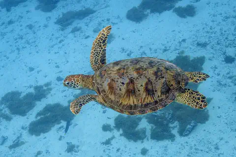
Christopher Columbus saw the islands in 1503, and the Spanish first named them Las Tortugas, for the many turtles in the surrounding waters. Today, snorkelers watch stingrays in the shallow water off Grand Cayman. The turtle photo was taken near Moorea, in French Polynesia, and the stingray photo in the US Virgin Islands.
The National Trust for the Cayman Islands, founded in 1987, calls the blue iguana Grand Cayman's largest endemic land animal and runs a captive breeding programme for this endangered species, with the Salina and Colliers wilderness reserves. Along the Mastic Trail the Trust lists birds, butterflies, nonvenomous snakes, frogs, crabs and lizards.
Britannica records that the Spaniards first named the islands Las Tortugas for the many turtles in the surrounding waters, and that Columbus noted green sea turtles there; it adds that the islands are rich in birdlife. Snorkelers watch stingrays off Grand Cayman. The green turtle photo is from Moorea, French Polynesia, and the stingray photo shows a southern stingray off St. Croix, US Virgin Islands.
A fast-growing island community
People speak English on the islands. Many visitors come to swim and dive.
Cassava cake is a well-known Caymanian food.
The number of people living in the Cayman Islands has grown fast. The 2021 census counted 71,105 people, and by the end of 2025 the statistics office estimated 90,577.
English is the official language. The statistics office says tourism and financial services, such as banking, helped the economy grow in the first months of 2026, and divers come for the reefs. Under the Education Act, children must get a full-time education from age 5 until they turn 17 or earn a secondary school diploma.
The Economics and Statistics Office reports a census population of 71,105 (October 2021) and an estimated 90,577 in December 2025, along with life expectancy at birth of 83.4 years (2025). Britannica notes that the territory's settlers included British mariners, privateers, shipwrecked passengers, enslaved Africans and land-grant holders from Jamaica.
In its 2026 update the statistics office credited strong tourism and continued growth in financial services for economic growth in the first quarter. English is official and the main spoken language, heard in a variety of dialects. The Education Act (2024 Revision) sets the compulsory school age from 5 until 17 or a secondary school diploma, whichever comes first; the University College of the Cayman Islands dates from 1975.
Las Tortugas to a modern constitution
Long ago, the explorer Columbus sailed past the islands.
Later, British settlers came. Today the islands make many of their own decisions.
Christopher Columbus sighted the islands in 1503, on his last voyage. The Spanish first called them Las Tortugas, after the turtles, but by 1530 they were named after caimans, relatives of alligators that people said lived there.
In 1670 a treaty gave the islands to Britain, and the first lasting settlement grew on Grand Cayman. For a long time the islands were run from Jamaica. When Jamaica became independent in 1962, the Caymans stayed with Britain, and in 2009 people voted for a new constitution.
Columbus sighted the islands on 10 May 1503, during his last voyage to the West Indies. The Spanish name Las Tortugas gave way by 1530 to Caimanas or Caymanes, for the caimans reported there. The Treaty of Madrid (1670) ceded the Caymans, with Jamaica, to Great Britain, after which the first permanent settlement was made on Grand Cayman. Enslaved people were emancipated in 1835.
Long a dependency of Jamaica, the islands became internally self-governing in July 1959 and reverted to direct British rule when Jamaica became independent in 1962. A 1972 constitution gave autonomy on most domestic issues; by then offshore banking and tourism allowed the colony to give up British aid. The constitution was revised in 1994, and a new one, approved by referendum in May 2009, came into effect that year.
The Cayman Islands on the map
Find the Caribbean Sea on the globe.
Look between Cuba and Jamaica, a little to the west. Three small islands sit in the sea. Those are the Cayman Islands.
The Cayman Islands lie in the western Caribbean Sea, about 19 degrees north of the equator, south of Cuba and about 290 kilometers northwest of Jamaica.
They have no land borders. The islands are too small for the globe to draw, so PlayOwl marks them with dots: George Town, Bodden Town and the Botanic Park on Grand Cayman, then Little Cayman and Cayman Brac to the northeast.
The islands lie at about 19.3° N, 81.4° W (George Town), 290 km northwest of Jamaica, on the submarine ridge that runs from Belize toward Cuba. Cayman Brac is 143 km northeast of Grand Cayman, and Little Cayman 8 km west of Cayman Brac. There are no land borders.
At the globe's scale the islands have no outlines, so the map uses markers: George Town, Bodden Town and the Queen Elizabeth II Botanic Park on Grand Cayman, Little Cayman, and Cayman Brac.
- Grand Cayman
- 35 × 13 km
- Highest point
- Cayman Brac's bluff, 42 m
- People (estimate, Dec 2025)
- 90,577
- Distance to Jamaica
- about 290 km
Amazing facts
-
The Cayman Islands were first named after turtles.
The Spanish first called the islands Las Tortugas because so many turtles swam around them. By 1530 they were named after caimans instead.
The Spanish name Las Tortugas, for the turtles in the surrounding waters, gave way by 1530 to Caimanas or Caymanes, after the caimans reported there.
-
A rare blue iguana lives only on Grand Cayman.
The blue iguana is Grand Cayman's largest land animal that lives nowhere else in the world.
The National Trust describes the endangered blue iguana as Grand Cayman's largest endemic land animal and runs a captive breeding program for it, with wilderness reserves at Salina and Colliers.
-
The Cayman Islands have no rivers.
Not one river flows on any of the three Cayman Islands.
The low limestone islands have no rivers; George Town receives about 1,500 mm of rain a year, and the other islands less.
-
Some rocks on the shore are full of fossils of sea animals.
Much of the coast is "ironshore," limestone packed with fossils of sea creatures.
Ironshore, the limestone fringe along much of the Caymans' coast, contains numerous marine fossils.
Words to know
- overseas territory
- a place far from a country's main land that belongs to that country and governs itself in many ways
- ironshore
- rocky limestone along a shore, full of fossils
- endemic
- found naturally in one place and nowhere else
- tectonic plate
- one of the huge slabs of rock that make up Earth's outer shell and slowly move
- caiman
- an animal related to alligators and crocodiles
- estimate
- a careful best guess of a number, made when it has not just been counted
Discovery challenge
-
Which lizard lives only on Grand Cayman?
Which endangered lizard is found only on Grand Cayman?
Which reptile does the National Trust call Grand Cayman's largest endemic land animal?
- The blue iguana
- The Komodo dragon
- The chameleon
Show the answer
The blue iguana
The blue iguana.
The blue iguana, which the National Trust breeds and protects.
The blue iguana, an endangered species bred in captivity for protected reserves.
-
What did the Spanish first call the islands?
The Spanish first named the islands after which animals?
Which animals gave the islands their first Spanish name, Las Tortugas?
- Parrots
- Turtles
- Sharks
Show the answer
Turtles
Turtles! Las Tortugas means the turtles.
Turtles. They called them Las Tortugas.
Turtles; the name later changed to Caimanas, after caimans.
-
Which island country is close to the Cayman Islands?
The Cayman Islands lie about 290 kilometers northwest of which island country?
Until 1962 the Cayman Islands were a dependency of which country, 290 km to their southeast?
- Iceland
- Japan
- Jamaica
Show the answer
Jamaica
Jamaica is nearest.
Jamaica, to the southeast.
Jamaica; when it became independent in 1962, the Caymans reverted to direct British rule.
-
How many rivers do the Cayman Islands have?
How many rivers flow on the Cayman Islands?
How many rivers do the low limestone Cayman Islands have?
- None
- Three
- More than 100
Show the answer
None
None at all!
None. The islands are low limestone with no rivers.
None; the islands are low-lying limestone with no rivers.
Places to discover in Cayman Islands
Animals of Cayman Islands
-
Watch
Animal
Green sea turtle
The green sea turtle is the largest sea turtle with a hard shell. It lives in warm seas around the world and, unlike other sea turtles, grown-ups eat mostly seagrass and algae. Females swim hundreds or even thousands of kilometers to lay their eggs on the beaches where they hatched long ago.
-
 Watch
Animal
Southern stingray
The southern stingray is a flat, diamond-shaped ray of warm western Atlantic waters, from the eastern United States through the Gulf of Mexico and the Caribbean to South America. It spends much of its time on sandy bottoms, finding buried crabs, shrimp and fish by smell, touch and tiny electric signals.
Explore next
-
 Watch
 Country
Jamaica
Jamaica is the third largest island in the Caribbean Sea, south of Cuba. The Blue Mountains rise in the east, and limestone hills full of caves and sinkholes cover much of the west. Most Jamaicans are descended from enslaved Africans, and the island is known worldwide for reggae music and sprinters. The 2022 census counted 2,774,538 people.
-
 Watch
 Country
Cuba
Cuba is the largest island in the Caribbean, a long, narrow country with about 1,600 smaller islands and cays around it. It has mountains, green valleys, coral reefs and the old city of Havana, its capital. About 9.4 million people lived there at the end of 2025, and Spanish is the main language.
-
 Watch
 Country
United Kingdom
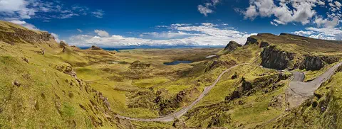
The United Kingdom, or UK, lies on islands off the northwest coast of Europe. It is made up of four parts, England, Scotland, Wales and Northern Ireland, and about 69.5 million people live there. Its capital is London.
-
 Watch
Natural wonder
Caribbean Sea
The US National Hurricane Center counts the Caribbean Sea as part of the Atlantic basin. Along the coast of Belize lies the largest barrier reef in the northern hemisphere, UNESCO says. Far below, in the Cayman Trough, the sea floor is slowly spreading apart, and scientists have found hot springs there almost 5,000 meters down.
-
Watch
Animal
Green sea turtle
The green sea turtle is the largest sea turtle with a hard shell. It lives in warm seas around the world and, unlike other sea turtles, grown-ups eat mostly seagrass and algae. Females swim hundreds or even thousands of kilometers to lay their eggs on the beaches where they hatched long ago.
-
Watch
Animal
Southern stingray
The southern stingray is a flat, diamond-shaped ray of warm western Atlantic waters, from the eastern United States through the Gulf of Mexico and the Caribbean to South America. It spends much of its time on sandy bottoms, finding buried crabs, shrimp and fish by smell, touch and tiny electric signals.
- Watch Geography Islands An island is a piece of land surrounded by water that is smaller than a continent. Islands form in different ways: some broke away from continents, some were built by volcanoes on the sea floor, and some were made by corals or by waves piling up sand. Because they are cut off by water, islands often have unusual plants and animals.
-
 Watch
 Country
United States
The United States is a large country in North America made of 50 states, from icy Alaska to the warm islands of Hawaii. It has the Grand Canyon, the Mississippi River and Yellowstone, and about 342 million people live there.
For parents & teachers
What children will learn
- Locate the Cayman Islands in the Caribbean and name the three islands.
- Explain what a British overseas territory is and who is responsible for what.
- Describe ironshore, coral reefs and why the blue iguana needs protection.
- Outline the islands' history from 1503 to the 2009 constitution.
Recommended ages: 3 to 17 · About 15 minutes
Talk about it
- The population grew from about 71,000 to about 90,000 in four years. What would a small island need to build when that many people arrive?
- Why might people breed an endangered animal and look after wild reserves for it?
- The islands were first named after turtles. What animal might your town be named after?
Try at home or in class
- Look at a piece of limestone, chalk or a seashell with a magnifying glass, and imagine how fossils end up inside rock like ironshore.
- On a map, measure the distances from Grand Cayman to Jamaica and to Cuba. Which is closer?
Key vocabulary: overseas territory, ironshore, endemic, tectonic plate, caiman, estimate
Where these facts come from
- Wikidata , Wikimedia Foundation (CC0 1.0)
- Natural Earth vector data , Natural Earth (NACIS) (Public domain)
- Cayman Islands (land, climate, plant and animal life, people, economy) , Encyclopaedia Britannica
- Cayman Islands: government and society, history , Encyclopaedia Britannica
- Economics and Statistics Office: key indicators (census population, estimated population) , Cayman Islands Government, Economics and Statistics Office
- National Trust for the Cayman Islands , National Trust for the Cayman Islands
- Tours: Blue Iguana Conservation and the Mastic Trail , National Trust for the Cayman Islands
- Adopt a Blue Iguana , National Trust for the Cayman Islands
- Education Act (2024 Revision) , Cayman Islands Government, Ministry of Education
- PlayOwl region table, version 1 , PlayOwl (PlayOwl original data)
- flag-icons 7.5.0 , Panayiotis Lipiridis and contributors (MIT)
- Wikimedia Commons , Wikimedia Foundation (Per file (public domain, CC0, CC BY or CC BY-SA); see each media record)
Checked, not yet human-reviewed. Last updated November 1, 2026. Spotted a mistake? Tell us.