
 Country
North America
Dominican Republic
The Dominican Republic is a country on a big island in the Caribbean Sea. It has the tallest mountain in the Caribbean. People there speak Spanish.
The Dominican Republic covers the eastern two-thirds of the island of Hispaniola, which it shares with Haiti. It has the highest mountain and the lowest lake in the West Indies, sandy beaches, and Santo Domingo, the oldest European-founded city in the Americas. The 2022 census counted about 10.8 million people.
The Dominican Republic occupies the eastern two-thirds of Hispaniola, the second largest island of the Greater Antilles. Its capital, Santo Domingo, was the first permanent European town in the Americas, and its Colonial City has been a World Heritage Site since 1990. Independence was proclaimed in February 1844, after more than two decades of Haitian rule. The 2022 census counted 10,773,983 people in its final results.
Photo: Jjc09, public domain, via Wikimedia Commons
Discover the Dominican Republic
The Dominican Republic is on an island called Hispaniola.
It shares the island with Haiti. The sea is all around. The capital city is Santo Domingo.
The Dominican Republic is in the Caribbean, on the island of Hispaniola. Haiti covers the western third of the island, and the Dominican Republic covers the eastern two-thirds. The Caribbean Sea washes its southern shore and the Atlantic Ocean its northern shore.
The country also includes smaller islands such as Saona, Beata and Catalina. Its land is about half the size of Portugal. Spanish is the official language, and the first results of the 2022 census counted about 10.8 million people.
Britannica places the Dominican Republic on the eastern two-thirds of Hispaniola, the second largest island of the Greater Antilles. The Mona Passage, about 130 km wide, separates it from Puerto Rico; the Turks and Caicos Islands lie some 145 km north and Colombia about 500 km south. Some writers, Britannica notes, call the country a microcosm of Latin America.
The National Statistics Office (ONE) carried out the tenth national census in 2022; its preliminary results (August 2023) counted 10,760,028 inhabitants, and the final results presented in June 2024 counted 10,773,983, about 1.3 million more than in 2010. Wikidata gives an area of 48,671 km², including the adjacent islands. Spanish is the official language, and the currency is the Dominican peso.
Santo Domingo, Santiago and the Cibao
Santo Domingo is the capital city.
It is by the sea. It is very old. The photo shows its tall buildings from above.
Santo Domingo, on the south coast, is the largest city. Spanish settlers founded it in the 1490s, so it is the oldest city built by Europeans in the Americas. Its old Colonial City has the first cathedral, hospital, customs house and university in the Americas. The photo looks over the modern city from a tall tower.
Santiago, in the green Cibao Valley, is the second largest city. Other towns include La Vega, San Francisco de Macorís, Puerto Plata on the north coast, and La Romana in the southeast.
Britannica dates Santo Domingo's founding to 1496 and calls it the first permanent town established by Europeans in the Americas; UNESCO, which inscribed its Colonial City in 1990, gives 1498 and notes that its grid plan became a model for town planners across the Americas. Its Spanish Renaissance cathedral was built between 1514 and 1542, and the city is the seat of the oldest Roman Catholic archbishopric in the Americas.
The Cibao Valley is densely settled around Santiago, the second city, which vies with the capital in politics, culture and business. Secondary centers include La Romana and San Pedro de Macorís in the southeast, Barahona in the southwest and Puerto Plata in the north. About four-fifths of Dominicans now live in cities and towns, after a steady move from the countryside since the mid-20th century.
The highest peak and the lowest lake
The Dominican Republic has tall mountains.
Pico Duarte is the tallest mountain in the Caribbean. There is also a very salty lake. It is lower than the sea!
Long mountain ranges and green valleys run across the country from northwest to southeast. In the Cordillera Central rises Pico Duarte, 3,101 meters high, the tallest mountain in the Caribbean.
In the southwest lies Lake Enriquillo, the country's largest natural lake. Its salty water sits about 44 meters below sea level, the lowest point in the West Indies. It is warm all year, about 25 °C on average. The northeast is the rainiest part, the southwest is dry, and hurricanes can strike from August to October.
Britannica notes that the country holds both the highest and lowest elevations in the West Indies. Ranges and fertile valleys trend northwest to southeast: the Cordillera Septentrional, the Cibao Valley (watered by the Yaque del Norte and Camú-Yuna systems), the Cordillera Central, the San Juan Valley, the Sierra de Neiba and the Sierra de Baoruco. Wikidata gives Pico Duarte 3,101 m.
Saline Lake Enriquillo, about 37 km long and up to 18 km wide, has its surface about 44 m below sea level. The northeast trade winds bring more than 2,540 mm of rain a year to the windward northeast, while western valleys near the Haitian border get less than 760 mm. The annual mean temperature is 25 °C, from 21 °C in the high Cordillera Central to 28 °C on the coastal plains. Pines and tropical hardwoods still cover much of the mountains, and royal palms grow throughout much of the country.

Crocodiles, iguanas and whales
Crocodiles swim in the salty lake.
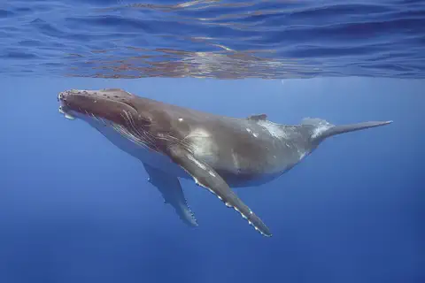
Iguanas with little horns live nearby. Pink flamingos visit too. Big humpback whales come to warm water to have babies.
Lake Enriquillo is home to a large group of American crocodiles. Rhinoceros iguanas, named for the horn-like scales on their snouts, live around the lake and are found only on Hispaniola. Flamingos and many migrating birds rest and feed there.
Every winter, humpback whales swim south to the warm waters of the Dominican Republic to mate and give birth. A marine mammal sanctuary protects them, and it is a sister sanctuary to one off Massachusetts in the United States. The crocodile in the photo was photographed in Mexico.
WWF's Hispaniola ecoregion profile calls Lake Enriquillo the largest and most hypersaline lake in the Antilles and home to the largest population of American crocodiles (Crocodylus acutus), though at risk; the rhinoceros iguana (Cyclura cornuta), endemic to Hispaniola, and Ricord's iguana also live there, and flamingos use it for resting, feeding and breeding. Britannica notes that wild mammals are not abundant.
NOAA Fisheries reports that it and the Dominican Ministry of Environment set up the world's first sister sanctuaries for humpback whales: Stellwagen Bank off Massachusetts and the Marine Mammal Sanctuary of the Dominican Republic. About 900 humpbacks feed at Stellwagen in spring and summer, then head south in late fall to mate and calve in Dominican waters. The crocodile photo is from Mexico and the whale photo from French Polynesia.

Merengue, baseball and Carnival
People in the Dominican Republic speak Spanish.
They love music and dancing. Merengue is a happy dance. Baseball is the national pastime.
Most Dominicans have both African and European ancestors, and many families also came from places such as Spain's Canary Islands, Italy, China, Japan and the Middle East. Spanish is spoken everywhere, and many families have relatives in the United States.
Music and dancing matter at every age, and merengue is the best-known music. Baseball is a passion, and many Dominican players have joined major league teams. Rice, beans, plantains, seafood and tropical fruits are everyday foods, and Carnival brings colorful homemade masks to the streets, especially in Santiago.
Britannica describes a population predominantly of mixed African and European ancestry, with small Black and white minorities; some scholars argue the Taíno legacy, long thought nearly erased, survives more strongly in genes, language and material culture. Immigrants came in the 19th and 20th centuries from France, Italy, England, Germany, East Asia, North Africa and the Middle East, and Japanese farmers settled in the Constanza valley before World War II. Spanish predominates; a French Creole is spoken among Haitian immigrants, and more than four-fifths of people are Roman Catholic.
Merengue, bolero and salsa are popular, with festivals in Santo Domingo and Puerto Plata. U.S. Marines introduced baseball, and from the 1960s players such as Juan Marichal and the Alou brothers reached the major leagues. Carnival, held in the weeks before Lent, is especially colorful in Santiago, where homemade masks are a recognized art form.
From the Taíno to independence
The Taíno people lived here first.
Later, people from Spain came by ship. In 1844 the Dominican Republic became its own country.
Taíno villages stood on the island long before Europeans came. Christopher Columbus arrived in 1492, and Spain built Santo Domingo soon after. Spanish settlers brought enslaved Africans to work in mines and on sugar farms.
From 1822 to 1844 the whole island was ruled from Haiti. In February 1844 a group led by Juan Pablo Duarte helped the country declare independence. Spain ruled again briefly in the 1860s, and later the country had long years of military rule and a harsh dictator. Today it is a republic with an elected president.
Arawak-speaking peoples, the Taíno, lived on the island in pre-Columbian times; after Columbus's arrival in 1492 most died from disease, warfare and forced labor. Settlement grew around sugar plantations, worked by enslaved West Africans. The west of the island became the French colony of Saint-Domingue, later independent Haiti, whose forces occupied the east from 1822 to 1844.
Juan Pablo Duarte's secret society La Trinitaria worked for independence, proclaimed in February 1844, but caudillos (military strongmen) such as Pedro Santana and Buenaventura Báez then dominated. Santana invited Spain back in 1861; Spain withdrew in 1865. Britannica lists U.S. military interventions (1916–24 and 1965–66) and the oppressive dictatorship of Rafael Trujillo (1930–61). National holidays on February 27 and August 16 mark the independence struggles; today the country is a multiparty republic with a two-house congress.
The Dominican Republic on the map
Find the Dominican Republic on the globe.
Look in the Caribbean Sea for a big island. The Dominican Republic is on its eastern side.
Look for Hispaniola, east of Cuba and west of Puerto Rico. The Dominican Republic covers the eastern two-thirds of the island, and Haiti the western third. Its only land border is with Haiti.
The Atlantic Ocean is to the north and the Caribbean Sea to the south. The Mona Passage, about 130 kilometers wide, separates it from Puerto Rico.
The Dominican Republic shares Hispaniola with Haiti, its only land neighbor, across a mountainous frontier. Wikidata gives 48,671 km² including islands such as Saona, Beata and Catalina; Britannica's quick facts give 48,223 km².
Its mountain ranges continue into Haiti under other names: the Cordillera Central becomes the Massif du Nord and the Sierra de Baoruco the Massif de la Selle. The San Juan Valley connects with Haiti's Central Plateau through the upper Artibonite River valley.
- Share of Hispaniola
- the eastern two-thirds
- Lake Enriquillo's surface
- about 44 m below sea level
- Width of the Mona Passage
- about 130 km
- People (2022 census)
- 10,773,983
Amazing facts
-
The tallest mountain in the Caribbean is in the Dominican Republic.
Pico Duarte, in the Cordillera Central, is the highest mountain in the Caribbean.
Britannica calls Duarte Peak, in the Cordillera Central, the highest mountain in the Caribbean; the country holds both the highest and the lowest points of the West Indies.
-
Santo Domingo had the first university in the Americas.
Santo Domingo was the site of the first cathedral, hospital, customs house and university in the Americas.
UNESCO notes that Santo Domingo had the Americas' first cathedral, hospital, customs house and university, and that its grid plan became a model for town planners in the New World.
-
Humpback whales visit to have their babies.
Humpback whales that feed off Massachusetts in summer swim to Dominican waters in winter to mate and give birth.
NOAA Fisheries says the Dominican Republic's marine mammal sanctuary and Stellwagen Bank, 3,000 miles apart, were the world's first sister sanctuaries for humpback whales.
-
Carnival masks are made by hand.
During Carnival in Santiago, people wear homemade masks, which are a recognized art form in the country.
Britannica notes that Carnival masks, usually homemade, are a recognized art form in the Dominican Republic, and that Carnival is especially colorful in Santiago.
Words to know
- island
- land with water all around it
- hypersaline
- much saltier than seawater
- colonial
- from the time when a place was ruled by a faraway country
- merengue
- a lively style of music and dance from the Dominican Republic
- sanctuary
- a protected place where animals are kept safe
- trade winds
- steady winds that blow toward the equator from the east
Discovery challenge
-
Which country shares an island with the Dominican Republic?
The Dominican Republic shares Hispaniola with which country?
Which country occupies the western third of Hispaniola?
- Cuba
- Haiti
- Jamaica
Show the answer
Haiti
Haiti is on the other side of the island.
Haiti covers the western third of Hispaniola.
Haiti; the Dominican Republic holds the eastern two-thirds.
-
What is the tallest mountain in the Dominican Republic?
Which peak is the tallest mountain in the Caribbean?
Which peak in the Cordillera Central is the highest in the West Indies?
- Pico Duarte
- Mount Everest
- Blue Mountain Peak
Show the answer
Pico Duarte
Pico Duarte is the tallest.
Pico Duarte, 3,101 meters high.
Pico Duarte (Duarte Peak), 3,101 m according to Wikidata.
-
Which animal lives in salty Lake Enriquillo?
Which big reptile lives in Lake Enriquillo?
Lake Enriquillo holds the largest population of which reptile?
- The polar bear
- The American crocodile
- The penguin
Show the answer
The American crocodile
Crocodiles live in the lake.
American crocodiles live in the lake.
Crocodylus acutus, according to WWF's ecoregion profile.
-
What language do people speak in the Dominican Republic?
What is the official language of the Dominican Republic?
Which language has always been predominant in the Dominican Republic?
- French
- English
- Spanish
Show the answer
Spanish
People speak Spanish.
Spanish is the official language.
Spanish; a French Creole is spoken among Haitian immigrants.
Places to discover in Dominican Republic
-
Watch
City
Santo Domingo
Santo Domingo is the capital of the Dominican Republic, at the mouth of the Ozama River on the south coast of the island of Hispaniola. It was founded in 1498, and UNESCO calls its Colonial City the first permanent establishment of the 'New World'. At the 2022 census, 1,029,110 people lived in its National District.
-
Watch
Natural wonder
Caribbean Sea
The US National Hurricane Center counts the Caribbean Sea as part of the Atlantic basin. Along the coast of Belize lies the largest barrier reef in the northern hemisphere, UNESCO says. Far below, in the Cayman Trough, the sea floor is slowly spreading apart, and scientists have found hot springs there almost 5,000 meters down.
-
 Watch
Natural wonder
Hispaniola
Hispaniola is a Caribbean island built from pieces of old volcanic island chains and ocean crust, squeezed together where two plates of Earth's crust meet. Major faults cross it, mountains rise to about 3,100 meters at Pico Duarte, and a salty lake in a deep valley is home to crocodiles and rare iguanas.
Animals of Dominican Republic
-
Watch
Animal
American crocodile
The American crocodile is a large reptile of warm coasts and mangrove swamps, from the southern tip of Florida through Mexico, Central America, the Caribbean and northern South America. It is shy, it basks in the sun to warm up, and mother crocodiles carry their babies to the water.
-
 Watch
3D
Animal
Humpback whale
The humpback whale is a baleen whale famous for leaping out of the water, slapping its giant flippers and singing long, complex songs. It lives in every ocean and makes one of the longest journeys of any mammal, between cold feeding waters and warm waters where calves are born. Once hunted almost to extinction, it is now recovering.
-
 Watch
Animal
American flamingo
The American flamingo is a tall, bright pink wading bird of the Caribbean. It gets its color from pigments in the tiny water animals and algae it eats, and it feeds by filtering water through its bent bill with its head upside down. Flamingos live and nest in huge, noisy groups.
Explore next
-
Watch
City
Santo Domingo
Santo Domingo is the capital of the Dominican Republic, at the mouth of the Ozama River on the south coast of the island of Hispaniola. It was founded in 1498, and UNESCO calls its Colonial City the first permanent establishment of the 'New World'. At the 2022 census, 1,029,110 people lived in its National District.
-
Watch
Natural wonder
Hispaniola
Hispaniola is a Caribbean island built from pieces of old volcanic island chains and ocean crust, squeezed together where two plates of Earth's crust meet. Major faults cross it, mountains rise to about 3,100 meters at Pico Duarte, and a salty lake in a deep valley is home to crocodiles and rare iguanas.
-
Watch
Natural wonder
Caribbean Sea
The US National Hurricane Center counts the Caribbean Sea as part of the Atlantic basin. Along the coast of Belize lies the largest barrier reef in the northern hemisphere, UNESCO says. Far below, in the Cayman Trough, the sea floor is slowly spreading apart, and scientists have found hot springs there almost 5,000 meters down.
-
 Watch
 Country
Haiti
Haiti covers the western third of the island of Hispaniola in the Caribbean. Its name comes from an old word meaning mountainous land. In 1804, after enslaved people freed themselves, Haiti became independent, and its people created their own language, art and music. About 11.9 million people lived there in 2024.
-
Watch
Animal
American crocodile
The American crocodile is a large reptile of warm coasts and mangrove swamps, from the southern tip of Florida through Mexico, Central America, the Caribbean and northern South America. It is shy, it basks in the sun to warm up, and mother crocodiles carry their babies to the water.
-
Watch
3D
Animal
Humpback whale
The humpback whale is a baleen whale famous for leaping out of the water, slapping its giant flippers and singing long, complex songs. It lives in every ocean and makes one of the longest journeys of any mammal, between cold feeding waters and warm waters where calves are born. Once hunted almost to extinction, it is now recovering.
-
Watch
Animal
American flamingo
The American flamingo is a tall, bright pink wading bird of the Caribbean. It gets its color from pigments in the tiny water animals and algae it eats, and it feeds by filtering water through its bent bill with its head upside down. Flamingos live and nest in huge, noisy groups.
-
 Watch
 Country
Puerto Rico
Puerto Rico is the easternmost island of the Greater Antilles, a self-governing commonwealth associated with the United States. Its people have been US citizens since 1917. It has mountains, the El Yunque rain forest and the old forts of San Juan, a World Heritage site. The US Census Bureau estimated 3,184,835 people in 2025.
For parents & teachers
What children will learn
- Locate the Dominican Republic on Hispaniola and name its neighbor, Haiti.
- Describe its mountains, valleys and Lake Enriquillo, the lowest point in the West Indies.
- Explain why Santo Domingo's Colonial City is a World Heritage Site.
- Outline the path from Taíno villages and Spanish rule to independence in 1844.
Recommended ages: 3 to 17 · About 15 minutes
Talk about it
- Why might the northeast of the island be rainier than the southwest?
- What can a very old city teach us about how people lived long ago?
- Why would two sanctuaries far apart work together to protect the same whales?
Try at home or in class
- Stir salt into a glass of water until no more dissolves, then compare how an egg or a grape floats in fresh and salty water, to explore a hypersaline lake.
- Listen to a merengue song with a grown-up and clap along to the beat.
Key vocabulary: island, hypersaline, colonial, merengue, sanctuary, trade winds
Where these facts come from
- Wikidata , Wikimedia Foundation (CC0 1.0)
- Natural Earth vector data , Natural Earth (NACIS) (Public domain)
- UNESCO World Heritage List , UNESCO World Heritage Centre (Linked as a reference; site facts come from Wikidata)
- Dominican Republic (introduction, land, climate, plant and animal life) , Encyclopaedia Britannica
- Dominican Republic: Settlement patterns (ethnic groups, languages, religion) , Encyclopaedia Britannica
- Dominican Republic: Daily life and social customs (food, music, Carnival, baseball) , Encyclopaedia Britannica
- Dominican Republic: Caudillos (1844 to 1899) , Encyclopaedia Britannica
- Juan Pablo Duarte , Encyclopaedia Britannica
- Santo Domingo (founding by Bartholomew Columbus, cathedral 1514-42) , Encyclopaedia Britannica
- Colonial City of Santo Domingo , UNESCO World Heritage Centre
- Caribbean: Island of Hispaniola (ecoregion profile) , WWF
- Humpback whale , NOAA Fisheries
- ONE informa los primeros resultados preliminares del X Censo Nacional de Población y Vivienda , Presidencia de la República Dominicana
- Censo descubrió descenso en tasa de crecimiento de población dominicana (X Censo 2022 final results) , Diario Libre
- PlayOwl region table, version 1 , PlayOwl (PlayOwl original data)
- flag-icons 7.5.0 , Panayiotis Lipiridis and contributors (MIT)
- Wikimedia Commons , Wikimedia Foundation (Per file (public domain, CC0, CC BY or CC BY-SA); see each media record)
Checked, not yet human-reviewed. Last updated November 1, 2026. Spotted a mistake? Tell us.
Picture credits
- Photo: Jjc09, public domain, via Wikimedia Commons · source
- Photo: Martin Falbisoner, CC BY-SA 4.0, via Wikimedia Commons · source · license
- Photo: Tomás Castelazo, CC BY-SA 2.5, via Wikimedia Commons · source · license
- Photo: Adrian Pingstone, public domain, via Wikimedia Commons · source
- Photo: Charles J. Sharp, CC BY-SA 4.0, via Wikimedia Commons · source · license