
 Country
North America
Puerto Rico
Puerto Rico is a warm island in the Caribbean Sea. It has a rain forest and old stone forts. A tiny frog there sings "co-kee!" People speak Spanish and English.
Puerto Rico is the easternmost island of the Greater Antilles, a self-governing commonwealth associated with the United States. Its people have been US citizens since 1917. It has mountains, the El Yunque rain forest and the old forts of San Juan, a World Heritage site. The US Census Bureau estimated 3,184,835 people in 2025.
Puerto Rico, the Taíno Boriquén, was claimed for Spain in 1493 and ceded to the United States in 1898; Puerto Ricans gained US citizenship in 1917 and adopted their own constitution in 1952 as the Commonwealth of Puerto Rico, a self-governing commonwealth associated with the United States. Spanish and English are official. The Census Bureau's estimate for July 1, 2025 is 3,184,835 people.
Photo: Aretemetic, CC BY-SA 3.0, via Wikimedia Commons
Discover Puerto Rico
Puerto Rico is an island in the Caribbean Sea.
It has mountains, beaches and big cities. Most people speak Spanish.
Puerto Rico is the easternmost island of the Greater Antilles. It lies about 80 kilometers east of the Dominican Republic and about 1,600 kilometers southeast of Florida, with the Atlantic Ocean on its north shore and the Caribbean Sea to the south. The smaller islands of Vieques, Culebra and Mona are part of it too.
It is a commonwealth associated with the United States, and the money is the US dollar. Spanish and English are both official languages. The capital is San Juan. The Census Bureau estimated 3,184,835 people in 2025. The photo shows a street of colorful houses in Old San Juan.
The main island is roughly rectangular, up to 179 km east to west and 63 km north to south, about 80 km east of the Dominican Republic and 65 km west of the Virgin Islands; Vieques, Culebra and Mona are part of Puerto Rico. Its official name is Estado Libre Asociado de Puerto Rico in Spanish and Commonwealth of Puerto Rico in English.
The 2020 census counted 3,285,874 people, 11.8 percent fewer than in 2010, but a later Census Bureau survey found the count had overstated the population by about 5.7 percent. The bureau's Vintage 2025 estimate for July 1, 2025 is 3,184,835. The photo shows colorful houses with balconies on a cobblestone street in Old San Juan.
San Juan, El Morro and Ponce
San Juan is the capital city. Big old stone forts guard its bay.
Some of the forts are more than 400 years old.
San Juan, on the north coast, is the capital and has a large, well-protected bay. In the 1500s Spain built La Fortaleza, a fortified palace for the governor, and then the huge castle of San Felipe del Morro, called El Morro, to guard the narrow entrance to the harbor. Later came the larger fortress of San Cristóbal and a thick stone city wall, parts of which still stand.
UNESCO lists La Fortaleza and the San Juan National Historic Site as a World Heritage site. Ponce is a city on the south coast.
Juan Ponce de León founded Caparra beside the bay in 1508; by 1521 the town moved to an islet at the harbor's north end and was named Puerto Rico ('Rich Port'), a name that later passed to the whole island while the city became San Juan. Using a subsidy from Mexican mines, Spain built La Fortaleza, then El Morro to command the harbor entrance, then San Cristóbal on the Atlantic side; in the early 17th century a wall 8 m high and 5 m thick enclosed the city, and two parts survive.
UNESCO inscribed La Fortaleza and San Juan National Historic Site in 1983 as defenses built between the 16th and 20th centuries, a fine display of European military architecture adapted to harbors in the Americas. Most people live on the narrow lowland along the north coast.
Mountains, caves and a rain forest
Puerto Rico has green mountains in the middle.
In the northeast there is a rain forest called El Yunque.
Mountains and hills cover most of Puerto Rico. The Cordillera Central runs east to west, and its highest peak, Cerro de Punta, reaches 1,338 meters. In the northwest the land has sinkholes, caves and round haystack hills called mogotes.
El Yunque National Forest, in the northeast, is the only tropical rain forest in the US national forest system. It rains far more on the north side of the island than the south: San Juan gets about 1,525 millimeters a year and Ponce, on the south coast, only about 914. Hurricanes can come between June and November.
Nearly a quarter of the island is steep slopes. The Cordillera Central exceeds 900 m in many places and peaks at Cerro de Punta (1,338 m); the Sierra de Luquillo rises to 1,065 m at El Yunque Peak. Northwestern karst has sinkholes, caverns and mogotes. Less than 160 km north lies the Puerto Rico Trench, more than 8 km deep, the Atlantic's deepest point; tectonic forces still occasionally cause earthquakes on the island.
Northeast trade winds bring rain to the north while the south lies in a rain shadow: about 1,525 mm a year at San Juan, 4,570 mm at El Yunque Peak and 914 mm at Ponce. El Yunque National Forest, nearly 29,000 acres across eight municipalities, is the only tropical rainforest in the US national forest system.
The coquí and the Puerto Rican parrot
A tiny frog called the coquí sings "co-kee!"
Its song sounds like its name. A small green parrot lives in the forest.
The coquí is a small frog whose name sounds like its call, "co-kee!" It has become a kind of national mascot. The rain forest in the Sierra de Luquillo protects rare orchids and the small green Puerto Rican parrot, which is endangered.
Puerto Rico has more than 200 kinds of birds. Most land animals are small: nonpoisonous snakes, lizards and mongooses. Bright flowering trees such as the royal poinciana and the African tulip tree add patches of red and orange to the green mountains.
The coquí (genus Eleutherodactylus), named for its call, has become a national mascot. The forest of the Sierra de Luquillo preserves rare orchids and the endangered Puerto Rican parrot. More than 200 bird species are recorded, while land animals are mostly nonpoisonous snakes, lizards, mongooses and frogs.
Most of the original vegetation was cleared over centuries of farming, especially in the early 20th century, when coastal forests were cut for railroad ties and fuel; some woodlands have been replanted, but introduced trees, shrubs and grasses now dominate. Rain forest covers parts of the north and thorn and scrub the drier south.
Puerto Ricans
Most people speak Spanish. English is an official language too.
Most people live in towns and cities along the north coast.
Puerto Rican culture blends Spanish, US and Afro-Caribbean influences. Spanish and English are both official languages. Most people live on the narrow lowland along the north coast, and smaller crowded areas line the south and west coasts.
In Spanish colonial times, country people called jíbaros farmed their own small plots in the hills. The population has been getting smaller: the census counted 3,725,789 people in 2010 and 3,285,874 in 2020.
Puerto Ricans share an intermingled Spanish, US and Afro-Caribbean culture, and Spanish and English are both official. Most people live on the continuous narrow lowland of the north coast, with smaller, densely populated bands along the south and west; the Caguas Basin south of San Juan is the largest of the mountain basins with level land for towns and farms.
In colonial times San Juan received Spain's attention, while the rural jíbaros, largely ignored, worked their own small landholdings and traded ginger, hides, sugarcane, tobacco and cattle with non-Spanish merchants despite Spain's rules. The census counted 3,725,789 people in 2010 and 3,285,874 in 2020, a fall of 11.8 percent.
From Boriquén to commonwealth
The Taíno people called the island Boriquén.
Spain ruled it for 400 years. Then it became linked to the United States.
The Taíno, who called the island Boriquén, lived in small villages and grew pineapples, cassava and sweet potatoes. Christopher Columbus arrived on November 19, 1493, and claimed it for Spain. In 1508 Juan Ponce de León founded the first town.
In 1898 Spain gave Puerto Rico to the United States after a war between the two countries. Puerto Ricans became US citizens in 1917. In 1952 they voted for their own constitution, creating the Commonwealth of Puerto Rico.
Hunter-gatherers reached the island more than 1,000 years before the Spanish, and Arawak peoples who developed Taíno culture had settled by 1000 CE; in the late 15th century some 20,000–50,000 Taíno lived on Boriquén. Columbus anchored on the west coast on November 19, 1493, naming it San Juan Bautista; Ponce de León founded Caparra in 1508.
US forces landed on July 25, 1898, during the Spanish-American War, and the Treaty of Paris of December 10, 1898 ceded Puerto Rico to the United States. The Jones-Shafroth Act of March 2, 1917 granted US citizenship and an elected two-house legislature. Under a 1950 act of Congress, voters adopted a constitution on March 3, 1952, approved by Congress on July 3, 1952; it set up the territory's own government, with three branches like the US federal system (Library of Congress).
Puerto Rico on the map
Find the Caribbean Sea on the globe.
Look for the big islands in the north. Puerto Rico is the last big island in the east.
Find the Greater Antilles, the big islands of the northern Caribbean: Cuba, Hispaniola, Jamaica and Puerto Rico. Puerto Rico is the easternmost of them, about 80 kilometers east of the Dominican Republic.
The Virgin Islands lie about 65 kilometers to the east. North of Puerto Rico is the Atlantic Ocean, and south of it the Caribbean Sea.
Puerto Rico lies in the northeastern Caribbean, about 80 km east of the Dominican Republic, 65 km west of the Virgin Islands and about 1,600 km southeast of Florida. It is one-fifth the size of the Dominican Republic, one-third the size of Haiti and slightly smaller than Jamaica. The Puerto Rico Trench lies less than 160 km to the north.
- Main island
- 179 × 63 km
- Cerro de Punta
- 1,338 m
- People (estimate, July 2025)
- 3,184,835
- Florida from Puerto Rico
- about 1,600 km
Amazing facts
-
The coquí frog says its own name.
The coquí frog's name copies its call, "co-kee!", and it has become a kind of national mascot.
The coquí's name is onomatopoeic, echoing its call ("co-kee!"); the frog has become a kind of national mascot.
-
The island's name means "rich port".
Puerto Rico means "Rich Port". It was first the name of the town that became San Juan, and later the whole island took it.
By 1521 the town was moved and renamed Puerto Rico ('Rich Port'); through usage the port became San Juan and the island Puerto Rico.
-
El Yunque is a rain forest looked after by the US Forest Service.
El Yunque is the only tropical rain forest in the US national forest system.
At nearly 29,000 acres, El Yunque is one of the smallest US national forests but the only tropical rainforest in the system, and one of the most biologically diverse.
-
The deepest part of the Atlantic Ocean is near Puerto Rico.
The Puerto Rico Trench, north of the island, goes down more than 8 kilometers: the deepest point in the Atlantic.
The Puerto Rico Trench descends more than 8 km, the Atlantic's deepest point, at a site northeast of the Dominican Republic, less than 160 km north of Puerto Rico.
Words to know
- commonwealth
- Puerto Rico's official name for its self-governing link with the United States
- territory
- an area that belongs to a country but is not one of its states
- rain shadow
- a dry area on the side of mountains away from the rainy wind
- karst
- land of limestone worn into caves, sinkholes and steep hills
- trench
- a long, very deep valley in the ocean floor
- jíbaro
- a country person of Puerto Rico's hills who farmed a small plot in colonial times
Discovery challenge
-
What does the coquí frog say?
Where does the coquí frog's name come from?
Why is the coquí's name described as onomatopoeic?
- Its call sounds like "co-kee"
- It is named after a city
- It is named after a scientist
Show the answer
Its call sounds like "co-kee"
It sings "co-kee!"
Its name copies its call.
The name echoes its call, "co-kee!"
-
Which rain forest is in Puerto Rico?
Which is the only tropical rain forest in the US national forest system?
Which national forest in the Sierra de Luquillo is the only tropical rainforest in the US national forest system?
- El Yunque
- Yosemite
- The Everglades
Show the answer
El Yunque
El Yunque!
El Yunque National Forest.
El Yunque, nearly 29,000 acres.
-
What did Spain build to guard San Juan?
What is El Morro in San Juan?
What did Spain build at the narrow entrance to San Juan's harbor?
- A huge stone castle
- A bridge
- A lighthouse ship
Show the answer
A huge stone castle
A big stone castle!
A huge castle guarding the harbor entrance.
Castillo San Felipe del Morro, part of a World Heritage site since 1983.
-
In which year did Puerto Ricans become US citizens?
Which law year made Puerto Ricans US citizens?
In which year did the Jones-Shafroth Act grant US citizenship to Puerto Ricans?
- 1493
- 1917
- 1983
Show the answer
1917
In 1917.
1917.
March 2, 1917.
Places to discover in Puerto Rico
-
 Watch
City
San Juan
San Juan is the capital of Puerto Rico, on the island's north coast in the Caribbean. Its old town keeps a stone city wall and old forts that UNESCO lists as World Heritage. The 2020 census counted 342,263 people in San Juan.
-
 Watch
Natural wonder
Caribbean Sea
The US National Hurricane Center counts the Caribbean Sea as part of the Atlantic basin. Along the coast of Belize lies the largest barrier reef in the northern hemisphere, UNESCO says. Far below, in the Cayman Trough, the sea floor is slowly spreading apart, and scientists have found hot springs there almost 5,000 meters down.
Animals of Puerto Rico
-
 Watch
Animal
West Indian manatee
The West Indian manatee is a large, slow, plant-eating marine mammal nicknamed the sea cow. It lives in warm coasts, rivers and springs from Florida and the Caribbean to Brazil, grazing on seagrass and other water plants for up to 8 hours a day. It cannot stand cold water for long, and being hit by boats is one of the dangers it faces.
-
 Watch
3D
Animal
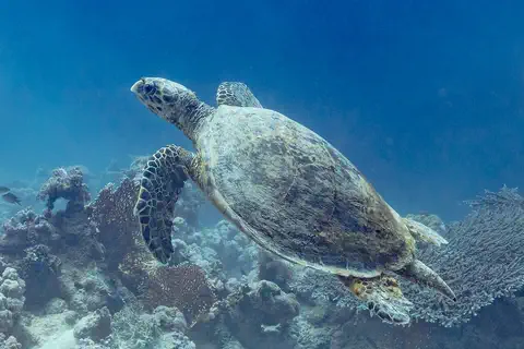
Hawksbill sea turtle
The hawksbill sea turtle lives in warm seas around the world, mostly near coral reefs. Its pointed, hawk-like beak reaches into cracks in the reef to find sponges, its favorite food. Its beautiful patterned shell once made it a target for hunters, and today it is critically endangered.
-
 Watch
Animal
Common coquí
The common coquí is a small brown frog from Puerto Rico whose males make a loud 'co-qui' call at night. It has no tadpole stage: tiny froglets hatch straight out of the eggs, which the father guards in a hidden nest. It is the most common frog in Puerto Rico, and people have also carried it to Hawaii and other places. In Hawaii it has become a problem.
Explore next
-
Watch
City
San Juan
San Juan is the capital of Puerto Rico, on the island's north coast in the Caribbean. Its old town keeps a stone city wall and old forts that UNESCO lists as World Heritage. The 2020 census counted 342,263 people in San Juan.
-
Watch
Natural wonder
Caribbean Sea
The US National Hurricane Center counts the Caribbean Sea as part of the Atlantic basin. Along the coast of Belize lies the largest barrier reef in the northern hemisphere, UNESCO says. Far below, in the Cayman Trough, the sea floor is slowly spreading apart, and scientists have found hot springs there almost 5,000 meters down.
-
 Watch
 Country
Dominican Republic
The Dominican Republic covers the eastern two-thirds of the island of Hispaniola, which it shares with Haiti. It has the highest mountain and the lowest lake in the West Indies, sandy beaches, and Santo Domingo, the oldest European-founded city in the Americas. The 2022 census counted about 10.8 million people.
-
 Watch
 Country
United States
The United States is a large country in North America made of 50 states, from icy Alaska to the warm islands of Hawaii. It has the Grand Canyon, the Mississippi River and Yellowstone, and about 342 million people live there.
-
Watch
Animal
West Indian manatee
The West Indian manatee is a large, slow, plant-eating marine mammal nicknamed the sea cow. It lives in warm coasts, rivers and springs from Florida and the Caribbean to Brazil, grazing on seagrass and other water plants for up to 8 hours a day. It cannot stand cold water for long, and being hit by boats is one of the dangers it faces.
-
Watch
3D
Animal
Hawksbill sea turtle
The hawksbill sea turtle lives in warm seas around the world, mostly near coral reefs. Its pointed, hawk-like beak reaches into cracks in the reef to find sponges, its favorite food. Its beautiful patterned shell once made it a target for hunters, and today it is critically endangered.
-
 Watch
 Country
U.S. Virgin Islands
The U.S. Virgin Islands are a territory of the United States in the northeastern Caribbean Sea, about 64 kilometers east of Puerto Rico. The three main islands are St. Croix, St. Thomas and St. John. Denmark sold them to the United States in 1917. The 2020 census counted 87,146 people.
-
Watch
Animal
Common coquí
The common coquí is a small brown frog from Puerto Rico whose males make a loud 'co-qui' call at night. It has no tadpole stage: tiny froglets hatch straight out of the eggs, which the father guards in a hidden nest. It is the most common frog in Puerto Rico, and people have also carried it to Hawaii and other places. In Hawaii it has become a problem.
For parents & teachers
What children will learn
- Locate Puerto Rico at the eastern end of the Greater Antilles.
- Explain why the north of the island is rainy and the south dry.
- Describe San Juan's forts and why they are a World Heritage site.
- Outline the history from the Taíno to the 1952 constitution.
Recommended ages: 3 to 17 · About 15 minutes
Talk about it
- Why might a city build so many forts around one harbor?
- How can one place speak two official languages?
- Why do you think a small frog could become a symbol of a whole island?
Try at home or in class
- Make a rain-shadow model: blow across a damp sponge mountain toward a dry paper towel and see which side stays dry.
- Listen to recordings of frog calls with a grown-up and try to copy the coquí's "co-kee!"
Key vocabulary: commonwealth, territory, rain shadow, karst, trench, jíbaro
Where these facts come from
- Wikidata , Wikimedia Foundation (CC0 1.0)
- Natural Earth vector data , Natural Earth (NACIS) (Public domain)
- Puerto Rico , Encyclopaedia Britannica
- Puerto Rico: History , Encyclopaedia Britannica
- QuickFacts: Puerto Rico , US Census Bureau
- 2020 census overcounted people in Puerto Rico, hinting at larger population loss , NBC News
- The Commonwealth of Puerto Rico and Its Government Structure , Library of Congress, In Custodia Legis
- La Fortaleza and San Juan National Historic Site in Puerto Rico , UNESCO World Heritage Centre
- El Yunque National Forest , USDA Forest Service
- PlayOwl region table, version 1 , PlayOwl (PlayOwl original data)
- flag-icons 7.5.0 , Panayiotis Lipiridis and contributors (MIT)
- Wikimedia Commons , Wikimedia Foundation (Per file (public domain, CC0, CC BY or CC BY-SA); see each media record)
Checked, not yet human-reviewed. Last updated November 1, 2026. Spotted a mistake? Tell us.