
 Country
South America
Ecuador
Ecuador is a country in South America. The equator runs right through it. It has snowy volcanoes, rainforest and the Galápagos Islands.
Ecuador is a country in northwestern South America, named after the equator, which crosses it. In a small space it holds Pacific beaches, high snowy volcanoes of the Andes, part of the Amazon rainforest and the Galápagos Islands, whose wildlife helped Charles Darwin develop his ideas.
Ecuador, named for the equator, is one of the most environmentally diverse countries in the world: a coastal plain, two Andean ranges lined with volcanoes such as Cotopaxi and Chimborazo, the Amazonian Oriente and the volcanic Galápagos Islands, about 1,000 km offshore. About 18.3 million people (2025) live there, and the US dollar is its currency.
Photo: Diego Delso, CC BY-SA 4.0, via Wikimedia Commons
Discover Ecuador
Ecuador is a country in South America.
Its name means equator. The equator is an imaginary line around the middle of the Earth. The capital city is called Quito.
Ecuador is in northwestern South America, beside the Pacific Ocean. Its name comes from the equator, the imaginary line around the middle of the Earth, which runs through the country just north of the capital, Quito.
Ecuador is small, but it is one of the most varied countries in the world. The mainland has three regions: the coast (Costa), the high Andes mountains (Sierra) and the Amazon rainforest in the east (Oriente). Out in the Pacific Ocean lie the Galápagos Islands. About 18 million people lived in Ecuador in 2025.
Ecuador straddles part of the Andes and part of the Amazon basin and lies on the equator, from which its name derives. Britannica calls it one of the most environmentally diverse countries in the world, with a notable place in the history of science: the first expedition to measure Earth's circumference, led by Charles-Marie de La Condamine, was based there, and research by Alexander von Humboldt and Charles Darwin helped found modern geography, ecology and evolutionary biology.
The mainland divides into the Costa, the Sierra and the Oriente, and the Galápagos form a fourth region. The World Bank put the population at 18,289,896 in 2025; the 2022 census counted 16,938,986. Ecuador is unusual in Latin America for having two major centers, the highland capital, Quito, and the port of Guayaquil.

Cities and famous places
Quito is the capital city. It is high up in the mountains.
Guayaquil is a big city by a river near the sea. Cuenca is an old town with straight streets.
Quito, the capital, sits in an Andean valley 2,850 meters above sea level. It was founded in the 1500s on the ruins of an Inca city, and its old center, with churches and monasteries full of carved and painted art, became a World Heritage Site in 1978. Just outside the city, a monument marks the equator.
Guayaquil, on the Guayas River near the Pacific, is Ecuador's great port and its biggest city. In the southern highlands, Cuenca, founded in 1557, still follows its neat grid of straight streets from Spanish times.
UNESCO describes Quito, at 2,850 m, as founded in the 16th century on the ruins of an Inca city and as having, despite a 1917 earthquake, the best-preserved, least altered historic center in Latin America; the monasteries of San Francisco and Santo Domingo and the Jesuit church of La Compañía show the Baroque school of Quito, a fusion of Spanish, Italian, Moorish, Flemish and Indigenous art. It was inscribed in 1978.
Guayaquil, on the Guayas River, is the commercial counterweight to the capital. Cuenca (inscribed 1999), founded in 1557 under planning rules issued 30 years earlier by Charles V, keeps its orthogonal plan; in the 19th century it prospered exporting quinine and straw hats. Those hats, woven from the leaves of a palm (Carludovica palmata), became known as Panama hats because they were shipped to Panama in the mid-18th century and worn by Panama Canal work crews.

Volcanoes, rainforest and islands
Ecuador has many tall volcanoes.
The tops of the highest ones are covered in snow. In the east there is a hot, rainy forest. Far out at sea are the Galápagos Islands.
Two high chains of the Andes run through Ecuador, and many of their peaks are volcanoes. Cotopaxi, 5,897 meters tall, is one of the highest active volcanoes in the world. Chimborazo, about 6,263 meters, is the highest. Because Earth bulges at the equator, Chimborazo's top is the point on Earth's surface farthest from Earth's center.
East of the Andes, the land drops to the Amazon rainforest, where rain falls all year. The Galápagos are 19 volcanic islands about 1,000 kilometers out in the Pacific. Ecuador sits on the Ring of Fire, so earthquakes happen here too.
The Sierra comprises two Andean ranges joined by cross ranges that enclose basins called hoyas. Many peaks are volcanic or snow-covered: Cayambe (5,790 m), Antisana (5,704 m), Cotopaxi (5,897 m), one of the world's highest active volcanoes, and Chimborazo. Heights for Chimborazo vary (6,263 m in the 2016 survey used by Wikidata, 6,268 m for NOAA, 6,310 m in Britannica), but NOAA explains that, lying one degree south of the equator where Earth bulges most, its summit is more than 2,072 m farther from Earth's center than Everest's. Because Ecuador lies on the Ring of Fire, it has had several significant earthquakes.
Most of the country is humid. The northern coast and the Oriente receive about 3,000 to 6,000 mm of rain a year, while the Santa Elena Peninsula drops to about 100 mm at Salinas. Temperatures fall about 5 to 6 °C for every 1,000 m of height, and peaks above 5,000 m are snowcapped. The Galápagos, 19 islands at the meeting of three ocean currents, are still shaped by seismic and volcanic activity; Isabela's Mount Azul (1,689 m) is their highest point.

Animals of Ecuador
Giant tortoises live on the Galápagos Islands.
So do iguanas and birds with bright blue feet. Jaguars and monkeys live in the rainforest. Condors fly over the mountains.
About 1,500 kinds of birds have been seen in Ecuador, including Andean condors, many hummingbirds, blue-footed boobies and parrots. The rainforest is home to many kinds of monkeys, jaguars, ocelots, tapirs and bats, and the rivers have fish much like those of the Amazon.
The Galápagos Islands are famous for unusual animals, such as land iguanas, giant tortoises and many kinds of finches. Charles Darwin visited them in 1835, and what he saw helped him develop his theory of evolution by natural selection.
Ecuador's birdlife and fish life are notably rich: Britannica counts some 1,500 bird species, including condors, many hummingbirds, blue-footed boobies and parrots, and bird-watching has become a significant source of tourist income. North American birds such as the barn swallow and the scarlet tanager winter there. Rainforest mammals include many monkeys, jaguars, ocelots, otters, coatis, kinkajous, tapirs, deer and peccaries; all major reptile groups are represented.
UNESCO describes the Galápagos as a living museum and showcase of evolution. Seismic and volcanic activity and extreme isolation produced unusual animals, including the land iguana, the giant tortoise and many types of finch, which inspired Darwin's theory of evolution by natural selection after his visit in 1835. In the Andes, Sangay National Park (1983) shelters the mountain tapir and the Andean condor in ecosystems ranging from rainforest to glaciers.

People, languages and food
About 18 million people live in Ecuador.
Most people speak Spanish. Some speak Quichua or Shuar. Families eat corn, potatoes, rice and fried plantains.
Most people in Ecuador speak Spanish, and most describe themselves as mestizo, of mixed Indigenous and European descent. About one million people speak Indigenous languages, mostly Quichua in the highlands; Quichua and Shuar are official languages too. Afro-Ecuadorian communities live mainly in Esmeraldas on the northwest coast and in the Chota valley.
Food changes with the region. Highland soups mix corn, potatoes, quinoa, beans and squash, while the coast has seviche, fried plantains and rice dishes. At Easter, many families eat fanesca, a soup made with many grains and beans.
Most Ecuadorians identify as mestizo and with their region of birth. Britannica estimates about one million Indigenous-language speakers, most in the Sierra speaking Quichua, a form of Quechua, around Otavalo and Cayambe and through the central highlands; in the southeastern lowlands live the Shuar and Achuar, and the Huaorani, Cofán, Siona-Secoya, Chachi and Tsáchila are among smaller groups. Spanish is official, with Quechua and Shuar as official intercultural languages. Afro-Ecuadorians live mainly in Esmeraldas and the Chota River valley.
Families and local festivals matter: Quito's founding week in early December, Guayaquil's October 9 independence day and the Yamor harvest festival in Otavalo. Fanesca, an Easter soup of grains, beans, squash and fish that joins highland and lowland ingredients, is nearly a national dish. Ecuador became known for exporting cacao, bananas and flowers, and it is a major exporter of petroleum.

A long history
People have lived in Ecuador for a very long time.
Long ago, the Inca ruled much of the land. Later, Spain ruled it. In 1830, Ecuador became its own country.
Long before Europeans came, people in Ecuador farmed the volcanic soils of the Andes, using manure, raised fields and irrigation canals. Much of the land later became part of the Inca Empire, the largest state in the Americas before Columbus.
In the 1500s Spain took control, and Quito was built on the ruins of an Inca city. On May 24, 1822, the Battle of Pichincha near Quito ended Spanish rule. Ecuador first joined Gran Colombia with today's Colombia, Venezuela and Panama, and on May 13, 1830, it became a separate republic.
Indigenous farmers developed ways to fertilize and water Andean soils over thousands of years, including manure, raised fields and irrigation canals, and coastal people built embanked fields to manage runoff. Much of present-day Ecuador was absorbed into the Inca Empire, the largest political unit of pre-Columbian America. In the 16th century Spain founded Quito on the ruins of an Inca city; the Audiencia of Quito governed the region, large estates worked by Indigenous peons dominated the Sierra, and missionaries spread Christianity and the Quichua language in the Oriente, where the Shuar resisted conquest.
Quito's 1809 uprising is claimed as the first patriot revolt. Sucre's victory at Pichincha on May 24, 1822, secured independence, and Ecuador left Gran Colombia on May 13, 1830. Britannica describes its later history as marked by long periods of military rule, including 1963–66 and 1972–79, and by boom-and-bust cycles; after a 1941 border war, a 1942 conference in Rio de Janeiro set a border with Peru that gave up much of the Amazon territory Ecuador had claimed. Today Ecuador is a republic with one legislative house, the National Assembly.
Ecuador on the map
Find Ecuador on the globe.
It is on the west side of South America. The equator goes right across it. Colombia and Peru are its neighbors.
Ecuador is on the northwest coast of South America, right on the equator. Colombia lies to the north, Peru to the east and south, and the Pacific Ocean to the west.
Far out in the Pacific, about 1,000 kilometers west of the mainland, are the Galápagos Islands, which also belong to Ecuador. The mainland's rivers flow either west to the Pacific or east toward the Amazon River.
Ecuador borders Colombia to the north and Peru to the east and south, with the Pacific to the west, and lies astride the equator. Its territory includes the Galápagos (Archipiélago de Colón), 19 islands and many islets about 1,000 km offshore according to UNESCO (Britannica gives about 900 km).
Rivers rise in the Andes and flow west to the Pacific or east to the Amazon. The Guayas, formed by the Daule and Babahoyo, drains into the Gulf of Guayaquil and is navigable for most of its course. In the Oriente, the Napo carries water to Peru, where it joins the Amazon, while the Pastaza, Morona and Santiago drain to the Marañón. The equator is marked by a monument on the outskirts of Quito.
- Highest point
- Chimborazo, about 6,263 m
- Galápagos Islands
- 19 islands, about 1,000 km off the coast
- Quito's height
- 2,850 m
- People (2025)
- 18,289,896
Amazing facts
-
The top of an Ecuador mountain is the farthest place from the center of the Earth.
Earth bulges at the equator, so the top of Chimborazo is farther from Earth's center than the top of Mount Everest.
NOAA notes that Chimborazo's summit, one degree south of the equator, is more than 2,072 m farther from Earth's center than Everest's, although Everest is about 8,848 m above mean sea level.
-
Panama hats really come from Ecuador.
Panama hats are woven in Ecuador from palm leaves. They got their name because they were shipped through Panama long ago.
Panama hats are woven from strips of Carludovica palmata leaves; Britannica says the name came from shipments to Panama in the mid-18th century and from Panama Canal work crews who wore them.
-
Animals on the Galápagos Islands helped a scientist have a big idea.
After visiting the Galápagos in 1835, Charles Darwin used what he saw there to develop his theory of evolution by natural selection.
UNESCO credits the islands' land iguanas, giant tortoises and many types of finch with inspiring Darwin's theory of evolution by natural selection after his 1835 visit.
-
Ecuador has about 1,500 kinds of birds.
Some 1,500 kinds of birds have been found in Ecuador, including condors and many hummingbirds.
Some 1,500 bird species have been identified in Ecuador, and bird-watching has become a significant source of tourist income.
-
Quito's old center is full of old churches and monasteries.
Quito's old center is so well kept that UNESCO added it to the World Heritage List in 1978.
UNESCO describes Quito's historic center as the best-preserved, least altered in Latin America, despite a 1917 earthquake.
Words to know
- equator
- the imaginary line around the middle of the Earth, halfway between the North and South Poles
- volcano
- an opening in Earth's crust where melted rock, ash and gas come out
- archipelago
- a group or chain of islands
- evolution
- the slow change of living things over many generations
- mestizo
- a person of mixed Indigenous and European descent
- páramo
- high, cool grassland of the Andes, above the forests
- rainforest
- a thick forest where a lot of rain falls all year
Discovery challenge
-
Ecuador is named after which line?
Which imaginary line gives Ecuador its name?
Ecuador's name comes from which line of latitude that crosses the country?
- The equator
- The Arctic Circle
- The Tropic of Cancer
Show the answer
The equator
The equator goes around the middle of the Earth. It crosses Ecuador.
Ecuador is named after the equator, which runs through the country just north of Quito.
The equator, latitude 0°, crosses Ecuador; a monument on the outskirts of Quito marks it.
-
What is the capital city of Ecuador?
Which city, high in the Andes, is Ecuador's capital?
Which capital, at 2,850 m, was founded on the ruins of an Inca city?
- Guayaquil
- Quito
- Cuenca
Show the answer
Quito
Quito is the capital. It is high in the mountains.
Quito is the capital, 2,850 meters up in an Andean valley.
Quito was founded in the 16th century on the ruins of an Inca city; Guayaquil is the port and Cuenca the southern highland city.
-
Which islands belong to Ecuador?
Which islands in the Pacific belong to Ecuador?
Which archipelago, about 1,000 km offshore, is part of Ecuador?
- The Galápagos Islands
- The Canary Islands
- The Hawaiian Islands
Show the answer
The Galápagos Islands
The Galápagos Islands belong to Ecuador. Giant tortoises live there.
The Galápagos Islands, 19 volcanic islands in the Pacific, belong to Ecuador.
The Galápagos (Archipiélago de Colón) are 19 islands about 1,000 km west of the mainland, inscribed by UNESCO in 1978.
-
Which scientist studied the animals on the Galápagos?
Which scientist visited the Galápagos in 1835?
Whose 1835 visit to the Galápagos inspired the theory of evolution by natural selection?
- Isaac Newton
- Marie Curie
- Charles Darwin
Show the answer
Charles Darwin
Charles Darwin studied the island animals.
Charles Darwin visited the Galápagos in 1835 and used what he saw to develop his ideas.
Darwin's 1835 observations of Galápagos wildlife fed into his theory of evolution by natural selection.
-
Ecuador's tallest mountain is a what?
Chimborazo and Cotopaxi are both what kind of mountain?
What kind of mountains are Cotopaxi and Chimborazo?
- Volcanoes
- Sand dunes
- Glacier-carved islands
Show the answer
Volcanoes
They are volcanoes. Their tops are covered in snow.
Both are volcanoes of the Andes; Cotopaxi is one of the highest active volcanoes in the world.
Both are Andean volcanoes of the Sierra; Cotopaxi (5,897 m) is among the world's highest active volcanoes.
Places to discover in Ecuador
-
 Watch
Natural wonder
Amazon rainforest
The Amazon rainforest covers about 6 million square kilometers around the Amazon River and its branches in northern South America, and about 60 percent of it is in Brazil. Britannica calls it the world's richest and most varied home for living things, with millions of kinds of insects, plants and animals.
-
Watch
Natural wonder
Galápagos Islands
The Galápagos Islands are a group of volcanic islands in the Pacific Ocean, about 1,000 kilometers off the coast of Ecuador. Many of their animals live nowhere else on Earth, and they helped inspire Charles Darwin's theory of evolution by natural selection.
-
 Watch
Natural wonder
Andes
The Andes run down the whole western side of South America, from the Caribbean coast to the continent's southern tip, through seven countries. Britannica measures them at about 8,900 kilometers, and their highest peak, Aconcagua, rises to 6,959 meters. They are still growing as one plate of Earth's crust slides under another, which is why the Andes have so many volcanoes and earthquakes.
Animals of Ecuador
-
Watch
Animal
Santa Cruz giant tortoise
The Santa Cruz giant tortoise lives only on the western side of Santa Cruz Island in the Galápagos. It has a big, dome-shaped shell, eats grass, leaves and cactus, walks between the dry lowlands and the misty highlands, and can live for well over a century.
-
 Watch
Animal
Blue-footed booby
The blue-footed booby is a seabird of the tropical eastern Pacific, from Mexico to Peru and the Galápagos Islands. Its bright blue feet star in its courtship dance: birds with bluer feet are more likely to find a mate. It catches fish by diving into the sea from high in the air.
-
 Watch
Animal
Andean condor
The Andean condor is one of the largest flying birds in the world. With wings up to 3.2 meters across, it soars over the Andes Mountains of South America, barely flapping, as it searches for dead animals to eat. It is a vulture, nature's clean-up crew.
-
 Watch
Animal
Giant tube worm
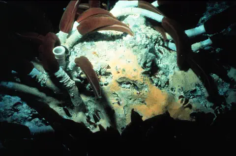
The giant tube worm lives more than a mile deep in the Pacific Ocean, beside hot springs in the seafloor called hydrothermal vents. It has no mouth and no stomach. Instead, billions of bacteria living inside its body make its food from chemicals in the vent water.
-
 Watch
Animal
Spectacled bear
The spectacled bear, or Andean bear, is the only bear that lives in South America. It is named for the pale markings that ring the eyes of many bears, like a pair of glasses. It lives in the forests of the Andes Mountains, climbs trees, builds platforms in branches and eats mostly fruit and bromeliads.
-
 Watch
Animal
Marine iguana
The marine iguana is the only lizard in the world that finds its food in the sea. It lives only on the rocky shores of the Galápagos Islands, where it grazes on seaweed, warms up on black lava rocks and sneezes out extra salt.
-
 Watch
Animal
Giant oceanic manta ray
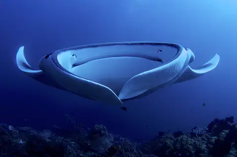
The giant oceanic manta ray is the largest ray in the world, with wing-like fins that can stretch more than 6 meters from tip to tip. This gentle filter feeder funnels plankton into its wide mouth, and it has a single pup only every two to three years.
Explore next
-
Watch
Natural wonder
Galápagos Islands
The Galápagos Islands are a group of volcanic islands in the Pacific Ocean, about 1,000 kilometers off the coast of Ecuador. Many of their animals live nowhere else on Earth, and they helped inspire Charles Darwin's theory of evolution by natural selection.
-
Watch
Animal
Santa Cruz giant tortoise
The Santa Cruz giant tortoise lives only on the western side of Santa Cruz Island in the Galápagos. It has a big, dome-shaped shell, eats grass, leaves and cactus, walks between the dry lowlands and the misty highlands, and can live for well over a century.
-
Watch
Animal
Blue-footed booby
The blue-footed booby is a seabird of the tropical eastern Pacific, from Mexico to Peru and the Galápagos Islands. Its bright blue feet star in its courtship dance: birds with bluer feet are more likely to find a mate. It catches fish by diving into the sea from high in the air.
-
Watch
Animal
Andean condor
The Andean condor is one of the largest flying birds in the world. With wings up to 3.2 meters across, it soars over the Andes Mountains of South America, barely flapping, as it searches for dead animals to eat. It is a vulture, nature's clean-up crew.
- Watch Geography The equator The Equator is an imaginary line around Earth's middle, halfway between the North and South Poles, at 0 degrees latitude. It splits Earth into the Northern and Southern Hemispheres. It is about 40,075 kilometers long and crosses countries such as Ecuador, Kenya, Gabon and Indonesia.
-
Watch
Animal
Giant tube worm
The giant tube worm lives more than a mile deep in the Pacific Ocean, beside hot springs in the seafloor called hydrothermal vents. It has no mouth and no stomach. Instead, billions of bacteria living inside its body make its food from chemicals in the vent water.
-
Watch
Animal
Spectacled bear
The spectacled bear, or Andean bear, is the only bear that lives in South America. It is named for the pale markings that ring the eyes of many bears, like a pair of glasses. It lives in the forests of the Andes Mountains, climbs trees, builds platforms in branches and eats mostly fruit and bromeliads.
-
Watch
Animal
Marine iguana
The marine iguana is the only lizard in the world that finds its food in the sea. It lives only on the rocky shores of the Galápagos Islands, where it grazes on seaweed, warms up on black lava rocks and sneezes out extra salt.
For parents & teachers
What children will learn
- Locate Ecuador, the equator, its neighbors and the Galápagos Islands.
- Describe Ecuador's four regions and how height changes the climate.
- Explain why Chimborazo's summit is the farthest point from Earth's center.
- Outline Ecuador's history from the Inca to independence in 1830.
Recommended ages: 3 to 17 · About 15 minutes
Talk about it
- How might life be different on the coast, in the high mountains and in the rainforest of the same country?
- Why do you think island animals, like the Galápagos tortoises, can be different from animals on the mainland?
- Ecuador uses the US dollar. Why might a country choose another country's money?
Try at home or in class
- Draw the equator on an orange with a marker, then find Ecuador on a globe and check that the line crosses it.
- Squash a soft ball gently from top and bottom and see how its middle bulges, like Earth at the equator.
Key vocabulary: equator, volcano, archipelago, evolution, mestizo, páramo, rainforest
Where these facts come from
- Wikidata , Wikimedia Foundation (CC0 1.0)
- Natural Earth vector data , Natural Earth (NACIS) (Public domain)
- UNESCO World Heritage List , UNESCO World Heritage Centre (Linked as a reference; site facts come from Wikidata)
- Ecuador (introduction, quick facts, land, relief, drainage, soils) , Encyclopaedia Britannica
- Ecuador: Climate (plant and animal life) , Encyclopaedia Britannica
- Ecuador: People (ethnic groups) , Encyclopaedia Britannica
- Ecuador: Daily life and social customs , Encyclopaedia Britannica
- Ecuador: Agriculture, forestry, and fishing , Encyclopaedia Britannica
- Ecuador: The colonial period (to 1830) , Encyclopaedia Britannica
- Ecuador: Modern history , Encyclopaedia Britannica
- What is the highest point on Earth as measured from Earth's center? , NOAA National Ocean Service
- Population, total: Ecuador , World Bank
- Galápagos Islands , UNESCO World Heritage Centre
- City of Quito , UNESCO World Heritage Centre
- Sangay National Park , UNESCO World Heritage Centre
- Historic Centre of Santa Ana de los Ríos de Cuenca , UNESCO World Heritage Centre
- PlayOwl region table, version 1 , PlayOwl (PlayOwl original data)
- flag-icons 7.5.0 , Panayiotis Lipiridis and contributors (MIT)
- Wikimedia Commons , Wikimedia Foundation (Per file (public domain, CC0, CC BY or CC BY-SA); see each media record)
Checked, not yet human-reviewed. Last updated October 27, 2026. Spotted a mistake? Tell us.
Picture credits
- Photo: Diego Delso, CC BY-SA 4.0, via Wikimedia Commons · source · license
- Photo: Eduardo Navas, CC BY-SA 2.0, via Wikimedia Commons · source · license
- Photo: Asamblea Nacional del Ecuador, CC BY-SA 2.0, via Wikimedia Commons · source · license
- Photo: camilogaleano.com, CC BY-SA 4.0, via Wikimedia Commons · source · license
- Photo: Don Johnston, CC0 1.0, via Wikimedia Commons · source · license
- Photo: Michel3ro, public domain, via Wikimedia Commons · source
- Photo: Dabit100 / David Torres Costales, CC BY-SA 3.0, via Wikimedia Commons · source · license
- Photo: E bailey, CC0 1.0, via Wikimedia Commons · source · license
- Photo: SantiagoGG, CC BY-SA 4.0, via Wikimedia Commons · source · license
- Photo: Charles J. Sharp, CC BY-SA 3.0, via Wikimedia Commons · source · license
- Photo: Murray Foubister, CC BY-SA 2.0, via Wikimedia Commons · source · license