
 Country
North America
El Salvador
El Salvador is a small country in Central America. It has a long line of volcanoes and a sunny Pacific coast. Farmers there grow coffee, corn and beans.
El Salvador is the smallest country on the mainland of Central America, and the only one without a Caribbean coast. A line of about 20 volcanoes crosses its middle, and rich volcanic soil has fed farms for centuries. The 2024 census counted 6,029,976 people, and most live in cities in the central highlands.
El Salvador, the smallest and most densely populated country in Central America, lies wholly on the Pacific side of the isthmus within the Central American volcanic arc. Once the Pipil land of Cuscatlán, it became a Spanish province, joined the Central American federation and took its present name in 1841. After a civil war ended with UN-mediated peace accords in 1992, its economy shifted from coffee toward services, manufacturing and remittances. The 2024 census counted 6,029,976 people.
Photo: randreu, CC BY 3.0, via Wikimedia Commons
Discover El Salvador
El Salvador is a country in Central America.
It is small, with many volcanoes. The Pacific Ocean is on one side. The capital city is San Salvador.
El Salvador is in Central America, the narrow strip of land between Mexico and South America. It is the smallest country on the mainland there, and the only one with no coast on the Caribbean Sea: its only coast faces the Pacific Ocean.
In 2024 the national census counted 6,029,976 people, so El Salvador is also the most crowded country in Central America. Spanish is the official language, and the capital is San Salvador. El Salvador uses the U.S. dollar as its money.
Britannica calls El Salvador the smallest and most densely populated country in Central America, a land of quickly shifting terrain of volcanoes, fertile valleys and Pacific shores. Its whole territory lies on the western side of the isthmus, so it alone in Central America lacks a Caribbean coast.
The VII Population Census of 2024, presented by the Central Reserve Bank (BCR), counted 6,029,976 people, 52.8% of them women, an increase of about 5% (285,863 people) over the 5,744,113 of 2007. The department of San Salvador holds 29.4% of the population. The U.S. dollar has been legal tender since January 1, 2001. El Salvador is a republic with a 60-seat Legislative Assembly; Nayib Bukele is president.
Cities in the volcano valleys
San Salvador is the biggest city.
It sits in a valley near a volcano. Santa Ana has a grand old theater. Long ago, ash covered a farming village called Joya de Cerén.
Most Salvadorans live in the valleys between the volcanoes, where the soil is rich. San Salvador, the capital, has grown so much that it now runs all the way from Nueva San Salvador to Lake Ilopango, and about one in four Salvadorans lives in this big city area.
Santa Ana is the busy center of the west; the photo shows its theater beside its cathedral. San Miguel, in the east, sits on the slope of the San Miguel volcano. Near San Salvador lies Joya de Cerén, a farming village buried by a volcano's ash around the year 600.
More than three-fourths of Salvadorans live in the intermontane basins of the central highlands, where Indigenous communities farmed corn, beans and squash for millennia; ruins at Chalchuapa, Sihuatán and Cara Sucia are their legacy. Spanish colonial towns grew there too, and the San Salvador conurbation now stretches from Nueva San Salvador to Lake Ilopango and holds about one-fourth of the population. Santa Ana is the commercial center of the west, and San Miguel mixes colonial and modern architecture on its volcano's slope.
UNESCO's Joya de Cerén (inscribed 1993) was a pre-Hispanic farming community buried by an eruption of the Laguna Caldera volcano about AD 600. Like Pompeii and Herculaneum, its exceptionally preserved remains show the daily life of Central American farmers of the time. Most of these cities have suffered one or more destructive earthquakes.

A land of volcanoes
A long line of volcanoes crosses the country.
Some of them are still active. Heavy rain falls from May to October. The rest of the year is dry.
El Salvador lies on the Central American volcanic arc, one of the most active volcano zones in the Americas. About 20 volcanoes march across the middle of the country from west to east, from Izalco to Conchagua. Between them are high valleys with soil made from ash and lava, perfect for crops.
The weather is warm rather than hot in the highlands. Heavy rains called temporales fall from May to October, and November to April is dry. Pine-oak and cloud forests grow in the high mountains, dry tropical forest lower down, and mangroves line parts of the coast.
The central highlands carry a west-east line of 20 volcanic cones, some active: Izalco (1,965 m), San Salvador (1,960 m), San Miguel (2,130 m) and Conchagua (1,243 m) in the far east. Between them, basins at 1,000–1,500 m have fertile soils of volcanic ash, lava and alluvium. North of them the Lempa River drains a broad interior plain, and an older, eroded volcanic range runs along the northern border, where steep slopes, forest clearance and overused soils have badly degraded the land. Cerro El Pital, about 2,730 m (Wikidata), is the highest point.
The climate is tropical, moderated by elevation. San Salvador, at 682 m, ranges from a mean of about 17 °C in January to 34 °C maximum in March. The Pacific lowlands receive about 1,700 mm of rain a year, falling mostly in the May–October temporales. Vegetation runs from pine-oak and cloud forests to tropical dry forest and coastal mangroves; the maquilishuat is the national tree and the izote the national flower.
Wildlife of mountains and coast
Monkeys, deer and armadillos live here.
Crocodiles rest in coastal wetlands. Sea turtles lay eggs on the beaches. Hundreds of kinds of birds fly here.
Even though El Salvador is small, it has monkeys, deer, armadillos, coyotes, reptiles, amphibians and hundreds of kinds of birds. American crocodiles live in some coastal wetlands and river mouths, and sea turtles nest on parts of the Pacific coast.
People have cut down a lot of forest over the centuries for farms and cities. National parks and protected areas now help keep homes for wild animals.
Britannica lists monkeys, deer, armadillos, coyotes, reptiles, amphibians and hundreds of bird species; American crocodiles live in some coastal wetlands and estuaries, and sea turtles nest on parts of the Pacific coast. El Salvador also lies inside the IUCN-mapped native ranges of the green and hawksbill sea turtles, the ocelot, puma, raccoon and resplendent quetzal, while the scarlet macaw and harpy eagle are mapped as historical, no longer present.
Centuries of deforestation, agricultural expansion and urbanization have shrunk natural habitats, which makes the remaining national parks and protected areas important for conserving biodiversity. The photos on this page were taken in other countries.

People, coffee and life abroad
About six million people live in El Salvador.
Most people speak Spanish. Many live in cities. Some families have relatives in other countries.
Most Salvadorans have both Indigenous and Spanish ancestors. Long ago, many Indigenous languages were spoken, such as Nahuatl in the center, but today Spanish is the language almost everyone uses. Nearly three out of four people live in towns and cities.
For more than a century, coffee grown on the volcano slopes was the country's main product. Today many people work in services and factories. Many Salvadorans have moved to other countries, especially the United States, and the money they send home to their families is important.
Almost nine-tenths of Salvadorans are mestizo; the rest include Indigenous peoples (among them the Izalco and the Pancho of Panchimalco), people of European ancestry and small other groups. Nahuatl and Poton were the main precolonial languages; Spanish became official, and a government effort to preserve Nahuatl did not succeed. About half the population is Roman Catholic, which has special recognition in the constitution, and by the 2010s more than one-third were Protestant.
From the 19th century the highland basins were ideal for coffee, the base of the economy. During the civil war about one-fifth of the population is estimated to have left, in roughly equal numbers for neighboring countries and the United States, and most have not returned. Britannica describes today's economy as driven largely by services, manufacturing and remittances from Salvadorans abroad.
From Cuscatlán to today
The Pipil people lived here long ago.
Then Spanish soldiers came and built towns. In 1821 the land became free from Spain. Later it took the name El Salvador.
Before the Spanish came, the Pipil people lived in much of El Salvador and called their main town Cuscatlán, which means Land of the Jewel. Spanish soldiers arrived in 1524, and San Salvador was founded nearby. For about 300 years Spain ruled, and farmers grew cocoa and later indigo, a plant used to make blue dye.
In 1821 the region became independent from Spain, then joined a union of Central American states. It took the name El Salvador in 1841. A long civil war, from the late 1970s to the early 1990s, ended with peace agreements in 1992, and the country then rebuilt.
The Pipil, a Nahua-speaking people, held much of western and central El Salvador, with their principal settlement at Cuscatlán. Pedro de Alvarado's expedition arrived from Guatemala in 1524 and met determined Pipil resistance; San Salvador, founded in 1525, was permanently established in 1528. Cocoa, then indigo, made the region the agricultural heartland of the captaincy general of Guatemala, while burdening Indigenous workers.
The province endorsed independence from Spain in 1821, opposed annexation to Mexico, and was a leading state of the Central American federation; the name El Salvador dates from 1841. Coffee later dominated, and decades of military-dominated rule and deep inequality led to a civil war between a left-wing insurgency and the U.S.-backed armed forces, ended by UN-mediated accords in 1992. Earthquakes in 2001, emigration and gang violence followed; anti-gang campaigns since the early 2020s have sharply cut homicides, Britannica notes, while drawing scrutiny over civil liberties and human rights.
El Salvador on the map
Find El Salvador on the globe.
Look at the thin land between North and South America. El Salvador is a small country by the Pacific Ocean.
El Salvador is in Central America. Guatemala is to the northwest, Honduras is to the north and east, and the Pacific Ocean is to the south.
It is the only Central American country with no Caribbean coast: its one coast is on the Pacific. Its biggest river, the Lempa, flows across the country into the Pacific.
Britannica bounds El Salvador by Honduras to the north and east, the Pacific to the south and Guatemala to the northwest; Britannica gives an area of 21,040 km², close to the 21,041 km² on Wikidata. The whole country lies within the Central American volcanic arc.
The central highlands' volcanic chain and basins form the core where most people live, with a narrow Pacific coastal plain at 30–150 m to the south and the Lempa's interior plain and the northern highlands beyond.
- Volcanic cones in the central chain
- 20
- San Salvador elevation
- 682 m
- People (2024 census)
- 6,029,976
- Joya de Cerén buried
- about AD 600
Amazing facts
-
A whole farming village was buried by volcanic ash about 1,400 years ago.
Around the year 600, ash from the Laguna Caldera volcano buried the farming village of Joya de Cerén, keeping it so well that we can see how its people lived.
UNESCO compares Joya de Cerén, buried by Laguna Caldera about AD 600, with Pompeii and Herculaneum for the insight its preserved remains give into everyday farming life.
-
El Salvador has a beach on only one ocean.
El Salvador is the only country in Central America with no coast on the Caribbean Sea.
Lying wholly on the western side of the isthmus, El Salvador is the only Central American country that lacks a Caribbean coast.
-
Long ago, the Pipil people's main town was called Land of the Jewel.
The Pipil people called their main settlement Cuscatlán, which means Land of the Jewel.
Cuscatlán ('Land of the Jewel') was the principal settlement of the Pipil, a Nahua-speaking people who held much of western and central El Salvador before the Spanish conquest; San Salvador was founded near its site.
-
El Salvador uses the same money as the United States.
Since 2001, El Salvador's money has been the U.S. dollar.
The U.S. dollar has been legal tender in El Salvador since January 1, 2001.
Words to know
- volcanic arc
- a long curved chain of volcanoes formed where one piece of Earth's crust slides under another
- isthmus
- a narrow strip of land that joins two larger pieces of land
- indigo
- a plant used to make a deep blue dye
- census
- an official count of all the people in a country
- remittance
- money that people working in another country send home to their families
- mestizo
- a person with both Indigenous American and European ancestors
Discovery challenge
-
What kind of mountains cross El Salvador?
What makes up the long line of about 20 mountains across El Salvador?
The central highlands carry a west-east chain of 20 cones of what kind?
- Volcanoes
- Glaciers
- Sand dunes
Show the answer
Volcanoes
They are volcanoes.
About 20 volcanoes, some still active, cross the middle of the country.
They are volcanic cones, from Izalco in the west to Conchagua in the east.
-
Which ocean is next to El Salvador?
El Salvador has a coast on which ocean only?
On which ocean is El Salvador's only coastline?
- The Atlantic
- The Pacific
- The Indian
Show the answer
The Pacific
The Pacific Ocean is next to El Salvador.
Its only coast faces the Pacific, so it has no Caribbean coast.
It lies wholly on the Pacific side of the isthmus.
-
What covered the village of Joya de Cerén long ago?
What buried the farming village of Joya de Cerén around the year 600?
What preserved Joya de Cerén about AD 600?
- Snow
- A flood of mud from the sea
- Ash from a volcano
Show the answer
Ash from a volcano
Ash from a volcano covered it.
An eruption of the Laguna Caldera volcano buried it in ash.
An eruption of Laguna Caldera buried and preserved it, as at Pompeii.
-
What is the capital city of El Salvador?
Which city, founded by the Spanish near Cuscatlán, is the capital?
Which capital, permanently established in 1528, now anchors a conurbation of about one-fourth of the population?
- San Salvador
- Santa Ana
- San Miguel
Show the answer
San Salvador
San Salvador is the capital.
San Salvador is the capital. Santa Ana and San Miguel are other big cities.
San Salvador, founded in 1525 and permanent from 1528, is the capital.
Places to discover in El Salvador
Animals of El Salvador
-
Watch
Animal
American crocodile
The American crocodile is a large reptile of warm coasts and mangrove swamps, from the southern tip of Florida through Mexico, Central America, the Caribbean and northern South America. It is shy, it basks in the sun to warm up, and mother crocodiles carry their babies to the water.
-
 Watch
Animal
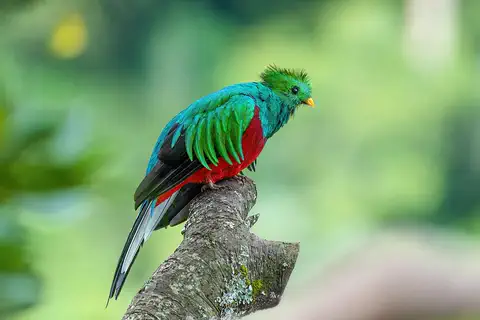
Resplendent quetzal
The resplendent quetzal is a glittering green and red bird of the cloud forests of southern Mexico and Central America. Males grow long, flowing plumes, up to about 90 centimeters. Quetzals eat mostly small fruits related to avocados, and the bird is the national emblem of Guatemala.
Explore next
-
Watch
City
San Salvador
San Salvador is the capital of El Salvador, in Central America. It lies 682 meters up on a volcanic plateau, about 25 kilometers from the Pacific Ocean, with the San Salvador volcano to the northwest. At the 2024 census, 329,379 people lived in the city.
-
 Watch
 Country
Guatemala
Guatemala lies between Mexico and the rest of Central America. A row of 27 volcanoes crosses its south, and the great Maya city of Tikal rises from the rainforest of the north. About two-fifths of its people are Maya, more than 20 Mayan languages are spoken, and colorful handwoven clothes are still worn in many villages.
-
 Watch
 Country
Honduras
Honduras is a mountainous country in Central America, with the Caribbean Sea to the north and a short Pacific coast to the south. Its forests are home to jaguars and macaws, the Maya city of Copán stands in the west, and about 10.2 million people live there (official 2026 estimate).
-
Watch
Animal
American crocodile
The American crocodile is a large reptile of warm coasts and mangrove swamps, from the southern tip of Florida through Mexico, Central America, the Caribbean and northern South America. It is shy, it basks in the sun to warm up, and mother crocodiles carry their babies to the water.
-
Watch
Animal
Resplendent quetzal
The resplendent quetzal is a glittering green and red bird of the cloud forests of southern Mexico and Central America. Males grow long, flowing plumes, up to about 90 centimeters. Quetzals eat mostly small fruits related to avocados, and the bird is the national emblem of Guatemala.
- Watch Geography Types of volcanoes Volcanoes come in different shapes. Runny lava builds wide, gentle shield volcanoes like Mauna Loa. Sticky lava and ash build tall, steep stratovolcanoes like Mount Fuji. Small cinder cones grow from bits of lava thrown into the air. Whether lava is runny or sticky, and how much gas it holds, decides the shape and how explosive the eruptions are.
-
 Watch
 Country
United States
The United States is a large country in North America made of 50 states, from icy Alaska to the warm islands of Hawaii. It has the Grand Canyon, the Mississippi River and Yellowstone, and about 342 million people live there.
-
 Watch
 Country
Mexico
Mexico is a large country in southern North America, between the Pacific Ocean and the Gulf of Mexico. It has smoking volcanoes, ancient cities built by the Maya and other peoples, and about 132 million people, many of them in and around Mexico City.
For parents & teachers
What children will learn
- Locate El Salvador and explain why it has only a Pacific coast.
- Explain how a chain of volcanoes made El Salvador's valleys fertile and its cities prone to earthquakes.
- Describe what Joya de Cerén shows about everyday farming life about AD 600.
- Outline El Salvador's history from the Pipil and Spanish rule to independence and the 1992 peace accords.
Recommended ages: 3 to 17 · About 15 minutes
Talk about it
- Why do you think so many people live in the valleys between volcanoes, even though volcanoes can be dangerous?
- What could a village buried in ash tell us that written history might not?
- How might families stay close when some members live in another country?
Try at home or in class
- Mix potting soil with a little sand and ash-like gray clay dust (or crushed chalk) and plant a few bean seeds in it and in plain sand; compare which grow better over two weeks.
- Draw a cross-section of a volcano and label the crater, magma chamber and layers of ash.
Key vocabulary: volcanic arc, isthmus, indigo, census, remittance, mestizo
Where these facts come from
- Wikidata , Wikimedia Foundation (CC0 1.0)
- Natural Earth vector data , Natural Earth (NACIS) (Public domain)
- UNESCO World Heritage List , UNESCO World Heritage Centre (Linked as a reference; site facts come from Wikidata)
- El Salvador (introduction, quick facts, land, landscape, climate) , Encyclopaedia Britannica
- El Salvador: Plant and animal life (also people, languages, religion, settlement, demographic trends) , Encyclopaedia Britannica
- El Salvador: The colonial period (conquest, independence, federation) , Encyclopaedia Britannica
- Joya de Cerén Archaeological Site , UNESCO World Heritage Centre
- El Salvador tiene más de 6.02 millones de habitantes, 5% más que hace 17 años, según censo de población (BCR results of the 2024 census) , Diario El Mundo
- PlayOwl region table, version 1 , PlayOwl (PlayOwl original data)
- flag-icons 7.5.0 , Panayiotis Lipiridis and contributors (MIT)
- Wikimedia Commons , Wikimedia Foundation (Per file (public domain, CC0, CC BY or CC BY-SA); see each media record)
Checked, not yet human-reviewed. Last updated November 1, 2026. Spotted a mistake? Tell us.
Picture credits
- Photo: randreu, CC BY 3.0, via Wikimedia Commons · source · license
- Photo: Mariordo (Mario Roberto Durán Ortiz), CC BY-SA 3.0, via Wikimedia Commons · source · license
- Photo: Tomás Castelazo, CC BY-SA 2.5, via Wikimedia Commons · source · license
- Photo: Charles J. Sharp, CC BY-SA 4.0, via Wikimedia Commons · source · license
- Photo: © Giles Laurent, gileslaurent.com, License CC BY-SA, CC BY-SA 4.0, via Wikimedia Commons · source · license