
 Country
Africa
Ghana
Ghana is a country in West Africa, by the sea. It has rainforests, a giant lake and colorful kente cloth.
Ghana is a country in West Africa on the Gulf of Guinea. It has a coast of sandy bays, a belt of rainforest and wide northern savannas, and one of the world's largest artificial lakes, Lake Volta. In 1957 it became independent, and its capital is Accra.
Ghana, on the Gulf of Guinea, is a low-lying country of coastal savanna, forest and northern savanna dominated by the Volta basin. Once the British Gold Coast, it became on 6 March 1957 the first black African country south of the Sahara to achieve independence from colonial rule. The Ghana Statistical Service counted 30.8 million people in its 2021 census and projects about 34.4 million for 2026.
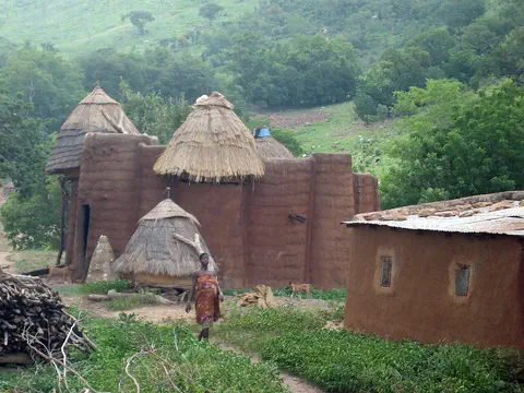
Photo: Goldenwabbit, CC BY-SA 4.0, via Wikimedia Commons
Discover Ghana
Ghana is a country in West Africa.
Its south side touches the ocean. It has sandy beaches, green forests and grassy plains. The capital city is Accra.
Ghana is in West Africa, on the coast of the Gulf of Guinea, part of the Atlantic Ocean. Burkina Faso is to the north, Togo to the east and Côte d'Ivoire to the west.
Ghana has three main kinds of land: a coastal savanna in the southeast, a zone of thick forest across the south, and wide grassy savanna that covers the northern two-thirds of the country. Most of the land is low. The Ghana Statistical Service projects that about 34.4 million people live in Ghana in 2026, and the capital, Accra, is on the coast.
Ghana lies on the Gulf of Guinea in western Africa, bordered by Burkina Faso to the northwest and north, Togo to the east and Côte d'Ivoire to the west. Relief is generally low, nowhere above about 900 meters, and the country is dominated by the Volta River basin, now filled in its center by Lake Volta.
Britannica describes three regions: a small coastal zone with more towns than any other, a forest region covering about one-third of the land with much of the country's farming, timber and mineral wealth, and the northern savanna, about two-thirds of the area. The 2021 census counted 30,832,019 people, five times the 1960 total, and the Ghana Statistical Service projects 34,378,768 for 2026. Britannica calls Ghana the first black African country south of the Sahara to achieve independence from colonial rule, in 1957.
Cities, castles and a giant lake
Accra is the capital of Ghana.
It is a big city by the sea. Kumasi is a big city in the forest. Old stone castles stand along the coast.
Accra, the capital and largest city, stands partly on a low cliff above the Gulf of Guinea and spreads north across the Accra plains. It grew from several Ga settlements into a trading hub and became the capital of the British Gold Coast colony in 1877. Kumasi, in the forest of south-central Ghana, was the capital of the Asante kingdom and is known as the Garden City of West Africa.
Along about 500 kilometers of coast stand old forts and castles built by European traders from 1482 onward. Together they are a World Heritage Site. In the east, the Akosombo Dam, finished in 1965, holds back Lake Volta, about 400 kilometers long.
Accra lies partly on a cliff 8 to 12 m high and became capital of the Gold Coast colony in 1877 and of independent Ghana in 1957. Kumasi, set among forested hills, was chosen as his capital by Osei Tutu, a 17th-century Asante king; Britannica says it is still the seat of the Asantehene and of the Golden Stool, the symbol of royal authority and unity. Northeast of Kumasi, Asante traditional buildings of timber, bamboo and mud plaster, decorated with bold reliefs of spirals, animals, birds and plants, were inscribed by UNESCO in 1980 as the last surviving examples of a style of the late 18th to late 19th centuries; some are still used as places of worship.
UNESCO's forts and castles (1979) span about 500 km between Keta and Beyin and were built between 1482 and 1786 by traders from Portugal, Spain, Denmark, Sweden, Holland, Germany and Britain; St. George's d'Elmina Castle (1482) is one of the oldest European buildings outside Europe. At the port of Tema, the Greenwich Meridian crosses the country. The Akosombo Dam, begun in 1961 and completed in 1965, created Lake Volta, which covers about 8,502 km²; its construction flooded 740 villages and resettled 78,000 people.
Forest, savanna and the harmattan
Ghana is warm all year.
In the south, thick green forest grows. In the north, there are grassy plains with baobab trees. A hot, dry wind blows from the desert from December to February.
Ghana is warm all year, with average temperatures of about 26 to 29 °C. The south has two rainy seasons, from April to July and from September to November, and a forest of tall trees such as mahogany and silk cotton. The north has a single wet season that peaks in August and September, and grassland with shea butter trees, acacias and baobabs.
From about December to February, a hot, dry wind called the harmattan blows from the Sahara. Ghana's highest point, Mount Afadjato, is only 885 meters high, in hills near the border with Togo. South of Kumasi lies Lake Bosumtwi, Ghana's only true natural lake, which fills a crater made by a meteorite.
Ghana's climate is set by two air masses: hot, dry continental air from the Sahara, carried south by the northeast trade winds known as the harmattan, and humid maritime air from the South Atlantic. Rain falls when maritime air dominates. The northern savanna has one wet season peaking in August and September and 1,020 to 1,400 mm a year; the southern forest has two rainy seasons and about 1,270 to 2,180 mm. Mean annual temperatures are 26 to 29 °C.
Much of the north-center is the Voltaian Basin of Paleozoic shales and sandstones, rarely above 150 m, bordered by scarps such as the Kwahu and Gambaga. Along the eastern edge, the Akwapim-Togo Ranges hold the highest points, including Mount Afadjato (885 m), Mount Djebobo (876 m) and Mount Torogbani (872 m). The Black Volta, White Volta and Oti drain into the Volta system, while the Pra, Ankobra and Tano flow straight to the sea. Lake Bosumtwi, south of Kumasi, lies in a meteorite impact crater with no outlet to the sea.
Animals of Ghana
Elephants live in Ghana's wild parks.
Chimpanzees and many kinds of monkeys live in Ghana too. Hippos swim in the Volta River. Parrots and hornbills fly in the trees.
Ghana's large animals include lions, leopards, hyenas, antelope, elephants, buffalo, chimpanzees and many kinds of monkeys. Crocodiles, otters and endangered manatees live in the rivers and lagoons, and hippopotamuses live in the Volta River. Birds include parrots, hornbills, kingfishers, eagles and herons.
Mole National Park, in the north, covers about 4,900 square kilometers and has elephants, monkeys and crocodiles. Kakum National Park, about 22 kilometers north of Cape Coast, protects about 360 square kilometers of rainforest. It opened to the public in 1994 and is home to many endangered mammals, reptiles, birds and butterflies.
Britannica describes Ghana as relatively rich in animal life, though reduced by hunting and the spread of settlement. Large mammals include lions, leopards, hyenas, antelope, elephants, buffalo, wild hogs, chimpanzees and many monkeys; snakes include pythons, cobras, puff adders and green mambas. Crocodiles, otters and the endangered manatee inhabit rivers and lagoons, and hippopotamuses the Volta. Birds range from parrots and hornbills to sunbirds, nightjars, vultures and plantain-eaters.
Vegetation follows rainfall: coastal savanna of Guinea grass and thickets around Accra, with giant anthills 3 to 4 m high; evergreen and semi-deciduous forest across the southern third, with emergent silk cotton, wawa and African mahogany trees; and northern savanna with shea butter trees, acacias and baobabs. Mole National Park near Damongo (about 4,900 km²) holds elephants, monkeys and crocodiles. Kakum National Park, about 360 km² of rainforest, was set up as a timber reserve in 1932 and opened to the public in 1994. Sardines, locally called herring, arrive in large seasonal shoals off the coast.
People, languages and food
Many different peoples live in Ghana.
They speak many languages, and English too. Kente is a bright cloth woven by hand. Fufu is made by pounding boiled yams, cassava or plantains.
Ghana is home to many peoples. The largest groups are the Akan, which include the Asante and the Fante, the Mole-Dagbani, the Ewe, the Ga-Adangme and the Gurma, and at least 75 language groups can be told apart. English is the official language. More than half of the people are Christian, about one-fifth are Muslim, and a small number follow traditional religions.
Ghanaian food includes fufu, pounded balls of cassava, yams or plantains, kenke made from fermented cornmeal, groundnut soup, palm nut soup and jollof rice. Kente, a richly colored cloth woven by hand, is made by the Akan and Ewe; the village of Bonwire near Kumasi is famous for it. Highlife music has been popular since the 1930s.
Britannica distinguishes at least 75 language-based subgroups, of which about 10 are numerically significant; the largest are the Akan (including Asante, Fante and Guang), Mole-Dagbani, Ewe, Ga-Adangme and Gurma. English, the official language, has helped play down ethnic differences in public life. More than half the population is Christian, mostly in the south, about one-fifth Muslim, strongest in the far north and larger towns, and a small segment follows indigenous religions. About three-fifths of people lived in towns in the 2020s, and the 2021 census found Greater Accra (17.7 percent) and Ashanti (17.6 percent) the most populous regions.
Cuisine includes fufu, kenke (fermented cornmeal wrapped in plantain leaves or corn husks), groundnut and palm nut soups, waakye of rice and beans cooked with sorghum leaves, and jollof rice. Kente, the handwoven cloth of the Akan and Ewe, is made in craft villages such as Bonwire near Kumasi, and Ntonso is known for Adinkra cloth. Highlife, which blended European dance steps with local rhythms, spread from the 1930s. Independence Day is celebrated on 6 March.

From the Gold Coast to Ghana
Long ago, kingdoms grew in Ghana's forests.
The Asante kingdom had its capital at Kumasi. Traders came by ship and built stone castles. In 1957, Ghana became a free country.
Ghana is named after a great trading empire of long ago, which lay far to the northwest. In 1471 Portuguese sailors reached the coast, and Europeans came to trade for gold, so the land became known as the Gold Coast. The Portuguese built the first stone castle, Elmina, in 1482. From the 1600s the forts also became part of the slave trade, in which enslaved people were shipped across the ocean.
Inland, the Asante built a powerful kingdom around Kumasi. Britain took control in the late 1800s, and by the 1920s farmers in the Gold Coast grew more than half of the world's cocoa. Led by Kwame Nkrumah, the colony became the independent country of Ghana on March 6, 1957.
Ghana takes its name from a medieval empire centered about 800 km to the northwest, which Britannica says probably included no part of the modern state. Portuguese mariners arrived in 1471, trading for gold; Elmina Castle (1482) was the first of the stone forts. In the 17th century Dutch, English, Danish, Swedish and Prussian traders turned the coastal trade toward the export of enslaved people; UNESCO notes the forts' significant part in the slave trade and, in the 19th century, in its suppression, after the Danes, English and Dutch outlawed their slave trades between 1803 and 1814. From the late 17th century the Asante states united around Kumasi into an empire that lasted into the late 19th century; Britain conquered Asante in 1896 to 1901.
Cacao, introduced in the 1870s, made the Gold Coast the source of more than half the world's cocoa by the 1920s. Kwame Nkrumah's Convention People's Party campaigned for 'self-government now', and on 6 March 1957 Ghana became independent; it became a republic in 1960. After periods of military rule from 1966, presidential elections resumed in 1992, and in 2001 power passed peacefully between democratically elected governments for the first time since independence.
Ghana on the map
Find Ghana on the globe.
It is in West Africa, by the ocean. The line for zero longitude goes right through Ghana. A big blue lake fills the middle of the country.
Ghana is in West Africa, on the Gulf of Guinea. Burkina Faso is to the north, Togo to the east and Côte d'Ivoire to the west. The Greenwich Meridian, the line of zero longitude, passes through Ghana at the port city of Tema.
Look for the long blue shape of Lake Volta, which stretches about 400 kilometers through the middle of the country, from the Akosombo Dam north to Yapei. The coastline is low, with sandy bays and rocky points.
Ghana is bordered by Burkina Faso to the northwest and north, Togo to the east, the Atlantic Ocean (Gulf of Guinea) to the south and Côte d'Ivoire to the west. The Greenwich Meridian crosses it at Tema, where a monument called the Meridian Rock was set up at the port in 2014; the Ghana News Agency reported in 2021 that it had been removed when the port expanded.
Lake Volta, about 400 km long, extends from the Akosombo Dam, just south of Ajena, upstream to Yapei beyond the former confluence of the Black and White Volta. Britannica gives its area as about 8,502 km², or 3.6 percent of Ghana. The lake is navigable, linking the northern savanna with the coast. The Akwapim-Togo Ranges run northeast to southwest from the Togo border to the sea just west of Accra, and the wide, lagoon-fringed Volta delta lies about 80 km east of Accra.
- Neighbors
- Burkina Faso (north), Togo (east), Côte d'Ivoire (west)
- Lake Volta
- about 400 km long, about 8,502 km²
- Highest point
- Mount Afadjato, 885 m
- Greenwich Meridian
- crosses Ghana at Tema
Amazing facts
-
The zero line for longitude goes through Ghana.
The Greenwich Meridian, the line of zero longitude, passes through Ghana at the port city of Tema.
The Greenwich Meridian crosses Ghana at Tema, where a monument called the Meridian Rock stood at the port from 2014 until it was removed when the port expanded.
-
One lake in Ghana fills a giant hole made by a space rock.
Lake Bosumtwi, south of Kumasi, is Ghana's only true natural lake, and it lies in a crater made by a meteorite.
Lake Bosumtwi, Ghana's only true natural lake, occupies a meteorite impact crater and has no outlet to the sea.
-
Lake Volta was made by people, with a dam.
Lake Volta formed behind the Akosombo Dam, finished in 1965, and it is one of the largest artificial lakes in the world.
With a storage capacity of about 153 billion cubic meters, Lake Volta is one of the world's largest artificial lakes, covering about 3.6 percent of Ghana.
-
Some anthills in Ghana are taller than a grown-up.
On the coastal savanna around Accra, giant anthills can be 3 to 4 meters high, with clumps of bushes growing on them.
Giant anthills, often 3 to 4 m high, anchor thicket clumps, including baobabs, on the coastal savanna around Accra.
-
Long ago, Ghana grew more than half of the world's cocoa.
By the 1920s, farmers in the Gold Coast were growing more than half of the world's cocoa, the beans used to make chocolate.
Cacao was introduced in the 1870s; by the 1920s the Gold Coast was producing more than half of the world's supply of cocoa.
Words to know
- savanna
- a wide grassland with scattered trees
- harmattan
- a hot, dry wind that blows from the Sahara over West Africa
- dam
- a strong wall built across a river to hold back water
- kente
- a richly colored cloth woven by hand, made by the Akan and Ewe
- colony
- a land ruled by another country far away
- independence
- when a country rules itself
- meridian
- a line on a map or globe running from the North Pole to the South Pole
Discovery challenge
-
What is the capital city of Ghana?
Which coastal city is the capital of Ghana?
Which city became capital of the Gold Coast colony in 1877 and is Ghana's capital today?
- Kumasi
- Accra
- Tamale
Show the answer
Accra
Accra is the capital. It is by the sea.
Accra, on the Gulf of Guinea, is the capital and largest city.
Accra became the Gold Coast's capital in 1877 and the capital of independent Ghana in 1957.
-
In which year did Ghana become a free country?
In which year did Ghana become independent?
In which year did the Gold Coast become independent as Ghana, led by Kwame Nkrumah?
- 1957
- 1801
- 2001
Show the answer
1957
Ghana became free to rule itself in 1957.
Ghana became independent on March 6, 1957. Kwame Nkrumah led the way.
On 6 March 1957 the Gold Coast became independent as Ghana, the first black African country south of the Sahara to achieve independence from colonial rule.
-
What made the giant Lake Volta?
What made Lake Volta, one of the world's biggest artificial lakes?
Lake Volta is an artificial lake. What created it?
- A volcano
- A glacier
- A dam across a river
Show the answer
A dam across a river
A big dam holds back the river and made the lake.
The Akosombo Dam, finished in 1965, holds back the Volta River and formed Lake Volta.
The Akosombo Dam, begun in 1961 and completed in 1965, dammed the Volta just south of Ajena, creating a lake about 400 km long.
-
What is kente?
What is kente, made near Kumasi?
Kente, made by the Akan and Ewe, is what kind of craft?
- A colorful cloth woven by hand
- A kind of fish
- A tall mountain
Show the answer
A colorful cloth woven by hand
Kente is a bright cloth woven by hand.
Kente is a richly colored handwoven cloth; the village of Bonwire near Kumasi is famous for it.
Kente is the richly colored handwoven cloth of the Akan and Ewe, made in craft villages such as Bonwire.
-
Long ago, what was Ghana called?
Before 1957, what was Ghana called?
Which name, from the gold European traders sought, did the colony carry until 1957?
- The Coral Coast
- The Gold Coast
- The Silver Coast
Show the answer
The Gold Coast
It was called the Gold Coast.
Europeans came to trade for gold, so the land was called the Gold Coast.
Gold, readily available on the coast, gave the country the name Gold Coast, used until 1957.
Animals of Ghana
-
 Watch
Animal
Common hippopotamus
The common hippopotamus is one of the biggest animals on land, yet it spends most of the day resting in rivers and lakes to keep cool. At night it walks out to graze, and its special skin makes its own sunscreen.
-
 Watch
Animal
Emperor scorpion
The emperor scorpion is one of the biggest scorpions in the world, up to about 20 centimeters long. It lives in the warm, humid forests of West Africa, where it digs burrows and hunts insects such as termites at night. Mothers give birth to live young and carry them on their backs. Like other scorpions, it glows blue-green under ultraviolet light.
-
 Watch
Animal
Gray parrot
The gray parrot is a gray, red-tailed parrot from the rainforests of West and Central Africa. It lives in big, noisy flocks, eats fruit and seeds, and is famous for copying sounds. Trapping for the pet trade and forest loss have made it endangered.
Explore next
-
Watch
Animal
Common hippopotamus
The common hippopotamus is one of the biggest animals on land, yet it spends most of the day resting in rivers and lakes to keep cool. At night it walks out to graze, and its special skin makes its own sunscreen.
-
Watch
Animal
Emperor scorpion
The emperor scorpion is one of the biggest scorpions in the world, up to about 20 centimeters long. It lives in the warm, humid forests of West Africa, where it digs burrows and hunts insects such as termites at night. Mothers give birth to live young and carry them on their backs. Like other scorpions, it glows blue-green under ultraviolet light.
-
Watch
Animal
Gray parrot
The gray parrot is a gray, red-tailed parrot from the rainforests of West and Central Africa. It lives in big, noisy flocks, eats fruit and seeds, and is famous for copying sounds. Trapping for the pet trade and forest loss have made it endangered.
-
 Watch
 Country
Burkina Faso
Burkina Faso is a landlocked country in West Africa, on a wide plateau of savanna that is grassy in the north and dotted with forest in the south. About 24 million people live there. Its name, chosen in 1984, means Land of Incorruptible People, and its capital is Ouagadougou.
-
 Watch
 Country
Togo
Togo is a small, narrow country in West Africa. It has only 51 kilometers of coast on the Gulf of Guinea but stretches about 515 kilometers inland, from beaches and lagoons to the Togo Mountains and northern savanna. About 8.6 million people lived there in 2025, and Lomé is the capital and main port.
- Watch Geography Where our food grows Where a crop can grow depends on climate, soil and water. Rice needs warm weather, wheat can sprout in the cool, and cocoa for chocolate grows only in a hot, rainy belt near the Equator. An FAO atlas from 1995 found that just three crops, rice, maize and wheat, gave the world most of its food energy.
-
 Watch
 Country
Democratic Republic of the Congo
The Democratic Republic of the Congo, or DR Congo, is the second-largest country in Africa. The mighty Congo River curves through its rainforests, volcanoes rise in the east, and its capital, Kinshasa, is a center of music, fashion and popular culture.
-
 Watch
 Country
Ethiopia
Ethiopia is a country on the Horn of Africa with no coast. Much of it is high, rugged land cut by the Great Rift Valley, it is one of the world's oldest countries, and more than 110 million people live there.
For parents & teachers
What children will learn
- Locate Ghana on the Gulf of Guinea and name its neighbors.
- Describe Ghana's coastal savanna, forest and northern savanna and how rainfall shapes them.
- Explain how the Akosombo Dam created Lake Volta and what the lake is used for.
- Outline Ghana's history from the coastal forts to independence in 1957.
Recommended ages: 3 to 17 · About 15 minutes
Talk about it
- Why do you think the first Europeans called this land the Gold Coast?
- A dam can make electricity but also flood villages. How could people weigh those things?
- Kente is a richly colored handwoven cloth. What patterns or crafts are special where you live?
Try at home or in class
- Weave strips of colored paper over and under each other to make a kente-style pattern.
- On a globe, find the line of zero longitude and follow it south until it reaches Ghana.
Key vocabulary: savanna, harmattan, dam, kente, colony, independence, meridian
Where these facts come from
- Wikidata , Wikimedia Foundation (CC0 1.0)
- Natural Earth vector data , Natural Earth (NACIS) (Public domain)
- UNESCO World Heritage List , UNESCO World Heritage Centre (Linked as a reference; site facts come from Wikidata)
- Ghana (introduction, Land: relief and drainage) , Encyclopaedia Britannica
- Ghana: Soils (with climate) , Encyclopaedia Britannica
- Ghana: Plant and animal life (with ethnic groups) , Encyclopaedia Britannica
- Ghana: Religion (with regions and settlement) , Encyclopaedia Britannica
- Ghana: Daily life and social customs (with the arts and cultural institutions) , Encyclopaedia Britannica
- Ghana: History , Encyclopaedia Britannica
- Ghana: Contact with Europe and its effects , Encyclopaedia Britannica
- Ghana: Independence , Encyclopaedia Britannica
- Lake Volta , Encyclopaedia Britannica
- Accra , Encyclopaedia Britannica
- Kumasi , Encyclopaedia Britannica
- 2021 Population and Housing Census, General Report Volume 3 Highlights , Ghana Statistical Service
- Ghana Statistical Service (home page: projected population 2026) , Ghana Statistical Service
- Forts and Castles, Volta, Greater Accra, Central and Western Regions , UNESCO World Heritage Centre
- Asante Traditional Buildings , UNESCO World Heritage Centre
- Greenwich Meridian lost tourism monument in Ghana , Ghana News Agency
- PlayOwl region table, version 1 , PlayOwl (PlayOwl original data)
- flag-icons 7.5.0 , Panayiotis Lipiridis and contributors (MIT)
- Wikimedia Commons , Wikimedia Foundation (Per file (public domain, CC0, CC BY or CC BY-SA); see each media record)
Checked, not yet human-reviewed. Last updated October 24, 2026. Spotted a mistake? Tell us.