 Country
Africa
Togo
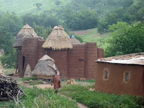
Togo is a long, thin country in West Africa. It has a short beach on the sea. In the north, people build round houses of mud with grass roofs.
Togo is a small, narrow country in West Africa. It has only 51 kilometers of coast on the Gulf of Guinea but stretches about 515 kilometers inland, from beaches and lagoons to the Togo Mountains and northern savanna. About 8.6 million people lived there in 2025, and Lomé is the capital and main port.
Togo, one of Africa's smallest countries, is a strip of land between Ghana and Benin running about 515 km from a 51-km Gulf of Guinea coast to Burkina Faso. Once part of German Togoland and later French Togoland, it became independent on April 27, 1960. About 30 ethnic groups live there, and its economy rests largely on farming and on phosphate. The World Bank counted 8.6 million people in 2025.
Photo: Erik Kristensen, CC BY 2.0, via Wikimedia Commons
Discover Togo
Togo is a small country in Africa.
It is long and thin. Its south touches the sea. Its north is far from the sea. The capital city is Lomé.
Togo is a small country in West Africa, shaped like a long, thin strip. Its coast on the Gulf of Guinea is only 51 kilometers long, but the country stretches about 515 kilometers north to Burkina Faso, with Ghana on one side and Benin on the other.
Lomé, the capital, is the largest city and the main port. About 8.6 million people lived in Togo in 2025, and they belong to about 30 different ethnic groups. French is the official language, and Ewe in the south and Kabiye in the north are widely spoken.
Togo extends about 515 km north from its 51-km Gulf of Guinea coastline, between Ghana to the west and Benin to the east, to Burkina Faso in the north. Until 1884 it was an intermediate zone between the states of Asante and Dahomey; it then became part of the German protectorate of Togoland, and after World War I its eastern part was governed by France. Togo became independent in 1960.
The economy rests largely on agriculture, which employs more than half the labor force, and on phosphate mining near Lomé. The World Bank counted 8,591,626 people in 2025; almost two-fifths of Togolese are under 15. Under a constitution promulgated in May 2024, Togo became a parliamentary republic: the president, Jean-Lucien Savi de Tové, is a largely ceremonial head of state, and Faure Gnassingbé, president since 2005 under the old system, became president of the council, the head of government, in May 2025.

Cities and famous places
Lomé is a busy city by the sea.
It has a big port for ships. In the north, the Batammariba people build tall mud houses. The houses have pointed grass roofs.
Lomé, the capital, spreads along the coast. It became the capital in 1897, and its harbor, opened in 1968, is a busy port for Togo and for neighboring countries that have no coast. Kpalimé, Atakpamé, Sokodé and Kara are towns at the foot of the Togo Mountains.
In the northeast lies Koutammakou, the land of the Batammariba people. Their mud tower-houses, called takienta, have become a symbol of Togo and Benin. The name Batammariba means those who shape the earth. UNESCO made Koutammakou a World Heritage Site in 2004.
Lomé, at the western end of the coast, was chosen as the German colonial capital in 1897 and laid out as a modern town; a jetty followed in 1904 and an artificial harbor in 1968. It is the largest urban center and a transit point for landlocked neighbors, with an international airport at Tokoin; Kpémé, about 35 km to the northeast, ships phosphate. Aného was once the leading European trade center. Other towns, Kpalimé, Atakpamé, Sokodé, Bassar and Kara, lie along the base of the Togo Mountains.
UNESCO inscribed Koutammakou, the Land of the Batammariba, in 2004; the property today also covers part of northwestern Benin. It is a living cultural landscape of fields, terraced hills, water-retaining walls, groves and the sikien (singular takienta), circular or elliptical mud tower-houses that serve technical, practical and symbolic purposes. UNESCO notes that only small game remains in Koutammakou today.
Lagoons, mountains and savanna
Togo has sandy beaches and lagoons.
In the middle are green mountains. The north is grassy savanna. A dry, dusty wind blows there for part of the year.
Togo's narrow coast has sandy beaches backed by shallow lagoons. The largest is Lake Togo. Inland are low plateaus, and then the Togo Mountains run across the middle of the country. Mount Agou, 986 meters high, is the tallest mountain in Togo.
The south has two rainy seasons, and the area near Kpalimé is the wettest. The north has one rainy season, from June to September, and for the rest of the year a dry, dusty wind called the harmattan blows. Grassy savanna covers most of Togo, with forests in the southwest highlands and mangroves on the coast.
Britannica describes six regions: a narrow coast of sandy beaches, tidal flats and lagoons, the largest Lake Togo; the Ouatchi Plateau with its reddish lateritic terre de barre; a tableland drained by the Mono River; the Togo (Togo-Atakora) Mountains, part of a chain from Ghana's Akwapim Hills to Benin's Atakora, crowned by Mount Agou (Baumann Peak), 986 m; the Oti sandstone plateau, a savanna drained by a tributary of the Volta; and a granite and gneiss upland in the far northwest, with the cliffs of Dapaong.
The south has rains from mid-April through June and mid-September through October; the coast is driest, with about 890 mm a year, while the area near Kpalimé gets about 1,800 mm. The north has one rainy season (about 1,150 mm) and is dominated by the harmattan the rest of the year; March and April maxima reach the high 30s °C there. Savanna predominates, forests cover less than one-tenth of the land, and deforestation for slash-and-burn farming and fuelwood has been heavy.
Animals of Togo
Hippos live in Togo's rivers.
Monkeys, snakes and lizards live in many places. Buffalo live in a forest reserve in the north. Many birds and insects live there too.
Togo does not have large herds of wild animals, especially in the south and center. Hippopotamuses and crocodiles live in its rivers, and monkeys, snakes and lizards are common in many areas. In the north, the Kéran reserve has buffalo, warthogs and antelope.
Togo also has many kinds of birds and insects. Along the coast, fishing boats bring in fish such as mackerel, red snapper and sole, as well as shrimp and lobster.
Britannica notes that wild animals are not numerous, especially in the south and center, though hippopotamuses and crocodiles are plentiful in the rivers and monkeys, snakes and lizards are common. The Kéran Forest Reserve near Sansanné-Mango in the north has buffalo, warthogs and antelope, and there are numerous bird and insect species.
Coastal fisheries land mackerel, bass, sea bream, red snapper, triggerfish, dorado, ray and sole, plus shrimp and lobster; most of the catch is eaten locally. Forest loss is the main pressure on habitats: forests now cover less than one-tenth of Togo, and UNESCO notes that only small game remains in Koutammakou.

People, languages and work
About 8.6 million people live in Togo.
People speak French, Ewe, Kabiye and other languages. Many families grow corn, cassava and yams. Togo also sells cocoa and coffee.
About 30 ethnic groups live in Togo. The Ewe are the largest group. Others, such as the Kabre in the north, are among the peoples who have lived in Togo the longest. French is the official language, though it is used mostly in business and government; Ewe is widely spoken in the south and Kabiye in the north.
Most people live in small villages and farm. Families grow corn, cassava, rice, yams, sorghum, millet and peanuts, and cocoa, coffee and cotton are grown to sell abroad. Almost two out of every five people are under 15.
Britannica counts about 30 ethnic groups, many descended from immigrants from elsewhere in West Africa. Gur-speaking peoples such as the Kabre, Moba, Konkomba, Tamberma and Basari live in the north, and Kwa peoples such as the Kposo, Adele and Ahlo in the southwest; the Ewe, the major group, migrated from present-day Nigeria between the 14th and 16th centuries. French is official, while Ewe and Kabiye, Niger-Congo languages, are widely spoken. Almost half the population is Christian, about one-third follows ancestral beliefs and more than one-eighth is Muslim.
Most people live in small rural villages. Staples include corn, cassava, rice, yams, sorghum, millet and peanuts, and exports include cocoa, coffee, shea nuts, cotton and palm kernels. Phosphate, mined at Hahoétoé and Kpogamé northeast of Lomé, is a leading export, and Togo is one of the world's largest phosphate producers. More than three-fifths of its electricity is hydroelectric.
From Togoland to Togo
Long ago, many groups lived in Togo.
Later, Germany ruled it. Then France and Britain shared it. In 1960, Togo became its own country.
Before 1884, Togo was a zone between two powerful states, Asante to the west and Dahomey to the east. In 1884 it became part of a German colony called Togoland, and Lomé became the capital in 1897.
During World War I, British and French troops took over Togoland. Afterward the west was governed by Britain and later joined Ghana, while the east was governed by France. That eastern part became independent Togo on April 27, 1960, with Sylvanus Olympio as its first president.
Until 1884 the region was a buffer between Asante and Dahomey; in the 18th century the Danes held this part of the Slave Coast. In 1884 the German envoy Gustav Nachtigal persuaded coastal chiefs to accept German protection, and Lomé became the colonial capital in 1897. German rule built railways and plantations but used forced labor. British and French troops took the colony in August 1914; in 1922 the League of Nations gave mandates to Britain and France, and in 1946 the territories became UN trusteeships. After a 1956 plebiscite, British Togoland joined the Gold Coast, which became Ghana in 1957.
French Togoland became independent on April 27, 1960, under Sylvanus Olympio. Olympio was killed in a 1963 coup, and in 1967 Gnassingbé Eyadéma seized power and ruled until his death in 2005; a democratic constitution was adopted in 1992. His son Faure Gnassingbé was installed by the military in 2005, stepped down under international pressure and then won an election marred by violence and fraud reports. A truth commission reported in 2012, and a 2024 constitution created a parliamentary system.
Togo on the map
Find Togo on the globe.
It is in West Africa, by the sea. It is long and thin, like a ribbon.
Togo lies on the Gulf of Guinea in West Africa. Ghana is to the west, Benin to the east and Burkina Faso to the north.
A scenic coastal road joins Ghana and Benin, and another road runs from Lomé north all the way to Burkina Faso. Lomé's port also handles goods for neighbors that have no coast, and a second international airport stands at Niamtougou in the north.
Togo is bounded by Ghana to the west, Benin to the east and Burkina Faso to the north, with a 51-km coast on the Gulf of Guinea. The Togo Mountains cross it from south-southwest to north-northeast, continuing a chain that begins in Ghana and ends in Benin; the Oti River in the north drains to the Volta, and the Mono drains the eastern tableland.
Three main road systems serve the country: the coastal road between Ghana and Benin, the road from Lomé north to Burkina Faso, and roads through the cocoa and coffee area of Kpalimé, Badou and Atakpamé. Lomé's port serves landlocked neighbors, and Niamtougou in the north has a second international airport.
- Coastline
- about 51 km
- North to south
- about 515 km
- Highest point
- Mount Agou, 986 m
- People (2025)
- 8,591,626
Amazing facts
-
Togo's beach is very short.
Togo's coast is only 51 kilometers long, but the country stretches about 515 kilometers inland.
From a 51-km Gulf of Guinea coastline, Togo extends about 515 km north to Burkina Faso.
-
Batammariba means those who shape the earth.
The name Batammariba, the people of Koutammakou, means those who shape the earth.
In Ditammari, Batammariba means those who shape the earth, fitting for the builders of the takienta tower-houses.
-
Togo digs up lots of a rock called phosphate.
Togo is one of the world's largest producers of phosphate, a valuable mineral.
Phosphate from Hahoétoé and Kpogamé, northeast of Lomé, makes Togo one of the world's largest producers and is a leading export.
-
A dusty wind blows in northern Togo.
In the north, a warm, dry, dusty wind called the harmattan blows for much of the year.
Outside its single rainy season, northern Togo is dominated by the harmattan, a warm, dry, dust-laden wind.
Words to know
- lagoon
- a shallow body of water separated from the sea by a strip of land
- harmattan
- a warm, dry, dusty wind that blows from the Sahara over West Africa
- protectorate
- a place controlled and defended by a more powerful country
- phosphate
- a mineral rich in phosphorus, used to make fertilizer
- savanna
- a warm grassland with scattered trees
- World Heritage Site
- a place UNESCO lists as important to all people, to be protected
Discovery challenge
-
What shape is Togo?
Which words best describe Togo's shape?
Togo has a 51-km coast and is about 515 km long. What shape does that make?
- Long and thin
- Round like a ball
- A square
Show the answer
Long and thin
Togo is long and thin.
Togo is a narrow strip, only 51 kilometers wide at the coast and about 515 kilometers long.
Togo is a narrow north–south strip between Ghana and Benin.
-
What are the tall houses in northern Togo made of?
What are the takienta tower-houses of Koutammakou made of?
UNESCO's Koutammakou listing features sikien, tower-houses made of what?
- Glass
- Mud
- Ice
Show the answer
Mud
They are made of mud, with grass roofs.
The takienta are mud tower-houses with thatched roofs.
The sikien are mud tower-houses with circular or elliptical forms.
-
What is the capital city of Togo?
Which coastal city is the capital and main port of Togo?
Which city became the capital in 1897 and is Togo's principal port?
- Accra
- Lomé
- Dakar
Show the answer
Lomé
Lomé is the capital, by the sea.
Lomé is the capital, largest city and main port.
Lomé became the colonial capital in 1897; its artificial harbor opened in 1968.
-
Which big animal lives in Togo's rivers?
Which large animal is plentiful in Togo's rivers?
Britannica notes that crocodiles and which large mammal abound in Togo's rivers?
- Hippopotamus
- Polar bear
- Kangaroo
Show the answer
Hippopotamus
Hippos live in Togo's rivers.
Hippopotamuses and crocodiles live in Togo's rivers.
Crocodiles and hippopotamuses abound in the rivers.
-
When did Togo become its own country?
In which year did Togo become independent?
On April 27 of which year did Togo become independent?
- 1884
- 1960
- 2024
Show the answer
1960
Togo became its own country in 1960.
Togo became independent on April 27, 1960.
French Togoland became independent on April 27, 1960, under Sylvanus Olympio.
Animals of Togo
-
Watch
Animal
Common hippopotamus
The common hippopotamus is one of the biggest animals on land, yet it spends most of the day resting in rivers and lakes to keep cool. At night it walks out to graze, and its special skin makes its own sunscreen.
-
 Watch
Animal
African buffalo
The African buffalo is a huge, cow-like grazer with heavy, curving horns. It lives in herds that can number in the thousands, and a herd will rush to protect a calf in danger. It lives across much of Africa south of the Sahara, from open savannas to rainforests.
-
 Watch
Animal
Emperor scorpion
The emperor scorpion is one of the biggest scorpions in the world, up to about 20 centimeters long. It lives in the warm, humid forests of West Africa, where it digs burrows and hunts insects such as termites at night. Mothers give birth to live young and carry them on their backs. Like other scorpions, it glows blue-green under ultraviolet light.
Explore next
-
 Watch
 Country
Benin
Benin is a narrow country in West Africa that stretches from the Atlantic coast up to the Niger River. Lagoons line its short coast, savanna covers the north, and the palaces of the old kingdom of Dahomey still stand at Abomey. About 15 million people live there.
-
 Watch
 Country
Ghana
Ghana is a country in West Africa on the Gulf of Guinea. It has a coast of sandy bays, a belt of rainforest and wide northern savannas, and one of the world's largest artificial lakes, Lake Volta. In 1957 it became independent, and its capital is Accra.
-
 Watch
 Country
Burkina Faso
Burkina Faso is a landlocked country in West Africa, on a wide plateau of savanna that is grassy in the north and dotted with forest in the south. About 24 million people live there. Its name, chosen in 1984, means Land of Incorruptible People, and its capital is Ouagadougou.
-
Watch
Animal
Common hippopotamus
The common hippopotamus is one of the biggest animals on land, yet it spends most of the day resting in rivers and lakes to keep cool. At night it walks out to graze, and its special skin makes its own sunscreen.
-
Watch
Animal
African buffalo
The African buffalo is a huge, cow-like grazer with heavy, curving horns. It lives in herds that can number in the thousands, and a herd will rush to protect a calf in danger. It lives across much of Africa south of the Sahara, from open savannas to rainforests.
-
Watch
Animal
Emperor scorpion
The emperor scorpion is one of the biggest scorpions in the world, up to about 20 centimeters long. It lives in the warm, humid forests of West Africa, where it digs burrows and hunts insects such as termites at night. Mothers give birth to live young and carry them on their backs. Like other scorpions, it glows blue-green under ultraviolet light.
-
 Watch
 Country
Democratic Republic of the Congo
The Democratic Republic of the Congo, or DR Congo, is the second-largest country in Africa. The mighty Congo River curves through its rainforests, volcanoes rise in the east, and its capital, Kinshasa, is a center of music, fashion and popular culture.
-
 Watch
 Country
Ethiopia
Ethiopia is a country on the Horn of Africa with no coast. Much of it is high, rugged land cut by the Great Rift Valley, it is one of the world's oldest countries, and more than 110 million people live there.
For parents & teachers
What children will learn
- Locate Togo between Ghana and Benin and describe its long, narrow shape.
- Name Togo's main regions, from coastal lagoons to northern savanna.
- Describe the Batammariba tower-houses of Koutammakou and why UNESCO protects them.
- Outline Togo's history from German Togoland to independence in 1960.
Recommended ages: 3 to 17 · About 15 minutes
Talk about it
- How might a very narrow country make it easy or hard to travel?
- Why might people build homes from mud in a hot, dry place?
- Why do you think one colony was split between two countries after World War I?
Try at home or in class
- Cut a strip of paper 1 cm wide and 10 cm long to model Togo's coast and length, then compare it with the shape of a country near you.
- Build a small round house from modeling clay with a cone-shaped paper roof, like a takienta.
Key vocabulary: lagoon, harmattan, protectorate, phosphate, savanna, World Heritage Site
Where these facts come from
- Wikidata , Wikimedia Foundation (CC0 1.0)
- Natural Earth vector data , Natural Earth (NACIS) (Public domain)
- UNESCO World Heritage List , UNESCO World Heritage Centre (Linked as a reference; site facts come from Wikidata)
- Togo (introduction, quick facts, land, climate, plant and animal life, ethnic groups, languages, religion) , Encyclopaedia Britannica
- Togo: Settlement patterns (demographic trends, economy, resources, trade, transportation) , Encyclopaedia Britannica
- Togo: History (German occupation, mandate, trusteeship, independence) , Encyclopaedia Britannica
- Togo: Early years and coups (Togo under Eyadéma) , Encyclopaedia Britannica
- Togo: Faure Gnassingbé's presidency , Encyclopaedia Britannica
- Koutammakou, the Land of the Batammariba , UNESCO World Heritage Centre
- Population, total: Togo , World Bank
- PlayOwl region table, version 1 , PlayOwl (PlayOwl original data)
- flag-icons 7.5.0 , Panayiotis Lipiridis and contributors (MIT)
- Wikimedia Commons , Wikimedia Foundation (Per file (public domain, CC0, CC BY or CC BY-SA); see each media record)
Checked, not yet human-reviewed. Last updated October 27, 2026. Spotted a mistake? Tell us.