
 Country
Africa
Burkina Faso
Burkina Faso is a country in West Africa with no sea. It has grassy plains, three rivers called the Volta, and elephants.
Burkina Faso is a landlocked country in West Africa, on a wide plateau of savanna that is grassy in the north and dotted with forest in the south. About 24 million people live there. Its name, chosen in 1984, means Land of Incorruptible People, and its capital is Ouagadougou.
Burkina Faso, called Upper Volta until 1984, is a landlocked West African state on a lateritic plateau cut by the Black, Red and White Volta rivers. It spans the semiarid Sahelian zone in the north and the wetter Sudanic zone in the south, and had about 24.1 million people in 2025 (World Bank), more than two-fifths of them under 15.
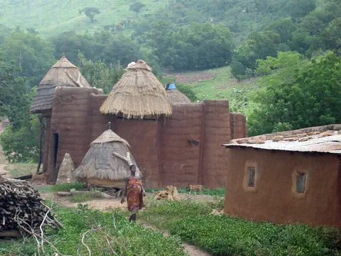
Photo: The black photographer, CC0 1.0, via Wikimedia Commons
Discover Burkina Faso
Burkina Faso is a country in West Africa.
It has no sea. The land is wide and mostly flat. Grass grows in the north, and more trees grow in the south. The capital city is Ouagadougou.
Burkina Faso is a landlocked country in West Africa, which means it has no coast. Its capital, Ouagadougou, is in the middle of the country, about 800 kilometers from the Atlantic Ocean.
Most of the country sits on a wide, gently sloping plateau covered in savanna, a grassland with scattered trees. The north is grassy and dry, and the south has more trees. About 24 million people lived there in 2025. The country's name, chosen in 1984, means Land of Incorruptible People: people who cannot be bribed.
Burkina Faso is a landlocked country in western Africa on an extensive plateau that tilts slightly to the south. Britannica describes its savanna as grassy in the north, giving way gradually to sparse forest in the south. Ouagadougou, the capital, lies in the center, about 800 km from the Atlantic.
A former French colony, the country became independent as Upper Volta in 1960 and took the name Burkina Faso, Land of Incorruptible People, in 1984. The World Bank put its population at 24,074,580 in 2025. The eastern and central regions are the most densely settled, holding about half of all the people, and more than two-thirds of the population is rural.
Cities and famous places
Ouagadougou is the biggest city.
It has big trees and a market. Bobo-Dioulasso is a city in the west. Long ago, people built tall stone walls at a place called Loropéni.
Ouagadougou is the capital and largest city. It was once the capital of a Mossi kingdom, and the Mossi king, called the morho naba, still lives there. Every two years it hosts FESPACO, a big festival of African films.
Bobo-Dioulasso, in the west, was the country's business center when the railroad from the coast ended there. In the south, the Ruins of Loropéni are stone walls up to six meters tall around an abandoned settlement at least 1,000 years old. They were Burkina Faso's first World Heritage Site, listed in 2009.
Ouagadougou, the capital and largest city, was the seat of the Mossi kingdom of Wagadugu (founded in the 15th century) and is still the residence of the morho naba. Britannica describes a city of large trees and modern public buildings beside traditional neighborhoods, with a market, a crafts center and the National Museum; it hosts the biennial Pan-African Film Festival (FESPACO). Bobo-Dioulasso was the economic capital while it was the terminus of the railroad from Abidjan, and lost some of that role after the line reached Ouagadougou in 1955.
UNESCO inscribed the Ruins of Loropéni in 2009: laterite walls up to 6 m high around an abandoned settlement, the best preserved of ten fortresses in the Lobi area, dated to at least the 11th century and flourishing from the 14th to 17th centuries with the trans-Saharan gold trade. The Ancient Ferrous Metallurgy Sites (2019) include about fifteen standing furnaces; Douroula, from the 8th century BCE, is the oldest evidence of iron production found in the country.

Plateau, rivers and seasons
Three rivers called the Volta flow across Burkina Faso.
Some rivers dry up in the dry season. A hot, dusty wind blows from the Sahara. Then the rain comes in summer.
Burkina Faso's three main rivers are the Black Volta, the Red Volta and the White Volta. They all flow south and join together in Ghana to make the Volta River. In the dry season, some rivers shrink to dry beds.
The weather is mostly sunny, hot and dry. From mid-February to June, a hot, dusty wind called the harmattan blows from the Sahara and the temperature can reach about 40 °C in the shade. Rain falls from June to September. The south gets about 1,000 millimeters of rain a year, and the dry north less than 250.
A layer of red, iron-rich lateritic rock covers the crystalline basement and is deeply cut by the Black Volta (Mouhoun), Red Volta (Nazinon) and White Volta (Nakambé), which converge in Ghana to form the Volta; the Oti, another Volta tributary, rises in the southeast. River flow varies greatly with the seasons. In the southwest, sandstone plateaus end at the Banfora Escarpment, about 150 m high. Much of the soil is infertile.
The Sahelian zone in the north is semiarid steppe with three to five months of often erratic rain; the Sudanic zone to the south has a tropical wet-dry climate with more rain. Britannica distinguishes four seasons: cool and dry (mid-November to mid-February, nights near 16 °C), hot (mid-February to June, about 40 °C in the shade, with the harmattan), rainy (June to September) and intermediate. Annual rainfall falls from about 1,000 mm in the south to under 250 mm in the north. Shea trees and baobabs grow in the southern woodland.
Animals of Burkina Faso
Elephants live in Burkina Faso's parks.
Hippos and crocodiles live in the rivers. Buffalo, antelope and monkeys live there too. Many birds fly over the savanna.
Burkina Faso's wild animals include buffalo, antelope, hippopotamuses, elephants, crocodiles and monkeys, and there are many kinds of birds, insects and river fish. Its national parks include Po in the south, Arly in the southeast and W in the east, which crosses the borders into Benin and Niger.
W and Arly are part of a huge protected area shared by three countries, called the W-Arly-Pendjari Complex. UNESCO says it has the largest group of elephants in West Africa and the region's last strong group of lions, and is a safe home for animals that have disappeared from much of the region.
Britannica lists buffalo, antelope, lions, hippopotamuses, elephants, crocodiles and monkeys, with rich bird and insect life and many fish species in the rivers; the IUCN Red List's 2025 lion assessment marks lions in Burkina Faso as possibly still present rather than confirmed. The national parks include Po (south-center), Arly (southeast) and W (east), which straddles the borders with Benin and Niger.
W and Arly belong to the W-Arly-Pendjari Complex, a World Heritage Site of 1,714,831 ha shared by Niger, Burkina Faso and Benin and made of nine protected areas in the Volta basin. UNESCO calls it the largest and most important continuum of land, wetland and aquatic ecosystems in the West African savanna belt. It holds about 85 percent of the region's savanna elephants, the only viable lion population in the area and almost all the large mammals typical of West Africa, from African manatees to topi antelope. Seven of the nine fish species found only in the Volta basin live there. Poaching, illegal grazing and spreading farmland remain threats.

People, languages and food
About 24 million people live in Burkina Faso.
Many people speak a language called Moore. Most families live in villages. They grow millet, sorghum, corn and rice.
All citizens of Burkina Faso are called Burkinabé, whatever their background. The largest group is the Mossi, and their language, Moore, is spoken by most people. Dyula is widely used for buying and selling. The Gurunsi, Senufo, Bwa, Lobi, Fulani, Hausa, Tuareg and others live there too. In 2024 all the national languages became official, and French and English are working languages.
More than two-thirds of people live in villages. Families grow sorghum, millet, corn, peanuts and rice to eat, and cotton to sell. Mossi antelope masks can be 2 meters tall, and soccer is the country's favorite sport.
Burkinabé is the name for all citizens. The Mossi, who speak Moore, a Gur language of the Niger-Congo family, are the major group; other Gur-speaking peoples include the Gurunsi, Senufo, Bwa and Lobi, while the Samo, Marka, Busansi and Dyula speak Mande languages, and the Hausa, Tuareg and Fulani are also present. A constitutional amendment promulgated in January 2024 gave all national languages official status and made French, the former official language, a working language alongside English. More than half the population is Muslim, about one-fifth Roman Catholic and about one-sixth follow traditional religions.
About nine-tenths of people farm or raise livestock, mostly for their own needs: sorghum, millet, corn, peanuts, rice and fonio are grown for food, and cotton, shea nuts, sesame and sugarcane are exported. Britannica notes Mossi antelope masks up to 2 m tall, Bobo butterfly masks and Lobi wood carving. Severe droughts from time to time have led many people to move from the countryside to towns, or to Côte d'Ivoire and Ghana.
Kingdoms and a new name
People have lived in Burkina Faso for a very long time.
Long ago, people made iron in big furnaces. Kings ruled the Mossi kingdoms. Later, France ruled the land. In 1960, it became its own country.
People in Burkina Faso were making iron about 2,700 years ago, and Douroula has the oldest signs of iron-making found in the country. The Bobo, Lobi and Gurunsi are the earliest known peoples. In about the 1400s, horsemen from the south founded the Gurma and Mossi kingdoms, and the Mossi kingdom of Ouagadougou became the strongest.
France took control in the 1890s, and in 1919 it made the land a colony called Upper Volta. On August 5, 1960, Upper Volta became independent. In 1984 it was renamed Burkina Faso.
Neolithic axes have been found in the north, and UNESCO dates iron production at Douroula to the 8th century BCE. The Bobo, Lobi and Gurunsi are the earliest known inhabitants. About the 15th century, horsemen from the south founded the Gurma and Mossi kingdoms; the Ouagadougou Mossi state, headed by the morho naba, resisted invasions by the Songhai and Fulani and traded with the Dyula, Hausa and Asante. France took control of the region from 1895, made Upper Volta a separate colony in 1919, divided it among neighboring colonies in 1932 and restored it in 1947. Independence was proclaimed on August 5, 1960.
The army has taken power several times since then: in 1966, 1980, 1982 and 1983, when Capt. Thomas Sankara came to power and renamed the country in 1984, and in 1987, when Blaise Compaoré took over and later ruled for 27 years. Protests in 2014 ended his rule, and elections were held in 2015. Attacks by armed groups grew after 2015, forcing more than a million people from their homes. Two military coups took place in 2022, and in 2024 a new charter extended the military-led transition by five years.
Burkina Faso on the map
Find Burkina Faso on the globe.
It is in West Africa. It has no sea. Six countries are all around it.
Burkina Faso is surrounded by six countries: Mali to the north and west, Niger to the northeast, Benin to the southeast, and Togo, Ghana and Côte d'Ivoire to the south.
Because it has no coast, a long railroad links Ouagadougou to the port of Abidjan in Côte d'Ivoire, about 1,100 kilometers away. The three Volta rivers flow south out of the country into Ghana, and W National Park sits right where Burkina Faso, Niger and Benin meet.
Burkina Faso is bounded by Mali to the north and west, Niger to the northeast, Benin to the southeast, and Côte d'Ivoire, Ghana and Togo to the south. Its capital lies about 800 km from the Atlantic, and the lack of direct access to the sea is one of the obstacles to industry that Britannica names.
The railroad from Ouagadougou to the port of Abidjan is about 1,100 km long, about 500 km of it inside Burkina Faso, serving Koudougou, Bobo-Dioulasso and Banfora on the way. International airports are at Ouagadougou and Bobo-Dioulasso. The Volta headwaters drain south to Ghana, and the W park straddles the tri-border with Niger and Benin.
- Neighbors
- Mali, Niger, Benin, Togo, Ghana and Côte d'Ivoire
- Capital to the Atlantic
- about 800 km
- Railroad to Abidjan
- about 1,100 km, about 500 km of it in Burkina Faso
- People (2025)
- 24,074,580
Amazing facts
-
The name Burkina Faso means Land of Incorruptible People.
In 1984 Upper Volta was renamed Burkina Faso, which means Land of Incorruptible People: people who cannot be bribed.
The name Burkina Faso, adopted in 1984 in place of Upper Volta, means Land of Incorruptible People.
-
People in Burkina Faso made iron long, long ago.
Iron was being made at Douroula in Burkina Faso about 2,700 years ago, and at four other old iron-making sites, about fifteen furnaces still stand.
UNESCO dates iron production at Douroula to the 8th century BCE; the other four metallurgy sites keep standing natural-draught furnaces from the second millennium CE.
-
The stone walls at Loropéni are very tall and very old.
The stone walls at Loropéni are up to six meters tall and at least 1,000 years old.
Loropéni's laterite perimeter walls reach 6 m and enclose 11,130 m²; radiocarbon dates place the enclosure at least in the 11th century CE.
-
Some masks in Burkina Faso are taller than a grown-up.
Mossi antelope masks can be as tall as 2 meters, taller than most adults.
Britannica notes Mossi antelope masks up to 2 m tall, Bobo butterfly masks and Lobi wood carvings among the country's best-known arts.
-
Ouagadougou has a big film festival.
Every two years, Ouagadougou hosts FESPACO, the Pan-African Film Festival.
The biennial Pan-African Film Festival (FESPACO) is held in Ouagadougou, alongside an International Crafts Fair for the country's artisans.
Words to know
- landlocked
- having no coastline; surrounded by land and other countries
- plateau
- a large area of high, fairly flat land
- savanna
- a warm grassland with scattered trees and bushes
- harmattan
- a hot, dry, dusty wind that blows from the Sahara across West Africa
- escarpment
- a long, steep slope or cliff at the edge of a plateau
- smelting
- heating rock that contains metal so the metal melts out
- World Heritage Site
- a place UNESCO lists as important to all people, to be protected
Discovery challenge
-
What is the capital city of Burkina Faso?
Which city is the capital of Burkina Faso?
Which city, once the seat of the Mossi kingdom of Wagadugu, is Burkina Faso's capital?
- Bobo-Dioulasso
- Ouagadougou
- Banfora
Show the answer
Ouagadougou
Ouagadougou is the capital of Burkina Faso.
Ouagadougou, in the middle of the country, is the capital and largest city.
Ouagadougou was the seat of the Mossi kingdom of Wagadugu, founded in the 15th century, and the morho naba still lives there.
-
Which river has three parts in Burkina Faso?
The Black, Red and White rivers of Burkina Faso all flow into which river?
The Mouhoun, Nazinon and Nakambé converge in Ghana to form which river?
- The Nile
- The Congo
- The Volta
Show the answer
The Volta
The Black, Red and White Volta rivers flow across Burkina Faso.
The Black, Red and White Volta join together in Ghana to make the Volta River.
The Black (Mouhoun), Red (Nazinon) and White (Nakambé) Volta converge in Ghana to form the Volta.
-
What is the hot, dusty wind called?
What is the hot, dusty wind that blows from the Sahara in the hot season called?
Which dry, dust-laden wind off the Sahara dominates Burkina Faso's hot season?
- The harmattan
- A typhoon
- The monsoon
Show the answer
The harmattan
The harmattan is a hot, dusty wind.
From mid-February to June, the harmattan blows hot, dusty air from the Sahara.
The harmattan prevails from mid-February to June, when maximum temperatures reach about 40 °C in the shade.
-
What did people trade near Loropéni long ago?
The stone walls of Loropéni grew rich from trade in which metal?
UNESCO links the fortified settlements of the Lobi area, including Loropéni, to the trans-Saharan trade in which metal?
- Gold
- Copper
- Tin
Show the answer
Gold
People dug and traded gold there long ago.
Loropéni flourished with the gold trade across the Sahara, from the 1300s to the 1600s.
The Lohron or Koulango peoples controlled gold extraction and processing; the settlement flourished from the 14th to the 17th century.
-
When did Burkina Faso become its own country?
In which year did Upper Volta, now Burkina Faso, become independent?
In which year was the independence of Upper Volta proclaimed, on August 5?
- 1919
- 1960
- 1984
Show the answer
1960
It became its own country in 1960.
Upper Volta became independent in 1960 and was renamed Burkina Faso in 1984.
Independence was proclaimed on August 5, 1960; 1919 was the founding of the colony and 1984 the change of name.
Animals of Burkina Faso
-
 Watch
Animal
Common hippopotamus
The common hippopotamus is one of the biggest animals on land, yet it spends most of the day resting in rivers and lakes to keep cool. At night it walks out to graze, and its special skin makes its own sunscreen.
-
 Watch
Animal
African buffalo
The African buffalo is a huge, cow-like grazer with heavy, curving horns. It lives in herds that can number in the thousands, and a herd will rush to protect a calf in danger. It lives across much of Africa south of the Sahara, from open savannas to rainforests.
Explore next
-
Watch
Animal
Common hippopotamus
The common hippopotamus is one of the biggest animals on land, yet it spends most of the day resting in rivers and lakes to keep cool. At night it walks out to graze, and its special skin makes its own sunscreen.
-
Watch
Animal
African buffalo
The African buffalo is a huge, cow-like grazer with heavy, curving horns. It lives in herds that can number in the thousands, and a herd will rush to protect a calf in danger. It lives across much of Africa south of the Sahara, from open savannas to rainforests.
-
 Watch
 Country
Ghana
Ghana is a country in West Africa on the Gulf of Guinea. It has a coast of sandy bays, a belt of rainforest and wide northern savannas, and one of the world's largest artificial lakes, Lake Volta. In 1957 it became independent, and its capital is Accra.
-
 Watch
 Country
Mali
Mali is one of the largest countries in Africa. Its north is part of the Sahara, its middle is the dry Sahel, and its south has savanna. The Niger River flows through it, and long ago great empires grew rich here from trade in gold. About 25.2 million people lived there in 2025.
-
 Watch
 Country
Benin
Benin is a narrow country in West Africa that stretches from the Atlantic coast up to the Niger River. Lagoons line its short coast, savanna covers the north, and the palaces of the old kingdom of Dahomey still stand at Abomey. About 15 million people live there.
-
 Watch
 Country
Togo
Togo is a small, narrow country in West Africa. It has only 51 kilometers of coast on the Gulf of Guinea but stretches about 515 kilometers inland, from beaches and lagoons to the Togo Mountains and northern savanna. About 8.6 million people lived there in 2025, and Lomé is the capital and main port.
-
 Watch
 Country
Democratic Republic of the Congo
The Democratic Republic of the Congo, or DR Congo, is the second-largest country in Africa. The mighty Congo River curves through its rainforests, volcanoes rise in the east, and its capital, Kinshasa, is a center of music, fashion and popular culture.
-
 Watch
 Country
Ethiopia
Ethiopia is a country on the Horn of Africa with no coast. Much of it is high, rugged land cut by the Great Rift Valley, it is one of the world's oldest countries, and more than 110 million people live there.
For parents & teachers
What children will learn
- Locate Burkina Faso and its six neighbors, and explain what landlocked means.
- Describe how rainfall and plants change from the Sahelian north to the Sudanic south.
- Describe the peoples, languages and ways of life of Burkina Faso without treating them as one culture.
- Outline the country's history from ancient iron smelting to Upper Volta and Burkina Faso.
Recommended ages: 3 to 17 · About 15 minutes
Talk about it
- How might a country with no coast send its cotton and gold to other countries?
- How would your week change if it hardly rained for eight months of the year?
- Why do you think people long ago built such tall stone walls at Loropéni?
Try at home or in class
- Measure how much rain falls in a week with a straight-sided jar outside, then compare it with Burkina Faso's 250 mm a year in the north and 1,000 mm in the south.
- Draw a north-to-south strip of Burkina Faso, from grassy savanna to woodland, and add the three Volta rivers flowing south.
Key vocabulary: landlocked, plateau, savanna, harmattan, escarpment, smelting, World Heritage Site
Where these facts come from
- Wikidata , Wikimedia Foundation (CC0 1.0)
- Natural Earth vector data , Natural Earth (NACIS) (Public domain)
- UNESCO World Heritage List , UNESCO World Heritage Centre (Linked as a reference; site facts come from Wikidata)
- Burkina Faso (introduction, land, climate, plant and animal life, people, languages, religion, settlement) , Encyclopaedia Britannica
- Burkina Faso: Demographic trends (economy, transportation, government) , Encyclopaedia Britannica
- Burkina Faso: Health and welfare (education, cultural life, early history, colonial period) , Encyclopaedia Britannica
- Burkina Faso: Independence , Encyclopaedia Britannica
- Ouagadougou , Encyclopaedia Britannica
- Ruins of Loropéni , UNESCO World Heritage Centre
- Ancient Ferrous Metallurgy Sites of Burkina Faso , UNESCO World Heritage Centre
- W-Arly-Pendjari Complex , UNESCO World Heritage Centre
- Population, total: Burkina Faso , World Bank
- Lion (Panthera leo), 2025 global assessment , IUCN Red List
- PlayOwl region table, version 1 , PlayOwl (PlayOwl original data)
- flag-icons 7.5.0 , Panayiotis Lipiridis and contributors (MIT)
- Wikimedia Commons , Wikimedia Foundation (Per file (public domain, CC0, CC BY or CC BY-SA); see each media record)
Checked, not yet human-reviewed. Last updated October 27, 2026. Spotted a mistake? Tell us.
Picture credits
- Photo: The black photographer, CC0 1.0, via Wikimedia Commons · source · license
- Photo: Maarten van der Bent, CC BY-SA 2.0, via Wikimedia Commons · source · license
- Photo: Giles Laurent, CC BY-SA 4.0, via Wikimedia Commons · source · license
- Photo: Diego Delso, CC BY-SA 4.0, via Wikimedia Commons · source · license
- Photo: Paul M Rae, CC BY 2.5, via Wikimedia Commons · source · license