
 Country
Australia and Oceania
Guam
Guam is a warm, green island far out in the Pacific Ocean. The Chamorro people have lived there for thousands of years. Long ago they built houses on stone pillars.
Guam is the biggest and southernmost of the Mariana Islands, in the western Pacific Ocean. It is a territory of the United States, and its first people, the Chamorros, arrived by canoe more than 3,500 years ago. The 2020 census counted 153,836 people.
Guam, the largest and southernmost of the Mariana Islands, is an unincorporated territory of the United States, about 9,300 km west of San Francisco and 2,600 km east of Manila. Chamorro seafarers settled the Marianas more than 3,500 years ago; Spain claimed Guam in 1565 and the United States took it in 1898. The 2020 census counted 153,836 people.
Photo: Abasaa, public domain, via Wikimedia Commons
Discover Guam
Guam is an island in the Pacific Ocean.
It is warm all year. Hagåtña is the capital. People speak English and Chamorro.
Guam is an island in the western Pacific Ocean, the largest and most southern of the Mariana Islands. It is about 9,300 kilometers west of San Francisco and 2,600 kilometers east of Manila, in the Philippines.
Guam is a territory of the United States; under a 1950 law, Chamorros became US citizens. It has its own elected governor and legislature. English and Chamorro are the official languages, the US dollar is the money, and the capital is Hagåtña, also called Agana.
Britannica describes Guam as an unincorporated territory of the United States and the largest, most populous and southernmost of the Mariana Islands. Under the Organic Act of Guam, passed by Congress in 1950, Chamorros were granted US citizenship. Guam elects a governor and a one-house legislature and sends a delegate with limited voting rights to the US House of Representatives; residents do not vote in national elections, though they can vote in presidential primaries.
The US Census Bureau's 2020 Island Areas census counted 153,836 people, 3.5% fewer than in 2010; Dededo was the most populous municipality, with just under 45,000. Britannica notes that about one-third of the island's land is owned by the US armed forces, including Andersen Air Force Base in the north and naval facilities around the island.
Hagåtña, Dededo and Tumon Bay
Hagåtña is the capital. It sits by a blue bay.
Dededo is the town with the most people. Big hotels stand along Tumon Bay.
Hagåtña, on the west coast, is the capital. The photo, taken from a hill above the town, shows its white buildings, green trees and the bright blue bay beyond.
Dededo, in the north-central part of the island, has the most people of any village. Tumon Bay, north of the capital, has been built up for visitors, with many hotels along its beach. An international airport links Guam with Asia, other Pacific islands, Hawaii and the US mainland.
Hagåtña (Agana) is the capital, though it is home to only a small part of the population; Dededo, in the north-central part of the island, was the most populous municipality in 2020.
Tumon Bay has been heavily developed for tourism, with luxury hotels, and Britannica calls tourism the most prominent part of the economy. Britannica notes that work at the military bases drew many islanders away from subsistence farming and fishing. The hero photo looks over Hagåtña and its bay from Fort Santa Agueda, a hilltop fort.
Limestone plateau and volcanic hills
The north of Guam is flat and covered in jungle.
The south has green hills. It is warm and rainy. Sometimes big storms called typhoons come.
Guam has two halves. The north is a flat limestone plateau about 150 meters high, covered in thick jungle. The south is made of volcanic hills covered mostly in sword grass, rising to Mount Lamlam, 406 meters high.
The temperature stays between about 20 and 30 °C all year. About 2,400 millimeters of rain falls in a year, most of it from May or June to November. Typhoons, powerful tropical storms, sometimes strike the island. Offshore lies the Mariana Trench, the deepest known ocean trench on Earth; its deepest part, the Challenger Deep, is southwest of Guam.
Britannica describes an island sharply divided into a northern limestone plateau, generally about 150 m high and covered in jungle, and southern volcanic hills, mostly under sword grass, whose lower slopes carry younger limestones. Mount Lamlam (406 m) rises in the southwest, with Mount Bolanos (378 m) to its southeast.
The tropical climate is moderated by northeast trade winds and the North Equatorial Current; temperatures stay between about 20 and 30 °C, and about 2,400 mm of rain falls a year, three-fourths of it in the wet season from May or June to November. Typhoons strike at irregular intervals. Offshore, the Mariana Trench, formed where the Pacific Plate is forced below the Mariana Plate, reaches its greatest depth in the Challenger Deep southwest of Guam; it was made a US national monument in 2009.
Lost birds and a rail that came back
Long ago, many birds sang in Guam's forests.
Then a snake came on a ship, and many birds were lost. People work hard to stop the snakes from reaching new places. A rare bird called the ko'ko' was moved to a small island to keep it safe.
The brown treesnake is not from Guam. It was first seen there in the 1950s, probably after hiding on cargo ships from New Guinea. With nothing to hunt it, it spread fast and helped wipe out nine of Guam's 11 kinds of native forest birds. It also climbs power lines and causes power cuts.
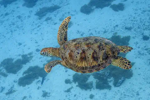
The Guam rail, or ko'ko', a bird found only on Guam, almost disappeared. In 2010 wildlife workers released ko'ko' on tiny Cocos Island, off the southwest coast, which in 2020 was its only wild home on Guam. Green sea turtles nest on Cocos Island's beaches too. The turtle photo was taken in French Polynesia.
USGS says the brown treesnake (Boiga irregularis), native to parts of Indonesia, the Solomon Islands, New Guinea and Australia, was first sighted on Guam in the 1950s, probably after stowing away on cargo ships from New Guinea. With no natural predators there it multiplied rapidly; it was a major contributor to the loss of nine of 11 native forest birds and to declines of native lizards, bats and other birds, and it causes costly power outages. USGS says there is no known way to remove it entirely; the strategy is to stop it reaching new places.
The ko'ko' (Guam rail), endemic to Guam, was introduced to Cocos Island in 2010 by the Guam Division of Aquatic and Wildlife Resources to save it from extinction in the wild. In 2020, USGS reported that brown treesnakes had been found on Cocos Island for the first time, and agencies began removing them. The island also has endangered Mariana skinks and nesting green sea turtles (haggan). The turtle photo is from Moorea, French Polynesia.
Chamorro language, family and many backgrounds
The Chamorro people are Guam's first people.
Many families speak Chamorro at home. Big extended families matter a lot. People also speak English.
The Chamorros (also spelled CHamoru) are Guam's native people. Their ancestors sailed from Southeast Asia, and over the centuries Spanish, Filipino, Mexican and other families joined them. Chamorros and other Micronesians make up about half of Guam's people, and many others have Filipino, Korean, Chinese or other roots.
Chamorro is still spoken in many homes, while English is the language of school and business. The extended family is the center of everyday life. Traditional arts, music and dance have had a revival.
Britannica describes the Chamorros as of Malayo-Indonesian descent with considerable Spanish, Filipino, Mexican and other European and Asian ancestry; with other Micronesians they account for about half the population. There are large communities from the Philippines and South Korea, and migrants from the Federated States of Micronesia, Palau and the Marshall Islands. Chamorro, an Austronesian language that has absorbed many Spanish words, is still used in many homes, while English is the language of education and commerce; the name Chamorro is traced to Chamorri, 'noble'.
Spanish rule brought Roman Catholicism. The extended family remains the main social unit, traditional arts, music and dance have revived, and several local days are kept alongside US national holidays.
Proas, latte stones and a long journey
Long ago, Chamorro sailors crossed the sea in big canoes.
They built houses on stone pillars called latte. Later, Spain ruled the island. Then the United States did.
Chamorro sailors reached the Mariana Islands more than 3,500 years ago in large outrigger canoes called proas. About 1,000 years ago they began building latte: two-piece stone pillars of limestone that held up buildings. Some still stand today.
In 1521 Ferdinand Magellan's ships crossed the Pacific and landed on Guam. Spain claimed the island in 1565 and ruled it for more than 300 years. After the Spanish-American War of 1898, the United States took control. During World War II, Japan occupied Guam from 1941 until US forces retook it in 1944, a hard time for the island's people.
The US National Park Service says seafaring Chamorros settled the Marianas over 3,500 years ago, sailing proas from Southeast Asia (Britannica: by the second quarter of the 2nd millennium BCE), and that around 1,000 years ago they began building two-piece megalithic limestone pillars, the latte stones, which still exist on several islands. Magellan sighted the Marianas in 1521 and made landfall on Guam. Spain claimed Guam in 1565, bringing cultural changes including Roman Catholicism, and the United States took control after the Spanish-American War of 1898.
Hours after the attack on Pearl Harbor, Japanese forces attacked and captured Guam; the NPS describes a harsh occupation from December 10, 1941, to July 21, 1944, when American forces landed and retook the island over 21 days. The 1950 Organic Act made Guam an unincorporated territory with US citizenship for Chamorros. Afterward the island became an important US military base.
Guam on the map
Find the Pacific Ocean on the globe.
Look east of the Philippines. A line of small islands runs north to south. Guam is the biggest one, at the bottom.
Guam is in the western Pacific Ocean, at the southern end of the Mariana Islands chain. The Northern Mariana Islands stretch away to the north, the Philippines are about 2,600 kilometers to the west, and San Francisco is about 9,300 kilometers to the east.
Guam has no land borders. At the globe's size it is too small for an outline, so PlayOwl marks it with dots.
Guam lies at about 13.5° N, 144.8° E, the southern end of the Mariana arc, about 2,600 km east of Manila and 9,300 km west of San Francisco. Most of the Mariana Trench lies east and south of the Marianas, with the Challenger Deep southwest of Guam.
Guam has no land borders. At the globe's scale it has no outline, so the map uses markers: Hagåtña, Dededo, Tumon Bay, Mount Lamlam and Umatac.
- West of San Francisco
- about 9,300 km
- Mount Lamlam
- 406 m
- People (2020 census)
- 153,836
- Rain in a year
- about 2,400 mm
Amazing facts
-
Long ago, Chamorros built stone pillars called latte.
About 1,000 years ago, Chamorros began building latte: limestone pillars in two pieces that held up buildings. Some still stand.
Latte stones are two-piece megalithic limestone pillars that Chamorros began building around 1,000 years ago; examples survive on several of the Mariana Islands.
-
Snakes on Guam can turn the lights off by climbing power lines!
Brown treesnakes climb electrical lines on Guam and cause power cuts.
Brown treesnakes crawl on electrical lines and cause expensive power outages and electrical damage on Guam.
-
The deepest place in the ocean is near Guam.
The Challenger Deep, the deepest known place in the ocean, is in the Mariana Trench southwest of Guam.
The Challenger Deep, where the Trieste dived to 10,916 m, lies on the floor of the Mariana Trench southwest of Guam; the trench became a US national monument in 2009.
-
The word Chamorro is said to come from a word for noble.
The name Chamorro is traced to the word Chamorri, which means noble.
Britannica derives Chamorro from Chamorri or Chamoli, 'noble'; the Chamorro language is Austronesian with many Spanish loanwords.
Words to know
- territory
- an area that belongs to a country but is not one of its states or provinces
- latte stone
- a two-piece stone pillar that ancient Chamorros used to hold up buildings
- proa
- a large outrigger sailing canoe used by Chamorro seafarers
- invasive species
- a plant or animal brought to a new place, where it spreads and causes harm
- plateau
- a large, flat area of high land
- typhoon
- a powerful tropical storm in the western Pacific, like a hurricane
Discovery challenge
-
What did Chamorros build long ago to hold up their buildings?
What are latte?
What were latte, which Chamorros began building about 1,000 years ago?
- Ice houses
- Stone pillars
- Metal towers
Show the answer
Stone pillars
Stone pillars called latte.
Two-piece stone pillars of limestone that held up buildings.
Two-piece megalithic limestone pillars supporting buildings.
-
Which animal came to Guam by ship and caused trouble for the birds?
Which invasive animal helped wipe out most of Guam's native forest birds?
Which invasive predator, first sighted in the 1950s, contributed to the loss of nine of 11 native forest birds on Guam?
- The brown treesnake
- The green sea turtle
- The ko'ko'
Show the answer
The brown treesnake
The brown treesnake.
The brown treesnake, which probably arrived on cargo ships from New Guinea.
Boiga irregularis, the brown treesnake.
-
What is the capital of Guam?
Which town, also called Agana, is the capital of Guam?
Which town is Guam's capital, though Dededo has more people?
- Manila
- Honolulu
- Hagåtña
Show the answer
Hagåtña
Hagåtña is the capital.
Hagåtña. Manila is the capital of the Philippines, and Honolulu is in Hawaii.
Hagåtña (Agana).
-
Which country is Guam a part of?
Guam is a territory of which country?
Under the 1950 Organic Act, Guam is an unincorporated territory of which country?
- Japan
- The United States
- Spain
Show the answer
The United States
The United States.
The United States, since 1898.
The United States; Spain ruled before 1898, and Japan occupied it from 1941 to 1944.
Places to discover in Guam
Animals of Guam
Explore next
- Watch Natural wonder Mariana Trench The Mariana Trench is a long, curving valley in the floor of the western Pacific Ocean, near the island of Guam. Its deepest spot, the Challenger Deep, is the deepest place known in the whole ocean, close to 11,000 meters down. If Mount Everest stood on the bottom, its peak would still be about 2 kilometers under water.
-
 Watch
 Country
Micronesia
The Federated States of Micronesia is a country in the western Pacific made of four states: Yap, Chuuk, Pohnpei and Kosrae. Its islands range from high islands to low coral atolls, spread across about 2,800 kilometers of ocean. Off Pohnpei lie the stone ruins of Nan Madol, a World Heritage site. The 2023 census counted 75,817 people.
-
 Watch
 Country
Philippines
The Philippines is an island country in Southeast Asia, in the western Pacific Ocean. It has more than 7,000 islands, about 50 volcanoes and rich coral reefs, and about 112.7 million people were counted there in 2024.
-
 Watch
 Country
United States
The United States is a large country in North America made of 50 states, from icy Alaska to the warm islands of Hawaii. It has the Grand Canyon, the Mississippi River and Yellowstone, and about 342 million people live there.
-
Watch
Animal
Green sea turtle
The green sea turtle is the largest sea turtle with a hard shell. It lives in warm seas around the world and, unlike other sea turtles, grown-ups eat mostly seagrass and algae. Females swim hundreds or even thousands of kilometers to lay their eggs on the beaches where they hatched long ago.
-
 Watch
 Country
Australia
Australia is a country and the smallest continent, surrounded by ocean in the Southern Hemisphere. Much of its middle is dry and flat, most people live near the coast, and its animals include kangaroos, koalas and the platypus, a mammal that lays eggs.
-
 Watch
 Country
American Samoa
American Samoa is a group of islands in the South Pacific, the eastern part of the Samoan islands. It is a territory of the United States, but most people are Samoan and follow the fa'asamoa, the Samoan way of life. Rainforest covers its steep volcanic mountains, coral reefs ring its shores, and the 2020 census counted 49,710 people.
-
 Watch
 Country
Christmas Island
Christmas Island is an Australian territory in the Indian Ocean, south of Java. It is the top of an old volcanic mountain that rises from the sea floor, covered in rainforest. It is famous for the red crab migration, when millions of crabs march from the forest to the sea. About 1,889 people lived there in 2025.
For parents & teachers
What children will learn
- Locate Guam in the western Pacific and describe its two kinds of land.
- Describe the Chamorro people, their language and the latte stones.
- Explain how an invasive snake changed Guam's forests, and how people are protecting the ko'ko'.
- Outline Guam's history from Chamorro settlement to the 1950 Organic Act.
Recommended ages: 3 to 17 · About 15 minutes
Talk about it
- Why can a new animal arriving on an island cause so much harm? How could islands keep stowaways out?
- Many Chamorro families speak Chamorro at home and English at school. What languages are spoken in your family or neighborhood?
- Why do you think latte stones have lasted for hundreds of years?
Try at home or in class
- Build a mini latte from two pieces of clay: a tall pillar and a rounded cap. Try resting a light card 'house' on four of them.
- On a map, measure how far Guam is from the Philippines, Japan and Hawaii. Which is closest?
Key vocabulary: territory, latte stone, proa, invasive species, plateau, typhoon
Where these facts come from
- Wikidata , Wikimedia Foundation (CC0 1.0)
- Natural Earth vector data , Natural Earth (NACIS) (Public domain)
- Guam (land, climate, people, economy, government, culture) , Encyclopaedia Britannica
- First 2020 Census United States Island Areas Data Released Today , US Census Bureau
- People - American Memorial Park , US National Park Service
- History & Culture - War in the Pacific National Historical Park , US National Park Service
- What is the brown treesnake? , US Geological Survey
- Invasive Brown Treesnake Present on Cocos Island, Agencies Working to Prevent Further Spread , US Geological Survey
- Mariana Trench , Encyclopaedia Britannica
- Guam: Government and society, Cultural life, History , Encyclopaedia Britannica
- PlayOwl region table, version 1 , PlayOwl (PlayOwl original data)
- flag-icons 7.5.0 , Panayiotis Lipiridis and contributors (MIT)
- Wikimedia Commons , Wikimedia Foundation (Per file (public domain, CC0, CC BY or CC BY-SA); see each media record)
Checked, not yet human-reviewed. Last updated November 1, 2026. Spotted a mistake? Tell us.