
 Country
Australia and Oceania
American Samoa
American Samoa is a group of green islands in the Pacific Ocean. Steep mountains are covered in rainforest. Coral reefs ring the shores.
American Samoa is a group of islands in the South Pacific, the eastern part of the Samoan islands. It is a territory of the United States, but most people are Samoan and follow the fa'asamoa, the Samoan way of life. Rainforest covers its steep volcanic mountains, coral reefs ring its shores, and the 2020 census counted 49,710 people.
American Samoa, the six Samoan islands east of 171° W plus Swains Island, is an unincorporated, unorganized territory of the United States whose people are US nationals rather than citizens. Its volcanic islands, formed within the past seven million years, carry rainforest and fringing reefs protected in part by the National Park of American Samoa. The 2020 census counted 49,710 people, more than 10% fewer than in 2010.
Photo: Tavita Togia, National Park Service, public domain, via Wikimedia Commons
Discover American Samoa
American Samoa is a group of islands in the Pacific Ocean.
It belongs to the United States. Most people are Samoan. The capital is Pago Pago.
American Samoa is in the South Pacific, about 2,600 kilometers northeast of New Zealand and 3,500 kilometers southwest of Hawaii. It is made up of the eastern Samoan islands. The country of Samoa is its closest neighbor, just to the west.
American Samoa is a territory of the United States. Its people are US nationals: they may live in the United States, but they are not US citizens. The territory elects its own governor and has its own legislature, and it uses the US dollar. English and Samoan are both official languages, and the capital is Pago Pago, on the island of Tutuila.
Britannica describes American Samoa as an unincorporated territory of the United States made up of the eastern Samoan archipelago: the six islands east of the 171st meridian west, plus Swains Island, a coral atoll about 450 km northwest of Tutuila that became part of the territory in 1925. Independent Samoa holds the nine islands west of the meridian.
Because the territory is unincorporated and unorganized, not all of the US Constitution applies, and Congress has passed no organic act; American Samoa wrote its own constitution in 1967. Its people are US nationals with the right to live in the United States, but not citizens. Since 1977 the governor has been elected; the legislature, the Fono, has an elected House and a Senate chosen by councils of chiefs. The United States is responsible for defense.
Pago Pago Harbor and the Manu'a Islands
Pago Pago sits beside a big, deep harbor.
The harbor almost cuts the island in two. Other islands, called Manu'a, lie farther east.
Tutuila is the main island. Pago Pago Harbor, a long inlet surrounded by steep green mountains, cuts nearly all the way across it. The capital, Pago Pago, is an urban area made up of several villages by the harbor, and it is the territory's main port. The photo looks down from the forest onto a village by the harbor's edge.
About 100 kilometers east of Tutuila are the Manu'a Islands: Ta'ū, Ofu and Olosega. Small Aunu'u lies just off Tutuila, and far to the east is Rose Atoll, a coral atoll where no one lives.
Tutuila, 135 km², rises steeply above deep inlets, the most notable being Pago Pago Harbor, which nearly divides the island in two. Pago Pago is the main port and the administrative and commercial center; Britannica notes that the legislature sits at Fagatogo, one of several villages in the urban area collectively called Pago Pago. Only the Western District of Tutuila grew in population between 2010 and 2020, the Census Bureau reported.
The Manu'a group (Ta'ū, Olosega and Ofu), about 100 km east of Tutuila, is the second-largest island area. The National Park of American Samoa covers parts of Tutuila, Ta'ū and Ofu; off Tutuila's north coast near Vatia, Pola Island rises over 400 feet (about 120 m) straight from the sea. Rose Atoll is uninhabited.
Volcanoes, rain and rainforest
The islands were made by volcanoes long ago.
Tall mountains are covered in rainforest. It is warm all year, and it rains a lot.
Most of the islands were built by volcanoes within the last seven million years, and their middles are high and rugged. The highest point is Lata Mountain on Ta'ū, 963 meters high. Coral reefs grow around the edges of the islands.
Rainforest with tall ferns and trees, including big banyan trees, covers the mountains. It is warm all year, from about 21 to 32 °C, and very rainy: Pago Pago gets about 5,000 millimeters of rain a year, enough to fill a pool 5 meters deep.
Except for the coral atolls, Britannica says, the islands formed by volcanic activity within the past seven million years, with high, rugged interiors. Wikidata gives Lata Mountain on Ta'ū as the highest point at 963 m; Tutuila's highest is Matafao Peak, 653 m. Reefs are common around the islands, and some form barriers that enclose lagoons.
The climate is tropical, with average temperatures from about 21 to 32 °C, 80% average humidity and prevailing southeast trade winds. Pago Pago receives about 5,000 mm of rain a year; the National Park Service gives a range from 125 inches (about 3,200 mm) in drier areas to 300 inches (about 7,600 mm) on the highest mountains. Most streams sink into the porous basalt and never reach the sea. The park describes its volcanic islands as mostly covered in tropical rainforest, from mountaintops to the coast.
Fruit bats, reefs and whales
Bats called fruit bats live in the rainforest.
Sea turtles and hundreds of kinds of fish swim on the reefs. Whales visit in the cooler months.
The rainforest is home to the Samoan fruit bat, also called a flying fox, and to plants and animals found only in these islands. Many kinds of seabirds nest on Pola Island.
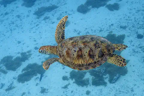
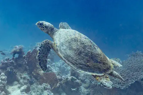
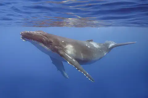
The national park protects nearly 4,000 acres of ocean. Its coral reefs hold more than 900 kinds of fish and more than 230 kinds of coral, and green and hawksbill sea turtles swim there. Humpback whales pass through in the southern winter. The turtle photos here were taken in other places.
The National Park Service describes rainforests rich in endemic plants and animals, including the Samoan fruit bat (flying fox), with banyans, ferns and a dense understory; Pola Island is a nesting site for many seabird species. The park protects nearly 4,000 acres of ocean, where fringing reefs off Tutuila, Ofu and Ta'ū hold over 900 fish species and more than 230 coral species, along with endangered green and hawksbill sea turtles; migrating humpback whales visit in the austral winter.
The park lists coral bleaching, severe storms, invasive species such as the crown-of-thorns starfish, climate change and overfishing as threats, and works with local villages on conservation. The green turtle photo was taken off Moorea, French Polynesia, and the hawksbill photo in Egypt.
Fa'asamoa: the Samoan way
Most people here are Samoan. They speak Samoan and English.
Big families are very important. Each family has a chief, called a matai.
Nearly everyone in American Samoa is Samoan, with family roots going back more than 3,000 years. Most people speak Samoan, and most speak English too. Life follows fa'asamoa, the Samoan way, which puts family, respect for elders and working together first.
An extended family is called an aiga, and each one has a chief, a matai, chosen by the family. The chiefs meet in a village council, the fono, to make decisions. Family land is shared and is not sold outside the family. Many American Samoans have also moved to the United States.
The National Park Service says nearly all inhabitants are Indigenous Samoans, with lineage reaching back over 3,000 years, and describes fa'asamoa as a framework of family (aiga), respect (fa'aaloalo) and community. Each aiga is led by a matai chosen, Britannica adds, by family consensus; the matai of a village form its council (fono), presided over by the highest-ranking ali'i and assisted by tulafale, or talking chiefs. Land is held communally by the aiga and cannot be sold outside the family.
Britannica notes that most Samoans remain fluent in Samoan and that most American Samoans also speak English; both are official. Since the mid-20th century many have migrated to the United States. The 2020 census counted 49,710 people, over 10% fewer than in 2010. Visitors are asked to request permission before taking photos or using a beach in a village, and to wait quietly during sā, the evening prayers at dusk.
Voyagers, a naval station and self-government
Long ago, sailors crossed the ocean in canoes to reach Samoa.
Much later, the United States built a navy station here. Today people vote for their own leaders.
Polynesian voyagers settled the Samoan islands about 3,000 years ago. Many scholars think that later, sailors from Samoa went on to settle much of eastern Polynesia.
A Dutch explorer sighted the islands in 1722. In 1899 an agreement split the Samoan islands: Germany took the western ones, and the United States the eastern ones. The US Navy ran American Samoa for about 50 years. In 1967 it wrote its own constitution, and in 1977 people elected their first governor, Peter Coleman.
Britannica dates Polynesian settlement of the Samoan islands, probably from Tonga, to about 1000 BCE, and notes that many scholars believe Samoa was by about 500 CE the starting point for voyagers who settled much of eastern Polynesia. Jacob Roggeveen sighted Samoa in 1722, and London Missionary Society representatives arrived in the 1830s.
In 1878 the United States signed a treaty for a naval station in Pago Pago Harbor. An 1899 agreement gave Germany the western islands and the United States the eastern ones; local chiefs ceded them by 1904, though Congress accepted the deeds only on 20 February 1929. The Navy administered the territory from 1900 to 1951, when it passed to the Department of the Interior. A constitution followed in 1967, the first elected governor in 1977 and the first nonvoting delegate to the US House in 1981. On 29 September 2009 an undersea earthquake of magnitude 8.3 caused a tsunami that badly damaged Tutuila.
American Samoa on the map
Find New Zealand on the globe.
Now look up and to the right, into the Pacific Ocean. Find the islands of Samoa. The ones farther east are American Samoa.
American Samoa lies in the South Pacific, about 14 degrees south of the equator, between New Zealand to the southwest and Hawaii to the northeast. Samoa is just to the west, across the 171st meridian.
The territory has no land borders. Its islands are too small for the globe to draw, so PlayOwl marks them with dots: Pago Pago on Tutuila, Aunu'u, the Manu'a Islands and Rose Atoll.
American Samoa lies at about 14.3° S, 170.7° W, about 2,600 km northeast of New Zealand and 3,500 km southwest of Hawaii. The 171° W meridian separates it from independent Samoa. It has no land borders.
At the globe's scale its islands have no outlines, so the map uses markers: Pago Pago on Tutuila, Aunu'u, Ofu and Olosega, Ta'ū with Lata Mountain, and Rose Atoll to the east; Swains Island lies about 450 km northwest of Tutuila.
- Land area
- 199 km²
- People (2020 census)
- 49,710
- Rain at Pago Pago
- about 5,000 mm a year
- Distance to Hawaii
- about 3,500 km
Amazing facts
-
Pago Pago Harbor almost cuts its island in two.
Pago Pago Harbor reaches so far into Tutuila that it nearly divides the island in two.
Pago Pago Harbor, the most notable of Tutuila's deep inlets, nearly divides the island in two; the United States signed a treaty for a naval station there in 1878.
-
More than 900 kinds of fish live on the reefs here.
The coral reefs of the National Park of American Samoa are home to more than 900 kinds of fish and more than 230 kinds of coral.
The park's fringing reefs off Tutuila, Ofu and Ta'ū hold over 900 fish species and more than 230 coral species.
-
In the Senate here, chiefs choose the members.
Members of American Samoa's Senate are chosen by councils of chiefs, following Samoan custom, while House members are elected by voters.
The Fono's Senate is chosen by councils of chiefs in accordance with Samoan custom for four-year terms; the House is elected by universal suffrage for two-year terms.
-
Lots and lots of rain falls on Pago Pago.
Pago Pago gets about 5,000 millimeters of rain a year: 5 meters of water, if none of it drained away.
Pago Pago receives about 5,000 mm of rain a year, and the park's highest mountains up to about 7,600 mm.
Words to know
- territory
- an area that belongs to a country but is not one of its states
- US national
- a person who owes loyalty to the United States and may live there, but is not a US citizen
- fa'asamoa
- the Samoan way of life, built on family, respect and community
- matai
- a chief chosen to lead a Samoan extended family
- harbor
- a sheltered area of water where ships can stay safely
- fringing reef
- a coral reef that grows close to the shore of an island
Discovery challenge
-
What covers American Samoa's mountains?
What kind of forest covers American Samoa's mountains?
Which ecosystem, the National Park Service says, covers most of the park's volcanic islands?
- Snow
- Rainforest
- Desert sand
Show the answer
Rainforest
Green rainforest.
Tropical rainforest, with tall ferns and trees.
Tropical rainforest, from the mountaintops down to the coast.
-
What is the Samoan way of life called?
What is the name for the Samoan way of life?
Which word names the Samoan framework of family, respect and community?
- Fa'asamoa
- Aloha
- Siesta
Show the answer
Fa'asamoa
Fa'asamoa, the Samoan way.
Fa'asamoa. It puts family, respect for elders and working together first.
Fa'asamoa, which centers on the aiga, respect (fa'aaloalo) and the matai system.
-
Which country does American Samoa belong to?
American Samoa is a territory of which country?
American Samoa is an unincorporated, unorganized territory of which country?
- New Zealand
- France
- The United States
Show the answer
The United States
The United States.
The United States. Its people are US nationals.
The United States; its people are US nationals, not citizens.
-
What made American Samoa's tall islands?
What built most of American Samoa's islands?
Apart from the atolls, what formed American Samoa's islands within the past seven million years?
- Glaciers
- Volcanoes
- Sand dunes
Show the answer
Volcanoes
Volcanoes made them.
Volcanoes, within the last seven million years.
Volcanic activity, leaving high, rugged interiors.
Places to discover in American Samoa
-
 Watch
City
Pago Pago
Pago Pago is the main town of American Samoa, on the island of Tutuila in the South Pacific. It lies by Pago Pago Harbor, between steep green mountains. The 2020 census counted 3,000 people in the village of Pago Pago.
-
 Watch
Natural wonder
Pacific Ocean
The Pacific Ocean is the largest and deepest ocean basin on Earth, covering more than 30 percent of the planet's surface. It holds more than half of Earth's free water. Its deepest point, Challenger Deep in the Mariana Trench, is nearly 11 kilometers down, and earthquakes and volcanoes ring its edges.
Animals of American Samoa
-
Watch
Animal
Green sea turtle
The green sea turtle is the largest sea turtle with a hard shell. It lives in warm seas around the world and, unlike other sea turtles, grown-ups eat mostly seagrass and algae. Females swim hundreds or even thousands of kilometers to lay their eggs on the beaches where they hatched long ago.
-
 Watch
3D
Animal
Hawksbill sea turtle
The hawksbill sea turtle lives in warm seas around the world, mostly near coral reefs. Its pointed, hawk-like beak reaches into cracks in the reef to find sponges, its favorite food. Its beautiful patterned shell once made it a target for hunters, and today it is critically endangered.
-
 Watch
3D
Animal
Humpback whale
The humpback whale is a baleen whale famous for leaping out of the water, slapping its giant flippers and singing long, complex songs. It lives in every ocean and makes one of the longest journeys of any mammal, between cold feeding waters and warm waters where calves are born. Once hunted almost to extinction, it is now recovering.
Explore next
-
Watch
City
Pago Pago
Pago Pago is the main town of American Samoa, on the island of Tutuila in the South Pacific. It lies by Pago Pago Harbor, between steep green mountains. The 2020 census counted 3,000 people in the village of Pago Pago.
-
 Watch
 Country
Samoa
Samoa is a Polynesian country in the South Pacific, made of nine volcanic islands ringed by coral reefs and lagoons. Most people live in coastal villages and follow the fa'a Samoa, the Samoan way of life. Samoa became independent from New Zealand in 1962, and in 2011 it jumped across the International Date Line. Its 2021 census counted 205,557 people.
-
 Watch
 Country
United States
The United States is a large country in North America made of 50 states, from icy Alaska to the warm islands of Hawaii. It has the Grand Canyon, the Mississippi River and Yellowstone, and about 342 million people live there.
-
 Watch
 Country
Tonga
Tonga is a Polynesian kingdom of about 170 islands in the southwestern Pacific, in three main groups: Tongatapu, Ha'apai and Vava'u. Some islands are volcanoes and others are low coral islands. Captain Cook called them the Friendly Islands. Tonga's 2021 census counted 100,179 people, and the capital is Nuku'alofa.
-
Watch
Natural wonder
Pacific Ocean
The Pacific Ocean is the largest and deepest ocean basin on Earth, covering more than 30 percent of the planet's surface. It holds more than half of Earth's free water. Its deepest point, Challenger Deep in the Mariana Trench, is nearly 11 kilometers down, and earthquakes and volcanoes ring its edges.
-
Watch
Animal
Green sea turtle
The green sea turtle is the largest sea turtle with a hard shell. It lives in warm seas around the world and, unlike other sea turtles, grown-ups eat mostly seagrass and algae. Females swim hundreds or even thousands of kilometers to lay their eggs on the beaches where they hatched long ago.
-
Watch
3D
Animal
Hawksbill sea turtle
The hawksbill sea turtle lives in warm seas around the world, mostly near coral reefs. Its pointed, hawk-like beak reaches into cracks in the reef to find sponges, its favorite food. Its beautiful patterned shell once made it a target for hunters, and today it is critically endangered.
-
Watch
3D
Animal
Humpback whale
The humpback whale is a baleen whale famous for leaping out of the water, slapping its giant flippers and singing long, complex songs. It lives in every ocean and makes one of the longest journeys of any mammal, between cold feeding waters and warm waters where calves are born. Once hunted almost to extinction, it is now recovering.
For parents & teachers
What children will learn
- Locate American Samoa in the South Pacific and tell it apart from the country of Samoa.
- Explain what it means to be a US territory whose people are US nationals.
- Describe fa'asamoa, the aiga and the matai system.
- Describe the rainforests and coral reefs protected by the National Park of American Samoa.
Recommended ages: 3 to 17 · About 15 minutes
Talk about it
- In fa'asamoa, family land is shared and never sold outside the family. What might be good about that, and what might be hard?
- Why might visitors be asked to request permission before taking photos in a village?
- Many families have members in American Samoa and in the United States. How do families stay close when they live far apart?
Try at home or in class
- Measure 5,000 millimeters (5 meters) with a tape measure along a hallway to see how much rain falls on Pago Pago in a year.
- Draw your own extended family tree. How many relatives would be in your aiga?
Key vocabulary: territory, US national, fa'asamoa, matai, harbor, fringing reef
Where these facts come from
- Wikidata , Wikimedia Foundation (CC0 1.0)
- Natural Earth vector data , Natural Earth (NACIS) (Public domain)
- American Samoa (land, climate, plant and animal life, people, economy) , Encyclopaedia Britannica
- American Samoa: government and society , Encyclopaedia Britannica
- American Samoa: history , Encyclopaedia Britannica
- First 2020 Census United States Island Areas Data Released Today , US Census Bureau
- National Park of American Samoa , US National Park Service
- Nature , National Park of American Samoa (US National Park Service)
- People , National Park of American Samoa (US National Park Service)
- Basic information , National Park of American Samoa (US National Park Service)
- PlayOwl region table, version 1 , PlayOwl (PlayOwl original data)
- flag-icons 7.5.0 , Panayiotis Lipiridis and contributors (MIT)
- Wikimedia Commons , Wikimedia Foundation (Per file (public domain, CC0, CC BY or CC BY-SA); see each media record)
Checked, not yet human-reviewed. Last updated November 1, 2026. Spotted a mistake? Tell us.
Picture credits
- Photo: Tavita Togia, National Park Service, public domain, via Wikimedia Commons · source
- Photo: Charles J. Sharp, CC BY-SA 4.0, via Wikimedia Commons · source · license
- Photo: Diego Delso, CC BY-SA 4.0, via Wikimedia Commons · source · license
- Photo: Charles J. Sharp, CC BY-SA 4.0, via Wikimedia Commons · source · license