
 Country
Asia
Philippines
The Philippines is a country made of thousands of islands. It has volcanoes, coral reefs and big, busy cities.
The Philippines is an island country in Southeast Asia, in the western Pacific Ocean. It has more than 7,000 islands, about 50 volcanoes and rich coral reefs, and about 112.7 million people were counted there in 2024.
The Philippines is an archipelago of more than 7,000 islands and islets stretching about 1,850 km from north to south between the Philippine Sea and the South China Sea. Its mountainous, largely volcanic islands are home to nearly 100 ethnic groups and some 150 languages, and the 2024 census counted 112,729,484 people.
Photo: Bro. Jeffrey Pioquinto, SJ, CC BY 2.0, via Wikimedia Commons
Discover the Philippines
The Philippines is a country made of islands.
There are more than 7,000 of them! Some islands are big, and many are tiny. The sea is all around. The capital city is called Manila.
The Philippines is an island country in Southeast Asia, in the western Pacific Ocean, about 800 kilometers off the coast of Vietnam. It is an archipelago, a group of islands: more than 7,000 islands and islets. The largest island is Luzon, in the north, and the second largest is Mindanao, in the southeast.
The capital is Manila, on Luzon, but nearby Quezon City has the most people of any city. In the 2024 census, about 112.7 million people were counted in the Philippines.
The Philippines is an archipelago in the western Pacific, lying about 800 km off the coast of Vietnam. Britannica notes that the islands were long counted as 7,107, but in 2016 the National Mapping and Resource Information Authority announced more than 500 previously uncharted islands. Only about two-fifths of the islands have names, and only some 350 cover 2.6 square kilometers or more.
The large islands fall into three groups: Luzon, Mindoro and Palawan in the north and west; the Visayas in the center, including Cebu, Bohol, Leyte, Negros, Panay and Samar; and Mindanao in the south. Manila is the capital, while Quezon City, also part of Metro Manila on Luzon, is the most populous city. The 2024 Census of Population counted 112,729,484 people on its reference date of July 1, 2024, up from 109.04 million in 2020.
Cities and famous places
Manila is the capital city.
Quezon City is next to it. It has the most people. Cebu City is on another island. Old Spanish towns and churches still stand.
Manila was founded by the Spanish in 1571 and is the capital. It is part of Metro Manila, a huge city area that also includes Quezon City, home to about 3.1 million people in 2024. Cebu City, on the island of Cebu in the Visayas, grew where the Spanish set up their first lasting settlement in 1565.
The town of Vigan, in northwestern Luzon, was started in the 1500s. Its old streets mix ideas from other parts of the Philippines, from China and from Europe. Four churches from the Spanish period, built between the 1500s and the 1700s, are World Heritage Sites too.
Metro Manila, an agglomeration of Quezon City, Manila, Pasay, Caloocan and several other cities and municipalities, is by far the largest urban area in the country; Wikidata gives Quezon City about 3.08 million and Manila about 1.90 million people in 2024. Manila was founded by the Spanish in 1571, six years after Miguel López de Legazpi established the first permanent Spanish settlement on Cebu. Davao on Mindanao and Cebu in the Visayas are the other principal cities.
UNESCO describes Vigan, founded in the 16th century and inscribed in 1999, as the best-preserved example of a planned Spanish colonial town in Asia; its architecture brings together elements from elsewhere in the Philippines, from China and from Europe. Four Baroque churches of the Spanish period, built between the 16th and 18th centuries in Manila, Santa Maria, Paoay and Miag-ao, were inscribed together in 1993; UNESCO describes their style as a reinterpretation of European Baroque by Chinese and Philippine craftsmen.

Volcanoes, lakes and storms
The Philippines has many mountains.
Some mountains are volcanoes. Mount Apo is the tallest one. There are big lakes and long rivers. Big storms called typhoons can blow in from the sea.
Most Philippine islands are mountainous, made mainly of volcanic rock and coral. There are about 50 volcanoes, and the national volcano agency lists 24 as active. The highest mountain is Mount Apo on Mindanao, 2,954 meters tall. Taal Lake, near Manila, fills a volcanic crater, and a volcanic cone rises from its middle.
The weather is tropical: rainy winds blow from the southwest from about May to October, and drier winds come from the northeast from November to February. From June to December, typhoons often strike, though Mindanao is usually free of them. On Palawan, a river runs underground through limestone and comes out straight into the sea.
The islands are composed primarily of volcanic rock and coral, and their mountain ranges mostly run north to south, like the islands. The Sierra Madre along Luzon's Pacific coast is the longest range; the Cordillera Central, averaging about 1,800 m, is the most prominent. Mount Apo, near Mindanao's south-central coast, is the highest peak at 2,954 m. Britannica counts about 50 volcanoes; PHIVOLCS, the national institute of volcanology, lists 24 as active, including Taal, Mayon and Pinatubo, whose 1991 eruption was one of the largest of the 20th century.
Taal Lake occupies 244 km² inside a volcanic crater, and Laguna de Bay (922 km²) is the largest lake. The climate is tropical and strongly monsoonal. Typhoons strike most often from June to December, sometimes 25 or more in a year, heaviest in Samar, Leyte, south-central Luzon and the Batan Islands. At Puerto-Princesa, inscribed by UNESCO in 1999, an underground river crosses a limestone karst landscape and emerges directly into the sea, its lower part rising and falling with the tides.

Animals of the Philippines
The Philippine eagle is a big, rare bird.
It lives on the big islands of Mindanao and Luzon. A small wild buffalo lives on one island. In the sea, coral reefs are full of fish, turtles and sharks.
More than 200 kinds of mammals live in the Philippines, and many of its more than 50 kinds of bats are found only there. The tamaraw, a small wild buffalo, lives only on the island of Mindoro. The Philippine eagle is critically endangered and is found mainly in isolated areas of Mindanao and in the Sierra Madre mountains on Luzon.
The seas are just as rich. Tubbataha Reefs, in the middle of the Sulu Sea, have more than 360 kinds of coral and almost 700 kinds of fish, and whales, dolphins, sharks and sea turtles swim there. On Mount Hamiguitan in Mindanao, eight kinds of plants and animals live nowhere else.
Britannica counts more than 200 mammal species, including pangolins, mouse deer (chevrotains) and civets; the tamaraw (Anoa mindorensis), a small water buffalo, is found only on Mindoro, and many of the more than 50 bat species are peculiar to the Philippines. The Philippine eagle (Pithecophaga jefferyi), which the IUCN's 2025 global assessment lists as Critically Endangered, is limited mainly to isolated areas of Mindanao and the Sierra Madre. Skinks, geckos and snakes are abundant, with more than 100 endemic species, and the milkfish is the national fish.
Tubbataha Reefs Natural Park (inscribed 1993, extended 2009) protects almost 100,000 hectares in the center of the Sulu Sea: three atolls, reef walls dropping more than 100 m, over 360 coral species and almost 700 fish species, with tiger and hammerhead sharks, whales, dolphins and turtles, and one of the few remaining breeding seabird colonies in the region. Mount Hamiguitan Range Wildlife Sanctuary (2014), rising from 75 to 1,637 m, shelters eight species found only there, plus the Philippine eagle and the Philippine cockatoo.
People, languages and food
About 112 million people were counted in the Philippines in 2024.
People speak many languages. Filipino and English are used in schools. Many meals have rice with fish, meat or vegetables.
The people of the Philippines belong to nearly 100 different ethnic groups, and there are about 150 languages. The biggest groups are the Tagalog of Luzon and the Cebuano of the Visayas. Filipino, which is based on Tagalog, and English are the official languages and are used in schools.
Most people are Roman Catholic, and about 5 percent are Muslim, mostly on the southern islands. Many main meals are built around rice or rice noodles, with small amounts of chicken, goat, fish or, in non-Muslim communities, pork, plus fruits and cooked vegetables. Relatives from big extended families often gather for weddings and holidays.
Britannica describes nearly 100 culturally and linguistically distinct ethnic groups; the Tagalog and the Cebuano are each about one-fifth of the population, and the Ilocano and Hiligaynon about one-tenth each. Most of the roughly 150 languages are Austronesian (Western Malayo-Polynesian). Pilipino, or Filipino, based on Tagalog, shares official status with English, the lingua franca and a medium of instruction.
Some four-fifths of people are Roman Catholic and roughly one-tenth belong to other Christian churches; Islam, brought to the south from Brunei in the 15th century, is practiced by about 5 percent, largely on the southern islands. Major meals in most communities center on boiled or steamed rice or rice noodles with small amounts of meat or fish. In Muslim communities of Mindanao and Sulu, the kulintang, a set of suspended gongs with a drum, is still heard at festivals. Especially since World War II, people have moved from rural areas to towns and cities: more than four-fifths of the population was rural at the start of the 20th century, roughly two-fifths by the early 21st.

A long history
People have lived on these islands for a very long time.
Long ago, farmers built rice fields like giant steps on the mountains. Later, the Spanish came and built towns. Now the Philippines is its own country.
People in the mountains of northern Luzon have farmed rice on terraces, steps cut into the slopes, for about 2,000 years. From the 900s the islands had contact with China, and in the 1400s Islam reached the south.
In 1521 an expedition led by Ferdinand Magellan reached Cebu. The Spanish set up their first lasting settlement there in 1565 and founded Manila in 1571, and they ruled for more than 300 years. The islands are named after King Philip II of Spain. Independence was declared on June 12, 1898, and after years under the United States, the Republic of the Philippines began on July 4, 1946.
Archaeological evidence shows that the rice-terrace technique of the Ifugao has been used in the Cordilleras for 2,000 years almost unchanged (UNESCO). Contacts with China from the 10th century produced a community of mixed Filipino-Chinese descent, and Islam arrived in the south from Brunei in the 15th century. Magellan's expedition reached Cebu in March 1521; Legazpi founded the first permanent Spanish settlement there in 1565, Manila followed in 1571, and the Manila galleon trade exchanged Chinese silks for Mexican silver.
In the 1880s the Propaganda Movement, in which José Rizal was a leading figure, called for reform; the Katipunan rose against Spain in 1896, and independence was declared on June 12, 1898. Spain ceded the islands to the United States in the Treaty of Paris (December 1898); fighting between U.S. and Filipino forces broke out, and Aguinaldo, the republic's president, was captured in March 1901. A commonwealth began in 1935; Japan occupied the islands during World War II, and the Republic was proclaimed on July 4, 1946. Ferdinand Marcos declared martial law in 1972; in 1986 the People Power movement led a bloodless uprising that ended his rule, and a new constitution was ratified in 1987.
The Philippines on the map
Find the Philippines on the globe.
It is in Asia, at the edge of the big Pacific Ocean. Its islands make a shape like a triangle. It has no land border with any other country.
The Philippines is in Southeast Asia. Its islands spread out in a rough triangle about 1,850 kilometers from north to south, and together they have a very long coastline, about 36,290 kilometers. Because it is made only of islands, it has no land border with any other country.
Four seas surround it: the Philippine Sea to the east, the Celebes Sea to the south, the Sulu Sea to the southwest and the South China Sea to the west and north. Taiwan lies to the north, and the island of Borneo lies to the south of Palawan.
Britannica describes the archipelago as a triangle: the islands south of Palawan, the Sulu Archipelago and Mindanao form its southern base, and the Batan Islands north of Luzon form its apex. It stretches about 1,850 km from north to south and, at its widest, about 1,130 km from west to east, with a coastline of some 36,290 km. The country has no land boundary.
The Philippine Sea lies to the east, the Celebes Sea to the south, the Sulu Sea to the southwest and the South China Sea to the west and north. Taiwan lies north of the Batan group, the Malaysian part of Borneo is south of Palawan, and the eastern islands of Indonesia lie south and southeast of Mindanao.
- Islands
- more than 7,000 islands and islets
- North to south
- about 1,850 km
- Coastline
- about 36,290 km
- People (2024 census)
- 112,729,484
Amazing facts
-
The Philippines has more than 7,000 islands.
The Philippines was long said to have 7,107 islands, but in 2016 more than 500 new, uncharted islands were announced.
The archipelago was historically counted as 7,107 islands; in 2016 the National Mapping and Resource Information Authority announced more than 500 previously uncharted ones.
-
A river on Palawan flows under the ground.
On the island of Palawan, a river runs underground through limestone and comes out straight into the sea.
Puerto-Princesa's subterranean river crosses a limestone karst landscape and emerges directly into the sea; its lower portion is tidal.
-
A volcano sits in the middle of a lake.
Taal Lake fills a volcanic crater, and a volcanic cone rises from the middle of the lake.
Taal Lake covers 244 km² inside a volcanic crater, with a volcanic cone emerging from its center; PHIVOLCS lists Taal among the country's 24 active volcanoes.
-
A small wild buffalo lives on just one island.
The tamaraw, a small wild buffalo, is found only on the island of Mindoro.
The tamaraw (Anoa mindorensis), a small water buffalo, is found only on Mindoro.
-
Some rice fields are about 2,000 years old.
Rice farmers in the mountains of northern Luzon have used their terrace method for about 2,000 years.
UNESCO notes archaeological evidence that the Ifugao terrace technique has been in use for 2,000 years virtually unchanged.
Words to know
- archipelago
- a group or chain of islands
- volcano
- an opening in Earth's crust where melted rock, ash and gas come out
- typhoon
- a powerful storm that forms over the western Pacific Ocean
- monsoon
- a wind that changes direction with the seasons and brings a rainy season
- atoll
- a ring-shaped coral reef or island around a lagoon
- terrace
- a flat step cut into a hillside so crops can be grown
- World Heritage Site
- a place UNESCO lists as important to all people, to be protected
Discovery challenge
-
What is the capital city of the Philippines?
Which city is the capital of the Philippines?
Which city, founded by the Spanish in 1571, is the capital of the Philippines?
- Cebu City
- Manila
- Davao City
Show the answer
Manila
Manila is the capital of the Philippines.
Manila is the capital. It is on Luzon, next to Quezon City, which has the most people.
Manila was founded by the Spanish in 1571 and is the capital; it is part of Metro Manila with Quezon City, the most populous city.
-
The Philippines is made of many what?
The Philippines has more than 7,000 of what?
The Philippines is an archipelago. An archipelago is a group of what?
- Deserts
- Lakes
- Islands
Show the answer
Islands
The Philippines is made of islands, with the sea all around.
The Philippines has more than 7,000 islands and islets.
An archipelago is a group or chain of islands; the Philippines has more than 7,000 islands and islets.
-
What is the tallest mountain in the Philippines?
Which mountain is the highest in the Philippines?
Which peak, 2,954 meters high near Mindanao's south-central coast, is the country's highest?
- Mount Apo
- Mount Fuji
- Taal Volcano
Show the answer
Mount Apo
Mount Apo is the tallest mountain in the Philippines.
Mount Apo, on Mindanao, is 2,954 meters tall, the highest in the country.
Mount Apo, at 2,954 m, is the highest peak in the Philippines; Taal is a lower volcano in a lake, and Fuji is in Japan.
-
Which big, rare bird lives in the Philippines?
Which critically endangered bird is found mainly on Mindanao and Luzon?
Which critically endangered raptor is limited mainly to isolated areas of Mindanao and the Sierra Madre?
- Philippine eagle
- Emperor penguin
- Ostrich
Show the answer
Philippine eagle
The Philippine eagle is a big, rare bird. It lives on two big islands.
The Philippine eagle is critically endangered and is found mainly in isolated areas of Mindanao and in the Sierra Madre on Luzon.
Pithecophaga jefferyi, the Philippine eagle, is listed by the IUCN as Critically Endangered and is limited mainly to isolated areas of Mindanao and Luzon's Sierra Madre.
-
What is a typhoon?
What is a typhoon, which often strikes the Philippines from June to December?
Typhoons often strike the Philippines from June to December. What is a typhoon?
- A big storm
- A kind of fish
- A mountain
Show the answer
A big storm
A typhoon is a big storm with strong wind and rain.
A typhoon is a powerful storm. In the Philippines they come most often from June to December.
A typhoon is a tropical cyclone of the western Pacific; most reach the Philippines from the southeast, sometimes 25 or more in a year.
Animals of Philippines
-
 Watch
Animal
Philippine eagle
The Philippine eagle is one of the largest and rarest eagles in the world. It lives only in the mountain rainforests of four Philippine islands, where it hunts monkeys, civets, flying squirrels and other forest animals. It is the national bird of the Philippines, and it is critically endangered.
-
 Watch
Animal
Red lionfish
The red lionfish is a striped reef fish with long, spiny fins that spread out like a lion's mane. It comes from the Pacific and eastern Indian Oceans, where it hunts small fish and shrimp at night. People released lionfish into the Atlantic Ocean, and there they have spread fast, eating many native reef fish.
-
 Watch
Animal
Mimic octopus
The mimic octopus is a long-armed, brown-and-white octopus that lives on sandy sea floors in Southeast Asia. Scientists first filmed it in 1998 and were amazed: it changes its shape, colors and movements to look like other animals, including a flatfish, a lionfish and a sea snake.
-
 Watch
3D
Animal
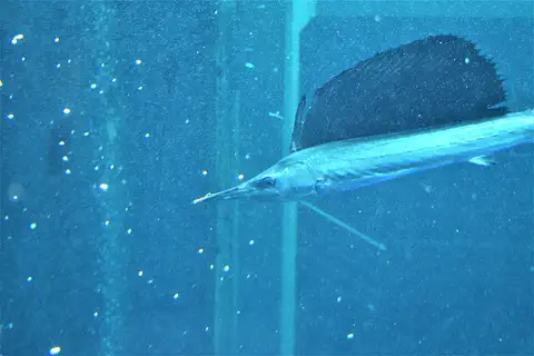
Indo-Pacific sailfish
The sailfish is a long, sleek ocean fish with a tall, sail-like fin on its back and a long, spear-shaped upper jaw called a bill. It hunts schools of small fish in warm seas, folding its sail away to speed up and raising it to make sharp turns.
-
 Watch
Animal
Ocellaris clownfish
The ocellaris clownfish is a small orange-and-white reef fish from the Indian and Pacific Oceans. It shelters among the stinging tentacles of a sea anemone, protected by a slimy coat, and every clownfish starts life as a male.
-
 Watch
Animal
Dugong
The dugong is a large, slow marine mammal that grazes on seagrass meadows in warm, shallow coastal seas from East Africa to the western Pacific. It is a relative of the manatee and, surprisingly, more closely related to elephants than to cows. It has a whale-like tail, a big bristly snout and very good hearing.
-
 Watch
Animal
Reticulated python
The reticulated python lives in the forests, riversides and even towns of Southeast Asia. It can grow longer than any other kind of snake, it is covered in a net-like pattern, and it is such a good swimmer that it has reached many small islands across the sea.
-
 Watch
Animal
Mandarinfish
The mandarinfish is a small, shy fish from the coral reefs of the western Pacific Ocean. It has no scales; instead its skin is covered with slimy mucus and painted with swirling blue, orange and green lines. It hops along the reef bottom on fan-shaped fins, picking up tiny animals, and at dusk males and females rise together to release their eggs.
-
 Watch
Animal
Large flying fox
The large flying fox is a giant fruit bat of Southeast Asia, with wings about 1.5 meters across. It flies out at night to eat fruit, flowers and nectar, spreading seeds and pollinating trees. Because of hunting and forest loss, it is now Endangered.
-
 Watch
3D
Animal
Whale shark
The whale shark is the largest fish in the world. This gentle giant swims through warm seas with its huge mouth open, filtering tiny plankton and small fish from the water, and every whale shark has its own pattern of pale spots.
-
 Watch
Animal
Greater blue-ringed octopus
The greater blue-ringed octopus is a small octopus that lives among rocks and reefs in the western Pacific. Most of the time it hides, but when it is bothered, about 60 blue rings flash on its skin. The bright rings are a warning, and they tell us this is an animal to watch, never to touch.
-
 Watch
3D
Animal
Chambered nautilus
The chambered nautilus is a relative of octopuses and squids that lives inside a coiled shell full of sealed rooms. It moves up and down along deep reef slopes by changing how much gas and water are in its shell, and it finds food mostly by smell.
Explore next
-
Watch
Animal
Philippine eagle
The Philippine eagle is one of the largest and rarest eagles in the world. It lives only in the mountain rainforests of four Philippine islands, where it hunts monkeys, civets, flying squirrels and other forest animals. It is the national bird of the Philippines, and it is critically endangered.
- Watch Geography Why the Ring of Fire exists The Ring of Fire is a horseshoe-shaped path about 40,000 kilometers long around the edges of the Pacific Ocean, with more than 450 volcanoes. It exists because around most of the Pacific, ocean plates are sinking under other plates, which makes magma, deep trenches and earthquakes.
-
Watch
Animal
Red lionfish
The red lionfish is a striped reef fish with long, spiny fins that spread out like a lion's mane. It comes from the Pacific and eastern Indian Oceans, where it hunts small fish and shrimp at night. People released lionfish into the Atlantic Ocean, and there they have spread fast, eating many native reef fish.
-
Watch
Animal
Mimic octopus
The mimic octopus is a long-armed, brown-and-white octopus that lives on sandy sea floors in Southeast Asia. Scientists first filmed it in 1998 and were amazed: it changes its shape, colors and movements to look like other animals, including a flatfish, a lionfish and a sea snake.
-
Watch
3D
Animal
Indo-Pacific sailfish
The sailfish is a long, sleek ocean fish with a tall, sail-like fin on its back and a long, spear-shaped upper jaw called a bill. It hunts schools of small fish in warm seas, folding its sail away to speed up and raising it to make sharp turns.
-
Watch
Animal
Ocellaris clownfish
The ocellaris clownfish is a small orange-and-white reef fish from the Indian and Pacific Oceans. It shelters among the stinging tentacles of a sea anemone, protected by a slimy coat, and every clownfish starts life as a male.
-
Watch
Animal
Dugong
The dugong is a large, slow marine mammal that grazes on seagrass meadows in warm, shallow coastal seas from East Africa to the western Pacific. It is a relative of the manatee and, surprisingly, more closely related to elephants than to cows. It has a whale-like tail, a big bristly snout and very good hearing.
-
Watch
Animal
Reticulated python
The reticulated python lives in the forests, riversides and even towns of Southeast Asia. It can grow longer than any other kind of snake, it is covered in a net-like pattern, and it is such a good swimmer that it has reached many small islands across the sea.
For parents & teachers
What children will learn
- Locate the Philippines and name its three island groups and surrounding seas.
- Describe the country's volcanoes, monsoon seasons and typhoons.
- Describe some of the many peoples, languages and foods of the Philippines without treating them as one culture.
- Outline Philippine history from the rice terraces through Spanish and U.S. rule to the 1946 republic.
Recommended ages: 3 to 17 · About 15 minutes
Talk about it
- How might living on an island change how people travel and trade?
- Why might a country with more than 7,000 islands have so many languages?
- The rice terraces are kept up by whole communities working together. What do people near you look after together?
Try at home or in class
- On a world map, count how many seas surround the Philippines and trace its island groups from north to south.
- Build a set of terraces from damp sand or modeling clay in a tray and gently pour water at the top to see how it flows from step to step.
Key vocabulary: archipelago, volcano, typhoon, monsoon, atoll, terrace, World Heritage Site
Where these facts come from
- Wikidata , Wikimedia Foundation (CC0 1.0)
- Natural Earth vector data , Natural Earth (NACIS) (Public domain)
- UNESCO World Heritage List , UNESCO World Heritage Centre (Linked as a reference; site facts come from Wikidata)
- Philippines Population Hits 112.7 Million (2024 Census of Population, Proclamation 973) , Bernama, reporting the Philippine News Agency
- Proclamation No. 973, s. 2025 (official results of the 2024 Census of Population) , Office of the President of the Philippines, via the LawPhil Project
- 1987 Constitution of the Republic of the Philippines, Article XIV , LawPhil Project (Arellano Law Foundation)
- Philippine eagle (Pithecophaga jefferyi), global assessment 2025 , IUCN Red List of Threatened Species
- Baroque Churches of the Philippines , UNESCO World Heritage Centre
- Philippines (Land, Relief, Drainage, Climate) , Encyclopaedia Britannica
- Philippines: Plant and animal life; People , Encyclopaedia Britannica
- Philippines: Demographic trends , Encyclopaedia Britannica
- Philippines: Cultural life , Encyclopaedia Britannica
- Philippines: The Spanish period , Encyclopaedia Britannica
- Philippines: The 19th century , Encyclopaedia Britannica
- Philippines: The period of U.S. influence , Encyclopaedia Britannica
- Philippines: Martial law , Encyclopaedia Britannica
- Volcanoes of the Philippines , Philippine Institute of Volcanology and Seismology (PHIVOLCS)
- Rice Terraces of the Philippine Cordilleras , UNESCO World Heritage Centre
- Tubbataha Reefs Natural Park , UNESCO World Heritage Centre
- Puerto-Princesa Subterranean River National Park , UNESCO World Heritage Centre
- Historic Town of Vigan , UNESCO World Heritage Centre
- Mount Hamiguitan Range Wildlife Sanctuary , UNESCO World Heritage Centre
- PlayOwl region table, version 1 , PlayOwl (PlayOwl original data)
- flag-icons 7.5.0 , Panayiotis Lipiridis and contributors (MIT)
- Wikimedia Commons , Wikimedia Foundation (Per file (public domain, CC0, CC BY or CC BY-SA); see each media record)
Checked, not yet human-reviewed. Last updated October 24, 2026. Spotted a mistake? Tell us.
Picture credits
- Photo: Bro. Jeffrey Pioquinto, SJ, CC BY 2.0, via Wikimedia Commons · source · license
- Photo: Patrickroque01, CC BY-SA 4.0, via Wikimedia Commons · source · license
- Photo: TheCoffee (Mike Gonzalez), CC BY-SA 3.0, via Wikimedia Commons · source · license
- Photo: Patrickroque01, CC BY-SA 4.0, via Wikimedia Commons · source · license
- Photo: Patrickroque01, CC BY-SA 4.0, via Wikimedia Commons · source · license
- Photo: User: (WT-shared) Naplee12 at wts wikivoyage, CC BY 3.0, via Wikimedia Commons · source · license