 Country
Europe
North Macedonia
North Macedonia is a country in Europe with no sea. It has tall mountains, a very old lake and a river city called Skopje.
North Macedonia is a small, landlocked country in the Balkans of southeastern Europe. It is mostly mountains, the Vardar River runs through its middle, Lake Ohrid has existed for millions of years, and about 1.8 million people lived there in 2023.
North Macedonia is a landlocked, largely mountainous state in the south-central Balkans, at the junction of the Morava–Vardar corridor and old east–west routes between the Black Sea and the Adriatic. Active faults cross it, two tectonic lakes, among them the ancient Lake Ohrid, lie in its southwest, and its State Statistical Office estimated 1,826,247 people in 2023.
Discover North Macedonia
North Macedonia is a country in Europe.
It has no sea. It has tall mountains and green valleys. A river called the Vardar flows through it. The capital city is Skopje.
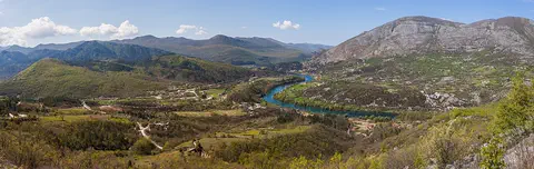
North Macedonia is a small country in the Balkans, the big peninsula in southeastern Europe. It is landlocked, which means it has no sea coast. Most of the land is mountains, with broad, fertile valleys between them.
The Vardar River flows through the middle of the country, and the capital, Skopje, stands on its banks. In the southwest lie two big lakes, Ohrid and Prespa, and Lake Ohrid is very old. About 1.8 million people lived in North Macedonia in 2023, and most of them speak Macedonian or Albanian.
North Macedonia is a landlocked country in the south-central Balkans. It occupies about two-fifths of the wider geographical region of Macedonia; the rest of that region belongs to Greece and Bulgaria. Britannica stresses its position at a junction of routes: the north–south corridor from the Danube to the Aegean along the Morava and Vardar valleys, and the old east–west trade routes linking the Black Sea and Istanbul with the Adriatic.
The land is largely mountainous and is crossed from north to south by active fault lines; about nine-tenths of it drains to the Aegean through the Vardar basin. The 2021 census counted 1,836,713 people, and the State Statistical Office's estimate for 2023 was 1,826,247. Skopje became the capital of the People's Republic of Macedonia within Yugoslavia in 1945 and of the independent state in 1991.
Cities and famous places
Skopje is the biggest city.
A river runs through it. It has wide squares and an old fortress. Ohrid is an old town beside a big blue lake. It has very old churches full of paintings.
Skopje, the capital, stands on the banks of the Vardar River among mountains; about 420,000 people lived in the city in 2021. Its old town lies on the riverbank below an ancient fortress. In 1963 a strong earthquake destroyed much of Skopje. Help came from 78 countries, and from this the city was called the "City of International Solidarity."
Ohrid, on the shore of Lake Ohrid, is one of the oldest human settlements in Europe. Most of its old buildings date from the 600s to the 1800s, and the Ohrid region has more than 800 famous icons, painted pictures made for worship. Bitola, in the south, was a Roman trading town called Heraclea Lyncestis.
Skopje began as Scupi, an Illyrian tribal center, and became the capital of the Roman district of Dardania under Diocletian in the 4th century; an earthquake destroyed it in 518. After conquering Macedonia, the Ottomans made it a provincial capital in 1392. Austrian forces burned it in 1689 to stop a cholera epidemic, and it revived in the 19th century with the Belgrade–Thessaloníki railway. The 1963 earthquake left about 80 percent of the city in ruins; aid arrived from 78 countries, and a new earthquake-resistant town plan followed. The Kuršumli Han, a medieval Turkish inn, survives in the city, and the monastery of Nerezi (1164), with fine 12th-century frescoes, stands nearby.
UNESCO listed the Lake Ohrid region for its nature in 1979 and its culture in 1980, and extended it to the Albanian part of the lake in 2019. Ohrid was built mostly between the 7th and 19th centuries. UNESCO notes the oldest Slav monastery (St. Pantelejmon), more than 800 Byzantine-style icons from the 11th to the 14th centuries, more than 2,500 square meters of frescoes, and seven early Christian basilicas from the 4th to 6th centuries, when the town was called Lychnidos.

Mountains, lakes and moving ground
North Macedonia has many tall mountains.
The tallest is called Korab. Lake Ohrid is a very old lake. It has been there for millions of years. Sometimes the ground shakes in an earthquake.
Many of North Macedonia's peaks rise above the tree line, at about 2,000 meters. The tallest, Mount Korab on the border with Albania, reaches 2,764 meters. The Vardar River and the streams that join it carry water from about nine-tenths of the country southeast to the Aegean Sea.
The ground here moves: active fault lines cross the country, and earthquakes happen often. Movements of Earth's crust also formed Lake Ohrid and Lake Prespa, and Lake Ohrid has existed for about two to three million years. January averages about 0 °C, and July is warm, about 20 to 25 °C.
Geologically, North Macedonia is mainly heavily folded ancient metamorphic rock, eroded in the west to reveal older granites, with younger sedimentary deposits in the center. Active fault lines run north to south; the most severe recent earthquake struck Debar in 1967, and Skopje was largely destroyed in 1963. Crustal movement created the tectonic lakes Prespa and Ohrid, as well as mineral and hot springs. UNESCO describes Lake Ohrid as deep and ancient, in continuous existence for about two to three million years.
The highest point is Korab on the Albanian border: the Parks Dinarides page for Mavrovo National Park gives Veliki Korab 2,764 m, while Britannica gives 2,752 m. About nine-tenths of the country drains to the Aegean through the Vardar; the rest drains north via the Crni Drim toward the Adriatic, often through narrow gorges that suit hydroelectric dams. The climate joins Mediterranean and continental zones, with a cold northerly wind called the vardarec. January averages about 0 °C, July about 20–25 °C, and annual precipitation is only about 500–700 mm, wettest in October and November.
Animals of North Macedonia
Brown bears and wolves live in the mountain forests.
Lynx live there too. Golden eagles fly high above the hills. Lake Ohrid has fish that live nowhere else.
The forests of the mountainous northwest are home to wild pigs, wolves, bears and lynx. In the dry, warm summers there are plenty of insects, especially grasshoppers, and many small lizards. Mavrovo, a national park set up in 1949, is home to the brown bear, the golden eagle and endangered animals such as the lynx, and visitors can also watch for deer and chamois.
Lake Ohrid is a refuge for more than 200 kinds of plants and animals that live only in this lake. They include snails, tiny crustaceans and 17 kinds of fish found nowhere else, two of them trout.
In the mountainous northwest, deciduous woodland on the lower slopes gives way to conifers up to about 2,000 m, and some forest has been cleared for rough summer pasture. Britannica lists wild pigs, wolves, bears and lynx in these forests, and notes that the dry, warm summers bring abundant insects, especially grasshoppers, and numerous small lizards. Mavrovo National Park, declared in 1949 to protect the forest around the Mavrovo valley, records 12 amphibian, 12 reptile, 140 bird and 38 mammal species, including the brown bear, the golden eagle and the endangered lynx, along with wolves, wild boar, deer and chamois.
Lake Ohrid's oligotrophic (nutrient-poor) waters hold more than 200 species found only in the lake, among them algae, turbellarian flatworms, snails, crustaceans and 17 endemic fish, including two species of trout. UNESCO describes many of them as relict species dating from the Tertiary period, and the lake also supports rich birdlife.
People, languages and food
About 1.8 million people live in North Macedonia.
Many speak Macedonian. Many others speak Albanian. People eat burek, a flaky pastry. Ajvar is a sauce made from sweet red peppers.
About 1.8 million people lived in North Macedonia in 2023. In the early 2000s, nearly two-thirds of people described themselves as Macedonians and about a quarter as Albanians, and Turks, Roma, Serbs, Bosniaks and Vlachs live there too. Macedonian, written in the Cyrillic alphabet, is the main official language, and Albanian is official in places where many people speak it.
The food mixes Balkan, Mediterranean and Turkish flavors. Burek is a flaky pastry often filled with cheese, meat or spinach, tavče gravče is baked beans, and ajvar is a sauce of sweet red peppers. Folk music and folk dancing are still popular, along with rock and pop.
The State Statistical Office estimated the population at 1,826,247 in 2023, after the 2021 census counted 1,836,713. Britannica reports that at the start of the 21st century nearly two-thirds of people identified as Macedonians, who generally trace their descent to Slavic tribes that arrived between the 6th and 8th centuries. Albanians, about a quarter of the population in the 2002 census, are concentrated in the northwest and form majorities in some 16 of the 80 municipalities. Smaller minorities include Turks, Roma, Serbs, Bosniaks and Vlachs (Aromani); most Vlachs live in the old mountain town of Kruševo. About three-fifths of the population was urban in the early 21st century.
Macedonian, a Slavic language closely related to Bulgarian and Serbo-Croatian, is written in Cyrillic and was officially recognized only in 1945. A constitutional amendment made Albanian an official language in communities where at least 20 percent speak it. Most Slavic speakers are Orthodox Christians, and about one-third of the population is Muslim. The cuisine joins Balkan and Mediterranean fare with dishes of Turkish origin such as kebapčinja and burek, alongside ajvar, tavče gravče and šopska salata.
A crossroads of history
People have lived here for thousands of years.
Long ago, the Romans built towns here. Later, a big empire ruled the land for about 500 years. In 1991 the people voted to be their own country.
A Stone Age civilization, the Neolithic, flourished here between about 7000 and 3500 BCE. Later the Romans ruled the area and built towns such as Heraclea Lyncestis (now Bitola) and Stobi, and Skopje's name comes from the Roman Scupi. Slavic peoples began to settle in the 500s, and Samuel, a ruler from 976 to 1014, made Ohrid his capital.
By the end of the 1300s the region was part of the Ottoman Empire, which ruled it until 1913. After that the region was divided among Greece, Bulgaria and Serbia, and the part held by Serbia later joined Yugoslavia. In 1945 it became a republic within Yugoslavia, and the Macedonian language was officially recognized. On September 8, 1991, its citizens voted for independence.
Britannica describes a Neolithic civilization here between 7000 and 3500 BCE, followed in the 1st millennium BCE by a mixture of Dacians, Thracians, Illyrians, Celts and Greeks; the kingdom of Philip II and Alexander III in the 4th century BCE is the era most identified with the name Macedonia. Rome subdued the Illyrians in 9 CE. Slavic tribes settled from the mid-6th century, Samuel (reigned 976–1014) set up his capital and a patriarchate at Ohrid, and Stefan Dušan was crowned emperor in Skopje in 1346. By the end of the 14th century the region lay in the Ottoman Empire, which held it until 1913.
In 1903 a revolt against the Ottomans, the Ilinden Uprising, was declared at Kruševo and quickly put down. After the Balkan Wars (1912–13) the region was divided among Greece, Bulgaria and Serbia; the Serbian part joined the Kingdom of Serbs, Croats and Slovenes (Yugoslavia from 1929) and became a Yugoslav republic in 1945. On September 8, 1991, citizens voted for independence, and Britannica notes that the republic was established peacefully. In 2001 an armed conflict between an ethnic Albanian military group and Macedonian security forces ended with the Ohrid Framework Agreement, which included promises to make Albanian an official language and to raise the number of Albanians in the army, police and government. From 1991 Greece objected to the name Macedonia, saying Greeks had used it since ancient times, while the republic answered that Slavs had lived in the area for 14 centuries and had used the name for hundreds of years; the country joined the UN in 1993 under the provisional name "the Former Yugoslav Republic of Macedonia." In June 2018 the two governments announced the Prespa Agreement, under which the country would be known at home and abroad as the Republic of North Macedonia. After both parliaments approved it, the new name took effect on February 12, 2019, and the country joined NATO in March 2020.
North Macedonia on the map
Find North Macedonia on the globe.
It is in Europe, near the south. It has land all around it and no sea. Lake Ohrid sits on its western edge.
North Macedonia is in the south of the Balkans. Its neighbors include Serbia to the north, Bulgaria to the east, Greece to the south and Albania to the west. Lake Ohrid is shared with Albania, and Mount Korab stands on that same border.
The country has no coast, but its rivers reach the sea. Most of them flow into the Vardar, which runs southeast to the Aegean Sea. A few in the west flow north, through the Crni Drim, toward the Adriatic Sea.
Britannica describes North Macedonia as bordered by Kosovo and Serbia to the north, Bulgaria to the east, Greece to the south and Albania to the west. The republic covers the northern part of the historical region of Macedonia, about two-fifths of it; the rest lies in Greece and Bulgaria, and most people with a Macedonian identity call these three parts Vardar, Aegean and Pirin Macedonia.
The wider region is traditionally bounded by the Aegean Sea and the Aliákmon River in the south; by Lakes Prespa and Ohrid, the watershed west of the Crni Drim and the Šar Mountains in the west; by the Skopska Crna Gora mountains and the Morava–Vardar watershed in the north; and by the Pirin Mountains in the east. The country's area is about 25,700 km². The Vardar drains about nine-tenths of it to the Aegean, and Korab, the highest point, stands on the Albanian border.
- Coastline
- none (landlocked)
- Share of the wider region of Macedonia
- about two-fifths
- Land drained by the Vardar to the Aegean
- about nine-tenths
- Highest point (Mavrovo National Park)
- Veliki Korab, 2,764 m
- People (State Statistical Office estimate, 2023)
- 1,826,247
Amazing facts
-
Lake Ohrid has fish that live nowhere else.
Lake Ohrid has 17 kinds of fish that live nowhere else in the world, including two kinds of trout.
Lake Ohrid holds more than 200 endemic species, including 17 endemic fish, two of them trout species.
-
People from many countries helped Skopje after an earthquake.
After an earthquake destroyed much of Skopje in 1963, help came from 78 countries, so it was called the "City of International Solidarity."
The 1963 earthquake left some 80 percent of Skopje in ruins; relief from 78 countries gave it the name "City of International Solidarity," and it was rebuilt to an earthquake-resistant plan.
-
Ohrid has hundreds of very old paintings.
The Ohrid region has more than 800 famous icons, some painted more than 900 years ago.
UNESCO counts more than 800 Byzantine-style icons from the 11th to the 14th centuries and more than 2,500 square meters of frescoes in the Ohrid region.
-
Most of the rivers flow into one big river.
The Vardar River and the streams that join it drain about nine-tenths of North Macedonia.
About nine-tenths of North Macedonia drains southeast to the Aegean through the Vardar basin; the remainder drains north via the Crni Drim toward the Adriatic.
-
A big park in the mountains keeps bears safe.
Mavrovo National Park was set up in 1949, and it is home to brown bears, golden eagles and lynx.
Mavrovo National Park, declared in 1949, records 38 mammal and 140 bird species, among them the brown bear, golden eagle and the endangered lynx.
Words to know
- landlocked
- surrounded by land, with no coast on a sea or ocean
- fault line
- a crack in Earth's crust where blocks of rock can move, causing earthquakes
- tectonic lake
- a lake that fills a hollow made by movements of Earth's crust
- endemic
- found naturally in only one place in the world
- Cyrillic
- an alphabet used to write Macedonian and several other languages
- icon
- a painted picture, often on wood, made for Orthodox Christian worship
- census
- an official count of all the people living in a country
Discovery challenge
-
What is the capital city of North Macedonia?
Which city is the capital of North Macedonia?
Which city, the Roman Scupi, is the capital of North Macedonia?
- Ohrid
- Skopje
- Bitola
Show the answer
Skopje
Skopje is the capital. A river runs through it.
Skopje is the capital, on the banks of the Vardar River. Ohrid and Bitola are other towns.
Skopje grew from Roman Scupi and has been the capital since 1945; Bitola was Roman Heraclea Lyncestis, and Ohrid stands on Lake Ohrid.
-
North Macedonia has no sea. What do we call a country like that?
North Macedonia has no sea coast. What is a country with no coast called?
Which term describes a country, like North Macedonia, with no coastline?
- An island
- A peninsula
- Landlocked
Show the answer
Landlocked
It is landlocked. It has land all around it.
A landlocked country has land on every side and no sea coast, like North Macedonia.
North Macedonia is landlocked; its rivers still reach the sea, mostly via the Vardar to the Aegean.
-
Lake Ohrid is very old. How old is it?
About how long has Lake Ohrid existed?
According to UNESCO, for about how long has Lake Ohrid existed continuously?
- About 2 to 3 million years
- About 100 years
- About 1,000 years
Show the answer
About 2 to 3 million years
Lake Ohrid is millions of years old.
Lake Ohrid has existed for about two to three million years, and many of its animals live nowhere else.
UNESCO describes Lake Ohrid as a deep, ancient tectonic lake in continuous existence for about two to three million years.
-
What is the tallest mountain in North Macedonia?
Which mountain is the highest in North Macedonia?
Which peak on the Albanian border is North Macedonia's highest point?
- Mount Everest
- Mount Korab
- Mount Kilimanjaro
Show the answer
Mount Korab
Mount Korab is the tallest. It is very high.
Mount Korab, 2,764 meters, is the highest. It is on the border with Albania.
Korab, on the Albanian border, is the highest point: 2,764 m according to Mavrovo National Park, 2,752 m according to Britannica.
-
Which big river flows through Skopje?
Which river flows through Skopje and drains most of North Macedonia?
Which river basin drains about nine-tenths of North Macedonia to the Aegean?
- The Vardar
- The Nile
- The Amazon
Show the answer
The Vardar
The Vardar flows through Skopje.
Skopje stands on the Vardar, which carries water from about nine-tenths of the country to the Aegean Sea.
About nine-tenths of the country drains through the Vardar basin to the Aegean; the rest drains north via the Crni Drim.
Animals of North Macedonia
-
 Watch
3D
Animal
Brown bear
The brown bear lives in more places than any other bear, from European forests to the mountains of Asia and the rivers of Alaska. It eats almost anything, from berries to salmon, and spends the long winter asleep in a cozy den. Grizzly bears and Kodiak bears are brown bears too.
-
 Watch
Animal
Eurasian lynx
The Eurasian lynx is the largest of the four kinds of lynx. It has black ear tufts, a ruff of fur around its face, a short black-tipped tail and big furry paws for snow. It hides in forests and ambushes deer such as roe deer, and it has returned to parts of Europe where it had disappeared.
-
 Watch
3D
Animal
Gray wolf
The gray wolf is the largest member of the dog family and the wild ancestor of pet dogs. Wolves live in family packs that hunt big animals like elk and moose together, and their howls can carry about 10 kilometers. After being wiped out in many places, wolves are coming back in parts of North America and Europe.
-
 Watch
Animal
Golden eagle
The golden eagle is one of the largest and fastest birds of prey in North America, and it lives across much of the Northern Hemisphere. It soars over mountains and open country on wings more than two meters wide and dives at tremendous speed to catch rabbits, hares and ground squirrels.
Explore next
-
Watch
3D
Animal
Brown bear
The brown bear lives in more places than any other bear, from European forests to the mountains of Asia and the rivers of Alaska. It eats almost anything, from berries to salmon, and spends the long winter asleep in a cozy den. Grizzly bears and Kodiak bears are brown bears too.
-
Watch
Animal
Eurasian lynx
The Eurasian lynx is the largest of the four kinds of lynx. It has black ear tufts, a ruff of fur around its face, a short black-tipped tail and big furry paws for snow. It hides in forests and ambushes deer such as roe deer, and it has returned to parts of Europe where it had disappeared.
-
Watch
3D
Animal
Gray wolf
The gray wolf is the largest member of the dog family and the wild ancestor of pet dogs. Wolves live in family packs that hunt big animals like elk and moose together, and their howls can carry about 10 kilometers. After being wiped out in many places, wolves are coming back in parts of North America and Europe.
-
Watch
Animal
Golden eagle
The golden eagle is one of the largest and fastest birds of prey in North America, and it lives across much of the Northern Hemisphere. It soars over mountains and open country on wings more than two meters wide and dives at tremendous speed to catch rabbits, hares and ground squirrels.
- Watch Geography Earthquakes and faults Earthquakes happen when rocks suddenly slip along a crack in the Earth called a fault. The slip sends waves of shaking through the ground. Seismometers record the waves so scientists can find where an earthquake happened and how big it was, and engineers design buildings to stay standing.
-
 Watch
 Country
Belarus
Belarus is a landlocked country in eastern Europe. Ice sheets of the last ice age shaped its low hills and wide plains, it has more than 10,000 lakes and one of Europe's largest wetlands, and about 9.1 million people lived there in 2025.
-
 Watch
 Country
Bosnia and Herzegovina
Bosnia and Herzegovina is a mountainous country in southeastern Europe. It has forests, limestone hills and many rivers, and famous old stone bridges cross some of them. Its capital is Sarajevo. It touches the Adriatic Sea along only about 20 kilometers of coast.
-
 Watch
 Country
Bulgaria
Bulgaria is a country on the eastern side of the Balkan Peninsula, with the Danube River to the north and the Black Sea to the east. Mountains cross it from west to east, and about 6.4 million people lived there at the end of 2025.
For parents & teachers
What children will learn
- Locate North Macedonia in the Balkans and explain what landlocked means.
- Describe how moving crust gives the country earthquakes and its tectonic lakes, Ohrid and Prespa.
- Name some of its wildlife, languages and foods without treating its people as one single culture.
- Outline its history from Roman towns and Ottoman rule to independence in 1991.
Recommended ages: 3 to 17 · About 15 minutes
Talk about it
- Why might a country with no coast still care about the seas its rivers flow into?
- Skopje was rebuilt with help from 78 countries. When have people helped each other after a disaster?
- Why do you think so many plants and animals in Lake Ohrid live nowhere else?
Try at home or in class
- On a map, trace the Vardar River from Skopje to the Aegean Sea and count the countries it passes through.
- Fill a tray with damp sand, tilt it gently and pour a little water at the top to see how streams join into one river.
Key vocabulary: landlocked, fault line, tectonic lake, endemic, Cyrillic, icon, census
Where these facts come from
- Wikidata , Wikimedia Foundation (CC0 1.0)
- Natural Earth vector data , Natural Earth (NACIS) (Public domain)
- UNESCO World Heritage List , UNESCO World Heritage Centre (Linked as a reference; site facts come from Wikidata)
- North Macedonia (introduction, land, drainage, climate, plant and animal life) , Encyclopaedia Britannica
- North Macedonia: People , Encyclopaedia Britannica
- North Macedonia: Cultural life , Encyclopaedia Britannica
- North Macedonia: History , Encyclopaedia Britannica
- North Macedonia: The Ottoman Empire , Encyclopaedia Britannica
- North Macedonia: Independence , Encyclopaedia Britannica
- Skopje , Encyclopaedia Britannica
- Natural and Cultural Heritage of the Ohrid region , UNESCO World Heritage Centre
- Population (key indicators) , State Statistical Office of the Republic of North Macedonia
- National park Mavrovo , Parks Dinarides (network of protected areas of the Dinarides)
- PlayOwl region table, version 1 , PlayOwl (PlayOwl original data)
- flag-icons 7.5.0 , Panayiotis Lipiridis and contributors (MIT)
Checked, not yet human-reviewed. Last updated October 24, 2026. Spotted a mistake? Tell us.