
 Country
North America
Panama
Panama is a thin strip of land between two oceans. Big ships sail right across it on a canal. Sloths and monkeys live in its rainforests.
Panama is a narrow country in Central America that joins North and South America. Since 1914 the Panama Canal has let ships cross from the Atlantic Ocean to the Pacific without sailing around South America. Panama has rainforests, more than 1,600 islands and about 4.6 million people (2025).
Panama occupies the Isthmus of Panama, the narrow land bridge between North and South America, plus more than 1,600 islands. The 80-kilometer Panama Canal, opened in 1914 and run by Panama since the end of 1999, lifts ships through a chain of locks across its middle. The land bridge also let plants and animals move between the continents, giving Panama remarkably varied wildlife. Its population was 4.57 million in 2025 (World Bank).
Photo: Stan Shebs, CC BY-SA 3.0, via Wikimedia Commons
Discover Panama
Panama is a thin country.
It joins North America and South America like a bridge. The sea is on both sides. Big ships cross Panama on a canal. The capital is Panama City.
Panama is a country in Central America shaped like a long, wiggly S. It sits on the Isthmus of Panama, a narrow bridge of land that connects North America and South America. The Caribbean Sea lies to the north and the Pacific Ocean to the south.
Panama is famous for the Panama Canal, a waterway that cuts through the middle of the country so ships can travel between the two oceans. Its capital, Panama City, stands on the Pacific coast just east of the canal. About 4.6 million people lived in Panama in 2025, and Spanish is the official language.
Panama stretches in an elongated S across the Isthmus of Panama, between the Caribbean Sea to the north and the Pacific Ocean to the south. Its Caribbean coastline runs for some 1,290 km and its Pacific coastline for some 1,700 km, yet a straight line from the Costa Rican border to the Colombian border is only about 770 km. At its narrowest the isthmus is about 50 km across, and the canal crosses a section nearly as narrow.
Britannica calls Panama one of the world's most strategic transportation hubs because of the canal, which Panama has controlled entirely since the United States gave up jurisdiction on December 31, 1999. Panama City, the capital, is a commercial, financial and logistics center for Latin America. The World Bank put the population at 4,571,189 in 2025; Spanish is the official language and the balboa is the monetary unit, used alongside the United States dollar.

The canal and famous places
The Panama Canal is a road of water for ships.
Water steps called locks lift the ships up and down. A long bridge crosses the canal. Panama City has very tall buildings.
The Panama Canal is about 80 kilometers long. Ships cannot simply float across, because the middle of the canal is a lake 26 meters above the sea. So the canal uses locks: giant chambers with gates that fill with water and lift a ship up like an elevator, then lower it on the other side. The water comes from Gatun Lake and flows into the locks by gravity.
Between 13,000 and 14,000 ships use the canal every year. Near Panama City, the Bridge of the Americas, opened in 1962, carries a road high over the canal's Pacific entrance. On the Caribbean coast, old Spanish forts at Portobelo and San Lorenzo once guarded the trade route to Spain.
The Panama Canal Authority describes a waterway of about 80 km whose locks act as water lifts, raising ships from sea level to Gatun Lake, 26 m above sea level, and lowering them again. Each set of locks takes the name of the town where it was built: Gatún on the Atlantic side, Pedro Miguel and Miraflores on the Pacific. The original chambers are 33.53 m wide and 304.8 m long, and the water that fills them drains from Gatun Lake by gravity. The narrowest stretch, the Culebra Cut, runs about 13.7 km through rock of the Cordillera Central. New, larger locks, Agua Clara and Cocolí, opened on June 26, 2016. Between 13,000 and 14,000 ships transit each year.
The Bridge of the Americas (1962) spans the Pacific entrance. UNESCO lists the fortifications of Portobelo and San Lorenzo (1980), Spanish military architecture of the 17th and 18th centuries that protected the Caribbean ends of the route across the isthmus; they have been on the List of World Heritage in Danger since 2012.
Rainforests, islands and two coasts
Panama is warm all year.
It has rainforests, beaches and coral reefs. More than 1,600 islands lie off its coasts. Its tallest mountain is an old volcano.
Mountains run along almost the whole length of Panama. Its highest peak, Volcán Barú, is an inactive volcano 3,475 meters tall. It is warm all year: on both coasts, the average temperature of the coldest month rarely drops below 26 °C.
The Caribbean side gets rain almost all year and is covered in rainforest. The Pacific side has a dry season, from January to April in Chiriquí province, and more grassy savanna. Panama also has mangrove swamps, coral reefs and more than 1,600 islands. Coiba, the largest, is a national park where UNESCO counts 760 kinds of sea fish.
A central spine of mountains, the Tabasará Mountains (Cordillera Central) in the west and the Cordillera de San Blas in the east, divides Panama into Caribbean- and Pacific-facing slopes; the lower saddle between them is where the canal was built. The highest peak, Barú (Chiriquí), is an inactive volcano 3,475 m high. Facing the trade winds, the Caribbean slopes receive about twice as much rain as the Pacific slopes, 1,500–3,550 mm a year against 1,140–2,290 mm, and carry tropical rainforest, while savannas cover the seasonally dry Pacific lowlands.
National parks and reserves occupy about one-sixth of the land. Darién National Park (UNESCO, 1981), about 575,000 ha, is Panama's largest protected area and runs along almost the whole border with Colombia; it holds the most extensive lowland rainforest on Central America's Pacific coast. Coiba National Park (UNESCO, 2005) protects Coiba and 38 smaller islands; UNESCO records 760 species of marine fishes, 33 of sharks and 20 of whales and dolphins there.

Animals of Panama
Sloths hang from the trees in Panama.
Monkeys and jaguars live in the forests. A huge eagle called the harpy eagle lives there too. Sea turtles lay eggs on the beaches.
Panama's land bridge joined two continents, and animals walked across it. That is why sloths, anteaters and armadillos, which came from South America, now live alongside jaguars, tapirs and deer, which came from North America. Several kinds of sea turtle lay their eggs on Panama's beaches, and it has a huge number of bird species.
In the Darién rainforest live giant anteaters, Central American tapirs, jaguars and an important population of harpy eagles, one of the biggest eagles in the world. The Panamanian golden frog is native to Panama's forests, but none has been seen in the wild since 2009, and zoos now care for golden frogs.
Britannica explains Panama's rich fauna by its ancient role as a land bridge: sloths, anteaters and armadillos derive from South America, while jaguars, tapirs and deer came originally from North America. Several species of giant sea turtle nest on its beaches, and few comparable areas have more bird species, resident and migratory. UNESCO records 169 mammal species and more than 530 bird species in Darién National Park, including the critically endangered brown-headed spider monkey, the endangered Central American tapir, the vulnerable giant anteater and a major population of the near-threatened harpy eagle.
The Panamanian golden frog (Atelopus zeteki), native to streams on the slopes of west-central Panama, is classed as critically endangered. The Smithsonian's National Zoo reports that chytridiomycosis, a fungal disease, wiped out populations such as those at El Copé in late 2004, and no golden frog has been seen in the wild since 2009; zoos keep an assurance population while researchers look for ways to fight the fungus.

People, languages and food
About 4.6 million people live in Panama.
Most people speak Spanish. Some speak their own Indigenous languages. Rice, beans and corn are favorite foods. Guna women sew bright pictures called molas.
About 4.6 million people lived in Panama in 2025. Most have mixed Indigenous and European ancestors, and many Afro-Panamanians descend from Caribbean families who came to build the canal. In the 2023 census, about 17 out of every 100 people belonged to one of eight Indigenous peoples, such as the Ngäbe, Guna and Emberá.
Spanish is the official language, and many people also learn English at school. Rice, beans and corn are everyday foods, and arroz con pollo and sancocho, both chicken dishes, are favorites. Guna women make bright molas, cloth panels decorated with layers of cut fabric.
People of mixed Indigenous and European ancestry form the largest part of the population. Afro-Panamanians, descended from Africans brought in the colonial period and from later Caribbean migrants, many of whom came to build the canal, live mainly in cities, on the Caribbean coast, in Darién and along the canal corridor. The 2023 census counted about 698,000 Indigenous people, roughly 17 percent of the total, in eight recognized peoples: the Ngäbe, Buglé, Guna, Emberá, Wounaan, Naso Tjër Di, Bribri and Bokota, many living in legally recognized territories called comarcas. Panama is also home to Chinese, South Asian and Middle Eastern communities and a long-standing Jewish community.
Spanish is official and spoken by the great majority; English is widely taught. Rice, beans and corn are staples, flavored with chiles and the herb culantro, and arroz con pollo and sancocho are national favorites. Guna women's molas use reverse appliqué, and the national dance, the tamborito, has couples moving to drumbeats. More than half the population lives near the canal.
From Spanish trails to the canal
Long ago, only Indigenous peoples lived in Panama.
Then Spanish ships came. People carried treasure across the land. Later, workers built the canal. In 1999, Panama took charge of its canal.
Indigenous peoples lived in Panama long before Spanish ships arrived in the 1500s. Panama City was founded in 1519. For hundreds of years, gold and silver bound for Spain were carried across the narrow land, and forts like Portobelo guarded the route.
In 1821 Panama broke away from Spain and joined Gran Colombia. Later, a railroad across the isthmus helped travelers rushing to the California gold fields. France tried to dig a canal from 1880 but gave up. On November 3, 1903, Panama declared independence, and the United States built the canal, which opened on August 15, 1914. The United States ran it until December 31, 1999, when Panama took full control.
The isthmus was home to Indigenous peoples such as the Guaymí (Ngäbe), Kuna (Guna) and Chocó when Spain made it its first colony on the Pacific; Panama City was founded in 1519. In the 1530s it was the staging point for the Spanish conquest of the Inca empire, and until the 19th century gold and silver crossed it on the way to Spain. UNESCO notes that this colonial route, which it inscribed in 2025, was not a peaceful process: it involved Indigenous peoples, enslaved Africans and European colonizers.
In 1821 Panama seceded from Spain and joined Gran Colombia. Ferdinand de Lesseps's French company began a canal in 1880 but collapsed by 1889. After Colombia's senate rejected the Hay-Herrán Treaty, a junta proclaimed independence on November 3, 1903, and the Hay–Bunau-Varilla Treaty gave the United States control of a Canal Zone 16 km wide. The canal opened on August 15, 1914. The Torrijos-Carter Treaties, signed in 1977 and ratified by the U.S. Senate in 1978, gave Panama eventual control; Omar Torrijos, who signed them for Panama, had come to power in a 1968 coup. In December 1989 U.S. forces invaded Panama to remove its leader, Manuel Noriega, from power, and on December 31, 1999, the United States relinquished jurisdiction over the canal. Today Panama is a multiparty republic; José Raúl Mulino is president (2026).

Panama on the map
Find Panama on the globe.
It is a thin strip of land. North America is on one side. South America is on the other side.
Panama is the narrow link between North and South America. Costa Rica lies to the west and Colombia, in South America, lies to the east. The Caribbean Sea, part of the Atlantic Ocean, is to the north, and the Pacific Ocean is to the south.
At its narrowest, Panama is only about 50 kilometers wide. The canal crosses near the middle of the country, splitting it into a western half and an eastern half.
Panama borders Costa Rica to the west and Colombia to the east, with the Caribbean Sea, an arm of the Atlantic, to the north and the Pacific Ocean to the south. Its mountain spine divides Caribbean and Pacific slopes, and the low saddle crossed by the canal divides the country again into western and eastern halves; most people and businesses are clustered near the canal.
The Pacific coast is more indented, with the Azuero Peninsula and the Gulf of Panama, and has a much wider continental shelf. Most of the more than 1,600 islands lie on the Pacific side, including the Pearl Islands, Taboga and Coiba, the largest; the main Caribbean island groups are Bocas del Toro and San Blas.
- Caribbean coastline
- about 1,290 km
- Pacific coastline
- about 1,700 km
- Narrowest point
- about 50 km across
- Panama Canal
- about 80 km long
- People (2025)
- 4,571,189
Amazing facts
-
Water for the canal locks comes from a lake.
The Panama Canal's locks fill with water that flows down from Gatun Lake by gravity.
The Panama Canal Authority explains that the water used to raise and lower ships in each set of locks drains from Gatun Lake by gravity through channels under the chambers.
-
Golden frogs from Panama now live in zoos.
No Panamanian golden frog has been seen in the wild since 2009, so zoos care for them while scientists fight the disease that harmed them.
Chytridiomycosis, caused by the amphibian chytrid fungus, wiped out wild Panamanian golden frogs; none has been seen in the wild since 2009, and zoos keep an assurance population.
-
Panama has more than 1,600 islands.
Panama has more than 1,600 islands, and most of them are on the Pacific side.
Most of Panama's more than 1,600 islands lie off the Pacific coast, including the Pearl Islands and Coiba, the largest.
-
Coiba's sea has lots and lots of fish.
UNESCO counts 760 kinds of sea fish, 33 kinds of sharks and 20 kinds of whales and dolphins in Coiba National Park.
Coiba National Park and its Special Zone of Marine Protection hold 760 species of marine fishes, 33 shark species and 20 cetacean species, according to UNESCO.
-
Sloths in Panama came from South America long ago.
Sloths, anteaters and armadillos came into Panama from South America, while jaguars, tapirs and deer came from North America.
Britannica credits Panama's mix of wildlife to its ancient role as a land bridge: sloths, anteaters and armadillos derive from South America, jaguars, tapirs and deer from North America.
Words to know
- isthmus
- a narrow strip of land with water on both sides that joins two larger pieces of land
- canal
- a waterway dug by people for boats and ships
- lock
- a chamber with gates where water is raised or lowered to lift or lower a boat
- rainforest
- a thick forest that gets a lot of rain all year
- mola
- a bright cloth panel made by Guna women from layers of cut fabric
- Indigenous
- describes the first peoples known to have lived in a place
- World Heritage Site
- a place UNESCO lists as important to all people, to be protected
Discovery challenge
-
What do big ships use to cross Panama?
What waterway lets ships cross Panama from one ocean to the other?
Which waterway, opened in 1914, links the Atlantic and Pacific across Panama?
- A canal
- A glacier
- A desert road
Show the answer
A canal
Ships cross Panama on the Panama Canal.
The Panama Canal, about 80 kilometers long, lets ships travel between the Atlantic and Pacific.
The Panama Canal opened on August 15, 1914, and Panama has controlled it fully since December 31, 1999.
-
Panama joins North America and which other land?
The Isthmus of Panama connects North America with which continent?
The Isthmus of Panama is the land bridge between North America and which continent?
- Africa
- South America
- Europe
Show the answer
South America
Panama joins North America and South America.
Panama is a narrow land bridge between North and South America.
The isthmus joins the two Americas, which is why animals from both continents live in Panama.
-
What lifts the ships up in the canal?
What do the canal's locks use to lift ships up to Gatun Lake?
The canal's locks raise ships 26 meters to Gatun Lake using what?
- Water
- Balloons
- Giant wheels
Show the answer
Water
Water fills the locks and lifts the ships.
The locks fill with water, which lifts the ships 26 meters, like an elevator.
Water drains from Gatun Lake into the chambers by gravity, raising and lowering ships.
-
Which slow animal hangs in Panama's trees?
Which slow animal, whose family came from South America, lives in Panama's forests?
Which animal group came into Panama from South America across the land bridge?
- Polar bear
- Camel
- Sloth
Show the answer
Sloth
Sloths hang in the trees in Panama.
Sloths came from South America and live in Panama's forests today.
Britannica names sloths, anteaters and armadillos as animals that derive from South America.
-
When did Panama take charge of its canal?
In which year did Panama take full control of the canal?
On December 31 of which year did the United States hand over jurisdiction of the canal?
- 1914
- 1999
- 2016
Show the answer
1999
Panama took charge of its canal in 1999.
Panama took full control of the canal on December 31, 1999.
Under the Torrijos-Carter Treaties of 1977, the United States relinquished jurisdiction on December 31, 1999.
Animals of Panama
-
Watch
3D
Animal
Harpy eagle
Harpy eagles are among the largest and most powerful eagles in the world. They live in the lowland rainforests of Central and South America, where they hunt sloths and monkeys in the treetops. Forest loss and shooting have made them rare.
-
 Watch
Animal
Brown-throated sloth
The brown-throated sloth is a three-toed sloth of the rainforests of Central and South America. It eats leaves, saves energy by moving very slowly, and its shaggy fur can turn green with tiny algae that grow in it.
-
 Watch
Animal
Panamanian golden frog
The Panamanian golden frog is a small, bright yellow toad with black patches from the forest streams of Panama. Males wave their arms to talk to each other. A disease caused by the chytrid fungus wiped out the wild frogs, and none has been seen in the wild since 2009, so zoos and scientists are caring for golden frogs and working to return them to nature one day.
-
 Watch
Animal
Army ant
Army ants hunt together in giant swarms and never build a permanent nest. This page is about the best-studied kind, Eciton burchellii, of Central and South American forests. Each night of its traveling phase the colony moves, and the workers link their legs to build a living camp around their queen and young.
-
 Watch
Animal
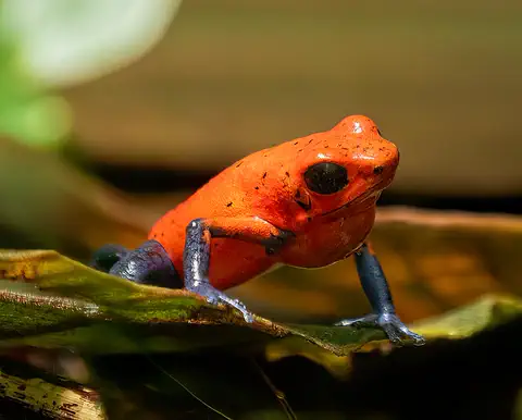
Strawberry poison frog
The strawberry poison frog is a tiny frog of the rainforest floor in Nicaragua, Costa Rica and Panama. Its bright colors warn hunters that its skin is poisonous, and its parents take amazing care of their young: the mother carries each tadpole to its own little pool and feeds it eggs.
-
 Watch
Animal
Common basilisk
The common basilisk is a lizard of riversides and streams from Nicaragua to Venezuela. It climbs trees, swims well and, when it is startled, can sprint upright across the surface of the water on its big back feet before it sinks and swims.
-
 Watch
Animal
Red-eyed tree frog
The red-eyed tree frog lives in the rainforests of Central America. By day it sleeps folded up on a leaf, looking plain green. When something disturbs it, it flashes huge red eyes, orange feet and blue-and-yellow sides.
Explore next
-
 Watch
 Country
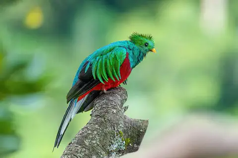
Costa Rica
Costa Rica is a small country in Central America between the Caribbean Sea and the Pacific Ocean. Volcanoes and mountains run down its middle, its forests are full of wildlife, and many national parks protect them. Since 1949 it has had no army. About 5.2 million people lived there in 2025.
-
Watch
3D
Animal
Harpy eagle
Harpy eagles are among the largest and most powerful eagles in the world. They live in the lowland rainforests of Central and South America, where they hunt sloths and monkeys in the treetops. Forest loss and shooting have made them rare.
-
Watch
Animal
Brown-throated sloth
The brown-throated sloth is a three-toed sloth of the rainforests of Central and South America. It eats leaves, saves energy by moving very slowly, and its shaggy fur can turn green with tiny algae that grow in it.
-
Watch
Animal
Panamanian golden frog
The Panamanian golden frog is a small, bright yellow toad with black patches from the forest streams of Panama. Males wave their arms to talk to each other. A disease caused by the chytrid fungus wiped out the wild frogs, and none has been seen in the wild since 2009, so zoos and scientists are caring for golden frogs and working to return them to nature one day.
-
Watch
Animal
Army ant
Army ants hunt together in giant swarms and never build a permanent nest. This page is about the best-studied kind, Eciton burchellii, of Central and South American forests. Each night of its traveling phase the colony moves, and the workers link their legs to build a living camp around their queen and young.
-
Watch
Animal
Strawberry poison frog
The strawberry poison frog is a tiny frog of the rainforest floor in Nicaragua, Costa Rica and Panama. Its bright colors warn hunters that its skin is poisonous, and its parents take amazing care of their young: the mother carries each tadpole to its own little pool and feeds it eggs.
-
Watch
Animal
Common basilisk
The common basilisk is a lizard of riversides and streams from Nicaragua to Venezuela. It climbs trees, swims well and, when it is startled, can sprint upright across the surface of the water on its big back feet before it sinks and swims.
-
Watch
Journey
Building the Panama Canal
Before the Panama Canal, ships going between the Atlantic and Pacific had to sail around the tip of South America. A French company tried to dig a canal across Panama in the 1880s but failed. The United States took over in 1904, defeated dangerous diseases spread by mosquitoes, cut through mountains and built huge locks. The 80-kilometer canal opened in 1914.
For parents & teachers
What children will learn
- Locate Panama between North and South America, the Caribbean Sea and the Pacific Ocean.
- Explain how canal locks raise and lower ships using water from Gatun Lake.
- Describe how the land bridge mixed animals from two continents.
- Outline Panama's history from the colonial route to independence (1903) and control of the canal (1999).
Recommended ages: 3 to 17 · About 15 minutes
Talk about it
- Why do you think a canal through Panama saves ships so much time?
- How might living between two oceans shape people's work and food?
- Why do you think zoos are caring for the last Panamanian golden frogs?
Try at home or in class
- Put a toy boat in a plastic tub, then slowly pour in water and watch it rise, like a ship in a lock.
- On a world map, trace a ship's route from New York to San Francisco around South America, then through Panama, and compare.
Key vocabulary: isthmus, canal, lock, rainforest, mola, Indigenous, World Heritage Site
Where these facts come from
- Wikidata , Wikimedia Foundation (CC0 1.0)
- Natural Earth vector data , Natural Earth (NACIS) (Public domain)
- UNESCO World Heritage List , UNESCO World Heritage Centre (Linked as a reference; site facts come from Wikidata)
- Panama (introduction, quick facts, land, relief, drainage) , Encyclopaedia Britannica
- Panama: Climate (plant and animal life, ethnic groups, language) , Encyclopaedia Britannica
- Panama: Cultural life (cultural milieu, daily life, the arts) , Encyclopaedia Britannica
- Panama: Secession from Spain and union with Gran Colombia , Encyclopaedia Britannica
- Panama: Transcontinental railroad and canal projects (The Republic of Panama, early years) , Encyclopaedia Britannica
- History of the Panama Canal , Panama Canal Authority
- Panama Canal Expansion: A Decade That Transformed the World , Panama Canal Authority
- The Panama Canal and the Torrijos-Carter Treaties , U.S. Department of State, Office of the Historian
- Darien National Park , UNESCO World Heritage Centre
- Coiba National Park and its Special Zone of Marine Protection , UNESCO World Heritage Centre
- Fortifications on the Caribbean Side of Panama: Portobelo-San Lorenzo , UNESCO World Heritage Centre
- The Colonial Transisthmian Route of Panamá , UNESCO World Heritage Centre
- Panamanian golden frog , Smithsonian's National Zoo and Conservation Biology Institute
- Population, total: Panama , World Bank
- PlayOwl region table, version 1 , PlayOwl (PlayOwl original data)
- flag-icons 7.5.0 , Panayiotis Lipiridis and contributors (MIT)
- Wikimedia Commons , Wikimedia Foundation (Per file (public domain, CC0, CC BY or CC BY-SA); see each media record)
Checked, not yet human-reviewed. Last updated October 27, 2026. Spotted a mistake? Tell us.
Picture credits
- Photo: Stan Shebs, CC BY-SA 3.0, via Wikimedia Commons · source · license
- Photo: Seibert, CC BY-SA 4.0, via Wikimedia Commons · source · license
- Photo: Dr. Thomas Liptak, CC BY-SA 4.0, via Wikimedia Commons · source · license
- Photo: Mdf, CC BY-SA 3.0, via Wikimedia Commons · source · license
- Photo: gailf548 from New York State, USA, CC BY 2.0, via Wikimedia Commons · source · license
- Photo: Anthony Batista, CC BY 4.0, via Wikimedia Commons · source · license
- Photo: Charles J. Sharp, CC BY-SA 4.0, via Wikimedia Commons · source · license