
 Country
North America
U.S. Virgin Islands
The U.S. Virgin Islands are three big islands and many small ones in the Caribbean Sea. Coral reefs ring them. Much of St. John is a national park.
The U.S. Virgin Islands are a territory of the United States in the northeastern Caribbean Sea, about 64 kilometers east of Puerto Rico. The three main islands are St. Croix, St. Thomas and St. John. Denmark sold them to the United States in 1917. The 2020 census counted 87,146 people.
The U.S. Virgin Islands, an organized unincorporated territory of the United States, sit at the eastern end of the Greater Antilles 64 km east of Puerto Rico: St. Croix, St. Thomas, St. John and about 50 islets and cays. Bought from Denmark in 1917, they are governed under the Organic Act. The 2020 census counted 87,146 people, down from 106,405 in 2010.
Photo: Sunil Pereira, CC BY-SA 3.0, via Wikimedia Commons
Discover the U.S. Virgin Islands
The U.S. Virgin Islands are in the warm Caribbean Sea.
The three big islands are St. Croix, St. Thomas and St. John. The capital is Charlotte Amalie.
The U.S. Virgin Islands lie in the northeastern Caribbean Sea, about 64 kilometers east of Puerto Rico. Together with their close neighbor, the British Virgin Islands, they are part of the Virgin Islands group. There are three large islands, St. Croix, St. Thomas and St. John, and about 50 small islets and cays.
The islands are a territory of the United States, and the people are U.S. citizens. They elect their own governor and a legislature of 15 senators. English is the official language, and people pay with the US dollar. The capital is Charlotte Amalie, on St. Thomas.
Britannica describes an organized unincorporated territory of the United States at the eastern end of the Greater Antilles, about 64 km east of Puerto Rico, geographically part of the Virgin Islands group with the British Virgin Islands.
Government rests on the Organic Act of the Virgin Islands, passed by Congress in 1936 and revised in 1954. The governor is elected for up to two consecutive four-year terms, and the 15 senators of the one-house legislature serve four-year terms. Residents are U.S. citizens; they elect a nonvoting delegate to the U.S. House of Representatives but do not vote in U.S. national elections. English is official, and the currency is the US dollar.
Charlotte Amalie, Christiansted and Cruz Bay
Charlotte Amalie is a town on a big harbor. Large ships stop there.
St. Croix is the biggest island. The fewest people live on St. John.
Charlotte Amalie, on St. Thomas, is the capital and the largest town. The photo looks down over its houses to a wide harbor with cruise ships and small boats, and green islands beyond.
St. Croix, to the south, is the largest island, with the towns of Christiansted and Frederiksted. St. John has the fewest people of the three main islands; Cruz Bay is one of its towns. Ferries link the three islands and the British Virgin Islands, and there are international airports on St. Thomas and St. Croix.
The 2020 census counted 42,261 people on St. Thomas, 41,004 on St. Croix and 3,881 on St. John; the Charlotte Amalie subdistrict had 14,477 and the town itself 8,194 (10,354 in 2010), still the largest town. St. Croix, the largest island at 218 km², holds most of the farmland and the towns of Christiansted and Frederiksted.
Charlotte Amalie, Frederiksted and Limetree Bay are deepwater ports, and a container port on St. Croix's south coast handles most cargo. Ferries run between the three main islands and to the British Virgin Islands, there are international airports on St. Thomas and St. Croix, and seaplanes link the islands with Puerto Rico and beyond.
Mountains, reefs and dry forest
St. Thomas and St. John have steep green hills.
Coral reefs grow all around the islands. Warm breezes blow most of the year.
The islands are part of a mountain range that continues from Puerto Rico. The highest point is Crown Mountain on St. Thomas, about 474 meters high. St. Thomas and St. John are very rugged, while St. Croix has mountains in the north and a wide, rolling plain in the south. Coral reefs fringe all the islands.
The weather is warm, with daytime highs of about 28 °C in January and 31 °C in July, cooled by trade winds from the northeast. About 1,100 millimeters of rain falls in a year, mostly from September to December. Long ago, plantations cleared most of the tropical forest.
Britannica describes the islands, with the British Virgin Islands, as an extension of Puerto Rico's central fault-block mountain ranges: metamorphosed igneous and sedimentary rocks, partly overlain by limestone and alluvium. Heights reach 474 m at Crown Mountain on St. Thomas (Wikidata: 473 m), 389 m at Bordeaux Mountain on St. John and 332 m at Mount Eagle on St. Croix. St. Croix's mountains are confined to the north, above a broad southern plain. Fringing coral reefs surround all the islands, and ancient raised reefs ring the main ones.
Daytime highs at St. Thomas average about 28 °C in January and 31 °C in July, with northeast trade winds and low humidity for the tropics. Rainfall averages about 1,100 mm, with a rainy season from September to December. Early plantation clearance destroyed most of the tropical forest, now found only in a few places on St. Thomas.
Coral gardens and nesting turtles
Sea turtles lay their eggs on the beaches.
Under the water, coral reefs are full of life. People snorkel to see them.
Britannica says the islands have few land animals apart from birds, but the seas around them are rich in fish. Buck Island, off St. Croix, is a national monument. President John F. Kennedy called its reef the finest marine garden in the Caribbean Sea. Snorkelers can follow an underwater trail past endangered elkhorn coral.
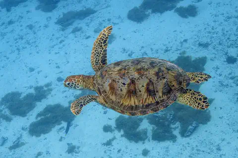
Sea turtles nest on the beaches of St. John and Buck Island, and scientists have studied them on Buck Island for more than 30 years. The green sea turtle in this photo was taken in French Polynesia.
Island fauna is sparse except for birds, Britannica notes, while the surrounding seas abound in commercial and game species. Buck Island Reef National Monument, which takes in the whole 176-acre islet and its reef, was called 'the finest marine garden in the Caribbean Sea' by President John F. Kennedy; an elkhorn coral barrier reef surrounds two-thirds of the island, and snorkelers are led in small groups along an underwater trail. Its dry forest ranges from tamarinds and gumbo-limbo to cacti and orchids.
Scientists have studied sea-turtle nesting on Buck Island for over 30 years, the Park Service reports, and the national park on St. John recruits volunteers for early-morning nesting surveys on St. John. The green sea turtle pictured was photographed off Moorea, French Polynesia.
Tourism, farms and a free port
People here speak English.
Many visitors come for the warm weather and beautiful scenery. Farms on St. Croix grow fruit like mangoes and bananas.
Britannica says about three out of four people in the U.S. Virgin Islands are Black. English is the official language. Some people on St. Croix also speak Spanish, and some French is spoken on St. Thomas.
Tourism is the biggest part of the economy, helped by the warm climate, beautiful scenery and the islands' status as a free port. Britannica notes that most farmland is on St. Croix, where fruits such as mangoes and bananas and vegetables such as tomatoes are grown. The University of the Virgin Islands, founded in 1962, has campuses on St. Thomas and St. Croix.
Britannica describes a population about three-fourths Black and one-tenth to one-fifth white; English is official, with some French on St. Thomas and Spanish among Puerto Rican immigrants on St. Croix. The population grew rapidly in the mid- to late 20th century through immigration from the U.S. mainland, the eastern Caribbean and Puerto Rico, but the census fell from 106,405 (2010) to 87,146 (2020).
Tourism, based on climate, scenery, fishing, closeness to the U.S. mainland and free-port status, dominates the economy. Rum distilling was the traditional industry; the HOVENSA oil refinery on St. Croix closed in 2012 after more than four decades. About one-fifth of the land is farmland, mostly on St. Croix, where fruits, vegetables and cattle are raised. A bay forest on St. John supplies leaves for the bay rum industry.
Taíno villages to Danish plantations
Long ago, people came here by canoe from South America.
Later, Denmark ruled the islands. In 1917 the United States bought them.
People from the Orinoco River area of South America first reached the islands about 3,000 years ago and later developed the Taíno culture. Columbus reached St. Croix in 1493. Over the next two centuries, Spain, England and France all had settlers or claims here.
Denmark claimed St. Thomas in 1666 and St. John in 1684, and bought St. Croix in 1733. The Danes set up sugar plantations worked by enslaved Africans. Slavery was abolished in 1848. In 1917 Denmark sold the islands to the United States for $25 million. Since 1970 the people have elected their own governor.
Arawakan-speaking people from the Orinoco basin arrived as early as about 1000 BCE, settled in villages around 200 BCE and developed Taíno culture from about 1200 CE; Caribs had become dominant by the time Columbus reached St. Croix in 1493. Spain claimed the islands in 1555; English and French settlers were farming St. Croix by 1625, and St. Croix later passed to the Knights of Malta (1653) and then to the French West India Company.
Denmark claimed St. Thomas in 1666 and St. John in 1684, bought St. Croix in 1733 and built a sugar economy on enslaved African labor; St. Thomas became a major slave market. Alexander Hamilton was taken to St. Croix as a boy in 1765. Slavery was abolished in 1848, and the United States bought the islands for $25 million in 1917. The U.S. Navy ran them until 1931; the Organic Act was revised in 1954, the first popularly elected governor took office in 1970, and constitutional conventions since the 1970s produced drafts that were not ratified.
The U.S. Virgin Islands on the map
Find the Caribbean Sea on the globe.
Look just east of Puerto Rico. The small islands there are the U.S. Virgin Islands.
The U.S. Virgin Islands lie about 18 degrees north of the equator, about 64 kilometers east of Puerto Rico. St. Thomas and St. John are in the north, close to the British Virgin Islands, and St. Croix lies farther south, across open water.
The islands are too small for the globe to draw, so PlayOwl marks them with dots: Charlotte Amalie, Crown Mountain, Cruz Bay, Christiansted, Frederiksted and Buck Island.
Charlotte Amalie lies at about 18.35° N, 64.95° W, and Christiansted at about 17.75° N, 64.75° W, on St. Croix to the south. Puerto Rico is about 64 km to the west, and the British Virgin Islands lie just to the northeast. The territory has no land borders.
At the globe's scale the islands have no outlines, so the map uses markers: Charlotte Amalie, Crown Mountain, Cruz Bay on St. John, Christiansted, Frederiksted and Buck Island.
- Puerto Rico
- about 64 km west
- Highest point
- Crown Mountain, about 474 m
- People (census, 2020)
- 87,146
- St. Croix
- 218 km², the largest island
Amazing facts
-
The United States bought these islands from Denmark.
In 1917 the United States bought the islands from Denmark for $25 million.
Negotiations began in the 1860s; the United States finally bought the islands from Denmark in 1917 for $25 million.
-
Most of the island of St. John is a national park.
Two-thirds of the island of St. John is Virgin Islands National Park.
The National Park Service says two-thirds of St. John is national park, with Taíno petroglyphs, plantation ruins and coral reefs.
-
A president called Buck Island's reef a marine garden.
President John F. Kennedy called Buck Island's reef the finest marine garden in the Caribbean Sea.
President John F. Kennedy called Buck Island Reef 'the finest marine garden in the Caribbean Sea'; it is now a national monument.
-
Alexander Hamilton lived on St. Croix as a boy.
Alexander Hamilton, the American statesman, was taken to St. Croix in 1765 and worked there in a trading office.
Alexander Hamilton, born on Nevis in 1755, was taken to St. Croix in 1765 and worked in a countinghouse there.
Words to know
- territory
- an area that belongs to a country but is not one of its states
- fringing reef
- a coral reef that grows close along a shore
- national monument
- a protected natural or historic place, cared for by a national government
- plantation
- a large farm growing one main crop, such as sugarcane
- free port
- a port where goods can be brought in without paying import taxes
- petroglyph
- a picture or symbol carved into rock long ago
Discovery challenge
-
Which country sold these islands to the United States?
From which country did the United States buy the islands in 1917?
Which European country sold the islands to the United States for $25 million in 1917?
- Spain
- Denmark
- Portugal
Show the answer
Denmark
Denmark!
Denmark, in 1917.
Denmark, after negotiations that began in the 1860s.
-
Which is the biggest island?
Which is the largest of the U.S. Virgin Islands?
Which island, 218 km², is the largest and holds most of the farmland?
- St. John
- St. Thomas
- St. Croix
Show the answer
St. Croix
St. Croix.
St. Croix, in the south.
St. Croix, with Christiansted and Frederiksted.
-
How much of St. John is a national park?
About how much of St. John is national park?
What share of St. John does the National Park Service say is national park?
- About two-thirds
- About one-tenth
- None of it
Show the answer
About two-thirds
About two-thirds. That is most of it!
About two-thirds of the island.
Two-thirds, according to the National Park Service.
-
Which coral grows around Buck Island?
Which endangered coral can snorkelers see at Buck Island?
Which endangered coral forms the barrier reef around two-thirds of Buck Island?
- Elkhorn coral
- Snow coral
- Desert coral
Show the answer
Elkhorn coral
Elkhorn coral.
Elkhorn coral, along the underwater trail.
Elkhorn coral, an endangered species.
Animals of U.S. Virgin Islands
Explore next
-
 Watch
 Country
Puerto Rico
Puerto Rico is the easternmost island of the Greater Antilles, a self-governing commonwealth associated with the United States. Its people have been US citizens since 1917. It has mountains, the El Yunque rain forest and the old forts of San Juan, a World Heritage site. The US Census Bureau estimated 3,184,835 people in 2025.
-
 Watch
 Country
British Virgin Islands
The British Virgin Islands are a British overseas territory in the eastern Caribbean Sea: 4 larger islands and 32 smaller ones. Most are hilly, but Anegada is flat coral. Sailing is the favorite sport, and the main town is Road Town on Tortola. The census in 2010 counted 28,054 people.
-
 Watch
 Country
Denmark
Denmark is a country in northern Europe made of the Jutland peninsula and more than 400 islands, with the sea almost all around. It is low and mostly flat, about 6 million people live there, and its capital, Copenhagen, is full of bicycles.
-
 Watch
 Country
United States
The United States is a large country in North America made of 50 states, from icy Alaska to the warm islands of Hawaii. It has the Grand Canyon, the Mississippi River and Yellowstone, and about 342 million people live there.
-
Watch
Animal
Green sea turtle
The green sea turtle is the largest sea turtle with a hard shell. It lives in warm seas around the world and, unlike other sea turtles, grown-ups eat mostly seagrass and algae. Females swim hundreds or even thousands of kilometers to lay their eggs on the beaches where they hatched long ago.
- Watch Geography Islands An island is a piece of land surrounded by water that is smaller than a continent. Islands form in different ways: some broke away from continents, some were built by volcanoes on the sea floor, and some were made by corals or by waves piling up sand. Because they are cut off by water, islands often have unusual plants and animals.
-
 Watch
 Country
Mexico
Mexico is a large country in southern North America, between the Pacific Ocean and the Gulf of Mexico. It has smoking volcanoes, ancient cities built by the Maya and other peoples, and about 132 million people, many of them in and around Mexico City.
-
 Watch
 Country
Canada
Canada is the second-largest country in the world, stretching across the north of North America from the Atlantic to the Pacific and up into the Arctic. It has the Rocky Mountains, thousands of islands and about 42 million people, who speak English, French and many other languages.
For parents & teachers
What children will learn
- Locate the U.S. Virgin Islands east of Puerto Rico.
- Describe the difference between a fringing coral reef and the land of a mountainous island.
- Explain how the islands passed from Denmark to the United States.
- Describe why parks protect reefs and nesting beaches.
Recommended ages: 3 to 17 · About 15 minutes
Talk about it
- Why might a park lead snorkelers in small groups along a set trail over a reef?
- What would you want to see first: the reefs, the old towns or the mountains? Why?
- Why might a country buy islands far from its mainland?
Try at home or in class
- Turtle nest count: draw a beach on paper, mark pretend nests with dots and practice counting them in sections, like park volunteers do.
- Map the three islands from memory, then check them on a globe or atlas.
Key vocabulary: territory, fringing reef, national monument, plantation, free port, petroglyph
Where these facts come from
- Wikidata , Wikimedia Foundation (CC0 1.0)
- Natural Earth vector data , Natural Earth (NACIS) (Public domain)
- United States Virgin Islands (land, people, economy, Quick Facts) , Encyclopaedia Britannica
- United States Virgin Islands: government and society, history , Encyclopaedia Britannica
- 2020 Island Areas Censuses: U.S. Virgin Islands (Table 1, population 2010 and 2020) , U.S. Census Bureau
- Virgin Islands National Park , National Park Service
- Buck Island Reef National Monument , National Park Service
- PlayOwl region table, version 1 , PlayOwl (PlayOwl original data)
- flag-icons 7.5.0 , Panayiotis Lipiridis and contributors (MIT)
- Wikimedia Commons , Wikimedia Foundation (Per file (public domain, CC0, CC BY or CC BY-SA); see each media record)
Checked, not yet human-reviewed. Last updated November 1, 2026. Spotted a mistake? Tell us.